GPR Survey: Advanced Ground Penetrating Radar Detection
Bhoojal Survey offers India's most advanced GPR survey services using ground penetrating radar technology. Map underground utilities, detect buried structures, and locate water sources — without disturbing the surface at all. Safe, fast, and scientifically proven.
[ Rated 4.9 by more than 500+ Customers Globally ]
24+
Team Members
12+
Sector Expertise
1170+
Happy Clients


Book GPR Survey Today
Bhoojal Survey team using ground penetrating radar for GPR survey — utility detection and subsurface mapping
Finding what lies beneath the ground used to require digging, guessing, or expensive trial-and-error. Today, a professional GPR survey changes everything. Using ground penetrating radar, our bhoojal survey team can map underground structures, detect buried utilities, and locate water sources — without disturbing the surface at all. Safe, fast, and scientifically proven.
Ground-Penetrating Radar and GPR Survey Overview
Ground Penetrating Radar, GPR, and What It Means for Your Site
Ground-penetrating radar is a geophysical techniques that uses radar pulses to image the subsurface of the earth. A GPR survey sends electromagnetic energy into the ground and records how that energy bounces back. The result is a detailed picture of everything hidden beneath your feet.
GPR is used across construction, archaeology, utilities, and groundwater detection worldwide. It is one of the most trusted geophysical tools available today. A single scan can reveal pipes, cables, voids, water layers, and rock formations — all without a single dig.
Our bhoojal survey team brings this technology directly to your site. Whether you need a residential scan or a large industrial survey, we deliver accurate, reliable results every time.
How GPR Works in Ground Penetrating Radar Survey Method
GPR Works, Survey Method, Penetration, and Detection
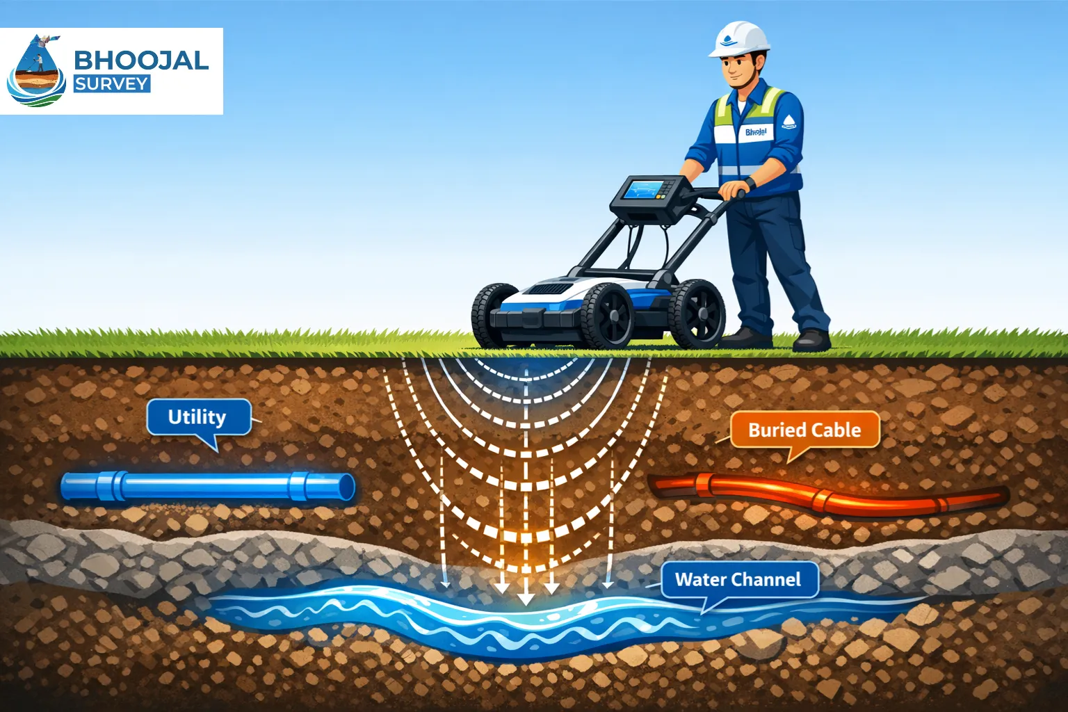
Understanding how GPR works helps you appreciate why it is so powerful. A GPR survey involves using a radar antenna attached to a wheeled unit. The GPR transmitter sends radar pulses into the ground at controlled intervals. These pulses travel through the soil, rock, and other materials beneath the surface.
When a radar pulse hits a material with different electrical properties — such as a pipe, rock layer, or water pocket — it creates a reflect back signal. This reflected radar energy travels back to the surface to the GPR antenna, where it is recorded as GPR data.
The GPR unit is moved slowly across the survey area. As it moves, it continuously sends and receives radar pulses, building a complete GPR profile of the ground below. This survey method is called continuous GPR scanning — and it produces a real-time cross-section image of belowground features.
The frequency of the radar used determines how deep the signal penetrates. Higher frequencies give better image resolution but lower depth of penetrability. Lower frequencies penetrate deeper but with less detail. Our bhoojal survey team selects the right frequency for every project — balancing depth and clarity perfectly.
GPR Scanning and Mapping Surveys for Underground Detection
GPR Scanning, Mapping, Mapping Surveys, Detection
One of the most effective tools for mapping surveys of underground areas is ground penetrating radar. Our GPR survey scanning process covers your entire site systematically — row by row, grid by grid — until every inch of the subsurface is mapped.
GPR surveys provide detailed images of:
- Buried pipes and cables
- Underground voids and cavities
- Water-bearing rock layers and subsurface channels
- Buried objects including old foundations and tanks
- Rock formations and soil layer boundaries
Our bhoojal survey team generates a complete GPR profile map of your site — giving you a clear picture of what lies below before you invest in any borehole. Mapping surveys using ground penetrating radar are especially valuable in urban areas where underground utilities are dense and poorly documented. A single scan can prevent costly and dangerous utility strikes during construction.
GPR System and Radar Services for Utility Surveys
GPR System, Radar Services, Utility, Utility Surveys
Our GPR system is built for precision utility surveys. Every GPR survey we conduct uses calibrated GPR equipment designed for Indian geological and urban conditions. Our radar services cover:
- Underground utilities including water mains, gas lines, and electrical conduits
- Telecom cable mapping and detection
- Drainage and sewer line location
- Borehole GPR for deep subsurface investigation
Utility surveys using ground penetrating radar are now considered best practice before any reflected wave work. Our team follows strict protocols — ensuring every radar signal is correctly interpreted and every GPR anomaly is properly documented.
GPR surveys offer a non-destructive, safe, and highly accurate way to complete utility surveys without digging trial pits or risking damage to existing infrastructure. Our bhoojal survey team brings full radar services to your project — anywhere in India.
Book Professional GPR Survey for Utility Detection
Our certified GPR survey team covers 18+ cities across India. Get a complete subsurface detection report within 48 hours of survey completion.
Call Now: +91-9691858058 View All Survey ServicesRole of GPR Survey in Utility Detection and Mapping
Utility Detection, Mapping, Detection
GPR is used extensively for utility detection across road projects, building sites, and industrial facilities. A professional GPR survey depends on how accurately the operator interprets GPR data — which is why experience matters greatly.
Our team identifies:
- Exact location and depth of underground utilities
- Conflict zones where multiple utilities cross
- Areas of soil disturbance indicating previous excavation
- Potential GPR anomalies suggesting voids or structural weakness
Using ground penetrating radar for utility mapping reduces project delays, prevents accidents, and saves significant money. A proper scan before construction is always cheaper than repairing a severed gas line or water main after the fact.
Our bhoojal survey specialists combine GPR scanning with traditional survey data to deliver the most complete utility detection report possible — verified, documented, and ready for use by your engineering team.
Benefits of Ground Penetrating Radar Detection
Ground Penetrating Radar, Mapping, Detection
The use of ground penetrating radar brings significant advantages over traditional survey methods:
- Non-destructive: No digging, no damage, no disruption to your site
- Fast: A full GPR survey of a standard plot can be completed in hours
- Accurate: Real-time imaging of underground features with high precision
- Versatile: Applications span construction, archaeology, utilities, and groundwater detection
- Safe: No radiation, no chemicals, no environmental impact
- Cost-effective: One survey replaces days of manual investigation and trial digging
- Detailed reporting: Every scan produces a GPR profile with full analysis and written recommendations
Our bhoojal survey clients avoid costly underground surprises. Whether you are planning a new building, a borewell, or a road project — ground penetrating radar gives you the confidence to proceed safely.
GPR Survey Process and Scanning Method
GPR Scanning, Survey Method, Mapping Surveys
Here is how our GPR survey process works from start to finish:
Step 1 — Site Assessment
Our team visits your site and reviews existing plans, ground conditions, and project requirements. We select the right GPR Technologies and radar frequency for your specific soil type and target depth.
Step 2 — GPR Scanning
The GPR unit is moved systematically across the survey area. The radar antenna sends radar waves into the ground continuously. All radar data is recorded in real time through our GPR system.
Step 3 — Data Collection & GPR Profile Generation
Raw GPR signal data is processed using specialist software. Our team performs full analysis of results — identifying every reflected wave, underground object, and subsurface anomaly.
Step 4 — Report & Mapping
We generate a complete GPR profile map of your site. The report includes utility locations, depth readings, GPR anomalies, and professional recommendations. Our bhoojal survey team delivers the report digitally — ready for immediate use on your project.
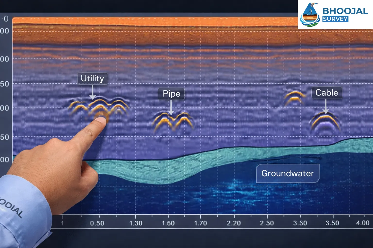
GPR profile output — real-time subsurface cross-section showing underground utilities and anomalies
Limitations and Penetration Challenges
Penetration, Detection, GPR System, Survey
Every honest service provider will tell you — ground penetrating radar has limitations. A professional GPR survey team is always transparent about these:
- Depth of penetration is limited in highly conductive soils such as wet clay. In these conditions, radar energy is absorbed quickly and penetration is reduced significantly.
- Higher frequencies give better resolution but less depth. Lower frequencies reach deeper but with reduced image clarity.
- Electrical properties of the soil affect how well radar signals travel underground.
- In areas with heavy underground utilities, overlapping signals can make interpretation complex.
- GPR data must be interpreted by a trained professional. Incorrect analysis can lead to missed detections or false positives.
Our bhoojal survey team always selects the most appropriate method and combines it with other geophysical tools when needed — ensuring the most reliable results possible for every site.
Need a GPR Survey? Get Expert Subsurface Intelligence Today
Our bhoojal survey team combines GPR scanning with proven groundwater detection technology for a complete underground picture of your site.
Call Now: +91-9691858058 Hydrological SurveyApplications in Utility and Groundwater Detection
Utility Surveys, Radar Services, Mapping
Common applications of ground penetrating radar include a wide range of industries and use cases. Our GPR survey services cover:
- Construction & Civil Engineering: Locating underground utilities before excavation
- Road & Infrastructure: Detecting pavement layers, voids, and subsurface defects
- Archaeology: Mapping buried structures without disturbing the site
- Groundwater Detection: Identifying water-bearing fractures and subsurface channels for borewell planning
- Borehole GPR: Deep subsurface investigation in mining and geotechnical projects
- NDT Survey Technique: Non-destructive testing of concrete slabs, bridges, and tunnels
- Environmental Surveys: Locating buried tanks, contamination zones, and drainage channels
GPR can be used as a standalone tool or combined with other geophysical survey methods for deeper analysis. Our bhoojal survey team offers complete radar services — from basic utility surveys to advanced groundwater detection — all under one professional service.
Why Choose Bhoojal Survey for Radar Services
When it comes to professional GPR survey services in India, bhoojal survey stands apart. Here is why thousands of clients trust us:
- Advanced GPR Equipment: We use calibrated, high-performance instruments suited for Indian ground conditions
- Experienced Team: Our professionals are trained in full analysis of GPR data — not just equipment operation
- Complete Radar Services: From utility surveys to mapping surveys and groundwater detection — all in one visit
- Transparent Reporting: Every report includes raw radar data, interpreted GPR profile maps, and clear written recommendations
- Multi-Technology Approach: We combine GPR scanning with our proven bhoojal survey methods for complete subsurface intelligence
Our team is also experienced in conducting hydrogeological survey using SSRMPATS Instrument, GER DETECT, and PQWT at site for open well / borewell location — giving you a complete scientific picture of both utilities and groundwater in one professional engagement.
For complete subsurface intelligence, trust our groundwater survey service — backed by field experience, advanced technology, and a commitment to accuracy on every project.
FAQs About Ground Penetrating Radar
Q1: What is a GPR survey?
A GPR survey — short for Ground Penetrating Radar survey — is a non-invasive geophysical method that uses radar pulses to image what lies beneath the ground surface. A GPR antenna sends electromagnetic energy into the ground, and when those radar pulses hit a buried object, pipe, or soil boundary, they bounce back as a reflected signal. This signal is recorded and processed into a visual GPR profile — giving you a clear cross-section image of underground conditions without any digging.
Q2: What does a GPR survey show?
It can reveal underground utilities, underground object, voids and cavities, soil and rock layer boundaries, groundwater channels, and concrete reinforcement. The output is a GPR profile combined with a written report identifying every significant subsurface feature found during scanning.
Q3: How accurate is a GPR survey?
A professional GPR survey can locate underground utilities and buried objects within 5–10% of their actual position and depth. Accuracy depends on soil conditions, radar frequency, and operator expertise. When used by an experienced team with calibrated equipment, it is one of the most accurate non-destructive geophysical methods available today.
Q4: How deep can ground penetrating radar penetrate?
Dry sandy or gravelly soil — up to 10–15 metres. Concrete and asphalt — typically 0.5–2 metres. Clay-heavy or wet soil — as little as 0.5–1 metre. Rock formations — up to 30+ metres in ideal dry conditions using low-frequency GPR.
Q5: What is the cost of a GPR survey in India?
A standard residential or small commercial scan starts from ₹5,000–₹15,000 depending on scope. Large industrial or infrastructure surveys are priced based on area and complexity. Contact our bhoojal survey team for a free, site-specific quote.
Q6: How long does a GPR survey take?
Small residential plot — 2 to 4 hours. Medium commercial site — half a day to a full day. Large industrial site — 1 to 3 days. Reports are typically delivered within 24–48 hours of the site visit.
Q7: Can GPR be used on all types of ground surfaces?
GPR works on most surfaces. Dry sandy soil, gravel, rock, concrete, asphalt, and open grassland all give good results. Wet clay and saltwater-saturated soils reduce penetration depth significantly. Our bhoojal survey team always assesses ground conditions before beginning any scan.
Q8: How does a GPR survey work?
The GPR unit is moved slowly across the ground. The radar sensor sends high-frequency pulses downward. When a pulse hits a material with different electrical properties, a reflected signal returns to the surface. The GPR system records this data and converts it into a GPR profile — a cross-section image of everything underground.
Conclusion – Advanced Ground Penetrating Radar for Accurate Mapping and Detection
Underground surprises are expensive, dangerous, and completely avoidable. A professional GPR survey from our bhoojal survey team gives you complete subsurface intelligence — before you dig, drill, or build.
From utility detection and mapping surveys to groundwater location and borehole investigation — our ground penetrating radar services cover every need. We combine the power of GPR scanning with decades of field experience to deliver results that are accurate, reliable, and actionable.
Ground penetrating radar is no longer a luxury — it is a necessity for any serious construction, infrastructure, or borewell project. Our bhoojal survey team is ready to bring this technology to your site — anywhere in India.
Don't dig blind. Book your professional survey today. Contact our bhoojal survey team now and get a complete underground map of your site before your project begins. Visit our groundwater survey service page to schedule your GPR survey — fast, accurate, and fully professional.
Scheme No. 114, Part-2, Indore, Madhya Pradesh – 452010, India
Phone: +91-9691858058
Email: [email protected]
Website: www.bhoojalsurvey.in
Hours: Monday – Saturday, 9:00 AM to 6:00 PM IST
Don't Dig Blind — Book Your GPR Survey Today
Bhoojal Survey's expert team brings world-class ground penetrating radar technology to your doorstep. One survey. Complete subsurface intelligence. Zero guesswork.
Call +91-9691858058 Now Book Survey Online View All Survey Services