Hydrogeological Survey: A Complete Guide
Watch our Hydrogeological Survey Guide
Water beneath the ground is hidden but vital. Every factory, every farm, and every city depends on groundwater for survival. But drilling a borewell blindly is like gambling with lakhs of rupees. Will you strike water, or will your drill go 500 feet deep into dry rock? This is where a professional Hydrogeological Survey becomes your scientific advantage.
At Bhoojal Survey, we believe that understanding the underground world saves millions of rupees and ensures sustainable water supply for decades. In this comprehensive guide, we will explain everything you need to know about a Hydrogeological Survey in simple language — what it is, why it is absolutely critical, how we conduct it scientifically, and why your project's water security depends on it.
1. What is a Hydrogeological Survey?
A Hydrogeological Survey is the detailed scientific study of groundwater. It involves analyzing the geology beneath your land and mapping exactly where water exists underground, how much water is available, and how that water moves through rock and soil layers.
Many people confuse "Hydrology" with "Hydrogeology." Here is the clear distinction:
- Hydrology studies water above the ground — rain, rivers, lakes, streams, and floods.
- Hydrogeology studies water under the ground — groundwater, borewells, aquifers, and water tables.
A Hydrogeological Survey answers three critical questions for your site:
- Location: Where exactly is the groundwater located beneath your land?
- Quantity: How much water is available? Will it be enough for your needs?
- Quality: Is the water safe for drinking, or does it contain harmful salts and chemicals?
By answering these questions scientifically, the Hydrogeological Survey helps you drill borewells at the right location and the right depth — ensuring success and eliminating expensive dry borewells.
2. Why is a Hydrogeological Survey So Important?
Imagine investing ₹10 lakhs to build a new factory. You need water for operations. Without proper research, you hire a local driller who drills a 400-foot borewell based on "experience and intuition." After spending ₹2 lakhs, you get only 2 liters per minute — barely enough for a bathroom tap, let alone a factory. The borewell fails. You drill another. That also fails. Your investment is wasted, and your opening is delayed by months.
This scenario happens every day across India. Here is why a Hydrogeological Survey before drilling is absolutely critical:
A. Preventing Failed Borewells
Groundwater doesn't exist uniformly everywhere underground. It flows through cracks in rocks called fractures, and through porous soil layers called aquifers. A Hydrogeological Survey uses scientific equipment to locate these exact water-bearing zones. Without a survey, drilling is pure guesswork. With a survey, drilling becomes precision engineering with 80–90% success rates.
B. Saving Massive Amounts of Money
A single borewell in hard rock areas can cost ₹1.5 to ₹3 lakhs. Three unsuccessful borewells based on guesswork waste ₹9 lakhs. A professional Hydrogeological Survey costs ₹50,000 to ₹1.5 lakhs depending on site size, and virtually guarantees your first borewell succeeds. Spending ₹1 lakh on a survey saves you from wasting ₹9 lakhs on failed drilling.
C. Understanding Long-Term Water Sustainability
It's not just about finding water once — it's about ensuring that water source lasts 20–30 years. A Hydrogeological Survey calculates the recharge rate: how fast groundwater refills naturally after pumping. This prevents the common problem of a borewell that works for two years, then dries up because the aquifer depleted faster than nature can refill it.
D. Government and Environmental Compliance (CGWA NOC)
In India, industries extracting more than 10,000 liters of groundwater per day must obtain a No Objection Certificate (NOC) from the Central Ground Water Authority (CGWA). This NOC requires a detailed Hydrogeological Report proving your extraction won't harm the regional water table or affect neighboring farmers' wells. Without this compliance report, your industry cannot legally operate groundwater extraction borewells.
3. Who Needs a Hydrogeological Survey?
Any project that depends on groundwater needs a professional Hydrogeological Survey. Here are the main sectors we serve:
Industrial Manufacturing Units
Factories need large volumes of water for cooling machinery, washing products, and manufacturing processes in pharmaceuticals, textiles, and food processing.
The Risk: Setting up a factory worth crores, only to discover insufficient groundwater to run operations.
The Solution: A Hydrogeological Survey before land purchase tells you exactly how many borewells you'll need and whether the site can sustain your water requirements for decades.
Agricultural and Irrigation Projects
Farmers invest heavily in drip irrigation systems, greenhouses, and high-value crops — all dependent on reliable year-round groundwater supply.
The Risk: Spending lakhs on irrigation infrastructure, only to have your borewell dry up in summer when crops need water most.
The Solution: Our survey identifies the best aquifer zones and advises sustainable pumping limits to ensure year-round water availability without depleting the aquifer.
Real Estate Developers and Townships
When building residential colonies or commercial complexes, developers must ensure adequate water supply for hundreds or thousands of future residents.
The Risk: Selling flats with a promise of 24/7 water supply, then facing angry residents when borewells fail during summer — damaging your reputation and triggering legal disputes.
The Solution: A Hydrogeological Survey helps plan how many borewells the township needs, where to drill them, and whether artificial recharge systems are necessary to maintain long-term supply.
4. The Step-by-Step Process: How We Conduct a Hydrogeological Survey
At Bhoojal Survey, we follow a systematic scientific approach for every project. It's not about magic sticks or guesswork — it's about data, technology, and geological expertise. Here is our proven 6-step process:
Step 1: Desktop Study and Secondary Data Collection
Before visiting your site, we conduct extensive research. We study geological maps from the Geological Survey of India (GSI), review existing borewell data from nearby areas, analyze satellite imagery to identify rock formations and lineaments (underground fractures where water accumulates), and collect rainfall and groundwater level data from the Central Ground Water Board (CGWB).
Step 2: Detailed Site Reconnaissance
Our geologists visit your site for ground-level verification. We study exposed rock formations — granite, basalt, sandstone, or limestone — because each rock type stores and transmits water differently. We map existing borewells in the area, interview owners about depth, yield, and seasonal variation, and observe natural indicators like vegetation patterns that signal shallow groundwater.
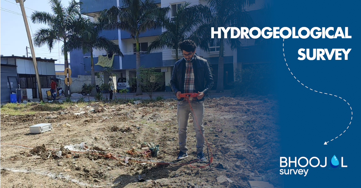
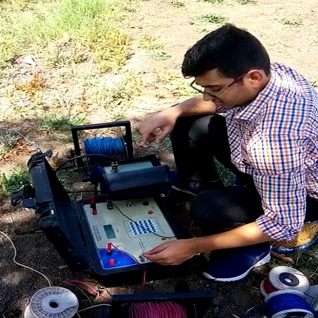
Step 3: Geophysical Survey Using Advanced Equipment
This is where science truly shines. We deploy specialized geophysical instruments to see underground without any digging:
Electrical Resistivity Survey: Electrical current is injected into the ground. Water-bearing zones conduct electricity better than dry rock, creating distinctive resistivity signatures on our graphs.
Ground Penetrating Radar (GPR): Electromagnetic waves sent underground create images of subsurface layers and fractures where water accumulates — similar to a medical ultrasound.
Seismic Refraction: Shock waves are measured as they travel through underground layers, identifying porous aquifer zones versus solid impermeable rock.
Step 4: Aquifer Mapping and Interpretation
Our hydrogeologists analyze all collected data to create detailed cross-sectional diagrams of the underground geology, layer by layer. We identify primary aquifers (main water storage zones), secondary aquifers (backup zones), and confining layers (impermeable rock that traps pressurized water). We then mark the precise locations with the highest probability of striking abundant groundwater.
Step 5: Water Quality Assessment
We collect water samples from existing nearby borewells and send them to certified laboratories. We test for Total Dissolved Solids (TDS), fluoride, arsenic, nitrates, hardness, pH, and other parameters per BIS standards. This ensures groundwater quality meets drinking water standards or identifies if treatment systems will be required.
Step 6: The Comprehensive Hydrogeological Survey Report
We compile everything into a detailed report including: geological maps, geophysical survey results, GPS-marked recommended borewell locations, advised drilling depth, expected water yield in liters per minute, water quality analysis, and a sustainability assessment specifying safe annual extraction limits. This report also serves as the Hydrogeological Report required for CGWA NOC applications.
5. Technology Used in Modern Hydrogeological Surveys
Fifty years ago, groundwater surveys relied on personal experience and water divining rods — an unscientific method. Today, Hydrogeological Surveys use cutting-edge technology for precise, data-driven results:
- Remote Sensing and Satellite Imagery: NASA and ISRO satellites with specialized sensors detect underground water signatures from space, helping identify large-scale geological lineaments invisible to the naked eye.
- GIS (Geographic Information Systems): We create digital 3D models of your site's geology, integrating satellite data, ground surveys, and historical borewell data to visualize and analyze the subsurface in three dimensions.
- Automated Borewell Data Loggers: Sensors installed in existing borewells continuously monitor water levels and transmit data wirelessly, revealing how the aquifer responds to seasonal changes and pumping stress.
- Hydrochemical Laboratory Analysis: Advanced equipment detects contaminants at parts-per-billion levels, ensuring groundwater meets the strictest BIS and WHO safety standards.
6. Why Choose Bhoojal Survey?
Here is why Bhoojal Survey is the preferred choice for India's leading corporations and government agencies for Hydrogeological Survey services:
1. Expert Geological Team: Our team includes licensed geologists and hydrogeologists with M.Sc. and Ph.D. qualifications and extensive fieldwork across India's diverse geological terrains — from the hard rock Deccan plateau to alluvial Indo-Gangetic plains to coastal aquifer systems.
2. State-of-the-Art Survey Equipment: We invest in the latest geophysical survey instruments from leading global manufacturers, regularly calibrated to ensure the highest accuracy in subsurface imaging and groundwater detection.
3. 500+ Completed Projects with Proven Track Record: We have successfully delivered over 500 Hydrogeological Survey projects for clients including NTPC, Coal India, Adani Group, Infosys, Cipla, and Lupin. Our borewell success rate exceeds 85%, far above the industry average of 40–50% for non-surveyed drilling.
4. End-to-End Groundwater Consulting: We don't just hand you a report. We provide drilling supervision, pump selection guidance, water treatment system design, and long-term aquifer management plans — making us your complete groundwater partner from survey to sustainable extraction.
5. Fast Turnaround — Reports in 10–15 Days: We understand project timelines are critical. Our streamlined processes deliver detailed survey reports within 10–15 working days without compromising quality, keeping your construction schedule on track.
7. Frequently Asked Questions (FAQ)
Q1: How long does a Hydrogeological Survey take?
For a typical industrial site (10–50 acres), fieldwork takes 3–5 days. Data processing, laboratory analysis, and report preparation take another 7–10 days. The comprehensive report is delivered within approximately 2 weeks from survey commencement.
Q2: My neighbor has a working borewell. Does my land automatically have good groundwater?
Not necessarily. Groundwater exists in fractures and aquifers that can vary dramatically over short distances. Your neighbor's borewell might have hit a major fracture zone by chance, while drilling 100 meters away could hit solid impermeable rock. A Hydrogeological Survey scientifically locates the best water zones on your specific land.
Q3: Is a Hydrogeological Survey required for CGWA NOC approval?
Yes. Industries extracting more than 10,000 liters of groundwater per day must obtain a No Objection Certificate (NOC) from the Central Ground Water Authority (CGWA). A detailed Hydrogeological Report is mandatory for this NOC application. Without this compliance report, industrial groundwater extraction is not legally permitted.
Q4: Can you conduct Hydrogeological Surveys in hilly or difficult terrains?
Absolutely. Our equipment and experienced field teams work in challenging terrains including hills, forests, and rocky outcrops. We have successfully completed surveys in the Western Ghats, Himalayan foothills, and remote Deccan plateau locations.
Q5: What is the cost of a Hydrogeological Survey in India?
Costs vary based on site size, terrain complexity, and survey methods used. Surveys typically range from ₹50,000 for small residential plots to ₹2–3 lakhs for large industrial sites requiring extensive geophysical investigation. This investment prevents waste of ₹5–10 lakhs on failed borewells, delivering a clear return on investment.
Q6: What is the difference between a Hydrogeological Survey and a Geophysical Survey?
A Geophysical Survey is one tool within a Hydrogeological Survey. A complete Hydrogeological Survey includes desktop geological study, site reconnaissance, geophysical investigation (electrical resistivity, GPR, seismic), aquifer mapping, water quality testing, and a comprehensive report with sustainable extraction recommendations. A standalone geophysical survey only covers the instrument-based underground imaging step.
Conclusion
Groundwater is India's invisible wealth — the lifeline for agriculture, industry, and drinking water. But this resource is finite and fragile. A Hydrogeological Survey is not just a technical report; it is your roadmap to water security. It is the scientific foundation ensuring your factory runs smoothly, your crops flourish, and your community thrives even during the harshest summers.
Don't gamble with groundwater. Don't waste money on failed borewells based on guesswork. Contact Bhoojal Survey today for a scientifically rigorous Hydrogeological Survey — and let us help you unlock the hidden water wealth beneath your land with precision, sustainability, and proven success.


