Professional Ground Water Survey in Khargone: The Scientific Solution
Khargone, the heart of the Nimad region, is known for its incredible agricultural output, especially cotton and chillies. However, the region faces a significant challenge: a dropping water table and complex geological formations. A professional Ground Water Survey in Khargone is the only way to ensure that your borewell investment is successful. For decades, Bhoojal Survey has been the leader in providing Ground Water Survey in Maheshwar and surrounding areas, helping thousands of farmers and industries secure their water future.
The geography of Khargone consists primarily of Deccan Trap basalts—hard volcanic rocks that do not allow water to flow easily. Finding water in such a terrain requires detecting specific rock fractures and aquifers. A scientific Ground Water Survey in Khargone uses measurable geophysical data to map these invisible underground layers. Without a proper Ground Water Survey in Maheshwar, drilling a borewell is like gambling with your hard-earned money. Our scientific method ensures a success rate of over 95% by targeting deep-seated aquifers that traditional dowsing methods often miss.
Why You Need a Scientific Borewell Survey in Maheshwar
Maheshwar, situated on the banks of the Narmada River, might seem water-rich, but as you move away from the riverbed, the rocky terrain makes it extremely difficult to locate sustainable water sources. A Ground Water Survey in Maheshwar is critical for new hotels, residential projects, and the large-scale agriculture that Nimad is famous for. Our Ground Water Survey in Khargone specializes in locating high-yield points even in the most challenging rocky patches like Bistan, Sanawad, and Barwah.
When you opt for a Ground Water Survey in Khargone, we provide:
● Precise mapping of water-bearing fractures in hard basaltic rock.
● Accurate depth estimation to ensure your borewell reaches the primary aquifer.
● Scientific yield analysis to predict the gallons per hour your well will produce.
● Detailed strata reports to help your driller choose the right equipment.
● Professional consultancy for CGWA NOC and groundwater management.
Technologies Used for Ground Water Survey in Khargone
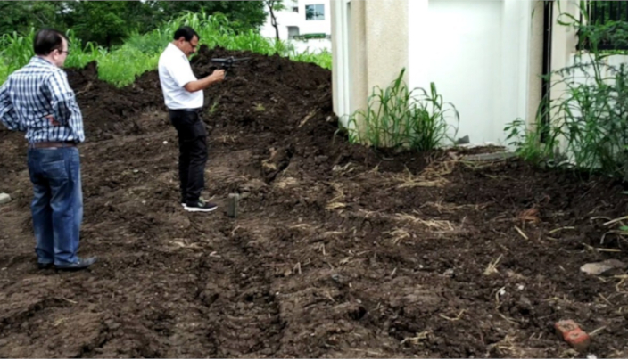
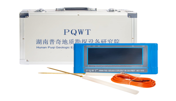
Bhoojal Survey uses international-standard geophysical instruments for every Ground Water Survey in Khargone. Our primary tools include the PQWT multichannel natural electric field detector and the GER detect long-range systems. These tools allow our hydrogeologists to "see" beneath the earth without any excavation. A Ground Water Survey in Maheshwar conducted with these tools eliminates human error and provides a clear, data-driven picture of the subsurface structure.
1. PQWT Multichannel Survey
The PQWT instrument is a revolutionary tool for Ground Water Survey in Khargone. It measures the natural electric field of the earth and processes the frequency to create a visual graph. In the rocky terrains of Nimad, it helps distinguish between dry rock and water-saturated fractures. Every Ground Water Survey in Maheshwar we perform involves multiple readings to cross-verify the presence of a stable water source.
2. Electrical Resistivity (Schlumberger Method)
For industrial clients in the Khargone Bypass or Sanawad industrial areas, we use the Schlumberger resistivity method. This is the most trusted geophysical technique globally for deep-water exploration. A Ground Water Survey in Khargone using resistivity helps map the horizontal and vertical extent of the aquifer, ensuring that your industrial tubewell never goes dry, even in peak summer.
Strategic Benefits of Ground Water Survey in Maheshwar
Maheshwar is a growing hub for heritage tourism and smart city developments. Ensuring a 24/7 water supply is essential for these developments. A scientific Ground Water Survey in Maheshwar helps town planners and developers identify the best spots for heavy-duty borewells. Our Ground Water Survey in Khargone also assists the local farming community in Bikangaon and Kasrawad, where water scarcity is a major hurdle for chilli and cotton farming.
Methodology of Our Ground Water Survey in Khargone
We follow a rigorous five-step process for every Ground Water Survey in Khargone. First, we analyze the local geological map and satellite imagery. Second, we perform a site reconnaissance to identify natural recharge points. Third, we deploy our geophysical instruments to collect data points. Fourth, our senior hydrogeologists interpret the graphs and curves. Finally, we mark the point on your land and provide a technical report for the drilling team.
By choosing a professional Ground Water Survey in Khargone, you are choosing a sustainable future. Over-drilling dry wells depletes your financial resources and harms the local ecosystem. A data-backed Ground Water Survey in Maheshwar ensures that we only drill where nature provides, maintaining the ecological balance of the beautiful Nimad region.
Supporting the Nimad Industrial & Agricultural Belt
Khargone is home to several ginning mills and textile industries. For these units, a Ground Water Survey in Khargone is a statutory requirement for CGWA NOC compliance. We provide complete technical support, including hydrogeological reports and rainwater harvesting designs. Our Ground Water Survey in Maheshwar has also been instrumental in the success of many farmhouse projects and agro-tourism ventures along the Indore-Khargone highway.
FAQs: Ground Water Survey in Khargone & Maheshwar
● What is the best time for a Ground Water Survey in Khargone? While surveys can be done year-round, the summer months (April-June) are ideal as they show the lowest possible water table, ensuring your well is reliable in all seasons.
● How accurate is a Ground Water Survey in Maheshwar? Our scientific methods provide an accuracy rate of over 95%, which is the highest in the industry.
● Is a survey required for residential borewells? Absolutely. Even a 4.5-inch residential borewell costs a significant amount. A survey ensures you don't drill a dry hole.
● Do you provide services in remote villages of Khargone? Yes, we cover the entire district, including Bhikangaon, Sanawad, Barwah, and Segaon.
● How deep can your instruments detect water? Our advanced tools can map aquifers up to a depth of 800 to 1000 feet, which is necessary for the deep fractures found in Nimad basalt.
What Our Clients Say
We had two dry borewells at our farm in Khargone. Bhoojal Survey performed a scientific Ground Water Survey in Khargone and found a high-yield point at 520 feet. Excellent work!
Agrawal Cotton Ginning
Khargone, MP
Best team for Ground Water Survey in Maheshwar. They pinpointed the exact depth and the drilling results were exactly as predicted in the report.
Siddharth Meena
Maheshwar, MP
Bhoojal Survey is your most trusted partner for Ground Water Survey in Khargone and Ground Water Survey in Maheshwar. Don't leave your water security to chance. Use science, use technology, and ensure a lifetime of sustainable water. Contact us today for a professional site inspection.