The Critical Need for Ground Water Survey in Jabalpur
Jabalpur, known for its majestic Marble Rocks and its location on the banks of the Narmada river, presents a fascinating yet complex hydrogeological puzzle. For residents, farmers, and industries in areas like Richhai, Vijay Nagar, and Madan Mahal, finding water isn't just about digging a hole; it's about understanding the hidden layers of granite, dolomite, and alluvial soil. A professional ground water survey in jabalpur is the first and most vital step to avoid the disaster of a dry borewell.
At Bhoojal Survey, we provide specialized services that combine traditional hydrogeological wisdom with modern geophysical technology. Jabalpur's geography is part of the Narmada rift valley, meaning rock fractures and aquifers are highly localized. If you miss a fracture by even a few feet, your borewell might fail. Our survey ensures you hit the mark every time.
Why Scientific Borewell Survey in Jabalpur is Indispensable
Many property owners in Jabalpur still rely on traditional dowsing (using coconuts or sticks), which has a high failure rate in complex hard-rock terrains. A scientific borewell survey in Jabalpur offers measurable data and a 95% success rate. Here is why it is essential:
- ● Geological Mapping: Understanding the transition from river-side alluvial soil to hard bedrock.
- ● Fracture Detection: Identifying "water-bearing zones" within the hard granite and marble formations.
- ● Depth Optimization: Scientific guidance on whether water is at 300 feet or if you need to go up to 800 feet for deep aquifers.
- ● Cost Prevention: A typical borewell in Jabalpur costs ₹80,000 to ₹1.5 Lakh. Our survey costs a fraction of that and prevents this investment from going to waste.
- ● Sustainability Analysis: Predicting how long the water source will last through harsh summers.
Jabalpur’s Unique Geological Challenges
The "Marble City" sits on a variety of rock types. Near Bhedaghat, the ground is dominated by dolomite and marble rocks. In city centers like Wright Town, it’s often weathered basalt and granite. These rocks are non-porous, meaning water only travels through fractures and faults. A ground water survey in Jabalpur uses electrical resistivity to "see" these cracks. Water-saturated fractures show lower resistivity, allowing us to pinpoint high-yield spots with extreme precision.
Advanced Technologies for Accurate Detection
We use a combination of instruments to provide the most reliable ground water survey in Jabalpur:
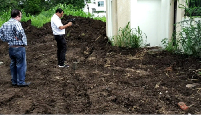
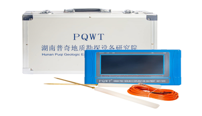
1. PQWT (Multichannel Natural Electric Field Detector)
The PQWT is the most preferred tool for urban borewell point selection in Jabalpur. It is highly portable and unaffected by the noise of city traffic. It produces a real-time graph of the subsurface strata, showing our hydrogeologists exactly where the water-bearing "curves" are located.
2. GER Detect Long Range Systems
For large agricultural lands near Jabalpur, like in Panagar or Patan, we use GER Detect. This long-range sensor scans vast areas to find underground reservoirs and cavities, which we then narrow down using local resistivity probes.
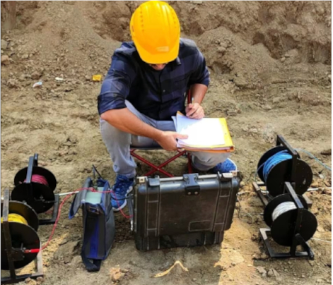
3. Electrical Resistivity (Schlumberger Method)
This is the gold standard of geophysics. By passing a current through electrodes, we map the earth's resistance. In Jabalpur’s terrain, this method is excellent for finding the thickness of the alluvial layer before hitting the hard bedrock, ensuring we find the primary aquifer.
Industrial Ground Water Survey in Jabalpur’s Industrial Belts
Industries in Richhai and the Khamaria region require high-volume water consistently. A random borewell rarely satisfies industrial needs. Bhoojal Survey provides detailed high-yield point detection, helping industries secure their water supply and providing necessary technical documentation for CGWA NOC applications and groundwater management.
Our Success Methodology
When you book a ground water survey in Jabalpur with us, we follow a rigorous scientific process:
- ● Pre-Survey Analysis: Studying the hydrogeological maps and local water table trends.
- ● Site Reconnaissance: Identifying natural recharge zones and rock outcrops on your land.
- ● Instrument Deployment: Using PQWT or Resistivity probes to collect subsurface data.
- ● Data Interpretation: Our senior hydrogeologists analyze the graphs to find the most productive spot.
- ● Technical Report: You receive a comprehensive report with recommended depth and casing size.
FAQs: Ground Water Survey in Jabalpur
- ● Is groundwater easily available in Jabalpur?
Availability varies. Near the Narmada river, it is shallow, but in rocky areas like Gwari Ghat or Madan Mahal, it is deep and hard to find without a survey.
- ● How deep should I drill in Jabalpur?
Typically, 400 to 600 feet. However, in hard granite areas, deep aquifers might be at 800+ feet. Our survey will give the exact recommendation.
- ● Do you provide services for agricultural land in Panagar?
Yes, we cover all areas surrounding Jabalpur, including Patan, Panagar, Shahpura, and Kundam.
- ● Can you find water for a 6-inch borewell?
Yes, our tools help identify the volume of water, ensuring the point is suitable for 6-inch or even industrial-grade tubewells.
- ● Why is my neighbor's borewell successful and mine dry?
Because groundwater in Jabalpur flows through narrow fractures. Your neighbor hit one, but your land might be sitting on a dry, compact rock block. A survey helps find your own specific fracture.
Bhoojal Survey is committed to providing the most reliable ground water survey in Jabalpur. Our scientific expertise ensures your peace of mind and a lifetime of sustainable water. Contact us today for a site visit.


