Table of Contents
- Introduction to GPR Survey
- How Does GPR Work?
- What is a GPR Survey?
- Applications of GPR Survey
- Why Choose Bhoojal Survey for GPR Services?
- Our GPR Survey Process
- Technologies and Equipment We Use
- Key Benefits of GPR Survey
- FAQs about GPR Survey
- Contact Us for GPR Survey Services
1. Introduction to GPR Survey
Ground Penetrating Radar (GPR) is a non-invasive, advanced geophysical technique used to map subsurface structures and detect underground utilities, voids, and anomalies. At Bhoojal Survey, we specialize in providing accurate, reliable, and efficient GPR survey services tailored to meet the unique needs of our clients.
Ground Penetrating Radar Survey is mostly used for detecting underground pipelines, both metallic and non-metallic, installed beneath earth surfaces. In correlation with leak detection instruments, pipeline leakage detection can be traced.
Why Choose GPR Survey?
- Versatile: Suitable for various applications, including metallic pipe detection, non-metallic pipe detection, water pipeline detection, pipeline leakage detection, utility detection, concrete inspection, and archaeological surveys.
2. How Does GPR Work?
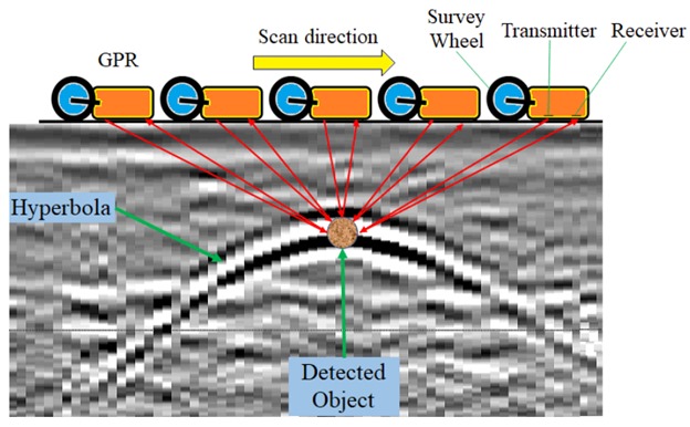
GPR works by emitting electromagnetic waves into the ground and analyzing the reflected signals. We transmit electromagnetic waves into the ground using a sender antenna. It hits objects, such as utility lines buried inside the ground, and the receiver antenna records the signal.
A lower frequency antenna penetrates deeper, while a higher frequency antenna penetrates shallow depths. The depth of the object depends on the time taken to reflect signals. Larger objects produce wider hyperbolas, while smaller objects create tighter ones. Deeper objects generate wider hyperbolas due to the increased travel time of the signal.
As the antenna moves over an object, the vertical distance (time of the reflected signal to arrive at the antenna) decreases until the antenna is above the object, and it increases as the antenna moves past the object. Therefore, a single object will appear in the GPR output data as a hyperbola.
Here’s how the process works:
- Radar Pulse Emission: A GPR antenna emits electromagnetic waves into the ground.
- Signal Reflection: The waves reflect off underground objects, such as pipes, cables, and voids.
- Data Collection: The reflected signals are captured by the GPR system.
- Data Analysis: Specialized software processes the data to create a detailed subsurface image.
- Object Identification: Underground objects and anomalies are identified based on the reflected signals.
Advantages of GPR
- Accurate Object Location: Pinpoints exact locations of underground objects without excavation.
- Time-Efficient: Provides real-time data, reducing downtime.
- Cost-Effective: Minimizes project costs by avoiding unnecessary digging.
- Safe: Non-destructive method ensures safety for workers and the environment.
3. What is a GPR Survey?
A GPR survey is a geophysical method that uses high-frequency electromagnetic waves to map subsurface structures. It is widely used for detecting underground utilities, pipeline detection, and pipeline leakage detection. GPR works by emitting radar pulses into the ground and analyzing the reflected signals to create a detailed image of the subsurface.
Key Features of GPR Survey
- Non-Invasive: No digging or excavation required.
- High Accuracy: Provides precise location data for underground objects.
- Real-Time Data: Immediate results for quick decision-making.
- Versatile: Works on various soil types and materials, including concrete, asphalt, and soil.
- Depth Penetration: A lower frequency antenna penetrates deeper, while a higher frequency antenna penetrates shallow depths.
4. Applications of GPR Survey
GPR surveys have a wide range of applications across industries. Here are some key uses:
Utility Detection
- Locating Underground Utilities: Detects pipes, water pipelines, metallic and non-metallic pipelines, gas pipelines, and leakage detection cables to prevent damage during excavation.
- Mapping Utility Networks: Provides detailed maps of underground utility networks for planning and maintenance.
Concrete Inspection
- Rebar and Post-Tension Cable Detection: Identifies rebar and post-tension cables in concrete structures.
- Void Detection: Detects voids and cracks in concrete slabs and structures.
Archaeological Surveys
- Site Mapping: Maps archaeological sites to identify buried structures and artifacts.
- Non-Invasive Excavation: Provides detailed subsurface images without disturbing the site.
Environmental Studies
- Contaminant Mapping: Identifies underground contaminants and pollution plumes.
- Groundwater Studies: Maps groundwater levels and flow patterns.
Geotechnical Investigations
- Soil Stratigraphy: Analyzes soil layers and properties for construction projects.
- Void and Cavity Detection: Identifies underground voids and cavities that may pose risks.
5. Why Choose Bhoojal Survey for GPR Services?
At Bhoojal Survey, we are committed to delivering accurate, reliable, and efficient GPR survey services. Here’s why you should choose us:
Expertise and Experience
- Our team of skilled professionals has extensive experience in conducting GPR surveys for various applications.
- We have successfully completed numerous projects, earning the trust of our clients.
Advanced Technology
- We use state-of-the-art GPR equipment and software to ensure high accuracy and precision.
- Our technology is capable of detecting underground objects in various soil and material conditions.
Customer-Centric Approach
- We work closely with our clients to understand their specific needs and provide tailored solutions.
- Our commitment to timely delivery and quality assurance ensures that you receive the best possible service.
Comprehensive Reporting
- We provide detailed reports, including maps, charts, and actionable insights, to help you make informed decisions.
- Our reports are easy to understand and tailored to meet the requirements of your project.
6. Our GPR Survey Process
At Bhoojal Survey, we follow a systematic and efficient process to ensure the highest level of accuracy and reliability. Here’s how we conduct GPR surveys:
Step 1: Project Planning
- We begin by understanding your specific requirements and defining the objectives of the survey.
- Our team conducts a preliminary assessment to determine the scope of the project and plan the survey accordingly.
Step 2: Data Collection
- Using advanced GPR equipment, we collect high-resolution data along the survey area.
- Our equipment is calibrated to ensure accurate measurements.
Step 3: Data Analysis
- The collected data is processed using specialized software to create detailed subsurface images.
- We analyze the data to identify underground objects and anomalies.
Step 4: Object Identification
- Based on the data analysis, we pinpoint the exact locations of underground objects and anomalies.
- We provide detailed maps and charts highlighting the identified objects.
Step 5: Reporting and Consultation
- We create comprehensive reports, including actionable insights and recommendations.
- Our team presents the findings to you and provides additional support as needed.
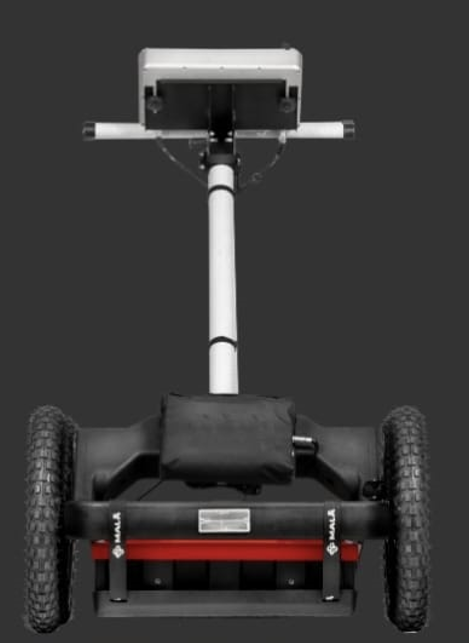
7. Technologies and Equipment We Use
At Bhoojal Survey, we use state-of-the-art technologies and equipment to ensure the highest level of accuracy and precision. Here’s what we use:
GPR Systems
- We use high-frequency GPR systems capable of detecting underground objects in various soil and material conditions.
- Our systems provide real-time data, enabling quick decision-making.
Data Processing Software
- We use specialized software to process the collected data and create detailed subsurface images.
- Our software enables us to analyze the data efficiently and provide actionable insights.
GPS and Mapping Tools
- We use GPS and mapping tools to accurately locate underground objects and anomalies.
- Our tools ensure precise mapping of the survey area and identified objects.
8. Key Benefits of GPR Survey
GPR surveys offer numerous benefits, making them an essential tool for various industries. Here are some of the key advantages:
- Accurate Object Detection: GPR surveys provide precise location data for underground objects, ensuring accurate detection.
- Non-Invasive Method: No digging or excavation is required, minimizing disruption to the surrounding area.
- Cost-Effective: Reduces project costs by pinpointing exact locations of underground objects and avoiding unnecessary digging.
- Time-Efficient: Provides real-time data, reducing downtime and ensuring quick decision-making.
- Versatile: Suitable for various applications, including utility detection, concrete inspection, and archaeological surveys.
9. FAQs about GPR Survey
Here are some frequently asked questions about GPR surveys:
What is the cost of a GPR survey?
- The cost depends on the scope of the project, including the size of the area and the level of detail required. Contact us for a customized quote.
How long does a GPR survey take?
- The duration varies based on the size of the area and the complexity of the project. We provide a timeline during the planning phase.
What types of materials can GPR penetrate?
- GPR can penetrate various materials, including soil, concrete, asphalt, and rock. However, its performance may vary in highly conductive materials, such as clay.
How accurate is GPR?
- Our GPR surveys provide high accuracy, thanks to advanced technologies and skilled professionals.
Can GPR detect all types of underground objects?
- GPR is effective in detecting most underground objects, including pipes, cables, and voids. However, its performance may vary depending on the material and soil conditions.
Can GPR Be Used For Underground Pipeline Leak Detection?
- Ground Penetrating Radar (GPR) is a powerful tool for finding underground pipe leaks. By transmitting radar energy into the ground and monitoring the strength and time delay of any reverberations, it can detect changes in underlying soil or structural irregularities that could signify a leak.
10. Contact Us for GPR Survey Services
Ready to get started? Contact Bhoojal Survey today for a consultation. Our team of experts is here to provide you with the best GPR survey services tailored to your needs.
- Phone: +91 96918 58058
- Email: [email protected]
- Contact Form: [Link to Contact Form]