You cannot see underground water with the naked eye — but a satellite survey can. At Bhoojal Survey, we use space-based remote sensing technology and advanced GIS software to tell you exactly where to drill, how deep to go, and what yield to expect — before you spend a single rupee on boring. This is not guesswork. It is science, refined over two decades of fieldwork across India.
What Is Satellite Survey? The Complete 2026 Answer
A satellite survey is the process of collecting spatial data about the Earth's surface using satellites orbiting in space. Each satellite carries sensors — optical cameras, radar systems, and multispectral instruments — that capture information about land cover, soil composition, water bodies, vegetation density, and underground geological formations.
In the context of groundwater and land planning, satellite survey means feeding this raw orbital data into GIS (Geographic Information System) software and combining it with local geology reports, contour maps, meteorological records, and drainage patterns to create a precise subsurface picture. The result tells us where aquifers exist, how deep they are, and which specific point on your land will give the best borewell yield.
What makes a satellite survey different from traditional field surveys is reach and speed. A ground team needs days or weeks to cover what a satellite covers in a single pass. For remote or difficult terrain — mountains, forests, waterlogged areas — satellite-based data is often the only practical option.
Did You Know? India has over 30 million borewells. A significant number fail because they are drilled in the wrong location. A proper satellite survey before drilling reduces borewell failure rates dramatically — saving both money and groundwater resources.
What Is a Satellite Station in Surveying? (Classic Definition + Modern Context)
Many people search for this term expecting a technical surveying answer — and rightly so. In classical triangulation surveying, a satellite station is an auxiliary point set up near a main triangulation station when the main station itself cannot be directly occupied. This happens when the main station is on a building, a cliff face, or simply inaccessible terrain.
From this satellite station, the surveyor takes angular measurements to surrounding points. Because the satellite station is slightly offset from the true triangulation station, the observed angles need a mathematical correction — called reduction to centre — before they can be used in calculations. This technique has been a cornerstone of precise land surveying for over a century.
In modern satellite survey work, the concept has evolved. Today, satellite stations refer to the network of ground control points (GCPs) used to calibrate and verify satellite imagery. These ground-truthing stations ensure that the coordinates captured from space match real-world positions on the ground with high accuracy. At Bhoojal Survey, we integrate both classical surveying principles and modern satellite-based GIS tools to deliver the most reliable results.
| Term | Classical Surveying | Modern Satellite Survey |
|---|---|---|
| Satellite Station | Auxiliary point near inaccessible triangulation station | Ground Control Point (GCP) for imagery calibration |
| Main Use | Angle measurement with mathematical reduction | Accuracy verification of satellite data |
| Tools | Theodolite, chain, levelling staff | GNSS/GPS receiver, GIS software, DEM |
| Coverage | Limited to line-of-sight | National and global scale |
How Accurate Is Satellite Surveying in 2026?
Accuracy is the question every serious client asks — and it deserves an honest, detailed answer. Satellite survey accuracy in 2026 depends on three factors: the type of satellite system used, the quality of ground control points, and the processing methodology applied to the raw data.
Here is a clear breakdown of accuracy by technology type:
| Technology | Typical Accuracy | Best Use Case |
|---|---|---|
| GNSS / GPS (RTK) | 1–3 cm horizontal | Precise boundary demarcation, engineering surveys |
| High-res optical satellite (WorldView-3) | 30–50 cm | Land cover mapping, urban planning |
| Radar / SAR satellite | 1–5 m | Flood mapping, subsidence monitoring |
| GIS-based groundwater modeling | Zone accuracy ±15–50 m | Borewell location, aquifer mapping |
| Landsat / Sentinel (free) | 10–30 m | Regional analysis, vegetation, change detection |
Want to Know Where Your Borewell Should Go?
Share your GPS location — we will run a full satellite survey and give you precise borewell coordinates.
What Can Satellite Survey Tell You About Your Land?
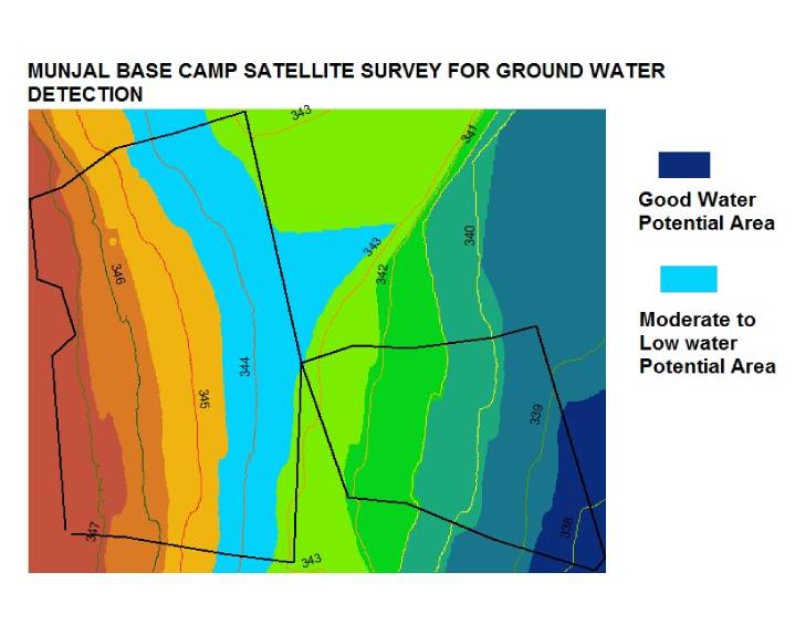
This is where a satellite survey becomes genuinely useful for landowners, farmers, industries, and project developers. Once we process your location data through our GIS platform, we can extract the following critical information about your specific site:
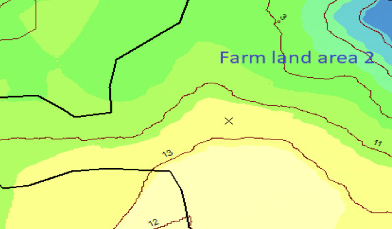
Rock type, fault lines, fracture zones, and soil composition — all mapped from space and cross-referenced with geological databases.
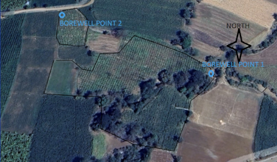
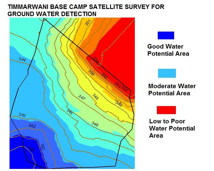
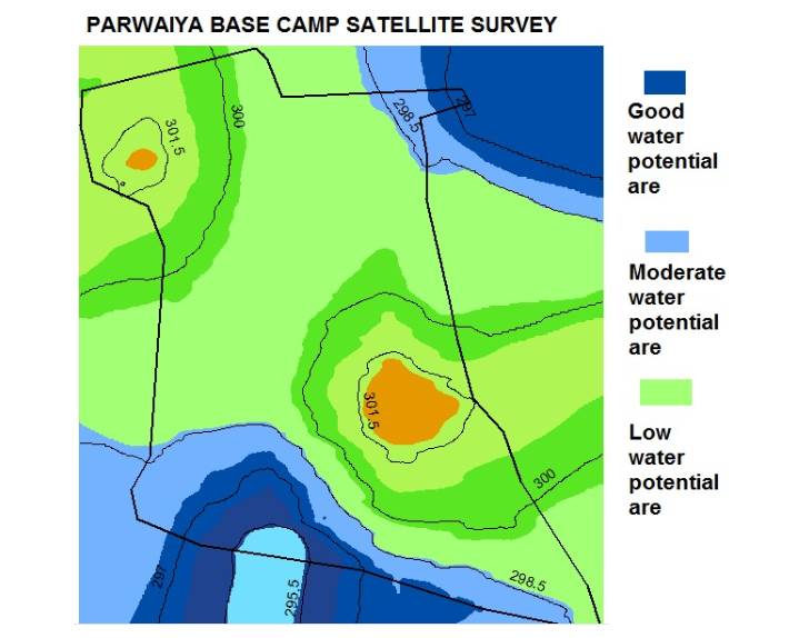
Precise coordinates where your borewell should be drilled, based on subsurface water indicators detected through multi-layer GIS analysis.
An estimated water output range (litres per hour / day) based on aquifer characteristics and recharge zone analysis in your area.
Recommended borewell diameter, casing size, and depth — so your drilling contractor works with accurate technical parameters from day one.
Identification of shallow and deep aquifer zones, their lateral extent, thickness, and recharge potential — critical for sustainable water planning.
Mapping of natural water storage zones — seasonal streams, percolation tanks, and recharge areas that influence groundwater availability on your land.
How Is a Satellite Survey Conducted? Step-by-Step Process
The process behind every satellite survey at Bhoojal Survey is structured and transparent. Here is exactly what happens from the moment you share your location to the moment you receive your borewell report:
You share your land location via WhatsApp GPS pin, Google Maps link, or GPS coordinates. No site visit required at this stage. This single input triggers the entire survey process.
We pull high-resolution satellite imagery of your area from platforms including Sentinel-2, ISRO's Cartosat, and commercial providers. Multi-date images are selected to capture seasonal variations.
Local geological survey maps, rainfall records, soil reports, and contour data are fed into our GIS platform alongside the satellite imagery for multi-layer analysis.
Our specialists run the integrated dataset through GIS analysis algorithms — identifying fracture zones, lineaments, drainage patterns, and recharge zones that indicate groundwater presence.
The analysis pinpoints the optimal borewell location on your specific land parcel — with coordinates, depth recommendations, and expected yield range documented clearly.
You receive a comprehensive satellite survey report including all findings, maps, borewell specifications, and recommendations — delivered digitally within the agreed timeline.
Five Reasons Satellite Survey Outperforms Traditional Ground Survey
Before satellite survey technology became accessible, finding groundwater required expensive geophysical equipment, experienced field teams, and weeks of site work. Here is how the modern satellite approach compares:
Mountains, forests, flooded plains — satellite surveys work everywhere. No access constraints, no weather delays for data collection.
A satellite survey can cover thousands of hectares in the time it takes a ground team to survey a few acres. Results in days, not months.
No travel expenses, no large field crews, no rented equipment. Satellite surveys deliver high-quality data at a fraction of traditional survey costs.
Compare imagery from different seasons and years to track groundwater level changes, land degradation trends, and aquifer recharge patterns over time.
Who Needs Satellite Survey Services? (Industries and Use Cases)
A satellite survey is not just for farmers looking for borewells. The applications span across industries and project types. Here are the primary sectors where our satellite survey expertise delivers measurable value:
- Industries and Factories: CGWA NOC applications require groundwater quantity data that a satellite survey provides efficiently. Large industries needing borewell approvals must establish water requirement justifications — satellite data supports this.
- Real Estate and Township Developers: Site selection for large residential projects depends on water availability data. A satellite survey of land before purchase can prevent costly mistakes.
- Agriculture and Irrigation: Farmers investing in borewells for irrigation benefit enormously from knowing aquifer depth and expected yield before drilling — saving lakhs in dry borewell losses.
- Mining Projects: Underground mining operations require detailed aquifer mapping to plan dewatering systems and assess groundwater impact — both achievable through satellite survey.
- National Highways and Infrastructure: Road alignment studies use satellite survey of land to plan drainage, identify waterlogging zones, and assess slope stability across large corridors.
- Urban Local Bodies: Municipal water supply planning benefits from satellite-based aquifer mapping to identify sustainable groundwater sources across entire city zones.
- Renewable Energy Projects: Solar and wind farm site selection requires terrain analysis, drainage pattern study, and environmental baseline data — all derived from satellite survey.
At Bhoojal Survey, we have conducted successful satellite surveys across all these sectors — from individual farm plots to national highway corridors spanning hundreds of kilometres.

Get Your Land's Satellite Survey Done in 48 Hours
Just share your GPS location. No site visit needed. Report delivered digitally.
How to Share Your Location for a Satellite Survey
Getting started with your satellite survey is simpler than most people expect. The only thing we need from you is your land location. No paperwork, no prior knowledge of GIS, no field visit required. You simply share your GPS location through any of these methods:
- WhatsApp Location Pin: Open WhatsApp, tap the attachment icon, select Location, and share your live location or a dropped pin on your land.
- Google Maps Link: Open Google Maps, navigate to your land, tap and hold to drop a pin, then tap Share to send us the link.
- GPS Coordinates: If you know your latitude and longitude, simply WhatsApp or call us with the coordinates directly.
Watch the step-by-step video guides below — available in both English and Hindi — to understand exactly how to share your location for a satellite survey:
How to Share Location — English
Step-by-step GPS location sharing guide for satellite survey (English)
Location Share Kaise Kare — Hindi
Satellite survey ke liye GPS location share karne ki Hindi mein guide
About Transiting Exoplanet Survey Satellite (TESS) — Important Distinction
Many users searching for "transiting exoplanet survey satellite" or "TESS" are looking for information about NASA's space telescope. Let us clarify: the Transiting Exoplanet Survey Satellite (TESS) is a NASA astrophysics mission launched in April 2018. It monitors the brightness of over 200,000 nearby stars to detect periodic dips in light caused by planets crossing in front of them — a method called the transit method.
TESS has discovered thousands of exoplanet candidates and is a landmark mission in space science. However, it is entirely unrelated to land surveying or groundwater studies. The satellite survey services Bhoojal Survey provides use Earth observation satellites — such as Sentinel-2, Cartosat, and Landsat — that look down at the Earth's surface, not outward into deep space.
If you arrived here looking for TESS information, you may want to visit NASA's official TESS page. If you need satellite survey services for your land or groundwater project in India, you are in the right place.
Why Bhoojal Survey Is India's Trusted Satellite Survey Partner Since 2001
When you engage Bhoojal Survey for a satellite survey, you are not just getting a report — you are getting 24 years of applied groundwater and remote sensing experience. Our team has conducted satellite surveys for some of India's largest infrastructure projects, including national highway corridors, mining operations, urban township developments, and industrial parks.
What sets our satellite survey approach apart is our integration of multiple data sources. Unlike firms that rely solely on one satellite dataset, we layer geological records, historical borewell data, meteorological archives, and in-field verification into every analysis. This is why our borewell location recommendations have a significantly higher success rate than industry averages.
Our clients include Adani, IOCL, HPCL, NTPC, Infosys, Coal India, Cipla, and Unilever — companies that do not compromise on the quality of technical data. Their trust reflects the rigour and reliability of our satellite survey methodology.
E-E-A-T Credentials: Bhoojal Survey's satellite survey team includes certified GIS specialists, hydrogeologists, and environmental scientists with verifiable experience on government-approved and private sector projects since 2001. Our reports are used in CGWA NOC applications, EIA submissions, and court proceedings — a reflection of their scientific rigour and legal standing.
Frequently Asked Questions About Satellite Survey
Here are the questions clients and researchers ask us most often about satellite survey — answered clearly and completely:
Ready for Your Satellite Survey?
1170+ clients across India trust Bhoojal Survey. Share your GPS location and get precise borewell coordinates — no site visit required.


