The Science Behind Ground Water Survey in Rajasthan
Harnessing water in the arid landscapes of the Thar desert or the rocky belts of the Aravalli range requires more than just luck. For any property owner, agriculturist, or industrialist, conducting a professional Ground Water Survey is the primary step towards long-term water security. Rajasthan faces severe groundwater depletion, and drilling a borewell without a scientific map is a high-risk gamble that often leads to dry holes and wasted capital. At Bhoojal Survey, we use advanced hydrogeological mapping to navigate the complex subsurface structures of this state.
The technical process of a Ground Water Survey in Rajasthan involves identifying "fractured zones" in hard rock areas and "paleo-channels" in sandy regions. Since water is not distributed uniformly, our geologists use electrical resistivity and electromagnetic pulses to "see" where the water-bearing layers are located. Whether you are in the pink city of Jaipur or the blue city of Jodhpur, a scientific Ground Water Survey in Rajasthan ensures that you target the primary aquifer with 95% accuracy.
Tackling the Aravalli Belt with Ground Water Survey in Rajasthan
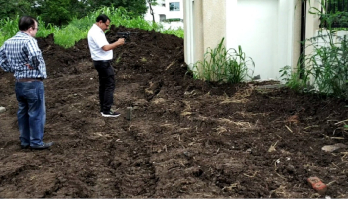
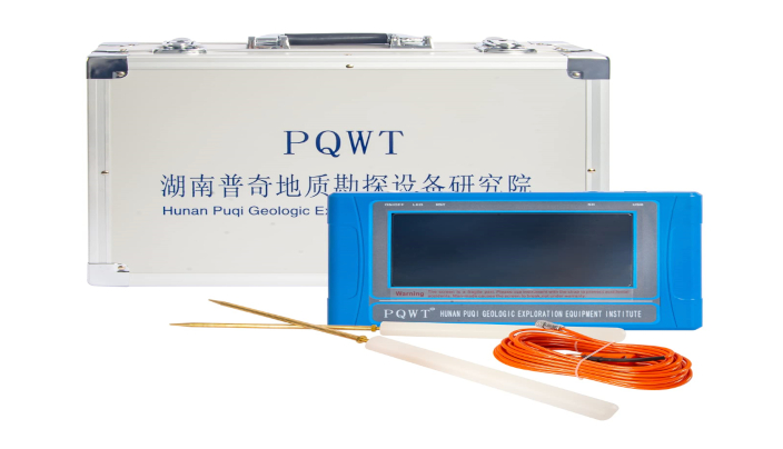
The Aravalli mountain range, passing through Udaipur, Ajmer, and Alwar, consists of ancient metamorphic rocks like quartzites and schists. In such terrains, water is only found in tectonic fractures. Our specialized Ground Water Survey in Rajasthan for these regions utilizes the PQWT multichannel detector. This device creates a 2D vertical profile of the ground, showing exactly where the rock is broken and saturated with water. Without this level of detail, a borewell might miss the water-bearing vein by just a few feet.
In the western districts like Bikaner and Jaisalmer, the challenge is the depth and salinity. A comprehensive Ground Water Survey in Rajasthan helps in distinguishing between fresh water lenses and saline aquifers. We provide data on the expected depth of the water table, which in some parts of Rajasthan can be as deep as 800 to 1200 feet. Scientific mapping prevents the mistake of drilling into "brackish" water zones, saving you from a lifetime of plumbing issues.
Saving Drilling Costs through Ground Water Survey in Rajasthan
The cost of drilling in Rajasthan has skyrocketed due to the depth required and the hardness of the strata. A single failed borewell can cost between ₹1.5 lakh to ₹4 lakhs. Spending a small fraction of that on a professional Ground Water Survey in Rajasthan is the smartest investment you can make. Our survey report includes details on soil thickness, bedrock depth, and water yield estimation (GPH). This allows you to choose the right drilling rig—whether DTH or Rotary—before the machine even arrives at the site.
Industrial Standards for Ground Water Survey in Rajasthan
For industrial units in RIICO areas, water is a critical raw material. To obtain a CGWA (Central Ground Water Authority) NOC, a technical hydrogeological report is mandatory. Our Ground Water Survey in Rajasthan provides the empirical data needed for these legal submissions. We have worked with major manufacturing units to pinpoint high-volume tubewell points that support continuous production cycles while ensuring compliance with state water regulations.
Our Proven Survey Methodology
At Bhoojal Survey, every project for Ground Water Survey in Rajasthan follows a strict 5-step scientific protocol:
Geological Reconnaissance: Studying the local rock outcrops and slope to understand natural recharge patterns.
Geophysical Grid Setup: Laying out sensors across your land to scan the subsurface from multiple angles.
Data Acquisition: Capturing resistivity values and electromagnetic signals from depths of up to 1500 feet.
Interpretation: Senior hydrogeologists analyze the frequency curves to find the point of maximum saturation.
Marking & Reporting: Pointing out the exact drilling spot and providing a technical strata report.
FAQs: Ground Water Survey in Rajasthan
What is the success rate of Ground Water Survey in Rajasthan?
While no scientific method is 100% (due to unpredictable nature), our Ground Water Survey in Rajasthan provides a success rate of over 90-95%, which is significantly higher than traditional dowsing.
How much time does it take for a Ground Water Survey in Rajasthan?
A standard residential survey takes about 2-3 hours, whereas industrial sites may take 1-2 days for complete mapping.
Can you detect water in the desert areas of Rajasthan?
Yes, we use specific low-frequency instruments for sandy terrains during a Ground Water Survey in Rajasthan to find deep paleo-channels.
Do I get a written report after the Ground Water Survey in Rajasthan?
Yes, we provide a detailed technical report including the suggested drilling depth, casing size, and strata analysis.