Hydrological Survey & Hydrographic Survey — Expert Water Detection
Bhoojal Survey offers India's most advanced hydrological survey and bhoojal survey services using SSRMPATS, GER Detect, and PQWT instruments. Locate groundwater accurately with a site-specific scientific survey — before you drill a single metre.
[ Rated 4.9 by more than 500+ Customers Globally ]
24+
Team Members
12+
Sector Expertise
1170+
Happy Clients


Book Hydrological Survey Today
A professional groundwater survey backed by a scientific hydrological survey is the most reliable way to locate underground water before drilling a borewell. Drilling without a proper bhoojal survey is one of the costliest mistakes a landowner can make. A hydrological survey eliminates that risk completely — it gives you scientific data about what lies beneath your land before you spend a single rupee on drilling. Whether you are a farmer, builder, or homeowner, a bhoojal survey backed by hydrological science is your best investment.
What is a Hydrological Survey and Why is it Critical for Site-Specific Planning?
A hydrological survey is a scientific study of water movement, distribution, and availability in a given area. It examines surface water, groundwater, rainfall patterns, and subsurface conditions to create a complete picture of water resources beneath and around your land.
A bhoojal survey applies these same hydrological principles at the field level. It is site-specific — meaning every survey is tailored to your exact plot, your local topography, and your regional geology.
Understanding the Hydrological Cycle in Your Region
The hydrological cycle describes how water moves from precipitation to surface water bodies, then into the ground through infiltration and groundwater recharge. Understanding this cycle is essential before any bhoojal survey begins.
In arid and semi-arid regions like Madhya Pradesh, rainwater infiltration is limited. This makes a proper hydrological survey even more critical — because aquifer zones are fewer, deeper, and harder to locate without scientific tools.
Why Surface and Subsurface Analysis is Necessary Before Drilling
Before you drill, our team analyses both standing water conditions and sub-surface geology. We evaluate soil layers, rock formations, drainage patterns, and land use history. This combined analysis is what makes a bhoojal survey far more reliable than any traditional guessing method.
A topographic analysis of your land is also performed. This helps us understand how water flow moves across and into the ground — and where it accumulates underground.
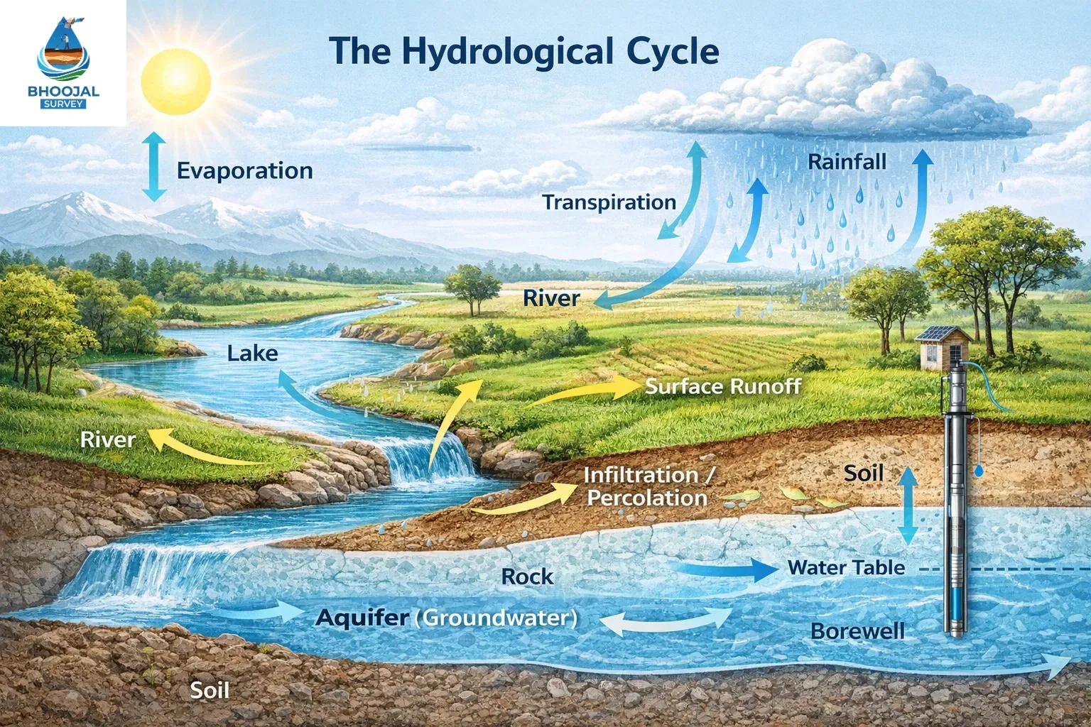
Understanding the hydrological cycle is the foundation of every scientific bhoojal survey
Hydrological vs. Hydrogeological Survey: Clearing the Confusion
A hydrological survey studies water at the surface and atmospheric level — including stream flow, water levels, catchment areas, and precipitation data. A hydrogeological survey goes deeper — it focuses on groundwater, aquifer depth, rock permeability, and subsurface water movement.
A complete bhoojal survey combines both. Our team studies surface watercourses, inflow patterns, and then digs deeper into groundwater behaviour using advanced instruments.
When to Choose Hydrogeological Mapping for Borewells
If your goal is borewell success, hydrogeological mapping is essential. It identifies the exact aquifer zone, estimates water depth, and predicts water yield. Our bhoojal survey includes full hydrogeological mapping as a standard component — not an optional add-on.
Our experts specialise in conducting hydrogeological survey using SSRMPATS Instrument, GER DETECT, and PQWT at site for open well / borewell location to ensure the highest success rate in the industry.
Book a Scientific Bhoojal Survey Before You Drill
Our certified hydrological survey team covers 18+ cities across India. Get a complete groundwater detection report within 48 hours of survey completion.
Call Now: +91-9691858058 View Survey ServicesThe Role of Hydrographic Survey in Deep Water Body Management
A hydrographic survey measures and maps water bodies — including rivers, lakes, reservoirs, and coastal zones. It uses depth soundings, bathymetric data, and nautical charts to create accurate underwater maps. For large-scale projects near rivers or dams, a hydrographic survey is mandatory.
Bathymetry — the science of measuring water depth in water bodies — is a core part of hydrographic work. It helps engineers understand sediment accumulation, silt buildup, and deep water zones. Hydrographic data is also used in flood risk assessment and dam safety planning.
How a Professional Hydrological Survey Works: The Scientific Process
Every bhoojal survey follows a structured scientific process. Our surveyor team begins with data collection — gathering meteorological records, rainfall history, land use maps, and previous borewell data in your area.
Advanced Sub-surface Investigation Techniques
Our hydrological survey uses advanced sub-surface investigation methods. The resistivity test sends electrical signals into the ground and measures how different layers respond. Geological variations in soil and rock create distinct resistance patterns — allowing us to map underground water zones with precision.
We also use interpolation techniques to fill data gaps between scan points, creating a smooth and accurate data set of your entire plot. This data collection process forms the scientific backbone of every bhoojal survey we conduct.
Creating a Digital Terrain Model for Better Accuracy
A digital terrain model (DTM) is created using geo-referenced scan data and topographical information. This model shows the exact shape of underground layers — including aquifer zones, dry rock formations, and sediment layers.
ArcGIS and HEC-RAS are among the software tools we use to process raw data and generate accurate underground maps. The coordinate system used ensures every borewell point marked on your land is precisely located — with zero margin for error.
Advanced Technology: From SSRMPATS to High-Precision Sensors
Our bhoojal survey uses the world's best instruments. These are the same tools used in offshore oil exploration, geodetic surveys, and hydrographic community research worldwide. We bring that same level of precision to your borewell project.
The Power of PQWT and GER DETECT in Deep Water Detection
The PQWT machine creates a digital terrain model of underground water layers. It uses swath scanning to cover wide areas quickly. Its mobile app interface provides real-time bathymetric data-style underground maps — similar to how a hydrographic survey charts watercourses.
The GER DETECT is built on advanced German technology. It is a long range water detection system capable of locating deep water aquifers at 200–300+ metres depth. It is used globally for navigational, industrial, and groundwater projects alike. It can even detect temperature and salinity variations in underground water — a feature that helps predict water quality before drilling.
Using SSRMPATS for Site-Specific Aquifer Identification
The SSRMPATS instrument is a powerful sub-surface scanner. It identifies aquifer zones, fault lines, and water-bearing fractures with high precision. Our bhoojal survey team uses it to deliver site-specific results — customised to your exact land, your local topography, and your regional geological conditions.
AUVs (Autonomous Underwater Vehicles) and unmanned systems are now being integrated into advanced hydrographic surveys globally. Our team stays current with these developments to continually improve our bhoojal survey methods.
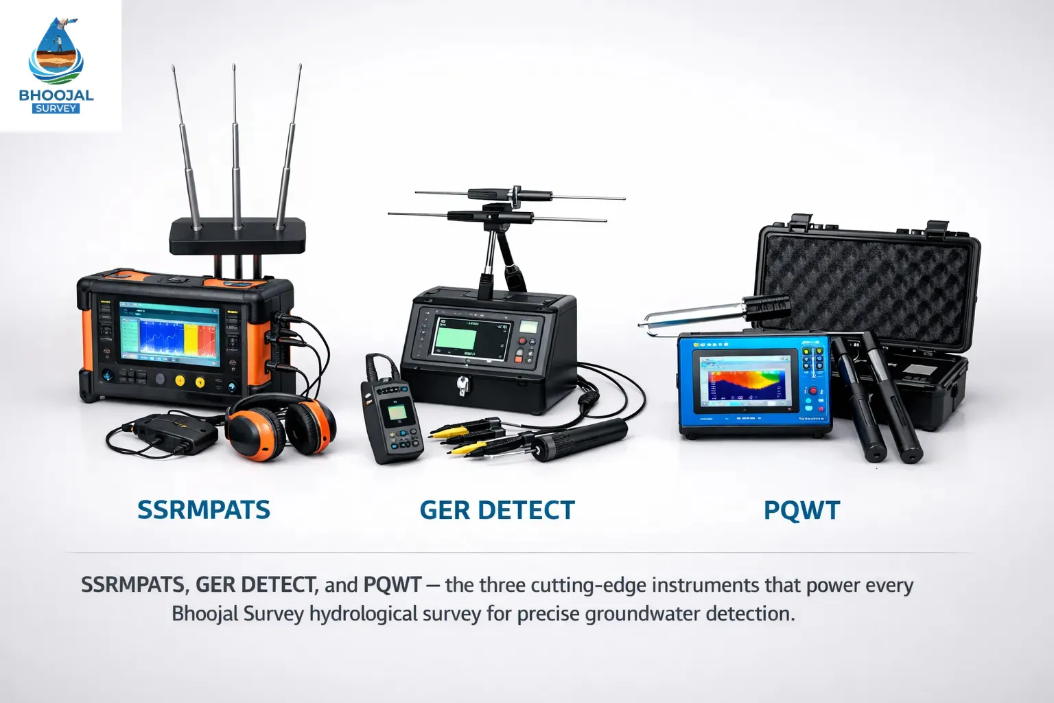
SSRMPATS, GER DETECT and PQWT — the three instruments that power every Bhoojal Survey hydrological survey
Comprehensive Risk Assessments: Avoiding Borewell Failures
Identifying Geological Risks Before the Project Starts
Every bhoojal survey includes a full risk assessments phase. We identify dry zones, hard rock barriers, and weak aquifer areas before your driller arrives. This prevents costly failures and protects your investment completely.
flood hazard risk is also analysed during this phase. Understanding flood risk assessment data helps us identify areas where groundwater recharge is high — making those zones ideal for borewells with long-term yield potential.
Analysing Sediment Layers and Rock Formations
Sediment analysis is a critical part of our hydrological survey process. Layers of silt, clay, and sand affect how water moves underground. Heavy sediment deposits can block water flow and reduce borewell yield significantly.
Our team analyses each sediment layer and rock formation to assess water movement velocity and storage potential. This gives you a complete picture of what lies beneath — and exactly where to drill for the best results.
Hire Expert Hydrological Survey Team Near You
Avoid costly dry borewells. Our scientific bhoojal survey identifies the exact aquifer point on your land before drilling begins.
Call Now: +91-9691858058 Underground Water DetectorWhy Hydrographic Survey is Essential for Large-Scale Projects
Mapping Subsurface Water Structures in Rivers and Dams
For projects near rivers, reservoirs, or dams, a hydrographic survey is essential. It maps water bodies, measures water depth, and analyses water flow patterns. Chart data from these surveys is used by engineers, government agencies, and the environment agency to plan infrastructure safely.
Our bhoojal survey team can integrate hydrographic data into your groundwater project — giving you a complete picture of both surface water and underground conditions.
Assessing Sediment Accumulation in Deep Water Reservoirs
Sediment accumulation in reservoirs reduces storage capacity over time. Dredge operations are planned based on bathymetric data and hydrographic survey results. Our team uses depth soundings and swath mapping to chart the exact location and volume of silt deposits — helping reservoir managers plan dredge operations efficiently.
Water resource management depends heavily on accurate hydrographic data. Without it, planners cannot predict water levels, manage inflow, or protect natural resources effectively.
Top 5 Benefits of a Professional Scientific Survey
Cost-Saving Through Precise Point Marking
- Avoid dry borewells — our bhoojal survey identifies exact water zones before drilling
- Reduce drilling costs — know the precise depth before you drill
- Map multiple water zones across large plots in a single visit
- Water quality analysis included — know what you are getting before drilling
- Groundwater levels and yield estimates provided in every report
Long-Term Sustainability of Your Water Source
A proper hydrological survey does not just find water today. It analyses groundwater recharge rates, rainfall patterns, and basin hydrology to ensure your borewell remains productive for years. Our bhoojal survey report includes long-term water resource management recommendations — so your water source stays reliable season after season.
Who Needs These Specialised Services?
Farmers & Landowners: Finding the Best Borewell Point
Farmers across India depend on reliable groundwater for irrigation. A bhoojal survey using a professional hydrological survey process helps every farmer — from small 1-acre plots to large agricultural operations — find the best borewell point with confidence. Our groundwater survey service has helped thousands of farmers avoid dry borewells and protect their livelihoods.
Builders & Industries: Ensuring CGWA Compliance and Legal Safety
For commercial and industrial projects, a hydrological survey is not just useful — it is often legally required. The Central Ground Water Authority (CGWA) mandates NOC permissions for commercial groundwater extraction. Our bhoojal survey report provides the scientific data set required for CGWA applications — ensuring your project stays legally compliant.
Land use planning, water-related risk management, and sub-surface investigation reports are all part of our commercial survey package.
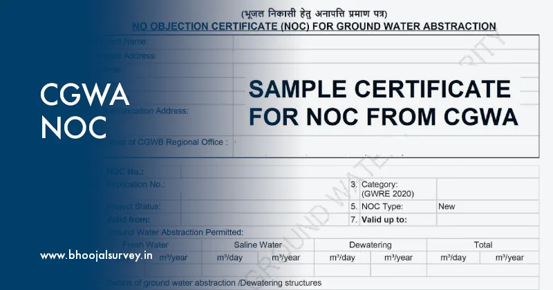
Our hydrological survey report meets full CGWA NOC compliance requirements for industrial and commercial projects
Frequently Asked Questions About Hydrological Survey
1. What is a hydrological survey?
A hydrological survey is a scientific study of the distribution, movement, and quality of water both above and below the earth's surface. In the drilling industry, it is primarily used to map aquifers and locate the most productive points for a borewell or open well.
2. How is a hydrological survey done?
The process involves a site-specific field investigation. Experts use geophysical methods like Vertical Electrical Sounding (VES). Electrodes are used to send currents into the ground to measure resistivity, which helps in identifying water-bearing rock formations (aquifers) and sediment layers.
3. What is the difference between a hydrological and hydrogeological survey?
While often used interchangeably, a hydrological survey focuses on the overall water cycle (including surface water like rivers), whereas a hydrogeological survey specifically studies how water moves through soil and rock layers underground. For borewell point selection, a hydrogeological approach is more common.
4. Why is a hydrological survey essential before drilling?
It is essential because it eliminates the risk of a "Dry Borewell." A scientific survey provides data on the exact depth of the water table and the potential yield. Additionally, it is a mandatory requirement for obtaining a CGWA NOC for industrial and commercial projects.
5. How does a hydrological survey work?
It works on the principle of electrical resistivity. Since water conducts electricity differently than solid rock or dry soil, advanced machines like PQWT or SSRMPATS can create a subsurface map. This data is then used to generate a Digital Terrain Model to identify the best drilling location.
6. What are the three types of water-related surveys?
The three main types include: Geophysical Survey — mapping subsurface rock and soil structures; Hydrogeological Survey — locating underground water sources and aquifers; Hydrographic Survey — mapping the physical features of underwater areas like rivers, lakes, or oceans.
7. What is a hydrological assessment?
A hydrological assessment is a detailed evaluation of the water resources in a specific area. It includes risk assessments regarding water availability, sustainability, and the impact of a new borewell on the local environment. It is often required for large-scale construction and industrial permits.
8. Can a hydrological survey detect deep water aquifers?
Yes. Using advanced instruments and deep-earth resistivity tests, surveyors can detect water at significant depths (sub-surface). This ensures that the drilling reaches a sustainable aquifer that won't go dry during the summer months.
9. What are the risks of skipping a scientific survey?
Skipping a survey leads to "Guesswork," which often results in drilling in the wrong location, hitting dry patches, and losing lakhs of rupees in failed drilling costs. Scientific analysis provides a 95% success rate compared to traditional methods.
10. Who needs professional hydrological survey services?
Farmers: To find high-yield points for irrigation. Industrialists: For legal compliance (CGWA) and factory water supply. Builders: For site-specific water management in housing societies. Landowners: To ensure a lifetime of reliable water for residential use.
Conclusion: Secure Your Investment with Data-Driven Water Detection
Water is your most valuable natural resource — and a failed borewell is one of the most avoidable losses in land development. A professional bhoojal survey backed by a full hydrological survey process gives you complete confidence before you drill.
From sub-surface scanning and sediment analysis to digital terrain model creation and groundwater mapping — our team covers every aspect of scientific water detection. We use the worlds best instruments, proven software tools like ArcGIS and HEC-RAS, and decades of field expertise to deliver results you can trust.
Don't let your investment go dry. Book a scientific hydrological survey and bhoojal survey today — and guarantee your water source.
Scheme No. 114, Part-2, Indore, Madhya Pradesh – 452010, India
Phone: +91-9691858058
Email: [email protected]
Website: www.bhoojalsurvey.in
Hours: Monday – Saturday, 9:00 AM to 6:00 PM IST
Don't Drill Blind — Book Your Hydrological Survey Today
Bhoojal Survey's expert team brings world-class hydrological and hydrographic survey technology to your doorstep. One survey. One accurate borewell point. Zero guesswork.
Call +91-9691858058 Now Book Survey Online View All Survey Services