Ground Water Survey Experts
Providing the most reliable Ground Water Survey in Neemach to help you locate high-yield borewell points. We use scientific geophysics for 100% accurate results in the Malwa region.
[ Rated 4.9 by more than 4500+ Customers Globally ]
Team Members
Sector Expertise
Our Happy Clients
We have worked with India’s Greatest Companies Since 2001


Top Rated
Leading Professional Ground Water Survey in Neemach


Lowest Fee
Most Affordable Consulting Fees Rate in Madhya Pradesh

Trusted Experts
Best Hydrogeological Consulting Firm in Central India
Scientific Approach to Ground Water Survey in Neemach
Locating water in the hard-rock basaltic terrain of the Malwa region requires a deep understanding of subsurface geology. When residents or industrial developers seek a reliable Ground Water Survey in Neemach, they are essentially looking for a guarantee that their borewell investment will yield results. Neemach, with its unique structural features and fluctuating water tables, presents a challenge that traditional "water diviners" simply cannot solve. At Bhoojal Survey, we combine decades of field experience with high-tech geophysical instrumentation to identify the exact location of water-bearing fractures.
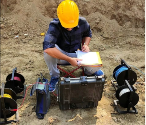
A professional Ground Water Survey in Neemach involves mapping the aquifer zones and understanding the weathered rock patterns. The city and its surrounding tehsils like Jawad and Manasa sit on hard rock layers where water is trapped in deep-seated cracks. If you drill just a few feet away from these cracks, your borewell will likely go dry. Our team utilizes Multi-channel Resistivity and PQWT curves to create a visual map of the earth before a single inch of soil is excavated.
Technical Analysis of Neemach Hydrogeology
The ground beneath the Malwa plateau is primarily composed of the Deccan Trap basalts. In our extensive experience providing Ground Water Survey in Neemach, we have found that the water potential depends on the thickness of the "weathered zone" and the presence of primary or secondary porosity. Our geologists analyze lithological maps to understand the strata details. This scientific data helps determine whether a DTH rig or a Rotary rig is suitable for your specific location.
Why a Professional Survey is Better than Traditional Methods
Many property owners in rural parts of Neemach still rely on dowsing with coconuts or sticks. While culturally significant, these methods lack empirical data. A technical Ground Water Survey in Neemach provides you with a comprehensive report including:
- ● Precise depth estimation to prevent over-drilling or under-drilling.
- ● Fracture zone identification to target high-yield aquifers.
- ● Soil resistivity mapping to understand the mineral content and strata hardness.
- ● Water yield prediction (Gallons per hour) based on aquifer thickness.
Latest Technology for Borewell Selection
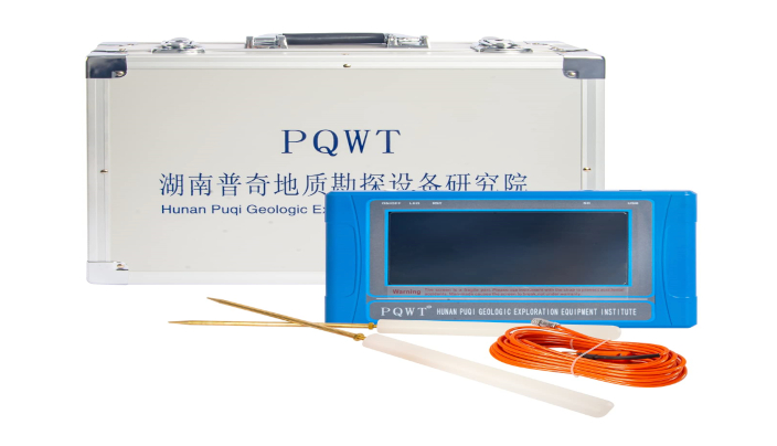
We pride ourselves on using the world's most advanced equipment. For every Ground Water Survey in Neemach, we deploy the GER Detect long-range system for initial scouting and the PQWT multichannel detector for pinpointing. The GER Detect system uses electrical resistivity principles to locate anomalies deep within the earth, distinguishing between fresh water and saline water zones. This is crucial for farmers in the Neemach-Mandsaur belt who need sweet water for irrigation.
Industrial and Agricultural Solutions
Neemach is an agricultural powerhouse, famous for its Krishi Mandi and production of medicinal crops like Ashwagandha. For farmers, a Ground Water Survey in Neemach is a life-changing service. It allows them to plan their crop cycles with confidence, knowing their water source is stable. For industries in the industrial areas of Neemach, our surveys are a prerequisite for obtaining CGWA (Central Ground Water Authority) NOCs. We provide the mandatory hydrogeological reports required for legal groundwater withdrawal.
The Process of a Field Survey
When you book a Ground Water Survey in Neemach with us, our team follows a rigorous 5-step process:
- Reconnaissance: Initial site inspection to understand the slope and natural recharge patterns.
- Instrument Grid Setup: Placing electrodes and sensors in a scientific grid across your land.
- Data Acquisition: Recording electromagnetic signals and resistance values from various depths.
- Interpretation: Analyzing the "curves" and "graphs" to find anomalies where water is present.
- Marking: Pinpointing the exact center of the fracture zone on the ground for the driller.
By investing in a scientific Ground Water Survey in Neemach, you are essentially buying peace of mind. A borewell in Neemach can cost anywhere from ₹1 lakh to ₹5 lakhs depending on the depth and casing. Spending a small fraction on a survey ensures that your lakhs of rupees do not go to waste in a dry hole.
Sustainable Groundwater Management
At Bhoojal Survey, we don't just find water; we encourage conservation. After conducting a Ground Water Survey in Neemach, we often advise our clients on Rainwater Harvesting (RWH) techniques. Recharging the same aquifer that you extract from is the only way to ensure water security for the next generation. Neemach’s water table is sensitive, and scientific extraction combined with recharge is the path forward.
Expertise of Bhoojal Survey Team
At Bhoojal, our expert team of geologists and hydrogeologists brings years of experience in groundwater exploration, monitoring, and data analysis. Through extensive field knowledge and cutting-edge technology, we consistently deliver the most accurate and reliable results across Neemach and Indore. Our dedicated professionals ensure that each Ground Water Survey in Neemach meets the highest standards, providing actionable insights for sustainable groundwater management.
FAQs: Ground Water Survey in Neemach
What is an underground water survey?
An underground water survey is a scientific process that uses geophysical techniques and geological assessments to locate and assess subterranean water resources.
How do you test groundwater?
Groundwater is tested through sampling and laboratory analysis to determine its quality, including pH, contaminants, and mineral content.
What is a geophysical survey for groundwater?
A geophysical survey for groundwater employs methods like electrical resistivity, seismic waves, and magnetic fields to map underground water formations without drilling.
What are the methods of water survey?
Methods include geophysical surveys, drilling exploratory wells, hydrological mapping, and remote sensing technology.
What are the two types of underground water?
The two types are confined aquifers, where water is trapped between layers of impermeable material, and unconfined aquifers, where water seeps from the ground surface directly above it.
What Our Clients Say
The Ground Water Survey in Neemach helped us find water at 450 feet after two failed borewells. Truly professional!
Raman Arora
AgriculturistMost accurate borewell detection in Neemach. They explain the strata details very clearly. Highly recommended.