At Bhoojal Survey we conduct Hydrological Survey, Drainage Analysis and Flood Risk Assessment studies for industrial, infrastructure, airport, solar, mining, and commercial projects across India. Our team has worked on hydrology and flood modelling projects involving rainfall analysis, runoff estimation, watershed delineation, flood inundation studies, and drainage planning for various site conditions.
The hydrological study is carried out to understand rainfall runoff, natural drainage patterns, catchment characteristics, stormwater flow, and flood potential within the project area. These studies play an important role in site planning, drainage design, flood mitigation, and environmental assessment.
Our experience includes hydrology studies for solar plants, industrial developments, airport drainage systems, and flood modelling projects using topographical analysis, rainfall data interpretation, DEM assessment, watershed analysis, and hydrological modelling approaches.
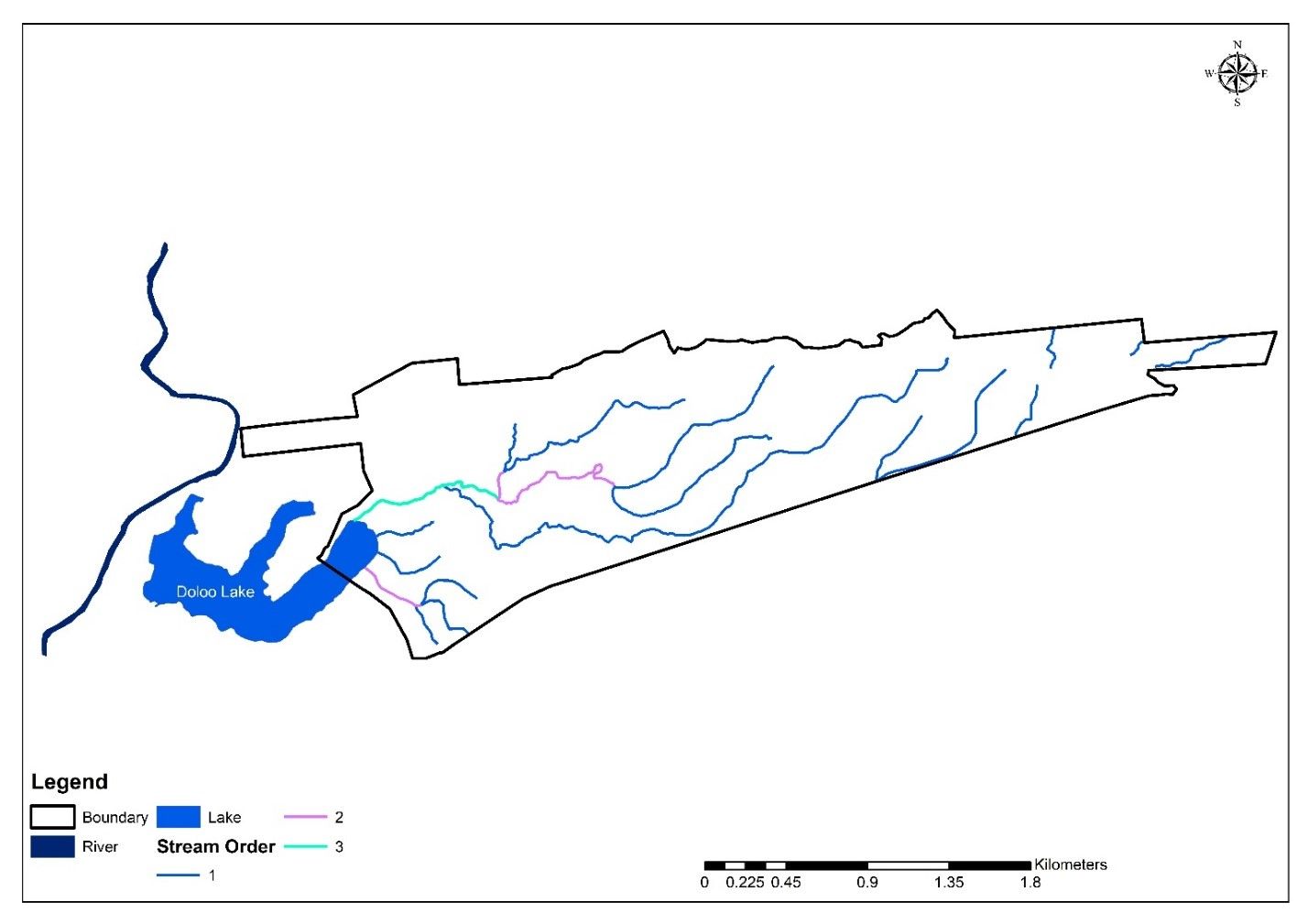
Stream Order
Methodology of Hydrological Survey
Site Inspection & Field Assessment
Collection of Rainfall & Topographical Data
Catchment & Watershed Delineation
Drainage & Stream Network Analysis
Runoff & Stormwater Assessment
Flood Risk & Inundation Analysis
Hydrological Modelling & Report Preparation
1. Site Inspection & Field Assessment
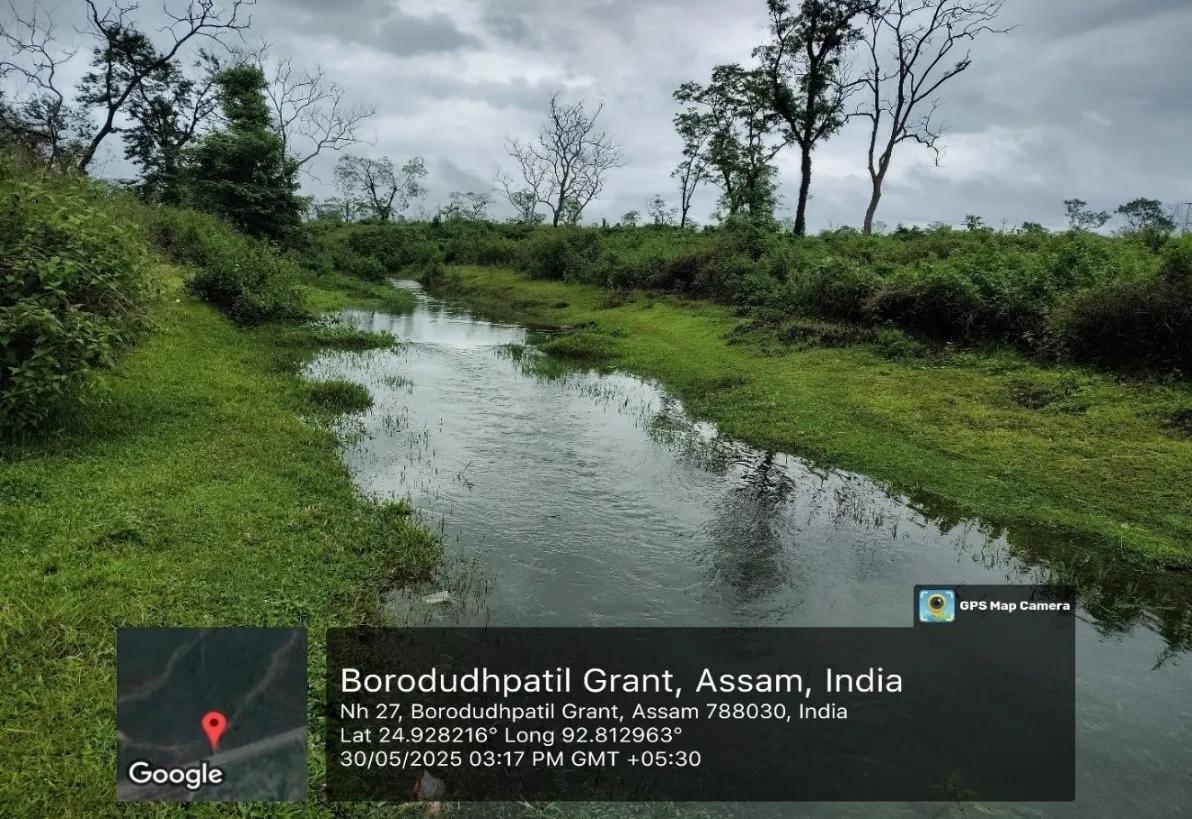
The hydrological survey begins with a detailed site inspection to understand the existing terrain conditions, natural drainage patterns, streams/nalas, low-lying areas, water accumulation zones, and surrounding catchment characteristics. Field observations are carried out to assess surface water movement, slope conditions, existing drainage paths, and flood-prone locations within and around the project site.
Site inspection
2. Collection of Rainfall & Topographical Data
Historical rainfall data is collected from IMD, local meteorological departments, and other reliable sources to understand rainfall patterns, runoff conditions, and flood potential of the project area. Rainfall analysis is carried out for different return periods as required for hydrological and flood risk studies.
Topographical and contour data of the site is analysed to study surface slope, drainage flow, low-lying areas, and natural water movement within the project area. This data plays an important role in catchment delineation, runoff estimation, drainage analysis, and hydrological modelling.
Historical rainfall data analysis carried out for hydrological and flood risk assessment studies.
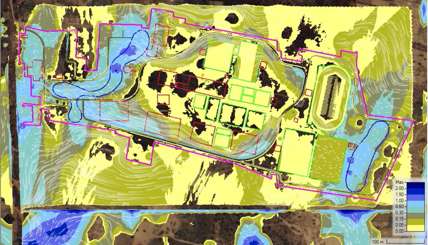
3. Catchment & Watershed Delineation
Catchment and watershed analysis is carried out to understand the movement of surface water within and around the project area. Using contour data, DEM analysis, satellite imagery, and terrain interpretation, drainage flow directions, stream networks, watershed boundaries, and contributing catchment areas are identified.
This assessment helps in understanding runoff generation, drainage behavior, external water inflow, and flood contribution from surrounding areas. Stream order mapping and watershed delineation also play an important role in drainage planning, flood risk assessment, and hydrological modelling studies.
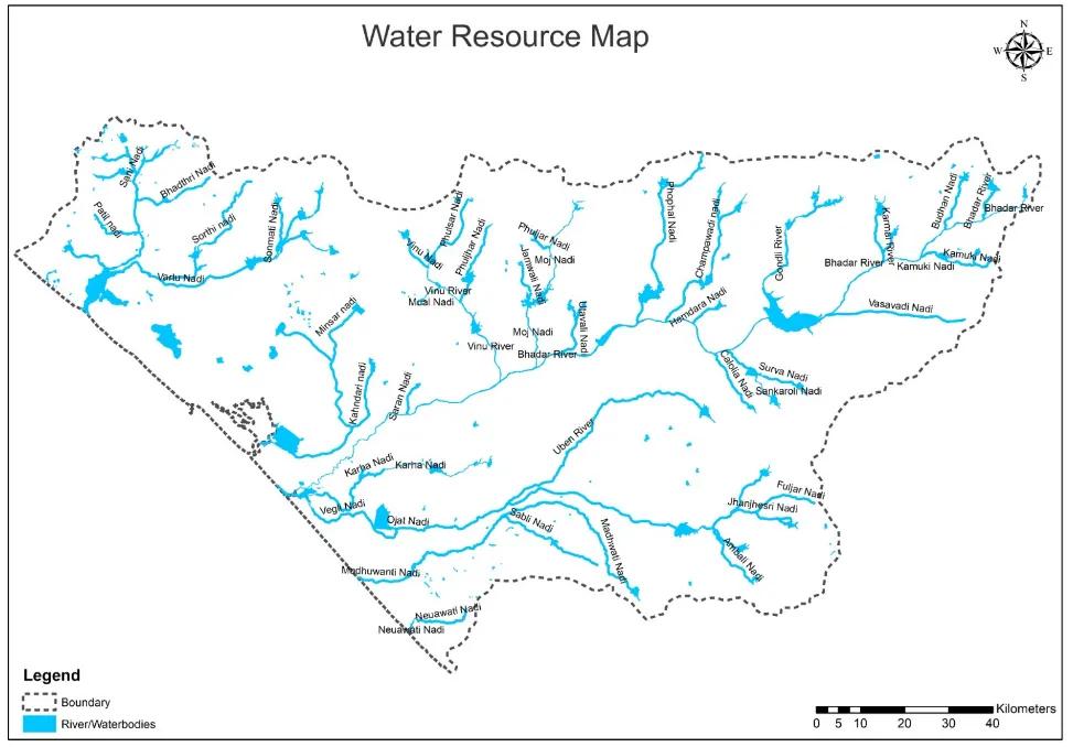
Water resource and drainage
4. Drainage & Runoff Analysis
Drainage and runoff analysis is carried out using topographical survey data, DEM analysis, catchment characteristics, and historical rainfall records collected for the project area. Surface slope, drainage flow direction, runoff accumulation zones, and discharge points are analysed to understand the drainage behavior of the site.
Historical rainfall data is analysed to prepare Intensity-Duration-Frequency (IDF) curves and estimate rainfall intensity for different return periods including 25-year, 50-year, and 100-year return period rainfall events. Catchment area, runoff coefficient, land use characteristics, slope conditions, and time of concentration are evaluated for hydrological assessment and runoff estimation.
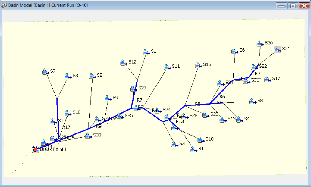
Hydrological modelling using HEC-HMS, HEC-RAS, MIKE FLOOD, TUFLOW, XP-STORM, and similar hydrological and hydraulic modelling software is carried out to estimate peak runoff, runoff hydrographs, flood discharge, and stormwater flow under extreme rainfall conditions. The analysis helps in flood risk assessment, drainage planning, flood mitigation studies, and identification of critical water accumulation zones within the project area.
HEC-HMS basin model
5. Flood Risk & Inundation Analysis
Flood risk and inundation analysis is carried out to assess the impact of extreme rainfall events, surface runoff, river/nala overflow, and external catchment contribution within the project area. The study helps in identifying flood-prone zones, water accumulation areas, flow paths, and critical low-lying regions susceptible to flooding during high-intensity rainfall conditions.
Hydraulic and hydrodynamic modelling using HEC-RAS, MIKE FLOOD, TUFLOW, XP-STORM, and similar flood modelling software is carried out for different return periods including 25-year, 50-year, and 100-year return period flood events. Flood inundation maps, flood depths, flow velocity, and water surface elevations are analysed to understand flood behavior within and around the project site.
The analysis also helps in identifying suitable drainage outfall locations, flood mitigation measures, and stormwater management requirements for safe project planning and infrastructure development.
water depth analysis
6. Hydrological Study Deliverables
The final hydrological study report includes detailed assessment of rainfall runoff, drainage behavior, catchment characteristics, and flood risk within the project area. The report is prepared using field observations, topographical analysis, rainfall interpretation, and hydrological modelling outputs.
Typical deliverables include:
Catchment & watershed maps
Drainage network analysis
Rainfall analysis and IDF curves
Peak runoff estimation
Flood inundation maps
Water depth and flow direction analysis
Highest Flood Level (HFL) assessment
Stormwater drainage recommendations
Flood mitigation measures
Hydrology & flood risk assessment report
Hydrological surveys mainly deal with surface water flow, drainage behavior, rainfall runoff, and flood assessment within a catchment area. Hydrogeological surveys focus on groundwater occurrence and aquifer investigation for borewell and groundwater exploration studies. Hydrographic surveys are generally conducted in rivers, lakes, reservoirs, ports, and coastal regions for underwater mapping and navigation purposes.
Hydrological Survey and Flood Risk Assessment for Solar Plant Site – Sangli, Maharashtra
Hydrological Study and Flood Modelling for Airport Project – Silchar, Assam
Post Development Hydraulic Analysis for Infrastructure Site – Bihar
Hydrological Survey and Flood Modelling for Road Project Low-Lying Areas – Gujarat
Peak Flood Risk Assessment for Agricultural Land Near River – Madhya Pradesh
Hydrological Survey and Drainage Recommendations for Industrial Project – Amravati, Maharashtra
Watershed Delineation and Runoff Analysis for Solar Power Project – Rajasthan
Flood Inundation Mapping and Stormwater Assessment for Industrial Development – Chhattisgarh
Drainage Analysis and Hydrological Modelling for Township Development Project – Uttar Pradesh
Catchment Area Analysis and Surface Water Assessment for Mining Project – Odisha
Software & Tools Used
Industry-standard hydrological, hydraulic, GIS, and terrain analysis software are used for hydrological modelling, runoff estimation, drainage analysis, and flood risk assessment.
Hydrological surveys and flood risk assessment studies are widely used for:
Solar Power Projects
Industrial & Manufacturing Projects
Roads & Highway Developments
Airport & Infrastructure Projects
Mining & Quarry Areas
Railway Projects
Residential & Township Developments
Stormwater Drainage Planning
Environmental & EIA Studies
Flood-Prone & Low-Lying Areas
River & Nala Flood Assessment
Site Development & Land Planning
Why Choose Bhoojal Survey & Consultants
Experienced hydrology & flood modelling team
Industry-standard software and analysis
Site-specific drainage and runoff assessment
Hydrological studies for industrial & infrastructure projects
GIS, DEM, and watershed-based analysis
Detailed technical reporting and flood assessment
Our services include Hydrological Survey, Hydrological Study, Flood Modelling, Drainage Analysis, Watershed Delineation, Flood Inundation Mapping, and Surface Water Assessment for industrial and infrastructure projects.
Contact Bhoojal Survey & Consultants for Hydrological Survey, Flood Risk Assessment, Drainage Analysis, Watershed Delineation, and HEC-HMS / HEC-RAS based hydrological modelling services across India.
Hydrological Survey Services Across India
We provide hydrological survey, flood risk assessment, drainage analysis, watershed delineation, and hydrological modelling services for industrial, infrastructure, solar, mining, and environmental projects across India.
Our team has executed hydrology and flood assessment studies in multiple states including Madhya Pradesh, Maharashtra, Gujarat, Assam, Rajasthan, Bihar, Chhattisgarh, Odisha, Uttar Pradesh, and other regions across India.
Frequently Asked Questions
What is a Hydrological Survey?
A hydrological survey is the study of rainfall runoff, drainage systems, surface water flow, catchment characteristics, and flood potential within a project area.
Why is Hydrological Survey important?
Hydrological surveys help in understanding drainage behavior, flood risk, runoff generation, and stormwater movement for safe project planning and infrastructure development.
What is a 100-Year Return Period?
A 100-year return period rainfall event represents an extreme rainfall condition having a 1% probability of occurring in any given year and is commonly used for flood risk assessment and drainage design.
Which software is used for Hydrological & Flood Modelling?
Software such as HEC-HMS, HEC-RAS, MIKE FLOOD, TUFLOW, ArcGIS, and QGIS are commonly used for hydrological modelling, runoff estimation, and flood inundation analysis.
What is an IDF Curve?
An Intensity-Duration-Frequency (IDF) curve represents the relationship between rainfall intensity, rainfall duration, and return period, and is widely used for runoff estimation and drainage design.
What are the major deliverables of a Hydrological Study?
I recently used the soil resistivity website and was impressed with the accuracy and ease of use of the tools provided. The site helped me to accurately measure the resistivity of the soil on my property and provided me with all the necessary information I needed for my project. I highly recommend this site to anyone looking for reliable soil resistivity data.
Raman Arora
Geotechnical Engineer
Bhoojal Survey website is a game-changer for our business. I recently used the earth resistivity testing services provided by Bhoojal Survey, and I must say I was thoroughly impressed. The website was easy to navigate and provided all the information I needed to understand the testing process and the benefits it could provide for my business.
Vivek Agrawal
Environmental Scientist
I recently had to obtain a NOC from CGWA for groundwater extraction, and I must say that the process was made extremely simple and efficient thanks to the team at Bhoojal Survey. The website provided all the necessary information, and the team was always available to answer any questions I had throughout the process.