Geo Hydrological Survey — Find Water Before You Drill
Bhoojal Survey offers India's most advanced geo hydrological survey services using SSRMPATS, GER Detect, and PQWT instruments. Locate groundwater accurately with a site-specific scientific survey — and get the exact borewell drilling point before spending a single rupee on drilling.
[ Rated 4.9 by more than 4500+ Customers Globally ]
24+
Team Members
12+
Sector Expertise
1170+
Happy Clients


Book Geo Hydrological Survey Today
A professional groundwater survey backed by a scientific geo hydrological survey is the most reliable way to locate underground water before drilling a borewell. Drilling without a survey is one of the costliest mistakes a landowner can make — over 30% of unsurveyed borewells in India fail completely. This scientific process eliminates that risk entirely. It gives you precise data about what lies beneath your land before you spend a single rupee on drilling. Whether you are a farmer, builder, or homeowner, booking a professional borewell survey is your best investment before any borewell project.
What is Geo Hydrological Survey and Why is it Critical?
A geo hydrological survey is a scientific study of underground water — combining geology (the study of rock formations and soil layers) with hydrology (the study of water movement and storage) to create a complete subsurface water map of your land.
It examines sub-surface geology, groundwater depth, aquifer zones, rainfall infiltration patterns, and water-bearing rock fractures — giving you a complete picture of what is underground before any drilling machine arrives at your site.
Understanding Geology and Hydrology Together
The hydrological cycle describes how water moves from rainfall to surface bodies, then into the ground through infiltration and groundwater recharge. Understanding this cycle at your specific site is the foundation of every scientific borewell survey we conduct.
In arid and semi-arid regions like Madhya Pradesh, Rajasthan, and parts of Maharashtra, rainwater infiltration is limited. Aquifer zones are fewer, deeper, and harder to locate without scientific instruments — making professional underground water detection even more critical in these regions.
Simple Breakdown: What "Geo Hydrological" Means
- "Geo" — Earth and ground: rock types, soil layers, fractures, and underground geological structure
- "Hydro" — Water: how groundwater moves, collects, and sits in aquifer zones underground
- "Logical" — Based on data, instruments, and science — not guesswork or tradition
Why Surface and Subsurface Analysis is Both Necessary
Before drilling, our team analyses both surface conditions and sub-surface geology. We evaluate soil layers, rock formations, drainage patterns, land use history, and topography. This combined surface-to-subsurface analysis is what makes our aquifer mapping process far more reliable than any traditional water-finding method.
A geo hydrological survey covers surface topography, geological mapping, and instrument-based subsurface scanning — all before drilling begins
Geo Hydrological vs. Hydrogeological Survey: Key Difference
A geo hydrological survey studies the complete water picture — surface drainage, rainfall infiltration, subsurface rock structure, and underground water movement — all together as an integrated system. A hydrogeological survey focuses more specifically on how water moves through soil and rock underground, with emphasis on aquifer characterisation and borewell yield estimation.
Our complete underground water survey from Bhoojal Survey combines both. Our team studies surface drainage patterns and inflow, then uses advanced instruments to map underground water behaviour — giving you the most complete water profile available for borewell site selection.
When to Choose Geo Hydrological Survey for Borewells
If your goal is borewell success, a geo hydrological survey with hydrogeological mapping is essential. It identifies the exact aquifer zone, estimates water depth, and predicts water yield. Our survey includes full hydrogeological mapping as a standard component — not an optional add-on.
Our experts specialise in conducting hydrogeological survey using SSRMPATS Instrument, GER DETECT, and PQWT at site for open well / borewell location — ensuring the highest success rate in the industry.
2026 Key Fact: Over 85% of India's rural drinking water and 60% of all irrigation depends on groundwater. With aquifer levels declining every year, a proper geo hydrological survey is no longer optional — it is essential for any borewell project in India today.
Book a Scientific Geo Hydrological Survey Before You Drill
Our certified geo hydrological survey team covers 18+ cities across India. Get a complete groundwater detection report within 48 hours of survey completion.
Call Now: +91-9691858058 View Survey ServicesAdvanced Instruments: SSRMPATS, GER Detect, and PQWT
Every geo hydrological survey by Bhoojal Survey uses the three most advanced instruments available in India for underground water detection. These are the same technologies used in offshore exploration and large-scale geophysical projects worldwide — delivered to your borewell site across India.
SSRMPATS — Deep Seismic Subsurface Profiling
The SSRMPATS (Surface Seismic Refraction and Multi-Point Array Tomography System) sends seismic signals into the earth and captures reflected signals to map underground rock layers with high precision. It is particularly powerful in complex geological zones where simpler resistivity methods give unclear results.
- Maps deep rock boundaries, fault lines, and fracture zones where water accumulates
- Works across all terrain — basalt, granite, mixed formations, deep confined aquifers
- Delivers site-specific depth profiles guiding exact drilling target selection
- Bhoojal Survey is among the very few water survey companies in India to use SSRMPATS on standard field projects
GER Detect — Electrical Resistivity Survey
The GER Detect instrument uses electrical resistivity to map underground water zones. Water-saturated rock and soil conduct electricity better than dry formations — zones with lower resistivity clearly indicate groundwater. Electrodes placed on the surface pass a controlled current into the ground, generating a full subsurface profile.
- Creates 2D and 3D underground maps showing depth and extent of water-bearing zones
- Effective across all Indian terrain — alluvial plains, basalt, granite, laterite, sandstone
- Entirely non-invasive — no digging, no damage to your property during the survey
- Globally validated and used in hydrogeological practice for over five decades
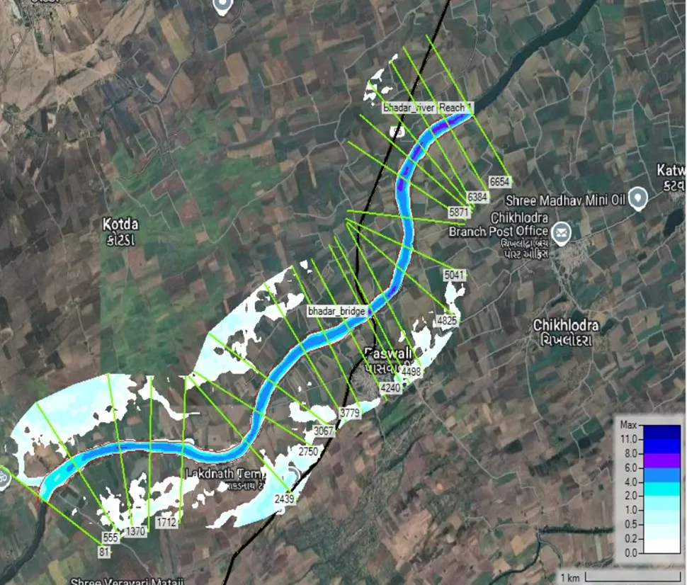
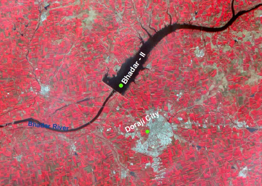
Watershed and drainage mapping used in geo hydrological survey to identify accurate borewell location and groundwater flow direction.
PQWT — NMR Direct Water Molecule Detection
The PQWT (Proton Quantity Water Detector) uses Nuclear Magnetic Resonance — the same principle as hospital MRI — to directly detect water molecules underground. Unlike resistivity methods that infer water from rock properties, PQWT detects actual hydrogen atoms inside water — giving direct confirmation of water presence and an estimate of water quantity before any drilling begins.
- Direct water detection — not inferred, but physically detected at the molecular level
- Estimates water quantity underground, predicting borewell yield before drilling
- Highly effective in hard rock terrain — granite and basalt — where narrow fractures hold water
- Fast field results — full underground water profile generated in hours on site
| Instrument | Method | Best For | Detects Quantity | Hard Rock Terrain |
|---|---|---|---|---|
| SSRMPATS | Seismic Tomography | Deep profiling, complex geology | Indirect | Yes |
| GER Detect | Electrical Resistivity | Wide-area mapping, all terrain | Indirect | Yes |
| PQWT | NMR | Direct detection + yield estimate | Yes — Direct | Yes |
| Schlumberger Array | Resistivity Array | Deep confined aquifer profiling | Indirect | Yes |
| Remote Sensing/GIS | Satellite Data | Large-area pre-survey screening | No | Yes |
Step-by-Step: How Our Geo Hydrological Survey Works
Every geo hydrological survey by Bhoojal Survey follows a strict scientific process — from pre-field remote analysis to final GPS borewell point marking and written report delivery. Here is exactly what happens when you book a survey.
- Free Consultation: Our hydrogeologist discusses your water requirement, site size, location, and intended use — drinking, irrigation, or industrial — to determine the correct survey approach.
- Remote Geological Pre-Study: Before visiting, we analyse satellite imagery, lithological maps, and regional geological data to improve field accuracy and reduce survey time on site.
- Site Reconnaissance: Our team visits your property and notes surface features — nearby wells, drainage patterns, rock outcrops, and land slope — to plan the best instrument deployment lines.
- Instrument Deployment: SSRMPATS, GER Detect, and PQWT are set up along planned survey lines covering multiple directions. Entirely on the surface — no digging, no damage to your land.
- Data Collection: Instruments measure subsurface properties at progressive depths. All readings are electronically logged in real time for processing.
- Data Processing: Raw data is processed using specialised software to generate 2D and 3D underground maps. Our hydrogeologist identifies water-bearing zones, aquifer depths, and high-yield potential anomalies.
- Borewell Point Marking: The optimal drilling spot is physically marked on your land with GPS coordinates recorded for your drilling contractor.
- Written Report Delivery: A full geo hydrological survey report is delivered within one to two working days — GPS drilling point, depth estimate, yield projection, water quality notes, casing specification, and CGWA compliance guidance.
Why Borewells Fail Without a Scientific Survey
Identifying Geological Risks Before Drilling Begins
Every geo hydrological survey includes a risk assessment phase. We identify dry zones, hard rock barriers, weak aquifer areas, and restricted CGWA zones before your driller arrives. This prevents costly failures and protects your entire drilling investment.
Flood recharge zones are also identified during this phase — areas where groundwater recharge is high and aquifer yield is likely to be consistent year-round. Targeting these zones during borewell site selection improves long-term water sustainability significantly.
Analysing Sediment Layers and Rock Formations
Sediment analysis is a critical part of every geo hydrological survey. Layers of silt, clay, and sand affect how water moves underground. Heavy sediment deposits can block water flow and reduce borewell yield significantly over time.
Our team analyses each sediment layer and rock formation to assess water movement velocity and storage potential — giving you a complete picture of what lies beneath your land and exactly where to drill for the best results.
Important: Never rely on divining rods, pendulums, or "local water finders" who provide no instruments, no data, and no written report. These methods are not scientifically valid and are responsible for the majority of failed borewells in India every year. Always demand instrument-based surveys with signed written documentation.
Hire Expert Geo Hydrological Survey Team Near You
Avoid costly dry borewells. Our scientific survey identifies the exact aquifer zone on your land before drilling begins — with a written, GPS-marked report your drilling contractor can use directly.
Call Now: +91-9691858058 Underground Water DetectorTop Benefits of Professional Geo Hydrological Survey
Cost Savings Through Precise Borewell Point Marking
- Avoid dry borewells — the survey identifies exact water zones before any drilling begins
- Know the precise depth before you drill — no unnecessary over-drilling through solid rock
- Map multiple water zones across large agricultural or industrial plots in a single visit
- Water quality assessment included — know if the water is safe for your intended use before drilling
- Groundwater yield estimates provided in every written report for pump sizing and planning
- CGWA-accepted written report for legal drilling permission in notified areas
Long-Term Sustainability of Your Water Source
A proper geo hydrological survey does not just find water for today. It analyses groundwater recharge rates, rainfall infiltration data, and basin hydrology to ensure your borewell remains productive for years and seasons to come. Our survey report includes long-term water resource management recommendations — so your water source stays reliable through dry season after dry season.
Who Needs Geo Hydrological Survey Services?
Farmers and Landowners: Best Borewell Point for Irrigation
Farmers across India depend on reliable groundwater for irrigation. A geo hydrological survey process helps every farmer — from small 1-acre plots to large agricultural operations — find the best borewell point with full scientific confidence. Bhoojal Survey has helped thousands of farmers across MP, Rajasthan, and Maharashtra avoid dry borewells and protect their livelihoods with accurate groundwater data.
Builders and Industries: CGWA Compliance and Legal Safety
For commercial and industrial projects, a geo hydrological survey is legally required. The Central Ground Water Authority (CGWA) mandates a hydrogeological survey report as part of the NOC application for commercial groundwater extraction. Our geo hydrological survey report provides the complete scientific dataset required — ensuring your project stays legally compliant from day one.
Residential and Housing Projects
Housing societies, apartments, and individual homeowners need a private, reliable water source that does not fail. Our groundwater survey identifies perennial aquifer zones suited for long-term domestic supply — including water quality assessment confirming the groundwater is safe for daily household use.
Government and Municipal Water Projects
We assist state governments, gram panchayats, and municipalities in planning borewell locations for Jal Jeevan Mission projects, rural drinking water schemes, and urban water augmentation programmes. Our geo hydrological survey reports meet all government documentation requirements for public water infrastructure projects.
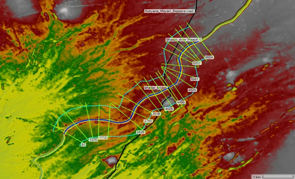
Electrical resistivity heatmap showing underground water detection zones and exact borewell drilling points identified through scientific survey.
Why Bhoojal Survey is India's Most Trusted Expert
Thousands of landowners, farmers, and industries across India trust Bhoojal Survey for one reason: we deliver accurate results, every time. Our geo hydrological survey team brings certified hydrogeologists, the most advanced instruments available in India, and a track record of over 1,170 successful projects to every site we visit.
- Triple-Instrument Accuracy: SSRMPATS + GER Detect + PQWT on every project — the most complete underground water profile available in India today.
- Certified Hydrogeologists: Qualified geologists with expertise across all Indian geological formations — basalt, granite, alluvial, sandstone, and mixed terrain.
- 95%+ Borewell Success Rate: Achieved consistently across 1,170+ projects spanning residential, agricultural, industrial, and government sectors.
- Trusted by Industry Leaders: IOCL, HPCL, NTPC, Reliance, John Deere, Infosys, Adani Ports, Cipla, and Lupin rely on Bhoojal Survey for their water detection and CGWA compliance needs.
- Rated 4.9 by 4500+ Customers: Consistent satisfaction across all project types and all 18+ cities and regions served.
- Full Written Report with GPS: Every project delivers a signed, data-backed report — GPS drilling point, depth estimate, yield projection, and CGWA compliance notes. Zero verbal-only recommendations.
- Pan-India Coverage: Indore, Bhopal, Jaipur, Ahmedabad, Bangalore, Jabalpur, Raipur, Dhar, Khargone, and 10+ more locations served.
- Free Initial Consultation: Speak to our hydrogeologist before booking. We give honest, free advice on what your project needs and what to expect from the survey results.
Multi-Method Survey Integration for Best Results
For maximum accuracy, every geo hydrological survey integrates multiple complementary scientific techniques. No single instrument gives the full picture — combining them does.
- Geophysical Surveys: Core fieldwork with SSRMPATS, GER Detect, and PQWT. See our Geodetic Survey Services for detailed subsurface precision mapping.
- Hydrogeological Surveys: Broader water cycle study — existing well data, seasonal groundwater levels, and quality testing through our Hydrogeological Survey services.
- Remote Sensing and GIS: Satellite imagery to identify fault lines, natural drainage patterns, and recharge zones before ground deployment — via our Remote Sensing Surveys.
- Groundwater Modeling: Computer simulations for large projects predicting long-term aquifer behavior and recharge rates — through our Groundwater Modeling services.
Frequently Asked Questions: Geo Hydrological Survey
Q What is a geo hydrological survey?
A geo hydrological survey is a scientific process combining geology and hydrology to study underground water resources. It uses SSRMPATS, GER Detect, and PQWT instruments to map aquifer zones, estimate water depth, and identify the exact borewell or open well drilling location — entirely from the ground surface, with no digging required.
Q How is a geo hydrological survey done?
The process involves a site-specific field investigation. The SSRMPATS maps deep rock layers, GER Detect measures electrical resistivity to find water-bearing zones, and PQWT uses Nuclear Magnetic Resonance to directly detect water molecules. All data is processed using specialised software to generate 2D and 3D underground maps. A written report with GPS-marked borewell point is delivered within one to two working days.
Q What is the difference between geo hydrological and hydrogeological survey?
A geo hydrological survey combines geological structure analysis and hydrological water movement study for a complete underground water profile. A hydrogeological survey focuses more specifically on groundwater movement through rock and soil. Bhoojal Survey's geo hydrological survey includes full hydrogeological mapping as a standard component — not a separate service.
Q Why is geo hydrological survey essential before drilling?
It eliminates the risk of a dry borewell entirely. Without a survey, over 30% of borewells in India fail or produce insufficient water — losing Rs. 80,000 to Rs. 3,00,000 with nothing to show. A geo hydrological survey provides precise aquifer location, depth data, and yield estimate before any drilling begins. In CGWA-notified zones, it is also legally mandatory for drilling permission.
Q How does PQWT instrument work in geo hydrological survey?
PQWT uses Nuclear Magnetic Resonance — identical in principle to hospital MRI — to directly detect water molecules underground. It sends electromagnetic pulses into the ground and measures the response from hydrogen nuclei in water molecules. This provides direct water confirmation and quantity estimation — not just inference from rock properties — making it the most precise water detection method available in geo hydrological survey practice.
Q What are the three main survey types in geo hydrological work?
Geophysical Survey — mapping subsurface rock and soil using electrical resistivity and seismic methods. Hydrogeological Survey — locating underground water sources, aquifer depths, and groundwater flow patterns. Hydrographic Survey — mapping physical features of surface water bodies including rivers, lakes, and reservoirs. A complete geo hydrological survey integrates all three for the most accurate results.
Q Can geo hydrological survey detect deep water aquifers?
Yes. The SSRMPATS and GER Detect instruments can detect water-bearing zones from 30 metres in alluvial plains to over 200 metres depth in hard rock terrain like granite and basalt. PQWT further confirms water presence and estimates yield at each depth. This three-instrument combination ensures the borewell reaches a sustainable, year-round aquifer — not a shallow seasonal zone that dries up in summer.
Q How long does a geo hydrological survey take?
For a standard residential or farm site, the field survey takes one to two days. The full written report is delivered within one to two working days after field work. Larger industrial or government projects may take three to seven days depending on site area and geological complexity. Emergency surveys can often be arranged within 24 to 48 hours — call +91-9691858058 to check availability for your location.
Q What are the risks of skipping a geo hydrological survey?
Skipping the survey results in guesswork drilling — over 30% chance of a completely dry borewell costing Rs. 80,000 to Rs. 3,00,000 with no water. In CGWA-notified zones, drilling without a proper geo hydrological survey report is also illegal and can result in the borewell being sealed after completion — a total loss of investment. Scientific analysis provides a 95%+ success rate; guesswork provides no guarantee at all.
Q Who needs professional geo hydrological survey services?
Farmers: To locate high-yield borewell points for reliable year-round irrigation. Industries and Builders: For CGWA NOC compliance and factory or housing water supply. Residential Landowners: For a private, reliable water source that does not fail in summer. Government Bodies: For Jal Jeevan Mission and rural drinking water project planning. Anyone drilling a borewell: A geo hydrological survey is the single most important step before drilling begins.
Conclusion: Secure Your Borewell with Data-Driven Water Detection
Water is your most valuable natural resource — and a failed borewell is one of the most avoidable losses in any land or infrastructure project. A professional geo hydrological survey backed by SSRMPATS, GER Detect, and PQWT gives you complete confidence before you drill a single metre.
From sub-surface seismic scanning and electrical resistivity mapping to NMR direct water detection and digital underground modelling — our team covers every dimension of scientific water detection. We deliver results you can trust — not guesses that cost you lakhs.
Do not let your drilling investment go dry. Book a scientific geo hydrological survey today — and guarantee your water source before the first drill touches the ground.
Scheme No. 114, Part-2, Indore, Madhya Pradesh – 452010, India
Phone: +91-9691858058
Email: [email protected]
Website: www.bhoojalsurvey.in
Hours: Monday – Saturday, 9:00 AM to 6:00 PM IST
Don't Drill Blind — Book Your Geo Hydrological Survey Today
Bhoojal Survey's expert team brings world-class geo hydrological survey technology to your land. One survey. One accurate borewell point. Zero guesswork.
Call +91-9691858058 Now Book Survey Online View All Survey Services