Flood Modeller: Role in Infrastructure & Solar Risk
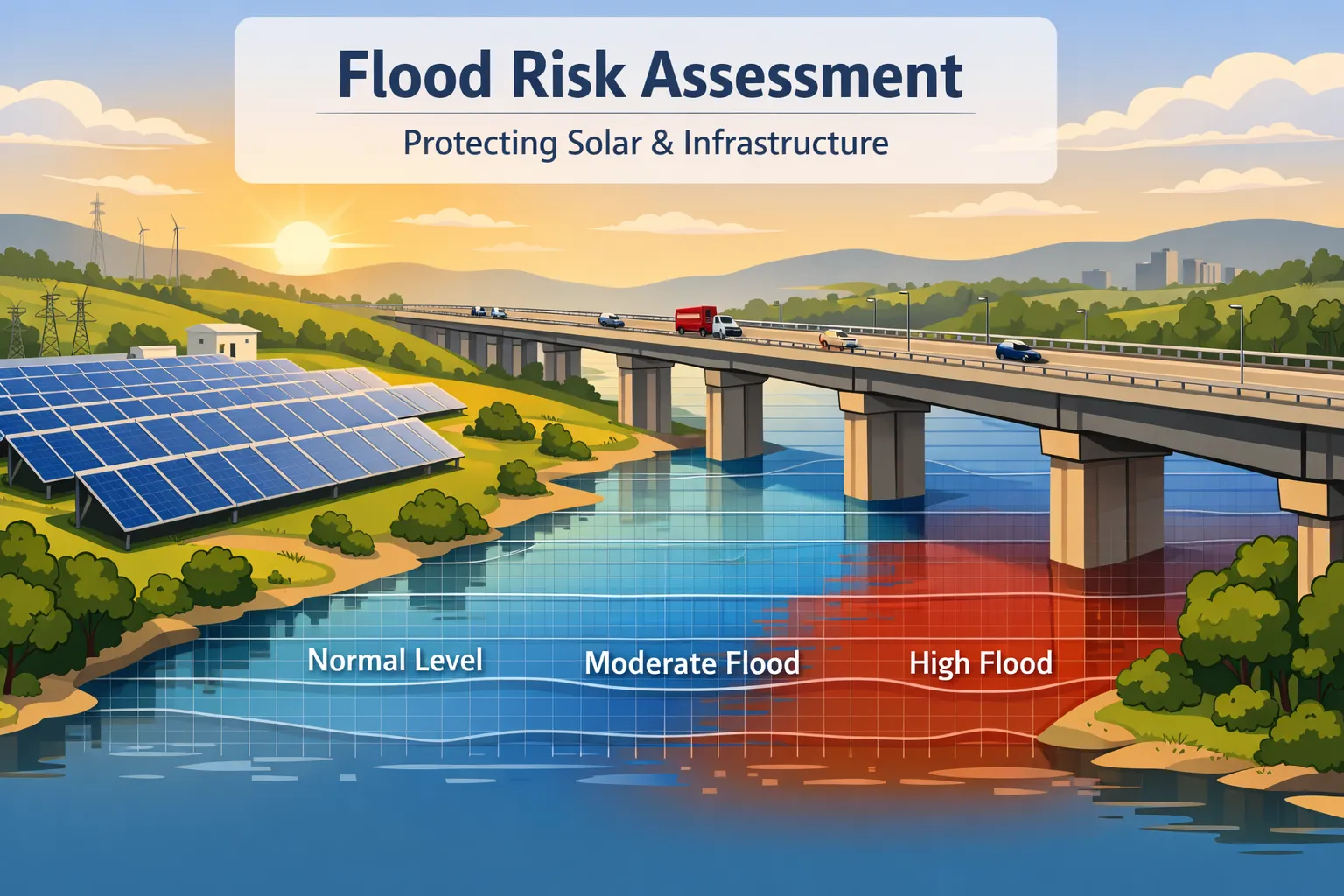
Why Flood Modelling Matters for Infrastructure & Solar Projects
India's infrastructure and renewable energy sectors are expanding rapidly into land that was previously undeveloped. Solar parks, highways, industrial zones, and smart city projects are being constructed on sites that may lie within flood-prone corridors — and without proper evaluation, the consequences can be severe. Flooding is no longer just a monsoon inconvenience; it is a structural and financial risk that must be quantified before a single foundation is laid.
flood modeling services is the scientific process of simulating how water moves across a landscape during rainfall events, identifying where it accumulates, how deep it gets, and how long it persists. It uses terrain data, rainfall intensity records, catchment geometry, and drainage network analysis to produce accurate flood extent and depth predictions.
A flood modeller is the specialist who designs and executes this process. They analyse terrain slope, simulate rainfall runoff, map flood-prone zones, and translate complex hydrological data into actionable engineering guidance. Their work forms the scientific foundation on which safe infrastructure is planned and built.
Professional agencies providing flood modeling services assist developers in understanding rainfall runoff patterns, terrain slope behaviour, and flood-prone zones prior to project development — giving engineers the data they need to design drainage systems, set foundation levels, and position critical equipment safely above predicted flood levels.
What is a Flood Modeller?
A flood modeller is a technical specialist who uses hydrological and hydraulic modelling tools to simulate flood behaviour across a defined area. Their role sits at the intersection of civil engineering, hydrology, GIS analysis, and data science. They are engaged during the pre-construction phase of projects to identify risks that are invisible to the naked eye but can cause millions of rupees in damage if ignored.
The core responsibilities of a flood modeller include:
- • Hydrological analysis — Studying rainfall patterns, catchment areas, infiltration rates, and runoff coefficients to understand how much water flows across a site during different storm return periods such as 10-year, 25-year, and 100-year events.
- • Terrain modelling — Building accurate digital elevation models from drone surveys or satellite data to map the precise shape of the land and identify low-lying zones where water will naturally accumulate.
- • Runoff simulation — Simulating how rainwater moves across the terrain surface, through drainage channels, and into receiving water bodies using software models calibrated to local conditions.
- • Flood prediction — Estimating flood water levels, inundation extents, and duration of flooding for various storm scenarios to define the flood risk envelope for the project site.
- • Drainage and mitigation design support — Providing hydrological data that engineers use to design appropriately sized drainage channels, retention ponds, culverts, and embankments to manage flood risk effectively.
Why Flood Modelling is Important for Infrastructure Projects
Infrastructure projects of every type are vulnerable to flooding if their hydrological environment is not properly understood before construction begins. A flood modeller provides the site-specific analysis that transforms general flood risk awareness into precise, actionable data. The scale and type of risk varies by project, but the need for scientific flood assessment is universal.
Here is why flood modelling is critical across different project types:
- • Solar power plants — Large solar parks cover hundreds of acres with panel foundations, cable trenches, inverter rooms, and transformer yards. Waterlogging can damage electrical systems, corrode foundations, and shut down operations during peak monsoon months. Flood modelling identifies which zones require raised foundations and where drainage infrastructure is critical.
- • Highways and road projects — Embankments crossing drainage paths, underpasses in low-lying areas, and bridges over seasonal streams all require accurate flood level data. Without it, roads flood repeatedly and require expensive remediation after every monsoon season.
- • Industrial zones — Factories and warehouses house expensive machinery and raw material stocks that cannot tolerate even shallow inundation. Flood modelling ensures that plinth levels, drainage layouts, and boundary protection are designed for the worst expected storm event.
- • Land development projects — Large-scale residential and commercial developments need flood zoning data to plan plot layouts, set minimum floor levels, and ensure that drainage networks are sized to handle peak runoff from the developed area.
- • Smart city projects — Urban infrastructure in new smart cities requires integrated flood management planning from the earliest design stage. A flood modeller provides the urban hydrology baseline that informs stormwater master plans and integrated water management systems.
Flood Risk Assessment and Infrastructure Safety
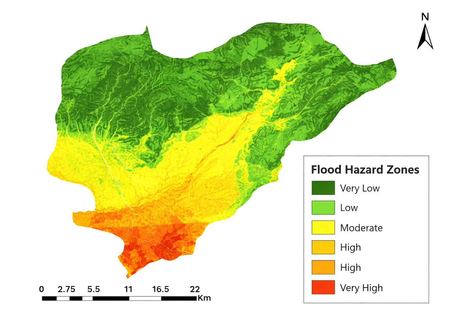
A comprehensive flood risk assessment goes beyond simply identifying whether a site floods — it quantifies flood depth, frequency, and duration, and evaluates the consequences for specific infrastructure elements. It covers flood level prediction for multiple storm return periods, identification of high-risk zones within the project boundary, drainage network capacity analysis, and site-specific mitigation recommendations. This structured approach allows engineers to make design decisions that are proportionate to the actual level of flood risk present at the site.
For developers and project managers seeking comprehensive pre-construction evaluation, detailed flood risk assessment studies provide the full technical foundation needed for safe design, regulatory compliance, and investor confidence. These studies integrate hydrological modelling, terrain analysis, drainage evaluation, and engineering recommendations into a single, report-ready deliverable.
Regional Flood Risk Assessment Across India
Madhya Pradesh
Madhya Pradesh hosts a large number of solar and infrastructure projects across its diverse terrain, from the Vindhyan plateau to the Narmada and Chambal river basins. Seasonal flooding in low-lying agricultural zones and flash flood events in hilly catchments pose a significant risk to construction timelines and long-term infrastructure integrity. A thorough flood risk assessment in Madhya Pradesh supports regional flood studies, drainage master planning, and infrastructure siting decisions — ensuring that solar parks and road projects in the state are designed with accurate knowledge of local flood hydrology.
Gujarat
Gujarat's extensive coastline, flat inland terrain, and dense industrial corridor create a combination of coastal inundation and stormwater flooding risks that demand detailed hydrological evaluation. Industrial estates, port-linked infrastructure, and solar installations along the Rann of Kutch and Gulf of Khambhat coastlines are particularly exposed to high-intensity rainfall and tidal flooding events. A structured flood risk assessment in Gujarat addresses coastal and industrial flood risks, helping developers protect capital investments and comply with coastal regulation zone requirements.
Maharashtra
Maharashtra receives some of the highest annual rainfall in India along the Western Ghats escarpment, while its urban centres — including Pune and the Mumbai Metropolitan Region — face severe urban flooding due to rapid impervious surface growth and overloaded drainage networks. Infrastructure and solar projects in the state must account for extreme rainfall intensities, flashy catchment responses, and urban waterlogging conditions. A detailed flood risk assessment in Maharashtra provides the hydrological analysis needed to design infrastructure that can withstand these heavy rainfall conditions without disruption.
Goa
Goa's small land area belies its complex flood hydrology — characterised by intense monsoon rainfall, laterite terrain with rapid runoff response, estuarine backwater flooding, and coastal inundation from storm surges. Infrastructure projects in low-lying coastal areas and river floodplains face compound flood risk from both upstream rainfall and downstream tidal influences simultaneously. A site-specific flood risk assessment in Goa evaluates coastal flood dynamics, estuarine backwater influence, and catchment runoff to provide a complete flood risk picture for project planning.
Tamil Nadu
Tamil Nadu faces a unique flood hydrology driven by the northeast monsoon, which delivers intense rainfall from October to December — a pattern quite different from the rest of peninsular India. Cyclone-induced extreme rainfall events further amplify flood risk along the coast and in river delta regions. Solar parks, coastal highways, and port-linked infrastructure in the state need flood assessments calibrated to cyclone return period rainfall scenarios. A technically robust flood risk assessment in Tamil Nadu addresses cyclone rainfall modelling needs and provides flood level predictions for planning safe infrastructure in this high-risk coastal state.
Karnataka
Karnataka spans the Western Ghats, the Deccan Plateau, and the coastal belt — three distinctly different hydrological zones with different rainfall intensities, drainage characteristics, and flood risk profiles. Infrastructure projects in the state encounter varied flood conditions ranging from flash flooding in Ghats terrain to seasonal inundation in plateau river basins. A comprehensive flood risk assessment in Karnataka conducts detailed rainfall and drainage studies tailored to the specific hydrological zone of the project site, ensuring that flood risk is accurately characterised for engineering design purposes.
Advanced Flood Modelling for Infrastructure Projects
Modern flood modelling for infrastructure uses an integrated suite of scientific tools and datasets that go far beyond simple flood plain mapping. The combination of high-resolution terrain data, GIS-based hydrology, and advanced simulation software allows a flood modeller to produce results that are specific, defensible, and directly usable for engineering design decisions.
The key technologies and methods used in advanced flood modelling include:
- • Digital Elevation Models (DEM) — High-resolution terrain models derived from drone surveys or satellite data form the geometric foundation of all flood simulation. Accurate DEMs allow the model to precisely predict where water flows, where it ponds, and at what depth — across the entire project area at engineering-grade resolution.
- • GIS hydrological modelling — Geographic Information System tools are used to delineate catchment boundaries, calculate catchment area and slope statistics, map drainage networks, and integrate land use data into runoff calculations, producing spatially accurate flood risk outputs.
- • Rainfall intensity analysis — Analysis of historical rainfall records and Intensity-Duration-Frequency (IDF) curves establishes the rainfall inputs for different storm return periods. This ensures that flood predictions are calibrated to the actual statistical probability of extreme events at the project location.
- • Catchment area study — Defining the full contributing catchment area — including land upstream of the project boundary — is essential for calculating peak runoff volumes accurately. Off-site catchment contributions are a major cause of unexpected flooding when ignored in design.
- • Drone terrain mapping — Drone-based topographic surveys provide centimetre-level accuracy terrain data for sites where existing maps are outdated or insufficiently detailed. This ensures that the DEM used in flood modelling truly represents the current land surface at the project site.
Flood Modelling and India's Infrastructure Resilience
The role of scientific flood assessment in building climate-resilient infrastructure across India is discussed in detail in the essential guide to flood modeling published by Bhoojal Surveys. This article provides detailed insights into flood modelling methodologies, the connection between terrain analysis and infrastructure resilience, and why pre-construction flood studies are becoming a non-negotiable part of responsible project development in India's rapidly changing climate environment.
Common Problems When Flood Modelling is Ignored
When a flood modeller is not engaged before construction begins, the consequences are often costly, sometimes irreversible, and always avoidable. The following problems occur repeatedly on projects where flood risk analysis was skipped or inadequately conducted:
- • Infrastructure flooding — Roads, bridges, embankments, and buildings designed without flood level data are repeatedly inundated during monsoon seasons, leading to structural damage, repair costs, and loss of service continuity.
- • Solar plant waterlogging — Panel foundations in low-lying zones become submerged during heavy rainfall, damaging electrical systems, corroding metal structures, and reducing energy generation output for extended periods after each monsoon event.
- • Drainage failure — Drainage channels and culverts designed without hydrological calculations are consistently undersized for actual peak flows, causing backwater flooding and stormwater overflow across the project site.
- • Soil erosion — Unmanaged surface runoff causes progressive erosion of access roads, embankment slopes, and unprotected soil surfaces, threatening both structural stability and long-term site productivity.
- • Project delays — Flooding during construction disrupts site operations, damages completed works, and forces redesign of drainage and foundation systems — adding months to construction schedules and significant costs to project budgets.
Conclusion: The Flood Modeller's Role in Safe Infrastructure Development
The role of a flood modeller in infrastructure and solar project development is not supplementary — it is foundational. Every decision about foundation levels, drainage system sizing, equipment placement, and site layout depends on accurate knowledge of how flood water will behave at the project location during extreme rainfall events. Without this knowledge, engineering design is built on assumption rather than evidence.
Infrastructure safety is not achieved through conservative engineering alone. It requires site-specific flood risk analysis conducted by a qualified flood modeller using current terrain data, regional rainfall records, and calibrated simulation models. This is the only scientifically defensible basis for designing structures that will reliably perform across a 25 to 50-year project lifetime in India's high-variability climate.
Scientific flood modelling must be treated as a non-negotiable first step in the planning of any major infrastructure or solar energy project. Engaging an experienced flood modeller before construction begins is not an additional cost — it is the most effective investment a developer can make in protecting the long-term integrity and financial performance of their project.
Frequently Asked Questions
What does a flood modeller do on a solar project?
A flood modeller on a solar project analyses the terrain, rainfall patterns, and catchment hydrology of the site to predict flood levels and inundation extents for different storm return periods. The outputs are used to set panel foundation heights, design drainage channels and retention systems, and identify zones where additional flood protection measures are required. This work protects both the capital investment in panels and equipment and the long-term generation performance of the plant.
What is the difference between flood modelling and flood risk assessment?
Flood modelling is the technical process of simulating flood behaviour using hydrological and hydraulic models. Flood risk assessment is the broader evaluation that uses flood modelling outputs along with consequence analysis, infrastructure vulnerability assessment, and mitigation recommendations to produce a complete risk picture. A flood risk assessment incorporates flood modelling as its core technical component, but also covers exposure, consequence, and management recommendations.
How is drone terrain mapping used in flood modelling?
Drone terrain mapping produces high-resolution Digital Elevation Models (DEMs) that serve as the geometric foundation for all flood simulation. Standard topographic maps are often too coarse or outdated to accurately represent current ground conditions across large project sites. Drone surveys capture the terrain at centimetre-level accuracy, ensuring that the flood model correctly simulates water flow paths, accumulation zones, and drainage network behaviour — producing results that reflect actual site conditions rather than generalised terrain approximations.
Is flood modelling required for infrastructure approvals in India?
For projects requiring Environmental Impact Assessment (EIA) clearance, Coastal Regulation Zone (CRZ) approvals, or state-level infrastructure permits in flood-prone districts, flood risk assessment documentation is increasingly required as part of the regulatory submission. Beyond regulatory obligations, flood modelling for infrastructure is a technical necessity for any project where flooding could threaten structural safety, operational continuity, or financial viability over the project lifetime.