


Understanding Flood Risk Assessment in Madhya Pradesh
When monsoon arrives in Madhya Pradesh, it brings life to farms but also brings the fear of floods. Every year, many areas across the state face flooding that damages homes, roads, crops, and sometimes takes lives. This is where Flood Risk Assessment becomes important—it's a way to understand which areas are at risk and how we can protect people and property before the water comes.
In simple words, Flood Risk Assessment means studying rivers, rainfall patterns, land shapes, and past flood history to predict where flooding might happen. It helps the government, builders, and farmers make smart decisions about where to build, how to plan drainage, and how to stay safe during heavy rains.
Why Madhya Pradesh Needs Flood Risk Assessment
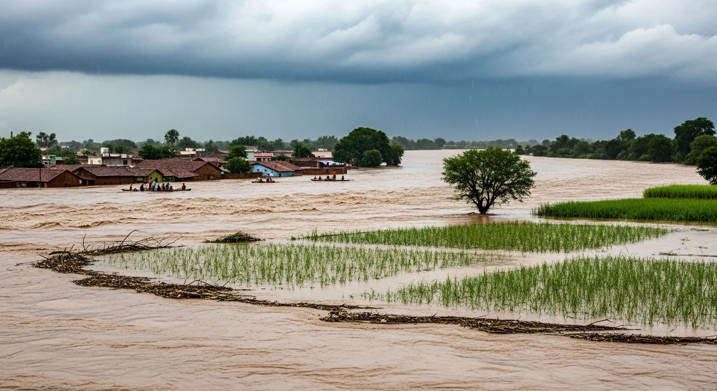
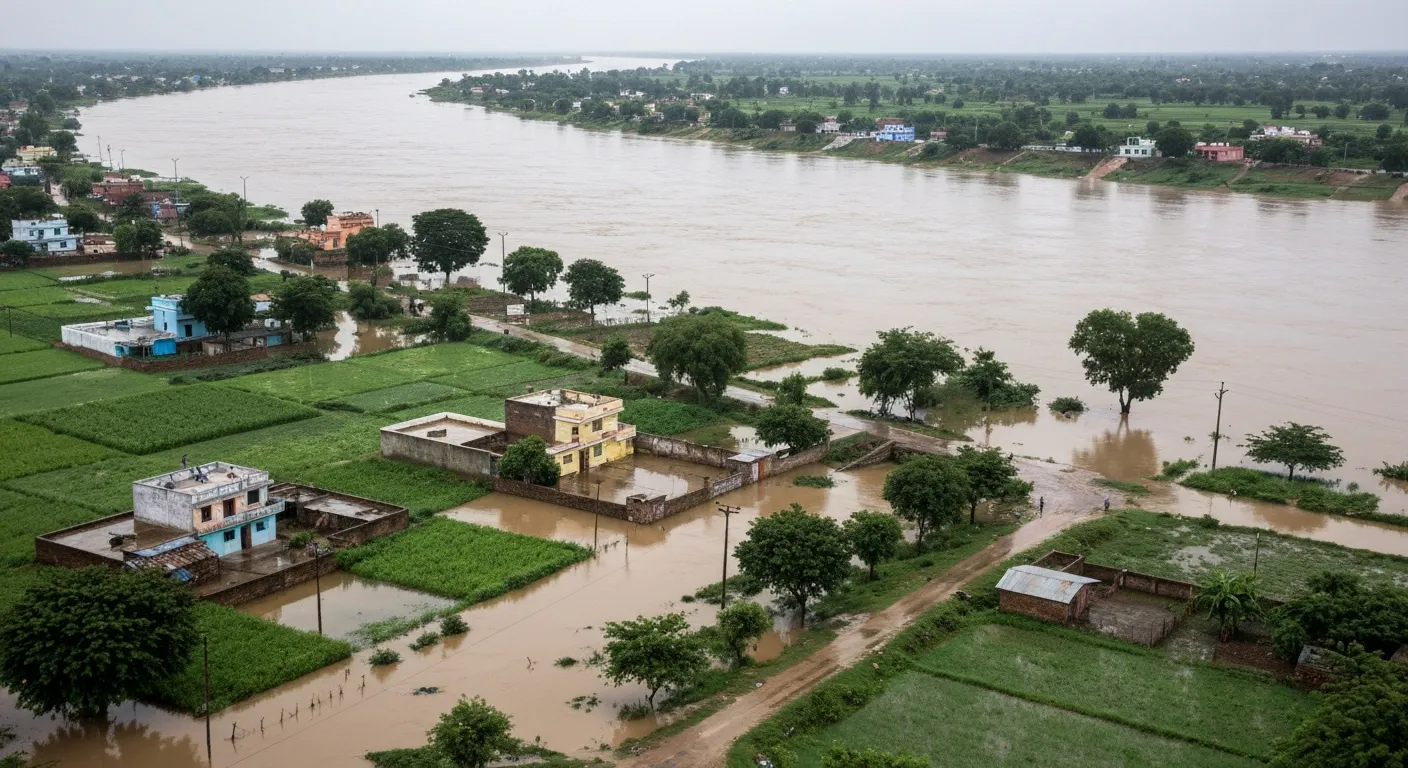
Madhya Pradesh sits right in the heart of India, and several big rivers flow through it—Narmada, Chambal, Betwa, and others. When monsoon rains are heavy or when dams release water suddenly, these rivers overflow their banks and flood nearby villages and towns.
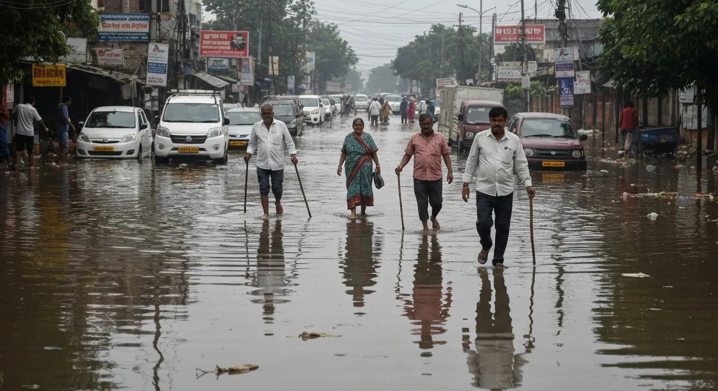
Cities like Bhopal, Indore, and Jabalpur have grown rapidly in recent years. More buildings mean less open ground for water to soak in. When it rains heavily, water has nowhere to go—it floods streets, enters homes, and disrupts life. Roads get damaged, schools close, and businesses suffer losses.
Flood Risk Assessment helps us see these problems coming. It shows which neighborhoods, which roads, and which farmlands are most likely to flood. With this knowledge, people can prepare better, build stronger drainage systems, and avoid building homes in dangerous spots.
Main Flood-Prone Areas in Madhya Pradesh
Some parts of Madhya Pradesh face flooding almost every monsoon. Let's look at the main areas:
Narmada River Belt
The Narmada is one of India's most important rivers, and it flows right through the heart of MP. Districts like Narmadapuram (earlier called Hoshangabad), Dhar, Barwani, Khandwa, and Raisen see regular flooding during heavy rains. When water is released from dams like Indira Sagar and Omkareshwar, river levels rise quickly and flood the surrounding areas.
Villages along the riverbank often get submerged. Roads connecting towns get waterlogged, making travel impossible. Farmers lose their crops, and families sometimes have to evacuate their homes.
Chambal Region
The Chambal river flows through the northern part of Madhya Pradesh, especially around Morena and Bhind. This region also faces flooding during monsoon. The problem here is not just heavy rain—soil erosion and poor drainage make things worse. Water stays on fields for days, damaging crops and making life difficult for villagers.
Central and Eastern MP
Cities like Bhopal, Indore, and Vidisha have grown so fast that old drainage systems can't handle the water anymore. When it rains heavily, roads turn into rivers. Areas in Jabalpur, Rewa, Satna, Seoni, and Mandla also face flooding because of rivers like Narmada, Son, and their smaller tributaries.
Urban flooding is different from river flooding. It happens because cities have too much concrete and not enough space for rainwater to drain naturally. This kind of flooding can be prevented with proper planning and better drainage design—which is exactly what Flood Risk Assessment helps with.
How Flood Risk Assessment is Done
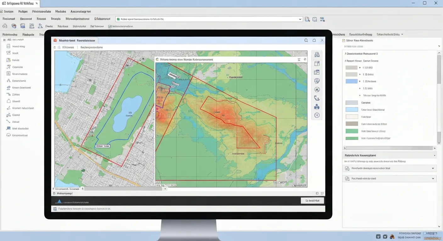
Flood Risk Assessment is not guesswork. It's a careful process done by experts using modern technology. Here's how it works in simple steps:
Step 1: Collect Information
First, experts collect data about the area—how much rain falls each year, which rivers are nearby, what the land looks like (flat or sloped), and where floods happened in the past. They also check satellite images to see how water flows across the land.
Step 2: Study the Land and Rivers
Using special computer software (like GIS tools), experts create digital maps showing the height of land, river paths, and low-lying areas. Low areas are where water collects first—these are the most risky zones.
Step 3: Run Simulations
Experts use models to see what would happen if heavy rain falls or if dams release water. They test different scenarios—light rain, heavy rain, extreme rain. The model shows how deep the water will get, how fast it will flow, and which areas will flood first.
Step 4: Create Flood Maps
Based on all this analysis, flood maps are created. These maps show three zones—low risk (safe areas), medium risk (some flooding possible), and high risk (very likely to flood). These maps guide everyone from government officials to farmers and builders.
How Flood Risk Assessment Helps Madhya Pradesh
So why do we need all this? Because Flood Risk Assessment saves lives, money, and time. Here's how:
- Better Planning: When building new roads, bridges, or townships, engineers can avoid flood-prone zones or design stronger drainage systems.
- Farmer Protection: Farmers can know which fields are at risk and plan their crops accordingly. They can also get help from the government to build protective barriers.
- City Safety: Cities like Bhopal and Indore can improve their drainage networks based on flood maps, reducing street flooding during monsoon.
- Emergency Preparedness: When floods are predicted, authorities can evacuate people from high-risk zones before water arrives, saving lives.
- Smart Development: Industries, airports, and residential projects can be planned in safer locations, avoiding future losses.
A Real-Life Example from Madhya Pradesh
Let's understand with a simple story. A few years ago, a highway was planned in the Narmadapuram district. The initial design placed the road close to the Narmada riverbank because it was the shortest route.
Before construction started, a Flood Risk Assessment was done. The study showed that this section of the road would flood almost every monsoon when the river level rises. Building the road there would mean frequent closures, expensive repairs, and danger to travelers.
Based on the assessment, engineers changed the route. The road was shifted slightly inland to higher ground. They also designed bigger drainage culverts to handle monsoon water. When the road was finally built, it remained safe and operational even during heavy rains—exactly as predicted by the flood model.
This is the power of Flood Risk Assessment. It doesn't just predict problems—it provides solutions that work.

Looking Ahead: Flood Safety for Madhya Pradesh
Climate patterns are changing. Rainfall is becoming more unpredictable—some years too much, some years too little. Madhya Pradesh needs to prepare for more frequent and intense floods in the coming years.
Flood Risk Assessment is not a one-time task. It needs to be done regularly, especially as cities grow and new infrastructure is built. Every new project—whether it's a factory, a township, or a metro line—should include flood risk analysis from the beginning.
The government, engineers, and citizens must work together. Better drainage systems, protecting natural water bodies, avoiding construction in flood zones, and listening to flood warnings—all these steps will make Madhya Pradesh safer and more resilient.
With proper Flood Risk Assessment and smart planning, we can reduce flood damage significantly. We can protect homes, save crops, keep roads open, and most importantly, keep people safe. That's the future Madhya Pradesh deserves—a future where we live with rivers, not in fear of them.
Bhoojal Survey's Expertise in Madhya Pradesh
Bhoojal Survey plays a vital role in flood risk assessment across Madhya Pradesh by combining groundwater science, surface water analysis, and advanced GIS-based hydrological tools to deliver reliable and practical flood safety solutions. Working across diverse projects such as national highways, urban infrastructure, industrial developments, and agricultural planning throughout MP, Bhoojal Survey supports informed decision-making at both project and policy levels.
Through scientifically developed flood models and flood mapping in Madhya Pradesh, the organization helps reduce flood damage, improve water management, and promote sustainable development in flood-prone regions like the Narmada river belt, Chambal region, and growing cities like Bhopal, Indore, and Jabalpur. Its multidisciplinary expertise and involvement in large-scale development projects reflect strong institutional capability, contributing not only to flood risk mitigation but also to long-term groundwater conservation and water security initiatives across Madhya Pradesh.