


Understanding Flood Risk Assessment in Maharashtra
Maharashtra faces serious flooding every monsoon season—from the crowded streets of Mumbai to the rivers of Western Maharashtra and the Godavari basin. Flood risk assessment helps us understand which areas are most vulnerable to flooding and how we can protect lives, homes, businesses, and farms before the water arrives.
In simple terms, it means studying rainfall patterns, river behavior, land slopes, drainage systems, and past flood records to predict where flooding might happen. This knowledge helps the government, builders, farmers, and city planners make smart decisions about construction, drainage design, and emergency planning.
Why Maharashtra Needs Flood Risk Assessment
Maharashtra is one of India's most developed states, but it's also one of the most flood-affected. The state has a long coastal line, major rivers, and rapidly growing cities. This combination creates unique flooding challenges that need careful planning and assessment.
Every year, monsoon brings heavy rainfall that overwhelms drainage systems, causes rivers to overflow, and triggers urban flooding in Mumbai. Cloudburst events in Western Maharashtra and dam water releases in the Krishna and Godavari basins add to the problem. Without proper Flood Risk Assessment, these recurring floods will continue to cause massive damage.
Key Problems Maharashtra Faces:
- Heavy monsoon rainfall concentrated in just a few months
- Rapid urbanization reducing natural drainage areas
- Rivers overflowing when dams release water suddenly
- Coastal areas facing flooding from high tides combined with rain
- Old drainage systems unable to handle today's water volumes
- Construction in flood-prone zones without proper planning
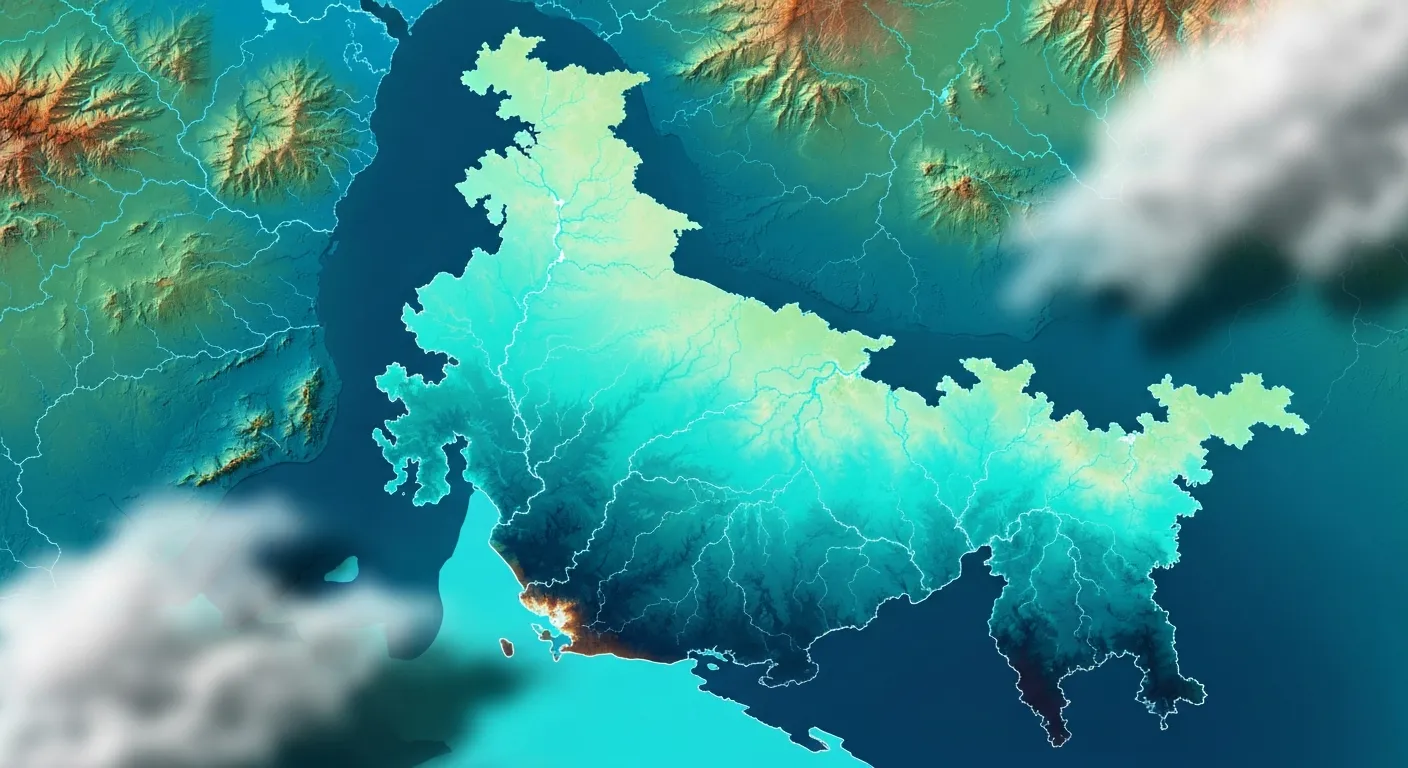
Major Flood-Prone Areas in Maharashtra
Different parts of Maharashtra face different types of flooding. Understanding these regional patterns is essential for effective Flood Risk Assessment.
Konkan Coast Region
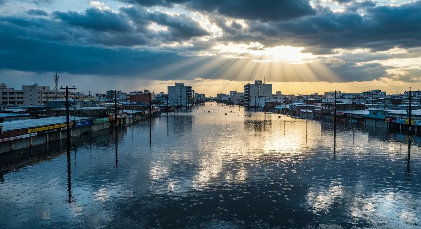
The Konkan coast includes Mumbai, Thane, Raigad, Ratnagiri, and Sindhudurg districts. This region faces the most intense monsoon rains in Maharashtra. Mumbai experiences severe urban flooding almost every monsoon when drains overflow and low-lying areas get waterlogged for hours or even days.
The problem here is not just heavy rainfall—it's the combination of rain, high tides, blocked drainage, and too much concrete. When high tide coincides with heavy rain, water cannot drain into the sea, causing widespread street flooding. Areas like Dadar, Parel, Sion, and Hindmata face this problem regularly.
Western Maharashtra
Districts like Kolhapur, Sangli, Satara, and parts of Pune face regular flooding from the Krishna and its tributaries. When heavy rain falls in the catchment areas or when upstream dams release water, these districts experience severe flooding.
The 2019 floods in Kolhapur and Sangli showed how devastating these floods can be. Entire villages were submerged, thousands of people had to evacuate, crops were destroyed, and roads were cut off for weeks. This is exactly the kind of disaster that Flood Risk Assessment helps prevent or minimize.
Godavari Basin
The Godavari river and its tributaries flow through Nashik, Aurangabad, Nanded, and Jalna districts. When monsoon arrives, these rivers can rise quickly and flood the surrounding farmland and villages. Dam releases from upstream states also contribute to flooding in Maharashtra's Godavari basin.
Farmers in these areas often lose entire crops to flooding. Towns near riverbanks face water entering homes and shops. Roads connecting villages get damaged, making rescue and relief operations difficult.
Vidarbha Region
Nagpur, Chandrapur, and other Vidarbha districts face flooding from rivers like Wainganga and Wardha. Though not as frequent as coastal flooding, when heavy rainfall occurs in this region, the impact on agriculture and rural infrastructure can be severe.

How Flood Risk Assessment Works
Flood Risk Assessment is a scientific process done by experts using modern technology. Here's how it works in simple steps:
Step 1: Collect Data
Experts gather information about rainfall patterns, river levels, land elevation, soil types, drainage networks, and historical flood data. Satellite images and survey data help create accurate digital maps of the area.
Step 2: Analyze Terrain and Rivers
Using GIS software, experts create 3D models showing how water flows across the land. They identify low-lying areas where water naturally collects, steep slopes where water runs fast, and bottlenecks in drainage systems.
Step 3: Run Flood Simulations
Computer models simulate different scenarios—normal monsoon, heavy rainfall, extreme cloudbursts, dam releases. These simulations show how deep water will get, how fast it will flow, which areas will flood first, and how long water will stay.
Step 4: Create Risk Maps
Based on the analysis, detailed flood risk maps are created. These maps color-code areas into low risk (safe), medium risk (occasional flooding possible), and high risk (frequent flooding likely). These maps guide all planning and construction decisions.

Benefits of Flood Risk Assessment in Maharashtra
Proper Flood Risk Assessment brings multiple benefits to Maharashtra's people, cities, and economy:
For Cities and Urban Areas:
- Better drainage system design that handles peak monsoon flow
- Identification of flooding hotspots for priority improvement
- Smart urban planning that avoids construction in flood zones
- Reduced traffic disruption and business losses during monsoon
- Protection of metro stations, underpasses, and infrastructure
For Transportation:
- Highways and bridges designed to stay above flood levels
- Railway tracks protected from submersion during heavy rain
- Proper culvert sizing to prevent road flooding and washouts
- Alternative routes planned for emergency situations
For Farmers and Rural Areas:
- Early warning systems help farmers protect crops and livestock
- Better irrigation planning that accounts for flood risks
- Government assistance targeted to high-risk agricultural zones
- Reduced crop losses through preventive measures
For Industries and Businesses:
- Site selection that avoids flood-prone locations
- Factory design with elevated critical equipment
- Business continuity planning based on realistic flood scenarios
- Lower insurance costs due to demonstrated risk management
A Real Example from Maharashtra
A few years ago, a residential township was planned near Pune on land close to a seasonal stream. The developer saw flat land at a good price and started planning 200+ homes, roads, and community facilities.
Before approvals were given, local authorities required a Flood Risk Assessment. The study revealed that during heavy monsoon rainfall, this stream swells significantly and floods the proposed site. The simulations showed water depths of 1-2 meters in the lowest areas—enough to submerge ground floors and make roads impassable.
Based on these findings, the developer made important changes. The layout was redesigned to keep buildings away from the highest-risk zones. Ground floors were elevated above predicted flood levels. A proper drainage channel was included to divert stream overflow safely around the township. Open spaces were positioned in flood-prone areas instead of buildings.
When the township was completed and the next heavy monsoon arrived, water did flow through the area as predicted. But because of the Flood Risk Assessment and smart design changes, not a single home was damaged. The drainage system worked perfectly, water flowed through planned channels, and residents stayed safe and dry.
This is the real value of Flood Risk Assessment—it turns potential disasters into manageable situations through smart planning.

Moving Forward with Flood Safety
Climate change is making weather more unpredictable. Maharashtra may face more intense rainfall events and longer dry periods. Both extremes create challenges—floods during monsoon and water scarcity during summer.
Flood Risk Assessment needs to become a standard part of all development planning in Maharashtra. Every new project—whether it's a highway, housing society, industrial park, or metro line—should include proper flood analysis from day one.
Cities like Mumbai need continuous updates to their flood maps as development changes drainage patterns. Western Maharashtra needs better coordination on dam water releases with early warnings to downstream areas. The Konkan coast needs upgraded drainage systems designed for today's rainfall intensities, not yesterday's standards.
With proper Flood Risk Assessment and coordinated action between government, engineers, and communities, Maharashtra can significantly reduce flood damage. We can protect more lives, save more crops, keep businesses running, and build a more resilient state for the future.
Bhoojal Survey's Work in Maharashtra
Bhoojal Survey plays a vital role in flood risk assessment across Maharashtra by combining groundwater science, surface water analysis, and advanced GIS-based hydrological tools to deliver reliable and practical flood safety solutions. Working across diverse projects from the Konkan coast to Western Maharashtra, Vidarbha, and the Godavari basin, Bhoojal Survey supports informed decision-making for urban development, industrial projects, agricultural planning, and infrastructure development.
Through scientifically developed flood models and detailed flood mapping in Maharashtra, the organization helps reduce monsoon flood impact, improve water management, and promote sustainable development practices. Our expertise in handling unique challenges like urban flooding in Mumbai, river basin flooding in Kolhapur-Sangli, and coastal flood dynamics reflects strong institutional capability. We contribute not only to immediate flood risk mitigation but also to long-term water resource sustainability and climate resilience initiatives across Maharashtra.