By Bhoojal Survey Team | Certified Hydrogeologists & GPR Survey Experts | Updated March 2026
Bhoojal Survey GPR Surveyor team conducting field survey in Madhya Pradesh for borewell location
Imagine spending ₹1,50,000 drilling a borewell — and getting no water. This is a reality for thousands of farmers, landowners, and builders across India every year. Borewell failure is not bad luck. It is the result of drilling without scientific data. That is where a professional GPR Surveyor changes everything.
In 2026, Groundwater Survey Services using Ground Penetrating Radar combined with hydrogeological instruments give you a complete underground map before a single machine touches your land. At Bhoojal Survey, our expert GPR Surveyor team has helped 1170+ clients — farmers, housing societies, industries, and government bodies — find water with over 95% success rate. Book your survey today and stop gambling with your investment.
Real Fact: Over 30% of borewells drilled without a scientific survey fail to produce usable water — wasting ₹50,000 to ₹2,00,000 per project. A professional GPR Surveyor survey costs a fraction of that and can prevent the entire loss.
Common Borewell Problems Faced by Farmers, Landowners & Builders
Every failed borewell tells the same story. The owner did not know where the water was, chose a drilling spot based on guesswork or unscientific advice, and lost their entire investment. A qualified GPR Surveyor can prevent every single one of these situations.
Here are the most common problems that drive people to search for an accurate groundwater detection service:
- No Water After Drilling: The most devastating outcome. Drilling through 100+ metres of rock and finding nothing. A professional GPR Surveyor eliminates this risk by mapping water-bearing zones before drilling begins.
- Massive Financial Loss: Borewell drilling costs ₹50,000–₹2,00,000 depending on depth and location. Without a survey, this entire amount is at risk. A GPR survey protects your investment with scientific certainty.
- Wrong Location Selection: Water may be available 20 metres away from where you drilled. A GPR Surveyor maps the exact location and depth of underground water so your contractor drills at the right spot — first time.
- Time Wastage: A failed borewell means starting again — re-hiring contractors, waiting for permits, and losing months of productive time. One correct survey saves all of this.
- Seasonal Water Failure: Borewells drilled without a hydrogeological survey often dry up in summer. A scientific survey identifies perennial aquifer zones that deliver water year-round.
Why Traditional Water Detection Methods Fail in 2026
Millions of Indians still rely on water diviners, divining rods, or "local knowledge" to find water before drilling a borewell. In 2026, these methods have no place in a scientific water detection workflow — and the failure rates prove it.
Before understanding how a GPR Surveyor solves the problem, it is important to know why traditional methods consistently fail:
- Pure Guesswork: Divining rods and pendulums have been scientifically tested multiple times — and have consistently shown results no better than random chance. There is no mechanism by which they can detect underground water.
- No Scientific Data: Traditional methods produce no written data, no maps, no depth estimates, and no yield predictions. There is nothing to verify, validate, or act on.
- No Geological Context: A local advisor may know that a neighbour has water at 60 metres — but underground geology changes dramatically across even short distances. What works next door may fail completely on your plot.
- Low Success Rate: Projects relying on traditional methods have borewell failure rates above 30–40%. A professional GPR Surveyor combined with hydrogeological analysis brings this rate down to under 5%.
- No Legal Validity: In CGWA-notified zones, a hydrogeological survey report from a certified expert is now legally required before drilling permission is granted. Divining rods cannot satisfy this requirement.
2026 Warning: Do not hire anyone who offers to "find water" without using instruments like GPR, GER Detect, or PQWT. Without instruments, data, and a written report — you are paying for guesswork, not a survey.
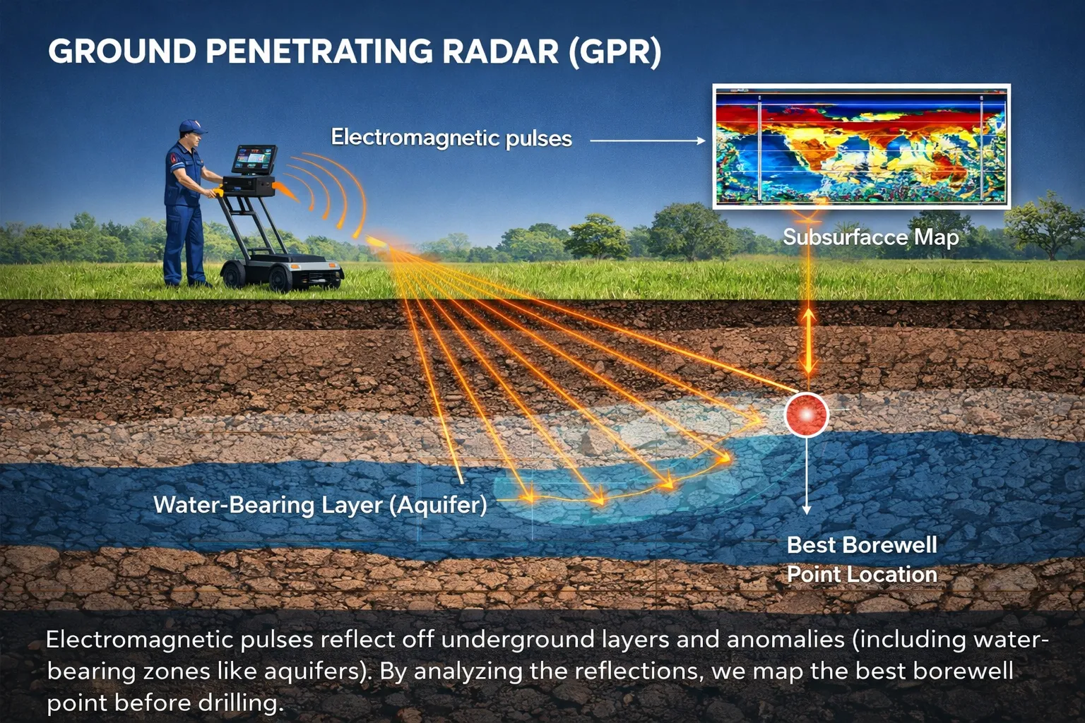
How a GPR Surveyor Solves the Borewell Problem
Ground Penetrating Radar (GPR) technology uses high-frequency electromagnetic pulses transmitted into the ground. These pulses reflect off boundaries between different materials — soil, rock, clay, voids, and water-saturated zones — and are received back by the instrument to create a detailed subsurface profile.
A professional GPR Surveyor interprets these profiles to identify water-bearing formations, estimate their depth, and recommend the optimal borewell drilling location. The result is a data-backed, GPS-mapped drilling recommendation that your contractor can act on with full confidence.
- Scientific Scanning: GPR scans the ground non-invasively from the surface — no digging, no drilling, no property damage.
- In-Depth Analysis: The GPR Surveyor combines radar data with electrical resistivity and NMR data for a complete underground picture.
- Accurate Results: Multi-instrument analysis delivers a final recommendation with GPS coordinates, depth estimate, and yield projection.
- Written Report: Every professional GPR survey produces a written, signed report — legally valid for CGWA NOC applications and contractor briefings.
- Faster Decisions: Field surveys are completed in one to two days. Reports are delivered within 48 hours. Your contractor can start drilling with data in hand.
How Bhoojal Survey's GPR Surveyor Team Finds Water Accurately
Bhoojal Survey is one of India's most trusted Hydrogeological Survey Experts, with a certified team of geologists and hydrogeologists who have completed thousands of successful surveys across India. Our multi-instrument approach combines GPR technology with GER Detect electrical resistivity and PQWT Nuclear Magnetic Resonance — delivering the highest achievable accuracy for groundwater detection.
We do not just point to a spot and say "drill here." Every GPR Surveyor engagement from Bhoojal Survey follows a structured, science-based process that eliminates guesswork and gives your drilling contractor exactly what they need.
●
SSRMPATS
Seismic Subsurface Resistivity Mapping & Profiling Advanced Technology System — maps subsurface layer boundaries and identifies fracture zones where water accumulates.
●
GER Detect
Electrical Resistivity Tomography — measures how strongly underground materials resist electrical current. Water-saturated zones show distinctly lower resistivity, pinpointing aquifer locations.
●
PQWT (NMR)
Proton Quantity Water Detector — uses Nuclear Magnetic Resonance to directly detect water molecules underground. Also estimates the quantity of water available, predicting borewell yield.
Our Step-by-Step GPR Surveyor Process
- Site Inspection & Consultation: Our hydrogeologist discusses your water requirement, reviews local geological maps, and assesses surface features before deploying any instruments.
- GPR Scanning: The GPR Surveyor deploys instruments across your plot. Multiple scan lines are run in different directions to build a complete subsurface profile.
- GER Detect Resistivity Survey: Electrodes are placed in the ground and the GER Detect instrument maps water-bearing zones by measuring electrical resistivity at progressive depths.
- PQWT NMR Survey: The PQWT instrument sends electromagnetic pulses to directly detect water molecules and estimate yield — particularly effective in hard rock formations.
- Data Analysis & Interpretation: All instrument data is processed using specialised software to create 2D and 3D underground maps. Our hydrogeologist interprets anomalies to identify the best aquifer zone.
- Bore Point Marking: The optimal drilling spot is physically marked on your property with GPS coordinates recorded for your drilling contractor.
- Survey Report Delivery: A complete written report is delivered within 48 hours — covering site maps, instrument data, depth estimates, yield projections, casing specifications, and CGWA compliance notes.
Book GPR Survey for Borewell Today
Don't risk your investment. Our expert GPR Surveyor team will visit your site, scan with SSRMPATS, GER Detect, and PQWT, and deliver a written report so you drill at the right spot — the first time.
Call +91-9691858058 Now
Contact Bhoojal Experts Now
Borewell Location Using GPR Surveyor — Practical Use Cases
A professional borewell survey service using GPR technology is not just for large industries. Farmers, individual landowners, and small builders across India are now using GPR Surveyor services to make smarter drilling decisions before they commit to drilling costs.
Here is how different types of clients benefit from Bhoojal Survey's Borewell Location Service:
- Farmers & Agricultural Land: Irrigation borewells on farm land must produce consistent yield through summer. A GPR Surveyor identifies perennial aquifer zones — not just seasonal shallow water — ensuring crop water supply year-round. Thousands of farms across Madhya Pradesh, Rajasthan, and Gujarat have benefited from Bhoojal Survey's agricultural borewell location service.
- Residential Plots & Housing Societies: Before investing in a private borewell for a house or apartment complex, a GPR Surveyor confirms whether the plot has viable groundwater. This prevents wasted drilling costs and ensures the borewell serves the building reliably for years.
- Commercial & Industrial Projects: Factories, manufacturing plants, and warehouses need large-volume water supply. The GPR Surveyor identifies high-yield aquifer zones that can sustain industrial water demand.
- Construction Sites: Before drilling for construction dewatering or permanent water supply, a GPR scan also identifies underground utilities, pipes, and cables — preventing costly accidental damage during drilling.
- Government & Municipal Water Projects: State water boards and gram panchayats use Bhoojal Survey's GPR Surveyor service to plan village drinking water borewells efficiently and cost-effectively.
Groundwater Detection by GPR Technology — How It Works Scientifically
Understanding the science behind a GPR Surveyor survey helps you appreciate why it delivers results that traditional methods simply cannot. Ground Penetrating Radar works by transmitting short electromagnetic pulses into the ground at frequencies typically between 10 MHz and 2.6 GHz depending on the required depth and resolution.
As these pulses travel through the earth, they reflect back to the surface antenna whenever they encounter a boundary between materials with different dielectric properties — such as the boundary between dry rock and water-saturated rock. The GPR Surveyor's instrument records the time it takes for each reflection to return, which directly corresponds to the depth of that boundary. This is the scientific method for water detection that forms the foundation of modern groundwater exploration.
What GPR Can Detect Underground
- Water-bearing fracture zones and saturated aquifer layers
- Geological layer boundaries — soil, weathered rock, hard rock transitions
- Underground utilities — metallic and non-metallic pipes, cables, and conduits
- Voids, cavities, and karst formations that affect drilling stability
- Rebar and concrete foundations in urban construction surveys
- Depth to bedrock — critical for planning borewell casing specifications
Why Multi-Instrument Approach Matters: GPR alone has limitations in high-clay and high-moisture soils. Bhoojal Survey combines GPR with GER Detect and PQWT to ensure accurate groundwater detection in all Indian geological formations — from alluvial plains to hard Deccan basalt.
GPR Surveyor vs Traditional Water Detection Methods — 2026 Comparison
The difference between hiring a best GPR surveyor in India and relying on traditional methods is not just about technology — it is about the certainty of your investment. Here is a direct comparison:
| Factor |
GPR Surveyor (Bhoojal Survey) |
Traditional Methods |
| Scientific Basis | Yes — electromagnetic principles | No — guesswork / folklore |
| Depth Detection | 60–250+ metres | No depth data available |
| Water Yield Estimate | Yes — via PQWT NMR | No estimate possible |
| Written Report | Yes — GPS-mapped, signed | No documentation |
| CGWA Legal Acceptance | Yes | No |
| Borewell Success Rate | 95%+ | 60–70% (30%+ failure) |
| Non-Metallic Utility Detection | Yes — PVC, clay pipes, cables | No |
| Survey Completed In | 1–2 days, report in 48 hrs | Varies, often unreliable |
Best Hydrogeological Survey Methods in 2026
In 2026, the most accurate accurate groundwater detection service combines multiple geophysical instruments rather than relying on a single method. Bhoojal Survey's approach integrates four complementary survey methods that each contribute a unique layer of data to the final groundwater map.
- GPR (Ground Penetrating Radar): Rapid shallow-to-medium depth scanning for geological layer mapping and utility detection. Best for alluvial terrain and pre-construction surveys.
- SSRMPATS: Seismic subsurface profiling that maps deep rock layer boundaries and identifies fracture zones — the primary pathways of groundwater in hard rock terrain.
- GER Detect (ERT): Electrical Resistivity Tomography providing deep penetration up to 250+ metres. Creates 2D and 3D resistivity maps that clearly show water-saturated zones.
- PQWT (NMR): The only instrument that directly detects water molecules — not just rock properties. Also estimates water quantity, making yield prediction possible before drilling.
- Remote Sensing & GIS: Satellite-based geological lineament mapping used as a preliminary screening tool to identify high-potential zones before field deployment.
Importance of Hydrogeological Survey Before Borewell Drilling
A hydrogeological survey is the scientific foundation of every successful borewell project. It goes beyond the GPR scan to study the complete groundwater system — geology, rainfall, seasonal water levels, and aquifer characteristics — giving you a complete picture of what you are drilling into.
At Bhoojal Survey, our Hydrogeological Survey Experts prepare CGWA-accepted reports that satisfy all regulatory requirements while giving your drilling team the most complete subsurface data available. Here is why this survey is non-negotiable before any borewell project:
- Risk Reduction: A proper survey eliminates the primary risk in borewell drilling — drilling in the wrong location. Scientific data replaces guesswork entirely.
- Cost Saving: The survey costs a small fraction of drilling costs but protects the entire drilling investment — often 10x to 30x the survey fee.
- Accurate Depth Planning: Knowing how deep to drill prevents unnecessary drilling costs and ensures you reach the productive aquifer zone without overshooting.
- Water Quality Assessment: The survey identifies whether groundwater is safe for its intended use — preventing investment in a borewell that delivers poor-quality water.
- CGWA Legal Compliance: In over-exploited and critical groundwater zones, a certified hydrogeological report is legally mandatory for obtaining drilling permission from CGWA.
- Long-Term Sustainability: The survey report tells you how long the aquifer is likely to sustain your extraction rate — helping you plan recharge measures and avoid future water scarcity.
CGWA NOC for Borewell in India — Legal Compliance in 2026
If your project is located in a CGWA-notified state, you must obtain a No Objection Certificate (NOC) from the Central Ground Water Authority before drilling a borewell for industrial, infrastructure, or mining use. In 2026, this process is entirely digital through the official NOCAP portal — Apply for CGWA NOC online.
Bhoojal Survey provides complete CGWA NOC consultancy services alongside the GPR Surveyor survey. Our hydrogeological survey reports are CGWA-accepted and can significantly speed up your NOC application — especially in over-exploited and critical groundwater zones where a certified survey report is mandatory.
- Who Needs CGWA NOC: All industrial, infrastructure, and mining projects requiring groundwater extraction in CGWA-regulated states.
- Key 2026 Requirement: A certified hydrogeological survey report is now mandatory for NOC applications in over-exploited zones.
- Bhoojal Survey Provides: CGWA-accepted hydrogeological survey reports, fresh NOC application assistance, NOC renewal, and full compliance reporting.
Bhoojal Survey's GPR Surveyor and hydrogeological survey reports are accepted by CGWA, state water resource departments, and industrial project consultants across India.
Watch Real GPR Survey Demo — Bhoojal Survey in Action
Watch our expert GPR Surveyor team conduct a live groundwater detection survey using SSRMPATS, GER Detect, and PQWT instruments. This short video shows the actual field process — from site inspection to bore point marking — so you know exactly what to expect when you book our professional borewell survey service.
After watching, if you are ready to book your GPR Surveyor service, contact our team directly. We serve all locations across India and can schedule your survey within 24 to 48 hours of booking.
Why Bhoojal Survey is the Best GPR Surveyor in India
Choosing the right GPR Surveyor is as important as the survey itself. Any operator can hold a radar antenna — but accurately interpreting subsurface data in the context of Indian geology requires years of field experience, certified hydrogeological training, and the right combination of instruments.
Here is what makes Bhoojal Survey the most trusted name for book GPR survey for borewell services across India in 2026:
- Multi-Instrument Accuracy: We do not rely on a single instrument. Every survey combines SSRMPATS, GER Detect, and PQWT for the highest possible confidence in our drilling recommendation.
- Certified Hydrogeologists: Our team includes qualified geologists and hydrogeologists — not just equipment operators. The difference in data interpretation is everything.
- 95%+ Success Rate: Thousands of successful borewells drilled based on Bhoojal Survey recommendations across India — from farms in Rajasthan to industrial plants in Gujarat.
- CGWA-Accepted Reports: Our hydrogeological survey reports are accepted by CGWA and state water departments for legal compliance and drilling permits.
- Trusted by Industry Leaders: IOCL, HPCL, NTPC, Infosys, John Deere, Adani Ports, Cipla, and Lupin — organisations that demand uncompromising accuracy — trust Bhoojal Survey.
- Pan-India Service: 18+ cities covered including Indore, Bhopal, Jaipur, Ahmedabad, Bangalore, Jabalpur, Raipur, Dhar, Khargone, and more.
- Free Initial Consultation: Speak to our GPR Surveyor expert before you book. We assess your requirement and recommend the right survey approach for your location.
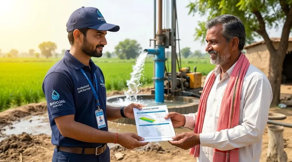
Bhoojal Survey expert delivering GPR survey report with GPS-marked borewell drilling point to satisfied client
Frequently Asked Questions — GPR Surveyor for Borewell and Groundwater Detection
What is the estimated cost of a GPR survey for borewell location in India?
The cost of a GPR Surveyor service depends on the survey area size, depth requirements, and project location. Bhoojal Survey offers competitive pricing with a free initial consultation. Contact us at +91-9691858058 for a customised quote. A professional GPR survey saves you from ₹50,000–₹2,00,000 in borewell failure costs.
How deep can Ground Penetrating Radar (GPR) accurately scan for groundwater?
GPR can scan from a few centimetres to several metres depending on soil and antenna frequency. For borewell location in India, Bhoojal Survey combines GPR with GER Detect and PQWT instruments that identify aquifer zones at 60 to 250+ metres depth — covering all Indian geological formations from shallow alluvial to deep hard rock terrain.
Can GPR detect non-metallic utilities like PVC pipes and clay pipes?
Yes. A professional GPR Surveyor can detect PVC pipes, clay pipes, concrete structures, voids, and other non-metallic underground objects — unlike metal detectors that miss them entirely. This makes pre-drilling GPR scanning essential on built-up properties to prevent accidental damage to existing utilities.
How long does it take to complete a GPR survey and get the report?
Field work for a single residential or agricultural plot typically takes one to two days. The professional GPR survey report is delivered within one to two working days after field completion. For urgent projects, express report delivery within 24 hours can be arranged — call +91-9691858058 to discuss your timeline.
What are the primary benefits of GPR survey over traditional water detection?
GPR survey is non-invasive — no digging, no drilling, no property damage. It is faster, more accurate, and far cheaper than trial excavation. A professional GPR Surveyor provides data-backed recommendations that reduce borewell failure from 30%+ to under 5%, delivering a return on investment that typically exceeds 10x to 30x the survey cost.
Is a GPR survey effective in high-moisture or clay-heavy soils?
GPR signal penetration is reduced in highly conductive clay soils. Bhoojal Survey addresses this by supplementing GPR with GER Detect electrical resistivity and PQWT NMR instruments, which perform effectively in all soil types including high-moisture and clay-heavy formations. Our multi-instrument approach ensures accurate groundwater detection regardless of site conditions.
How accurate is GPR for mapping underground utilities and rebar?
A professional GPR Surveyor can map underground utilities, rebar, voids, and geological boundaries within 5–10% depth accuracy in favourable conditions. Accuracy improves with calibrated instruments and experienced interpretation. Bhoojal Survey's certified team uses industry-standard calibration protocols for the highest available accuracy.
Why should I hire a professional GPR Surveyor instead of renting equipment?
Renting GPR equipment without proper training leads to misinterpretation and wrong drilling decisions — which costs far more than hiring a professional. A certified GPR Surveyor brings geological expertise, calibrated instruments, and a legally valid written report. Bhoojal Survey's hydrogeologists understand Indian geological formations — making your investment worth every rupee.
Can GPR scanning prevent costly damage during construction and borewell drilling?
Yes. A pre-drilling GPR Surveyor scan identifies underground utilities, water lines, cables, and voids before drilling begins. This prevents accidental damage, project delays, and costly legal liability. One GPR scan can save lakhs in repair costs and weeks of project delay.
What information is included in a standard 2D/3D GPR survey report?
Bhoojal Survey's professional GPR survey report includes: GPS-mapped site layout, 2D/3D subsurface profiles, identified water-bearing zones with depth estimates, recommended borewell drilling point with GPS coordinates, expected water yield estimate, instrument data logs, hydrogeologist interpretation notes, and CGWA compliance information. Every report is signed and legally valid for contractor briefings and regulatory submissions.
Don't Risk Your Borewell. Book Your GPR Survey Today.
Every day without scientific data is a day closer to an expensive mistake. Bhoojal Survey's expert GPR Surveyor team is ready to visit your site, scan with India's most advanced instruments, and deliver the written report your drilling contractor needs to succeed on the first drill.
Call +91-9691858058 Now
Book GPR Survey for Borewell
View All Survey Services


