Introduction
Floods are one of the most common and damaging natural disasters in India, affecting millions of people every year. From sudden flash floods in hilly areas to slow-rising river floods in plains, the impact on lives, homes, farms, and infrastructure can be severe. Flood Disaster Management is the science and practice of preparing for, responding to, and reducing the impact of floods. With proper planning, modern technology, and expert flood studies, much of this damage can be prevented. Bhoojal Survey supports this effort by providing scientific flood risk assessments and flood modelling services across India.
What is Flood Disaster Management?
Flood Disaster Management is the process of planning, preparing for, and responding to flood events to reduce loss of life, property damage, and economic disruption. It includes everything from early warning systems and evacuation planning to long-term infrastructure design that accounts for flood risk.
It involves several stakeholders — government agencies, engineers, urban planners, and communities — working together to identify flood-prone areas, build flood-resistant infrastructure, and respond quickly when floods occur.
Why Flood Disaster Management is Important
Floods can happen quickly and without much warning, especially during heavy monsoon rains. Good flood disaster management helps reduce the damage these events cause.
Here's why it matters:
- It saves lives by giving people time to move to safety
- It reduces damage to homes, roads, and farmland
- It helps protect important infrastructure like power plants, hospitals, and airports
- It supports faster recovery after a flood event
- It reduces the financial burden on governments and communities
- It helps India adapt to changing rainfall patterns caused by climate change
Flood-Prone Regions of India
India faces significant flood risk across many states due to monsoon rainfall, river overflow, coastal cyclones, and Himalayan glacial melt. Bhoojal Survey provides flood risk assessment and flood modelling services across the following flood-prone regions:
- Bihar — Frequently affected by floods from the Kosi, Gandak, and Bagmati rivers, especially during monsoon season
- Assam — Annual flooding from the Brahmaputra and Barak river systems affects large areas every year
- Uttar Pradesh — Ganga, Ghaghra, and Rapti river floods impact eastern and central districts during heavy rainfall
- West Bengal — Coastal flooding, cyclones, and overflow from the Ganga-Brahmaputra delta affect southern districts
- Odisha — Cyclones and river flooding from the Mahanadi and Brahmani systems pose recurring risks
- Maharashtra — Urban flooding in cities like Mumbai due to heavy rainfall and drainage overload
- Kerala — Monsoon-driven flash floods and landslides, particularly in hilly and coastal districts
- Madhya Pradesh — River flooding along the Narmada, Tapti, and Betwa during peak monsoon
- Gujarat — Flash floods in low-lying coastal areas and river flooding during cyclonic events
- Uttarakhand and Himachal Pradesh — Flash floods and glacial lake outburst risks in hilly terrain
- Andhra Pradesh and Telangana — Flooding from the Godavari and Krishna river basins during heavy rains
- Delhi NCR — Urban flooding due to drainage overload and Yamuna river overflow during heavy monsoon
Identifying these high-risk regions early allows for better infrastructure planning, drainage design, and disaster preparedness. Bhoojal Survey conducts site-specific flood risk assessments and flood modelling studies in these and other regions across India to help projects plan for flood-safe development.
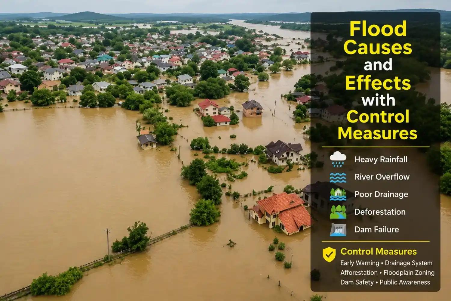
Major Causes of Flood Disasters
Understanding why floods happen is the first step toward managing them. Common causes include:
- Heavy or prolonged rainfall — especially during monsoon season
- River overflow — when rivers receive more water than their channels can hold
- Poor drainage systems — especially in cities where stormwater cannot flow away quickly
- Dam or embankment failure — sudden release of large volumes of water
- Deforestation and land use change — reduces the land's ability to absorb water
- Urbanisation — concrete surfaces increase runoff and reduce natural absorption
- Climate change — leading to more intense and unpredictable rainfall events
Key Stages of Flood Disaster Management
Flood disaster management is usually divided into four main stages:
- Prevention and Mitigation — Identifying flood-prone areas and building infrastructure designed to reduce flood impact, such as embankments, drainage channels, and flood barriers.
- Preparedness — Creating flood warning systems, evacuation plans, and training communities on what to do during a flood.
- Response — Emergency actions taken during a flood, including rescue operations, relief distribution, and temporary shelter.
- Recovery — Rebuilding homes, infrastructure, and livelihoods after the flood, often guided by lessons learned for future planning.
What is Flood Risk Assessment?
Flood Risk Assessment is a study that identifies how likely an area is to flood, how severe the flooding could be, and what impact it would have on people, property, and infrastructure. It combines rainfall data, terrain information, and historical flood records to estimate flood probability and severity.
This assessment is often required before construction projects begin, especially for sites located near rivers, low-lying areas, or drainage channels.
What is Flood Modelling?
Flood Modelling is the use of computer simulations to predict how floodwater will move across a landscape during a rainfall or river flood event. It calculates flood depth, flow velocity, and the area that will be covered by water under different rainfall scenarios.
Flood models help engineers and planners understand exactly where water will go, how deep it will get, and how long it will stay — information that is essential for designing safe infrastructure.
How Flood Disaster Management is Related to Flood Modelling
Flood modelling is the scientific foundation of modern flood disaster management. Without accurate flood models, disaster management plans would be based on guesswork rather than data.
Here's how the two are connected:
- Flood models predict which areas are likely to flood, how deep the water will get, and how fast it will arrive
- This information helps disaster management teams identify high-risk zones in advance
- Emergency response plans can be designed around realistic flood scenarios, rather than assumptions
- Hydraulic modelling shows how water will behave around bridges, roads, and buildings
- Hydrological modelling shows how much runoff a catchment will produce during heavy rainfall
- Simulations of different rainfall events — including extreme and rare events — help planners prepare for worst-case scenarios
- Accurate flood models reduce future flood losses by guiding better drainage design, land use planning, and early warning thresholds
In short, flood disaster management decisions are only as good as the flood data behind them. Reliable flood modelling ensures that preparedness plans, infrastructure designs, and emergency responses are based on real, site-specific information.
Technologies Used in Modern Flood Management
Several technologies work together to improve flood disaster management:
- Flood Modelling Software (such as HEC-RAS and HEC-HMS) — used to simulate flood behaviour and predict flood depths and extents
- Digital Elevation Models (DEM/DTM) — high-resolution terrain data that forms the base for accurate flood mapping
- GIS Mapping — used to visualise flood-prone zones, drainage networks, and infrastructure at risk
- Rainfall and River Gauging Data — real-time and historical data used to calibrate flood models and support early warning systems
- Flood Forecasting Systems — combine weather forecasts with hydrological models to predict flood timing and severity
- Remote Sensing and Satellite Data — used to monitor flood extent during and after flood events
How Bhoojal Survey Helps in Flood Disaster Management
Bhoojal Survey provides scientific flood studies that support better flood disaster management decisions for industries, infrastructure developers, and government projects across India.
Our services include:
- Flood Risk Assessment — identifying flood-prone zones and estimating flood probability for a given site
- Flood Modelling — using HEC-RAS and HEC-HMS to simulate flood depth, velocity, and inundation extent
- Hydraulic and Hydrological Modelling — analysing how rainfall converts to runoff and how that water moves across the land
- Flood Inundation and Flood Hazard Mapping — producing detailed maps showing flood-affected areas under different scenarios
- Area Flood Drainage Studies (AFDS) — assessing drainage capacity and design requirements for a specific site
- Stormwater Drainage Planning — designing drainage systems that can handle peak rainfall events
- Floodplain Analysis — studying the behaviour of rivers and floodplains to guide safe development
Here's how this supports different types of projects:
- Airports — Runway flood risk assessment and drainage planning to keep operations safe during heavy rainfall
- Solar Power Plants — Site-specific flood risk evaluation and AFDS studies to protect panels and equipment from waterlogging
- Highways and Railways — Flood impact assessment and cross-drainage planning to prevent road and track damage
- Industrial Projects — Flood protection planning and stormwater management to safeguard plant operations
- Residential and Township Projects — Flood-safe layout planning to protect homes and community infrastructure from waterlogging
By combining accurate flood modelling with practical drainage and infrastructure planning, Bhoojal Survey helps clients reduce flood risk before it becomes a costly problem.
Benefits of Scientific Flood Planning
Investing in proper flood studies before construction offers long-term advantages:
- Reduces the risk of flood damage to buildings, roads, and equipment
- Lowers long-term maintenance and repair costs
- Supports faster regulatory approvals by meeting environmental compliance requirements
- Improves safety for workers, residents, and the surrounding community
- Helps design infrastructure that can handle future climate conditions
- Builds long-term resilience against increasingly unpredictable rainfall patterns
Conclusion
Flood Disaster Management is essential for protecting lives, property, and infrastructure in a country as flood-prone as India. At its core, effective flood management depends on accurate flood modelling and flood risk assessment — without reliable data, preparedness and response plans cannot work as intended.
Bhoojal Survey supports this process by providing detailed flood modelling, flood risk assessment, and drainage planning services tailored to airports, solar plants, highways, industrial sites, and residential developments across India. Scientific flood planning today means safer, more resilient infrastructure tomorrow.
Frequently Asked Questions
Q: How to manage flood?
Flood management involves a mix of prevention, preparedness, and response actions. This includes building proper drainage systems, embankments, and flood barriers, along with early warning systems, evacuation plans, and community awareness. Scientific flood modelling helps identify high-risk zones so resources can be directed where they're needed most.
Q: How can we manage floods?
Floods can be managed through better infrastructure planning (like improved stormwater drainage and elevated construction in low-lying areas), real-time monitoring of rainfall and river levels, flood forecasting systems, and coordinated emergency response between government agencies and local communities. Long-term land use planning that avoids building in high-risk floodplains also plays a key role.
Q: How can floods be managed?
Floods can be managed by combining structural measures (dams, embankments, drainage channels) with non-structural measures (early warning systems, zoning regulations, public awareness campaigns). Flood risk assessments and flood models help engineers design these systems based on actual site data rather than guesswork, making the overall plan more effective.
Q: How to manage flood disaster?
Managing a flood disaster involves four key stages: prevention (reducing risk through infrastructure and planning), preparedness (warning systems and evacuation plans), response (rescue and relief during the flood), and recovery (rebuilding afterward). Each stage works better when supported by accurate flood modelling and risk data, which helps authorities act quickly and target resources to the areas that need them most.
To understand the complete technical process and tools behind this, read our detailed guide on Flood Modeller.