What is Flood Modeling?
Definition — Flood Modeling:
Flood modeling is the scientific process of using computer simulations to predict how floodwater behaves across a given terrain under various rainfall and river flow scenarios. Using input data such as topography, rainfall records, land use, and soil characteristics, flood models calculate flood depths, flow velocities, inundation extents, and flood duration — giving engineers and planners a quantitative basis for flood risk management decisions.
For any industrial facility, infrastructure project, or urban development, understanding flood risk before construction begins is not optional — it is a regulatory and safety imperative. A well-constructed flood model identifies which areas of a site will be inundated during a peak rainfall or 100-year return period flood event, how fast floodwater will arrive, how deep it will become, and how long it will persist. This data directly informs drainage design, site elevation decisions, emergency response planning, and Environmental Impact Assessment (EIA) documentation.
At Bhoojal Survey, we specialise in numerical flood modeling using HEC-RAS and HEC-HMS software, integrated with high-resolution Digital Terrain Models (DTM), meteorological data, geological runoff analysis, and GIS-based floodplain mapping. Our flood models are used by industrial clients, infrastructure developers, government bodies, and PSUs across India.
Quick Facts — Flood Modeling:
- Primary software: HEC-RAS (hydraulic), HEC-HMS (hydrological), GIS floodplain mapping
- Key inputs: DTM/DEM, rainfall data, land use maps, soil data, river surveys
- Outputs: Flood depth maps, velocity maps, inundation extent, flood hydrographs
- Project timelines: 2–4 weeks (site-level) to 2–4 months (catchment-level)
- Regulatory use: Required for EIA, MoEFCC clearance, CGWA compliance, and NDMA guidelines
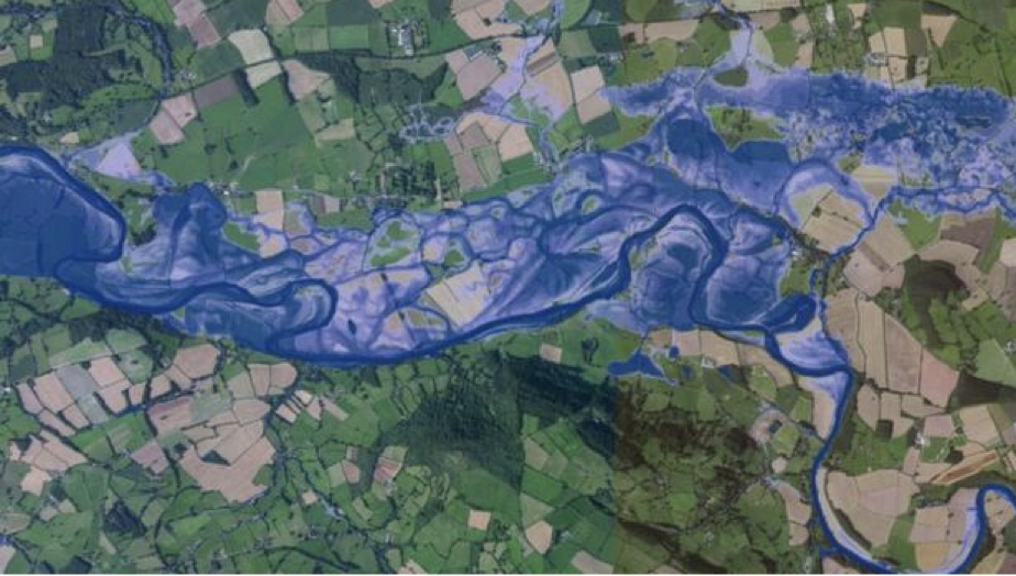
HEC-RAS Flood Modeling — Simulation Showing Water-Affected Zones During Peak Rainfall
How Does Flood Modeling Work? — The Two-Stage Process
A complete flood study at Bhoojal Survey involves two integrated scientific stages:
Stage 1 — Hydrologic Modeling (HEC-HMS)
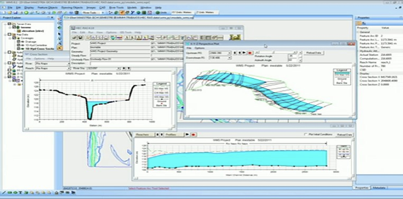
Hydrologic modeling quantifies how much runoff is generated by rainfall within a catchment. Using HEC-HMS software, we analyse precipitation intensity and duration, catchment area and shape, soil infiltration rates, land use and surface cover, and antecedent moisture conditions. The output is a flood hydrograph — a time-series graph of peak flow rates at the point of interest. This tells us how much water will enter the drainage system or river channel under a given storm event.
Stage 2 — Hydraulic Modeling (HEC-RAS)
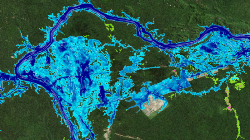
Hydraulic modeling takes the peak flow rates from the hydrologic stage and simulates how that water moves through the physical landscape. Using HEC-RAS integrated with a high-resolution DTM, we compute water surface profiles, flood depths at every point across the floodplain, flow velocities, areas of inundation, and the behaviour of water around structures such as bridges, culverts, roads, and buildings. The result is a detailed floodplain inundation map and flood risk assessment.
Key Takeaway — Flood Modeling Process:
Hydrologic modeling (HEC-HMS) answers "How much water?" — Hydraulic modeling (HEC-RAS) answers "Where does it go and how deep does it get?" Both stages are required for a complete, defensible flood risk assessment.
Our Flood Modeling Service Areas
Bhoojal Survey provides a comprehensive range of flood modeling and flood risk assessment services for industrial, infrastructure, government, and private sector clients across India:
- Dam Failure Impact Assessment — Simulating worst-case inundation scenarios downstream of existing or proposed dams, used for emergency action planning and dam safety documentation.
- Flood Impact Assessment for Development Feasibility — Pre-construction flood risk quantification for industrial sites, real estate projects, and infrastructure developments.
- Catchment Management Studies — Hydrological analysis of entire river catchments to understand runoff behaviour, identify flood-prone zones, and design catchment-level interventions.
- Floodplain Risk Management Studies — Damage and safety analysis for existing communities and infrastructure in flood-prone areas, including economic loss estimation.
- Flood Mitigation Option Investigations — Hydraulic assessment of proposed flood control measures including retention ponds, diversion channels, embankments, and upgraded drainage.
- Flood Warning System Design — Thresholds and trigger levels for community flood early warning systems based on rainfall and river level monitoring.
- Historical Flood Analysis and Stream Gauging — Reconstruction of past flood events using historical records and field data to calibrate models and validate return period estimates.
- Sizing of Hydraulic Structures — Design flood calculations for bridges, culverts, spillways, and other hydraulic structures to ensure adequate capacity under peak flow conditions.
- Hydrographic Survey — River cross-section surveys, channel bathymetry, and floodplain topographic surveys providing geometric input data for hydraulic models.
- Urban and Rural Catchment Flood Investigations — Stormwater modeling for urban drainage systems and rural catchments, addressing both pluvial (surface water) and fluvial (river) flood mechanisms.
- 3D Flood Rendering and Animation — Visual communication of flood simulation results for stakeholder presentations, public consultations, and government submissions.
Flood Modeling for Industry — Who Needs a Flood Risk Assessment?
Flood modeling services are required across a wide range of industries and project types in India:
Industrial & Manufacturing
Pre-construction flood risk for factories, plants, and warehouses in flood-prone zones
Infrastructure & Roads
Hydraulic design for bridges, culverts, and road drainage in river floodplains
Mining
Flood impact assessment and mine drainage design for opencast and underground operations
Real Estate & Township
Flood risk for housing projects and township developments near rivers or drainage channels
Government & PSU Projects
EIA, MoEFCC, NDMA, and CGWA compliance documentation requiring hydrological analysis
Dams & Irrigation
Dam safety, spillway design flood, and downstream inundation mapping
Urban Planning & Smart Cities
Stormwater master planning and surface water flood mapping for urban areas
Climate Change Adaptation
Future flood scenario modeling under projected climate change rainfall intensities
Why Choose Bhoojal Survey for Flood Modeling in India?
- 25+ years of active field and modeling experience across diverse Indian geographies — from the Deccan Plateau to the Indo-Gangetic Plain and Himalayan foothills
- HEC-RAS & HEC-HMS proficiency — industry-standard hydraulic and hydrological modeling software used by NDMA, CWPRS, and international flood agencies
- High-resolution DTM integration — we use latest-generation topographic data (LiDAR, SRTM, Cartosat) for accurate floodplain delineation
- Regulatory-compliant reports — output formats accepted for EIA, MoEFCC environmental clearance, CGWA NOC, and government project documentation
- 1,170+ completed projects for clients including Adani, IOCL, HPCL, Tata Projects, Coal India, NTPC, and GR Infra
- End-to-end service — from field hydrographic survey and data collection through to model calibration, results interpretation, 3D visualisation, and stakeholder reporting
- Pan-India coverage — active project delivery across MP, Maharashtra, Gujarat, Rajasthan, UP, Odisha, Karnataka, and Delhi NCR
Flood Modeling Services Across India — Regional Coverage
Bhoojal Survey delivers flood modeling and flood risk assessment services across the following states and regions:
Andhra Pradesh — Visakhapatnam, Vijayawada, Guntur, Nellore, Tirupati, and surrounding districts
Major Cities — Key urban centers and flood-prone metropolitan areas across India
Gujarat — Ahmedabad, Surat, Vadodara, Patan, Rajkot, and surrounding districts
Madhya Pradesh — Indore, Bhopal, Jabalpur, Ujjain, Neemuch, Jhabua, and surrounding districts
India Services — Comprehensive nationwide flood risk assessment and hydraulic modeling
Uttar Pradesh — Lucknow, Kanpur, Ghaziabad, Agra, Varanasi, Noida, and surrounding districts
West Bengal — Kolkata, Asansol, Siliguri, Durgapur, Bardhaman, and surrounding districts
Bihar — Patna, Gaya, Bhagalpur, Muzaffarpur, and surrounding districts
Jharkhand — Ranchi, Jamshedpur, Dhanbad, Bokaro, Deoghar, and surrounding districts
Frequently Asked Questions — Flood Modeling Services
What is flood modeling?
Flood modeling is the process of using computer simulations — such as HEC-RAS and HEC-HMS — to predict how floodwater behaves across a given terrain. It uses rainfall data, topography, soil types, and land use to estimate flood depths, velocities, and extents, helping engineers design flood defenses and emergency response systems.
Why is flood modeling important for industrial projects?
Industrial and infrastructure projects in or near flood-prone areas must quantify flood risk before construction. Flood modeling identifies inundation zones, informs drainage design, ensures worker safety, and produces the regulatory documentation required for EIA and environmental clearance from MoEFCC and state PCBs.
What software does Bhoojal Survey use for flood modeling?
We use HEC-RAS for hydraulic flood modeling and HEC-HMS for hydrological analysis, integrated with GIS tools (ArcGIS / QGIS) for floodplain mapping. High-resolution Digital Terrain Models (DTM/DEM) from LiDAR, Cartosat, or SRTM data are used as the topographic base.
What data is required for a flood modeling study?
Required inputs include: Digital Terrain Model (DTM/DEM), historical rainfall records, land use and land cover maps, soil type and infiltration data, river cross-section survey data, existing infrastructure information, and IMD meteorological data for design storm estimation.
How accurate are flood models?
Flood model accuracy depends on the resolution and quality of input data and the calibration of the model against observed flood events. When calibrated with historical gauge data and high-resolution topography, HEC-RAS models can predict flood extents and depths within ±10–15% of observed values. All models carry some level of uncertainty, which is documented in our reports.
Can flood models predict flash floods?
Yes. Flash flood prediction requires high-resolution temporal rainfall data and fast hydrological routing. Bhoojal Survey uses event-based hydrological models configured for short-duration, high-intensity rainfall scenarios typical of Indian monsoon flash flood events in hilly terrain and urban catchments.
How long does a flood modeling project take?
A site-level flood impact assessment typically takes 2–4 weeks from data collection to final report. A comprehensive catchment flood study covering a large river system or involving dam failure analysis may take 2–4 months. Timeline depends on data availability, study area size, and the number of scenarios required.
Is flood modeling required for EIA or environmental clearance in India?
Yes. Flood risk assessment and hydrological analysis are required components of EIA reports for industries and infrastructure located in or near flood-prone areas. MoEFCC, state PCBs, and CGWA require this documentation as part of environmental clearance and NOC applications.
Can flood modeling help with climate change adaptation?
Yes. We develop future flood scenarios using projected increases in rainfall intensity under climate change conditions (RCP 4.5 and RCP 8.5 scenarios). This helps clients and planners understand how flood risk will evolve over the project lifecycle and design resilient infrastructure accordingly.
What is the cost of flood modeling services in India?
Flood modeling costs vary based on project scope, study area size, data requirements, and the number of flood scenarios required. Contact Bhoojal Survey for a project-specific consultation and fee estimate. We offer the most competitive consulting fees in India without compromising on technical quality.
Voice Search — Quick Answers About Flood Modeling
What does a flood modeling company do?
A flood modeling company uses computer simulations to predict how and where floodwater will travel during heavy rainfall or river flooding. They produce floodplain maps, flood depth estimates, and risk assessments that help engineers, developers, and governments design flood defenses and make safer planning decisions.
How do I get a flood model done for my industrial site in India?
Contact Bhoojal Survey at +91-9691858058 or
[email protected]. We will assess your site requirements, collect topographic and hydrological data, build and run a calibrated HEC-RAS flood model, and deliver a detailed flood risk assessment report suitable for EIA and regulatory submissions.
Which software is used for flood modeling in India?
The most widely used flood modeling software in India is HEC-RAS for hydraulic analysis and HEC-HMS for hydrological modeling — both developed by the US Army Corps of Engineers and accepted by Indian regulatory bodies including NDMA, CWPRS, and state flood control departments.
Related Services from Bhoojal Survey:


