What is a Flood Modeller?
A Flood Modeller is a software tool and professional service used to simulate, analyse, and predict how floodwater moves across land, rivers, and urban areas.
It helps engineers, planners, and government agencies understand:
- Where floods are likely to occur
- How deep the water can get
- How fast floodwater travels
- Which areas are at high risk
Flood Modeller is also the name of a widely used hydraulic modelling software developed by Jacobs and the UK Environment Agency.
What Does a Flood Modeller Do?
A flood modeller — the professional — uses software and data to build digital models of rivers, drains, and floodplains.
Their core responsibilities include:
- Collecting rainfall and river flow data
- Building 1D and 2D hydraulic models
- Running flood simulations for different storm scenarios
- Producing flood risk maps and reports
- Supporting infrastructure planning and environmental assessments
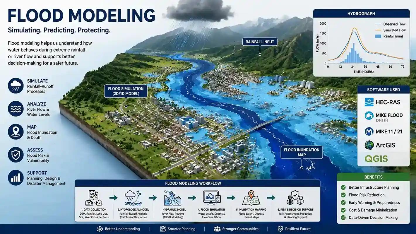
How Does Flood Modelling Work?
Flood modelling works by combining real-world data with mathematical equations to simulate water movement.
The key steps involved are:
- Data Collection — rainfall data, river levels, terrain elevation (DEM/LiDAR)
- Model Building — creating a digital representation of the area
- Simulation — running the model for different flood events (1-in-10, 1-in-100 year floods)
- Results Analysis — reviewing flood depths, velocities, and extents
- Reporting — preparing flood risk assessments and hazard maps
Key Flood Modelling Software Tools
Several powerful software tools are used by flood modellers worldwide:
- Flood Modeller Pro — widely used in the UK and internationally for 1D/2D modelling
- HEC-RAS — free software by the US Army Corps of Engineers
- MIKE FLOOD — advanced tool by DHI for complex coastal and urban modelling
- SWMM — used for urban stormwater and drainage modelling
- TUFLOW — popular for 2D floodplain modelling in Australia and globally
Who Needs Flood Modelling Services?
Flood modelling is essential for a wide range of projects and industries:
- Infrastructure developers — airports, highways, railways, solar plants
- Urban planners — smart cities, residential townships, industrial parks
- Government agencies — flood zone mapping, disaster management
- Environmental consultants — environmental impact assessments
- Insurance companies — flood risk evaluation for properties
Why is Flood Modelling Important?
Flood modelling plays a critical role in protecting lives, assets, and infrastructure.
Key reasons it matters:
- Helps identify flood-prone zones before construction begins
- Supports regulatory compliance and planning approvals
- Reduces financial losses from flood damage
- Improves emergency response planning
- Enables climate-resilient infrastructure design
Flood Modelling in India
India faces significant flood risks across many states including Madhya Pradesh, Assam, Bihar, Odisha, and Maharashtra.
Professional flood modelling services in India are used for:
- National Highway flood impact assessments
- Urban drainage master plans
- River widening and restoration projects
- Solar and industrial park site evaluations
- Smart city flood resilience planning
1D vs 2D Flood Modelling
1D Flood Modelling:
- Models water flow along a single channel or pipe
- Faster to run, suitable for rivers and drainage networks
- Less accurate for complex floodplain areas
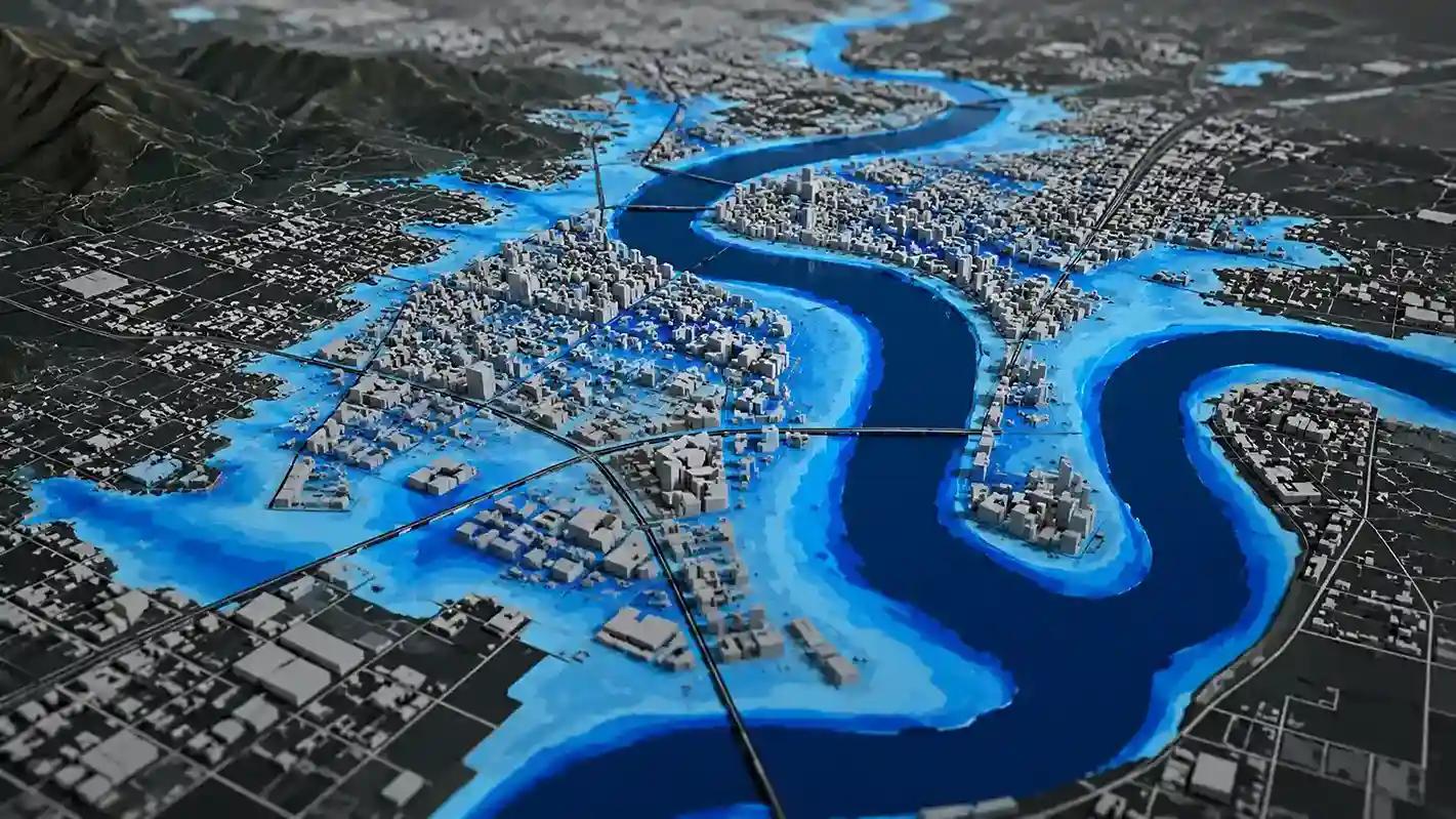
2D Flood Modelling:
- Simulates floodwater spreading across a landscape
- Highly accurate for urban areas and floodplains
- Requires more data and processing time
Most modern projects use a combined 1D-2D approach for best results.
How Bhoojal Survey Helps in Flood Modelling
Bhoojal Survey provides end-to-end professional flood modelling and risk assessment services across India. With over 30+ years of expertise and advanced technical tools, we help infrastructure projects, industries, and solar parks stay safe and compliant.
Here is how we assist you:
- Advanced 1D & 2D Simulation: We use industry-leading software like HEC-RAS and TUFLOW to simulate complex flood scenarios and predict water flow with high accuracy.
- Catchment & Rainfall Analysis: Our hydrogeological experts analyze historical rainfall data and terrain elevation (DEM/LiDAR) to design foolproof drainage master plans.
- Regulatory Compliance & NOCs: We prepare detailed Flood Risk Assessment (FRA) reports that are mandatory for securing government clearances and CGWA NOCs.
- Site Feasibility for Solar & Industrial Parks: Before you invest, we evaluate your site to ensure your critical infrastructure is built well above the maximum flood level (HFL).
FAQs – Flood Modeller
Q1. What is the difference between flood modelling and flood risk assessment? Flood modelling is the process of simulating floodwater behaviour using software. Flood risk assessment is the broader evaluation of flood probability, consequences, and mitigation options. Flood modelling is one key part of a complete flood risk assessment.
Q2. Which software is best for flood modelling? The best software depends on the project. Flood Modeller Pro and HEC-RAS are excellent for river modelling. MIKE FLOOD suits complex coastal projects. TUFLOW is preferred for 2D floodplain work. Most consultants choose based on project type, data availability, and client requirements.
Q3. How long does a flood modelling study take? A basic flood modelling study can take two to four weeks. Complex projects involving large river systems, multiple scenarios, or urban drainage can take two to six months depending on data availability and project scope.
Q4. Is flood modelling mandatory for construction projects in India? Flood modelling is increasingly required for projects near rivers, floodplains, and low-lying areas. It is often mandated under Environmental Impact Assessment regulations, NHAI guidelines for highways, and state-level urban planning bylaws.
Q5. What data is needed for flood modelling? Key data requirements include digital elevation models (DEM or LiDAR), historical rainfall and river flow records, land use maps, soil type data, drainage network details, and hydraulic structure information such as bridges and culverts.
Q6. Can flood modelling predict exact flood levels? Flood modelling provides probabilistic estimates, not exact predictions. Results depend on data quality and model assumptions. Good models give reliable flood extent and depth estimates for planning and design purposes, but real flood events can vary due to unpredictable rainfall and land changes.