Water Shortage? Need a Hydrological Survey
Access to reliable water is one of the most critical challenges facing industries, agriculture, and infrastructure development in India today. Rapid urbanisation, erratic rainfall, and increasing groundwater depletion are putting enormous pressure on available water resources. Without a clear scientific understanding of where water exists, how it moves, and how much is available, any water-dependent project carries significant risk.
A water resource hydrological survey provides exactly that understanding. It is a structured scientific investigation that maps, measures, and analyses both surface water and groundwater systems across a defined area. From identifying viable aquifer zones to assessing seasonal recharge rates, hydrological surveys form the foundation of informed water resource planning. Bhoojal Survey brings over a decade of hands-on field experience to every investigation, delivering precise data that guides confident decision-making.
What is a Water Resource Hydrological Survey?
A water resource hydrological survey is a comprehensive scientific study of the water cycle within a specific geographic region. It examines rainfall patterns, surface runoff, streamflow, groundwater levels, aquifer properties, and recharge mechanisms to produce a complete hydrological profile of the area.
The primary purpose of such an investigation is to answer three essential questions: Where is the water?
How much is available? Is it sustainable for the intended use? Whether the project involves drilling borewells for an industrial facility, planning an irrigation scheme, or designing a watershed management programme, the hydrological survey provides the technical evidence base that drives every subsequent decision.
Why Water Resource Hydrological Survey is Important
India faces a growing water stress crisis. According to the Central Ground Water Board (CGWB), more than 60 percent of districts in the country report declining groundwater levels. For infrastructure developers, mining companies, and agricultural planners, proceeding without a proper hydrological investigation is not just risky — it can lead to project failure, regulatory non-compliance, and significant financial loss.
A professional hydrological investigation for water resource planning ensures that every project is built on a reliable understanding of local water availability, reducing uncertainty and improving long-term outcomes.
Methods Used in Water Resource Hydrological Survey
Modern hydrological survey services draw on a combination of field techniques, remote sensing technologies, and advanced geophysical instruments. The methodology is always tailored to the specific project requirements, terrain characteristics, and target water resource objectives.
Hydrogeological Investigation
Systematic field mapping of rock formations, soil profiles, and geological structures to understand how geology controls groundwater occurrence and movement.
Watershed Survey & Analysis
Delineation of catchment boundaries, drainage networks, and runoff pathways to assess surface water availability and recharge potential.
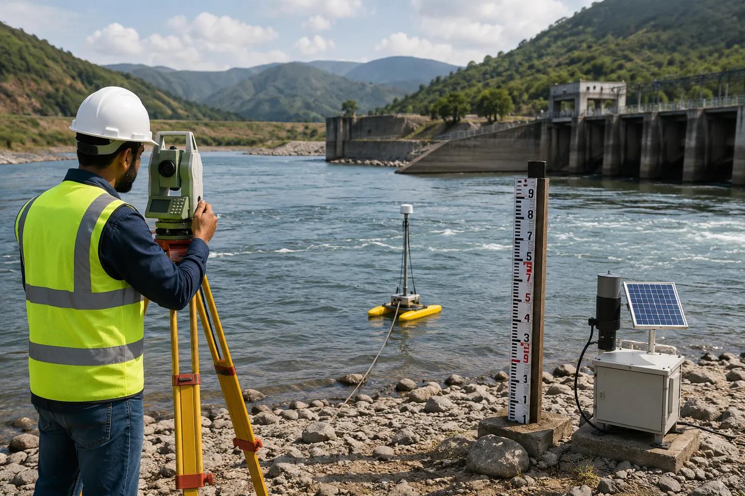
Geophysical Groundwater Survey
Bhoojal Survey conducts hydrogeological surveys using SSRMPATS instruments, GER DETECT, and
PQWT at site for open well and borewell location identification — enabling precise subsurface imaging without invasive drilling.
Satellite Remote Sensing & GIS Mapping
Multi-spectral satellite imagery combined with Geographic Information System (GIS) analysis provides large-area scientific water resource mapping, identifying lineaments, fractured zones, and potential recharge areas.
Aquifer Investigation & Testing
Pumping tests, slug tests, and water level monitoring programmes establish aquifer transmissivity, storage coefficients, and sustainable yield parameters.
Instrument Highlight: Bhoojal Survey conducts hydrogeological survey using SSRMPATS Instrument, GER DETECT, and PQWT at site for open well / borewell location — combining advanced geophysical science with practical field expertise.
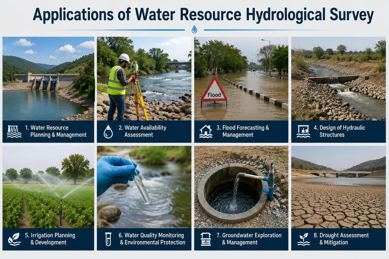
Applications of Water Resource Hydrological Survey
A scientific groundwater and watershed survey supports a wide range of sectors and project types across India.
Industrial Water Resource PlanningAgricultural Irrigation Projects
Factories, power plants, and processing facilitiesIrrigation scheme designers rely on hydrological require dependable water supply assessments beforeanalysis to optimise canal layouts, borewell placement, site selection and regulatory approval.and seasonal water availability planning.
Mining & Infrastructure ProjectsCommercial Water Supply Systems
Mining operations need groundwater dewatering plansReal estate developers and commercial complexes and surface water impact assessments. Infrastructurecommission surveys to identify sustainable water developers require drainage and flood risk data.sources for long-term operational needs.
Government Water Management ProjectsGroundwater Recharge Projects
State and central government agencies useRecharge well design, check dam siting, and hydrological survey data for watershed managementpercolation pond planning all require detailed programmes, Jal Shakti initiatives, and groundwatergroundwater recharge assessment and aquifer regulation.mapping.
Why Choose Bhoojal Survey
Bhoojal Survey is a trusted hydrological survey company in India with deep technical expertise in groundwater and hydrology consultancy services. Our team of experienced hydrologists and hydrogeologists has successfully delivered surveys for industrial, agricultural, government, and infrastructure clients across multiple states.
- Experienced hydrologists and groundwater specialists with pan-India project exposure
- Advanced instruments: SSRMPATS, GER DETECT, PQWT, and GIS-based mapping platforms
- Accurate and reproducible groundwater and watershed analysis backed by field data
- Fast turnaround on technical reports with actionable water resource management recommendations
- Customised survey packages for industrial, agricultural, mining, and government projects
- End-to-end service from site reconnaissance to final hydrogeological report submission
Whether you require a standalone aquifer investigation survey, a full watershed management analysis, or a turnkey water resource management survey for a large infrastructure project, Bhoojal Survey delivers reliable science and clear professional guidance.
Conclusion
Water is not a guaranteed resource — it must be scientifically understood before it can be reliably used. A professional water resource hydrological survey provides the technical foundation that every water-dependent project requires: accurate data, sustainable planning, and regulatory confidence. Skipping this step risks costly project failures, water supply shortfalls, and environmental non-compliance.
Bhoojal Survey combines advanced geophysical technology with experienced hydrological expertise to deliver surveys that are precise, practical, and project-specific. From groundwater recharge assessment to full watershed survey programmes, we provide the scientific groundwater investigation and water resource analysis your project demands.
FAQs – Water Resource Hydrological Survey
Q: What is a water resource hydrological survey?
A water resource hydrological survey is a structured scientific investigation that maps and analyses surface water and groundwater systems in a defined area. It examines rainfall, runoff, groundwater levels, aquifer properties, and recharge mechanisms to produce a comprehensive water resource profile used for planning and management decisions.
Q: Why is hydrological investigation important for projects?
Without hydrological investigation, infrastructure, industrial, or agricultural projects cannot reliably assess water availability, regulatory compliance requirements, or long-term supply security. A scientific survey reduces project risk and supports evidence-based decision-making from the earliest planning stages.
Q: How is groundwater assessed scientifically?
Groundwater is assessed using a combination of geophysical surveys (including instruments such as SSRMPATS, GER DETECT, and PQWT), borewell logging, aquifer pump testing, water level monitoring, and GIS-based hydrogeological mapping. These methods provide precise data on groundwater depth, distribution, and sustainable yield.
Q: What methods are used in hydrological surveys?
Key methods include hydrogeological field mapping, watershed delineation, geophysical resistivity and electromagnetic surveys, satellite remote sensing, GIS analysis, aquifer testing, and water quality sampling. The combination of methods is selected based on project scope, terrain, and target water resource objectives.
Q: What industries require water resource hydrological surveys?
Industries that commonly commission hydrological surveys include manufacturing and processing facilities, mining companies, real estate and commercial developers, agricultural irrigation projects, government water departments, environmental consultancies, and infrastructure development companies.
Q: How long does a hydrological survey take?
Survey duration depends on the area size, project complexity, and required depth of investigation. A targeted borewell location survey may be completed in one to three days, while a full watershed and groundwater resource assessment for a large project may require two to six weeks including fieldwork, laboratory analysis, and reporting.
Q: Does Bhoojal Survey provide services across all of India?
Yes. Bhoojal Survey provides professional water resource hydrological survey and groundwater investigation services across India, covering industrial, agricultural, government, and infrastructure project requirements in multiple states and terrains.
Q: What deliverables are included in a hydrological survey report?
A comprehensive survey report typically includes hydrogeological maps, aquifer cross-sections, groundwater level data, recharge assessment findings, recommended borewell or open-well locations, water resource management recommendations, and a technical summary for regulatory or planning submission.