Satellite Topographic Survey:Modern Infrastructure
In today's rapidly evolving infrastructure landscape, accurate terrain data is not a luxury — it is a foundation. A Satellite Topographic Survey leverages advanced earth observation satellites, remote sensing technology, and GIS-based terrain analysis to deliver precise elevation, contour, and landform data across vast geographical areas. From highway alignments to solar power plant development, from mining excavation to smart city planning, satellite terrain mapping has become indispensable for engineering and infrastructure projects across India.
Unlike conventional ground surveys that are time-consuming and limited in area coverage, satellite-based topographic surveys can capture complete terrain profiles of hundreds of square kilometres with high spatial accuracy. By integrating digital elevation models (DEM), GIS topographic mapping, and remote sensing terrain analysis, these surveys provide actionable geospatial data that drives smarter project decisions and faster execution.
What is a Satellite Topographic Survey?
A satellite topographic survey is a geospatial mapping process in which earth observation satellites capture high-resolution terrain imagery, which is then processed to generate accurate elevation maps, contour lines, slope profiles, and 3D terrain models of a specific area.
At its core, the process relies on three key technologies:
- Remote Sensing: Satellites equipped with multispectral and synthetic aperture radar (SAR) sensors collect raw terrain data.
- Digital Elevation Models (DEM): Processed satellite data is converted into precise elevation grids representing the earth's surface.
- GIS Integration: Elevation data is layered with spatial databases for comprehensive terrain visualisation, analysis, and engineering planning.
This combination of satellite terrain mapping, GIS topographic mapping, and digital elevation modelling provides engineers, planners, and project developers with a scientifically reliable picture of the terrain before any ground activity begins.
Why Satellite Topographic Surveys Are Important
The importance of satellite-based terrain mapping extends across project planning, design, and execution phases. Here is why modern infrastructure projects across India depend on professional satellite topographic survey services:
Advantage
Project Impact
Large-area coverage in a single survey
Covers 100s of sq.km efficiently
High-resolution elevation data
Precise slope and contour analysis
Faster data acquisition
Reduces survey timelines by 60–70%
Reduced fieldwork costs
Lower project survey expenditure
GIS-integrated terrain visualisation
Better engineering decision-making
Repeatable and verifiable data
Reliable for multi-stage projects
Applications of Satellite Topographic Survey
Satellite terrain mapping and GIS elevation data mapping are applied across a wide range of industries and engineering disciplines. The following are key application areas where Bhoojal Survey's satellite topographic survey services deliver measurable value:
■ Highway and Road Planning
Satellite land contour mapping enables corridor analysis, gradient profiling, and route optimisation for National Highways, state roads, and rural connectivity projects — without time-consuming ground traverses.
■ Mining and Excavation Projects
Pre-mining satellite elevation mapping identifies natural terrain features, calculates cut-and-fill volumes, and supports safe excavation planning in complex topographies.
■ Solar Power Plant Development
GIS topographic survey services help solar developers assess terrain slope, orientation, and shadow analysis — critical for optimal panel placement and generation efficiency.
■ Urban Development and Smart Cities
Satellite geographic mapping supports master planning, drainage design, and infrastructure layout for smart city initiatives and urban expansion projects.
■ Watershed and Drainage Planning
Remote sensing topographic mapping precisely delineates watershed boundaries, flow directions, and drainage basins essential for water resource and flood management studies.
■ Airport and Railway Infrastructure
Large-scale satellite surface mapping supports site selection, terrain profiling, and earthwork estimation for greenfield airports and new railway alignments.
■ Environmental Monitoring
Satellite landform analysis enables change detection, erosion monitoring, and land-use classification for environmental impact assessments and ecological studies.
■ Industrial Land Development
Geospatial terrain analysis identifies suitable flat zones, problematic terrain, and land gradient issues for industrial parks, logistics hubs, and infrastructure zones.
Methods Used in Satellite Topographic Survey
Remote Sensing Terrain Mapping
Remote sensing terrain mapping involves acquiring land surface data using satellite-borne sensors orbiting the earth. Optical sensors capture multispectral images reflecting terrain texture, vegetation, and land cover, while SAR (Synthetic Aperture Radar) sensors penetrate cloud cover to capture topographic data in all weather conditions. Earth observation platforms such as Sentinel, SRTM, CARTOSAT, and ALOS PALSAR provide high-resolution geospatial terrain data for professional survey applications across India.
GIS-Based Terrain Analysis
GIS topographic mapping integrates satellite-derived elevation data with spatial databases to produce detailed terrain models, slope maps, and aspect analysis. Bhoojal Survey's GIS team processes raw satellite data using industry-standard geospatial platforms to deliver precise contour maps, land-use overlays, and terrain visualisation outputs tailored to each project's engineering requirements.
Digital Elevation Model (DEM) Analysis
A Digital Elevation Model (DEM) is a 3D representation of the terrain surface derived from satellite elevation data. DEMs are the backbone of satellite-based terrain surveys — enabling slope analysis, cut-and-fill volume calculations, flood modelling, drainage delineation, and 3D project visualisation. High-resolution DEM generation using advanced data processing techniques ensures sub-metre accuracy suitable for detailed engineering design and infrastructure planning.
Equipment and Technologies Used
Bhoojal Survey utilises a comprehensive suite of advanced satellite and geospatial survey solutions for precise terrain mapping and scientific land investigation. Our technology stack includes:
- High-resolution satellite imagery systems (Sentinel, CARTOSAT, SRTM, ALOS PALSAR)
- GIS mapping software for spatial data processing and terrain visualisation
- Remote sensing data processing platforms for DEM generation and terrain analysis
- GPS and GNSS field verification instruments for ground truth validation
- Geospatial data processing systems for large-area terrain modelling
- Survey data analysis software for technical reporting and mapping output
- Field verification equipment for on-site terrain validation
For hydrogeological surveys integrated with terrain studies, our field teams are equipped for conducting hydrogeological surveys using SSRMPATS Instrument, GER DETECT, and PQWT at site for open well / borewell location — providing combined geophysical and topographic intelligence for water resource and infrastructure projects.
Factors Affecting Satellite Topographic Survey Accuracy
While satellite terrain mapping delivers high accuracy, several technical factors influence the final data quality. Understanding these parameters is essential for project planning:
- Satellite Image Resolution: Higher spatial resolution (e.g., sub-metre) provides finer terrain detail, especially for complex or dense urban topographies.
- Terrain Complexity: Steep slopes, dense vegetation, and built-up areas can introduce data noise requiring careful post-processing and ground validation.
- Atmospheric Conditions: Cloud cover and atmospheric interference affect optical satellite sensors. SAR-based surveys overcome this limitation through all-weather data acquisition.
- Data Processing Methods: Advanced DEM generation algorithms and GIS processing workflows significantly influence final map accuracy and resolution.
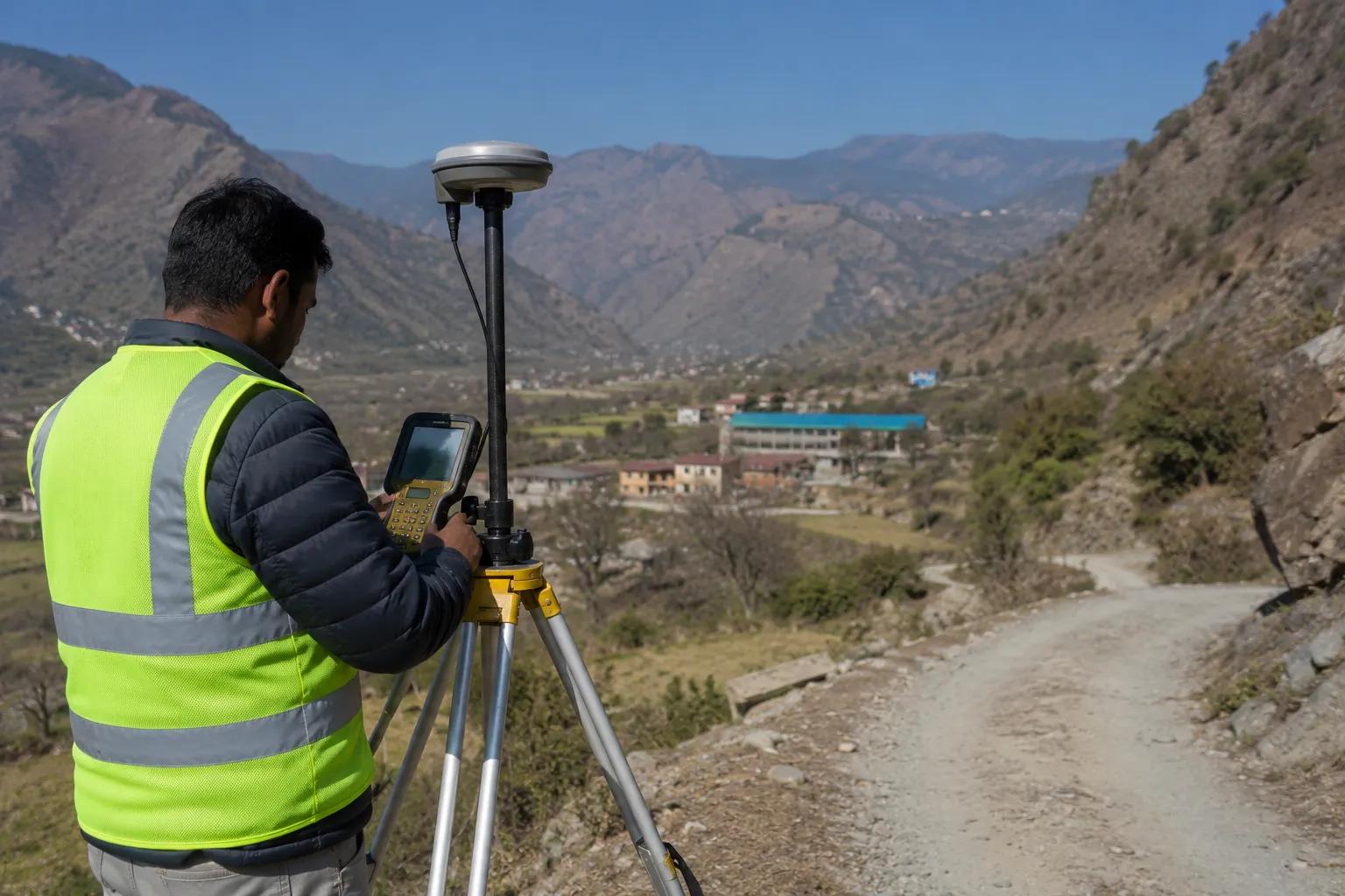
- Ground Validation: Field-based GPS verification and on-site terrain checks are critical for validating satellite data against actual ground conditions.
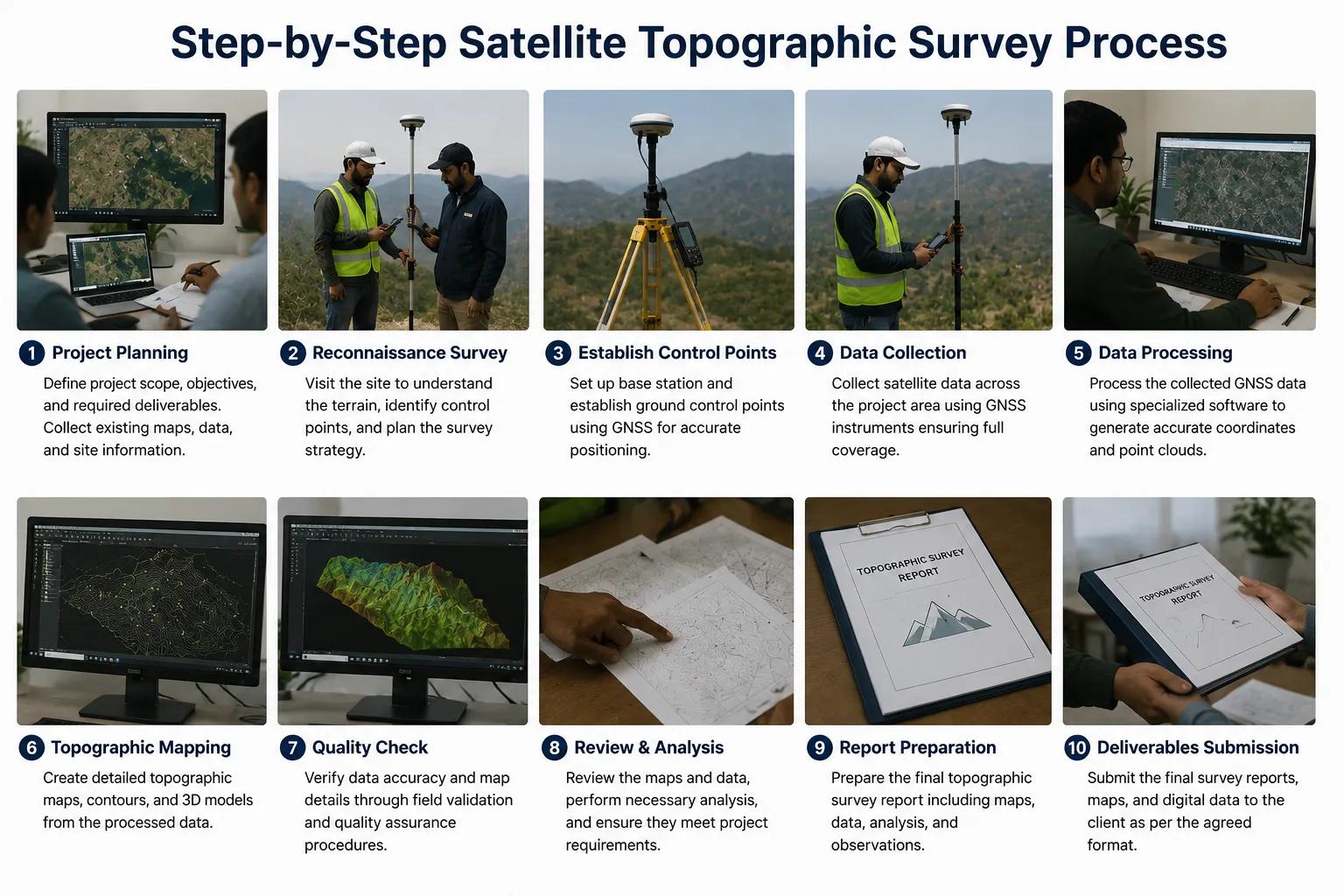
Step-by-Step Satellite Topographic Survey Process
Bhoojal Survey follows a rigorous, scientifically validated workflow for every satellite topographic survey engagement to ensure data accuracy, reliability, and engineering usability:
- Project Requirement Analysis — Define area of interest, accuracy requirements, and deliverableformats.
- Satellite Data Acquisition — Source appropriate satellite imagery (optical/SAR) for the project area.
- Remote Sensing Data Processing — Orthorectification, atmospheric correction, and data calibration.
- GIS Terrain Mapping — Spatial data integration, layer management, and coordinate system setup.
- Digital Elevation Modelling — DEM generation, slope analysis, and terrain classification.
- Terrain Feature Interpretation — Identification of landforms, drainage patterns, and critical terrainzones.
- Ground Validation Survey — Field teams verify satellite data against GPS-measured ground controlpoints.
- Geospatial Data Analysis — Advanced terrain analysis for engineering-specific project outputs.
- Mapping and Visualisation — Final contour maps, 3D terrain models, and GIS-ready datasets.
- Technical Report Preparation — Comprehensive geospatial survey report with engineeringrecommendations.
Benefits of Professional Satellite Topographic Survey Services
Benefit
Value Delivered
Accurate terrain and elevation mapping
Engineering-grade data for design and planning
Large-area coverage
Survey 100s of sq.km in days, not months
Faster project timelines
Quick data acquisition accelerates planning phases
Reduced survey costs
Lower overall project survey expenditure
GIS-integrated outputs
Directly usable in engineering design software
Scientific reporting
Reliable data for regulatory and statutory submissions
How Bhoojal Survey Can Help You
Bhoojal Survey is one of India's trusted names in geospatial survey services, with deep expertise spanning satellite topographic surveys, hydrogeological investigations, geophysical surveys, earthing analysis, and infrastructure testing. Here is how we add direct value to your project:
◆ End-to-End Survey Execution
From initial data acquisition to final technical report, our team manages the entire satellite topographic survey lifecycle — giving you accurate, ready-to-use terrain data without operational delays.
◆ Experienced Survey Engineers
Our team combines remote sensing expertise with deep field experience in India's diverse terrain — from Himalayan foothills to Deccan plateaus and coastal lowlands.
◆ Advanced Satellite Mapping Technology
We use high-resolution satellite imagery, GIS-integrated terrain analysis platforms, and validated DEM generation workflows to deliver engineering-grade geospatial data.
◆ Integrated Hydrogeological and Geophysical Services
For projects requiring groundwater assessment alongside terrain mapping, Bhoojal Survey offers integrated hydrogeological surveys, geophysical investigations (using SSRMPATS, GER DETECT, PQWT instruments), and borewell location services — all under one roof.
◆ Pan-India Survey Capability
We serve EPC contractors, infrastructure developers, mining companies, solar project developers, government agencies, and industrial clients across all states in India.
◆ Fast Turnaround and Professional Reporting
Bhoojal Survey delivers accurate terrain data and comprehensive geospatial reports within project timelines, with detailed technical documentation suitable for DPR submissions, regulatory approvals, and engineering design.
◆ Customised Geospatial Solutions
Every project has unique terrain mapping requirements. We provide customised satellite topographic survey solutions tailored to your specific project scale, accuracy needs, and reporting requirements.
◆ Competitive Survey Costs
Our streamlined geospatial workflows and advanced remote sensing capabilities enable us to deliver high-quality satellite topographic survey services at competitive pricing across India.
Why Choose Bhoojal Survey for Satellite Topographic Survey Services
- 15+ years of experience in geospatial and hydrogeological survey services
- Advanced satellite mapping and GIS terrain analysis capabilities
- Accurate, validated terrain and elevation data for engineering applications
- Professional data interpretation with actionable engineering insights
- Fast reporting, documentation, and GIS-ready dataset delivery
- Pan-India project execution capability — all terrains, all climatic zones
- Integrated groundwater, geophysical, and infrastructure testing services
- Trusted by EPC contractors, government agencies, and infrastructure developers
Conclusion
Satellite topographic surveys have redefined how India's infrastructure projects approach terrain intelligence. By combining satellite elevation mapping, remote sensing terrain analysis, GIS topographic data, and digital elevation modelling, modern survey consultancies can deliver engineering-grade terrain data faster, more accurately, and at lower cost than ever before.
Whether you are planning a highway corridor, a solar power plant, a mining operation, or an urban development project, reliable geospatial terrain analysis is the first step toward informed engineering decisions. Bhoojal Survey brings together satellite mapping technology, experienced survey engineers, and integrated geophysical services to support every phase of your project — from feasibility to execution.
Partner with Bhoojal Survey for professional satellite topographic survey services across India. Get accurate terrain data, faster project timelines, and engineering insights you can trust.
■ Contact Bhoojal Survey Today
For satellite topographic surveys, GIS terrain mapping, hydrogeological surveys, geophysical investigations, and infrastructure testing services across India
Frequently Asked Questions (FAQ)
Q: What is a satellite topographic survey?
A: A satellite topographic survey is a geospatial mapping process that uses earth observation satellites to capture high-resolution terrain data, which is processed to generate elevation maps, contour lines, digital elevation models (DEM), and terrain analysis outputs for engineering and infrastructure planning.
Q: How does satellite terrain mapping work?
A: Satellite terrain mapping works by acquiring land surface data using satellite-borne optical and SAR sensors. The raw imagery is processed using remote sensing and GIS tools to produce precise terrain maps, slope profiles, elevation models, and geospatial datasets ready for engineering use.
Q: What industries use satellite topographic surveys?
A: Key industries include highway and road development, solar power plant projects, mining and excavation, urban and smart city planning, airport and railway infrastructure, industrial development, environmental monitoring, and government infrastructure programmes across India.
Q: How accurate is satellite topographic mapping?
A: Modern satellite topographic surveys using high-resolution platforms (e.g., CARTOSAT, Sentinel) achieve horizontal accuracy of 1–5 metres and vertical elevation accuracy of 1–3 metres, further refined through GPS-based ground validation and advanced DEM processing.
Q: What is a Digital Elevation Model (DEM)?
A: A Digital Elevation Model (DEM) is a 3D representation of a terrain surface derived from satellite elevation data. It is used for slope analysis, volume calculations, drainage delineation, flood modelling, and engineering design — making it a core output of satellite topographic survey services.
Q: How long does a satellite topographic survey take?
A: For most infrastructure projects, satellite data acquisition can be completed in 2–5 days, with full GIS processing, DEM generation, and report delivery typically completed within 10–20 working days depending on project area and complexity.
Q: Can Bhoojal Survey conduct satellite topographic surveys across all Indian states?
A: Yes. Bhoojal Survey offers pan-India satellite topographic survey services, covering all geographic terrains — plains, plateaus, hills, coastal zones, and arid regions — for infrastructure, mining, solar, and government projects.
Q: Does Bhoojal Survey offer integrated groundwater and terrain survey services?
A: Yes. Bhoojal Survey uniquely combines satellite topographic surveys with hydrogeological investigations, geophysical surveys (using SSRMPATS, GER DETECT, PQWT), borewell location services, and earthing analysis — providing complete geospatial and subsurface intelligence for any project.