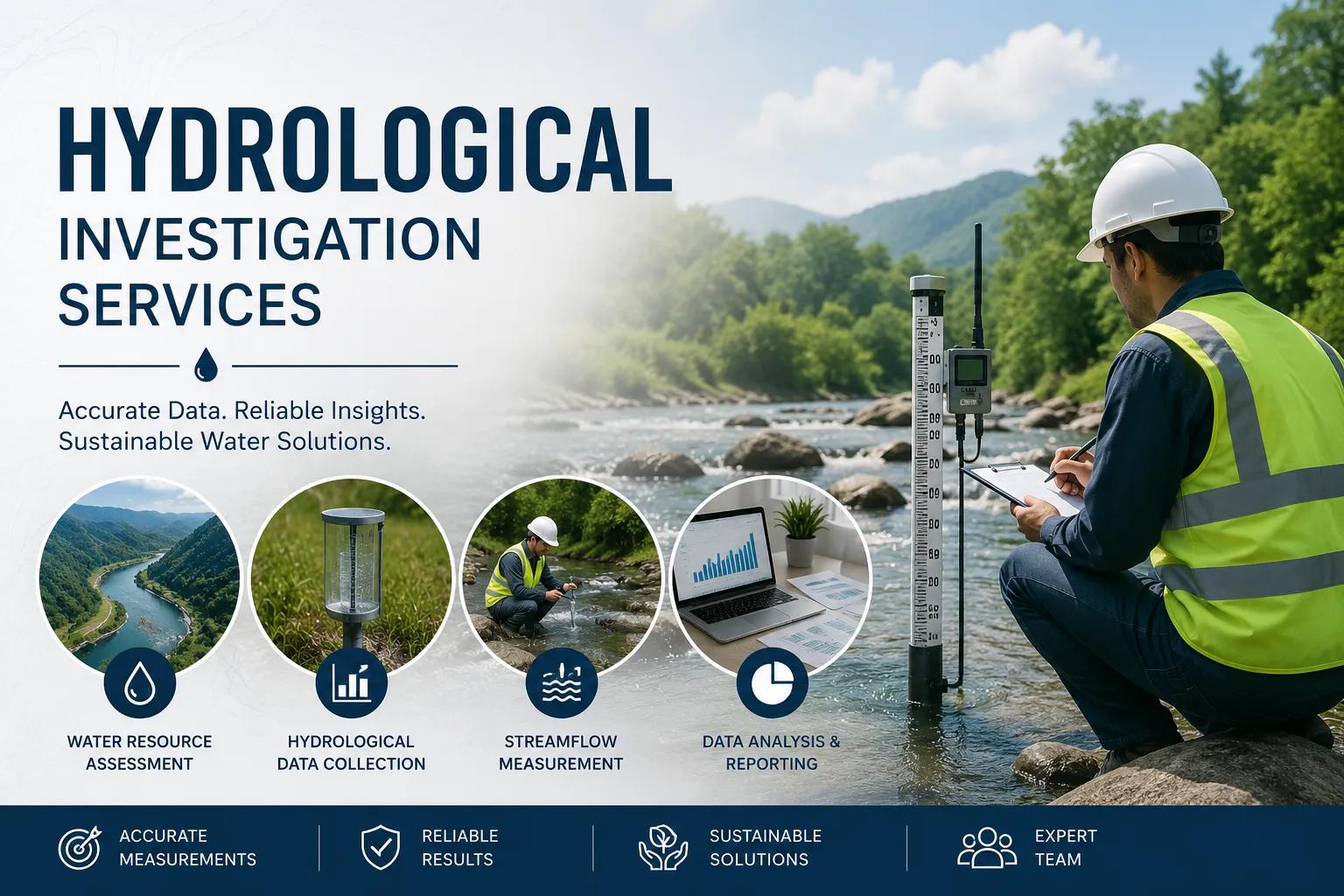
Water is the foundation of every successful infrastructure project — and understanding how it moves, accumulates, and interacts with the land beneath your feet is not optional; it is essential. Hydrological investigation is the systematic, science-driven process of studying the distribution, movement, and quality of water across surface and subsurface environments. From dam safety assessments to smart city water planning, from mining dewatering strategies to irrigation network design, every major project depends on accurate, data-backed hydrological insight.
Bhoojal Survey delivers end-to-end hydrological investigation services across India, combining field expertise, advanced instrumentation, and GIS-powered analysis to help government agencies, EPC contractors, industries, and infrastructure developers make confident, well-informed water resource decisions.
Quick Definition: Hydrological investigation is the scientific study of the hydrological cycle — encompassing rainfall analysis, surface water monitoring, groundwater assessment, watershed mapping, and hydrological modeling — to support sustainable water resource planning and infrastructure development.
What Is Hydrological Investigation?
Hydrological investigation is the comprehensive scientific process of evaluating water resources — both above and below ground. It examines how precipitation is absorbed by the soil, how rivers and streams carry surface water, how aquifers store and release groundwater, and how human activity alters the natural hydrological cycle.
A professional hydrological survey integrates field data collection, laboratory analysis, remote sensing, and numerical modeling to produce authoritative assessments used in planning irrigation systems, designing dams and bridges, evaluating flood risks, and managing groundwater recharge.
At its core, hydrological investigation answers three critical questions for any project:
- How much water is available — and where?
- How does water move through this landscape and subsurface geology?
- How will changing conditions affect future water availability?
Why Is Hydrological Investigation Important?
Skipping or underinvesting in hydrological assessment services is one of the most costly mistakes an infrastructure or industrial project can make. Poor water data leads to structural failures, cost overruns, regulatory violations, and environmental damage. Professional hydrological investigation provides the foundation for:
- Water Resource Management: Identify sustainable water sources and calculate reliable yield for drinking water, agriculture, and industrial supply.
- Flood Risk Assessment: Quantify flood frequency, peak discharge, and inundation extents to design safe drainage and protective infrastructure.
- Groundwater Recharge Planning: Map recharge zones and calculate aquifer storage capacity to support bore well development and rainwater harvesting.
- Infrastructure Safety: Assess seepage, waterlogging, and subsurface drainage conditions critical for roads, railways, bridges, and buildings.
- Sustainable Water Management: Support long-term groundwater management and comply with environmental clearance requirements under Indian regulations.
- Environmental Protection: Evaluate impacts on rivers, wetlands, and ecosystems as part of environmental impact assessment (EIA) studies.
Applications of Hydrological Investigation in India
Bhoojal Survey provides water resource investigation services across a wide spectrum of sectors. Our hydrological expertise directly supports:
- Dam & Reservoir Projects: Catchment area analysis, hydrological yield studies, spillway design flood calculations, and dam break simulation.
- Irrigation Planning: Canal command area assessment, crop water demand analysis, and groundwater-surface water conjunctive use planning.
- Urban Infrastructure Development: Stormwater drainage design, urban flood modeling, and smart city water supply planning.
- Mining & Industrial Projects: Mine dewatering studies, industrial effluent impact assessment, and groundwater baseline surveys for environmental compliance.
- Environmental Impact Assessment (EIA): Scientific water resource investigation for regulatory clearances under MoEF&CC guidelines.
- Railway & Highway Projects: Bridge hydraulic design, culvert sizing, slope stability under waterlogged conditions, and road drainage studies.
- Agricultural Water Management: Groundwater recharge analysis, micro-watershed planning, and drip/sprinkler feasibility hydrological studies.
- Flood Control Projects: River basin hydrological study, flood plain mapping, and retention pond design.
Methods Used in Hydrological Investigation
Surface Water Analysis
Surface water investigation begins with systematic monitoring of rivers, streams, ponds, and lakes. Bhoojal Survey's hydrology field investigation teams install flow meters, staff gauges, and automated water level loggers to capture real-time hydrological data. Rainfall-runoff relationships are established using historical rain gauge data, and watershed mapping identifies catchment boundaries, slope gradients, and drainage density that govern surface water flow.
Groundwater Investigation
Our groundwater hydrology study methodology involves systematic aquifer analysis through pumping tests, recovery tests, and slug tests to determine hydraulic conductivity and storage coefficients. Borewell feasibility analysis identifies productive aquifer zones using resistivity profiling. Groundwater recharge studies map natural recharge zones, quantify annual recharge, and recommend artificial recharge structures including check dams, percolation ponds, and injection wells.
Remote Sensing & GIS Hydrological Analysis
Modern hydrological monitoring survey relies heavily on satellite-based remote sensing and geographic information systems. Our team processes multi-temporal satellite imagery (Landsat, Sentinel, LISS-IV) to map land use, surface water extent, and vegetation cover. GIS-based watershed mapping delineates sub-watersheds, stream networks, and flood plains with high spatial precision. Hydrological modeling using SWAT, HEC-HMS, and HEC-RAS frameworks enables simulation of flood events, water balance components, and climate change impacts.
Equipment and Instruments Used in Hydrological Surveys
Reliable scientific water resource investigation demands precision instruments and proven technology.
Bhoojal Survey deploys the following equipment on all hydrological investigation assignments:
- Rain gauges and automatic weather stations for continuous rainfall monitoring
- Electromagnetic and ultrasonic flow meters for river and canal discharge measurement
- Automated water level loggers and pressure transducers for groundwater monitoring
- Piezometers and standpipe wells for accurate aquifer head measurement
- GPS and total station survey equipment for precise site mapping
- Drone-based photogrammetry for watershed topographic mapping
- GIS and remote sensing software (ArcGIS, QGIS, Google Earth Engine)
- Hydrological modeling platforms: HEC-HMS, HEC-RAS, SWAT, MODFLOW
For groundwater potential zone identification, our teams conduct hydrogeological surveys using SSRMPATS Instrument, GER DETECT, and PQWT at site for open well and borewell location — ensuring scientifically selected drilling points that maximize groundwater yield and reduce project risk.
Factors Affecting Hydrological Conditions
Every hydrological data analysis must account for the complex interplay of physical, geological, and climatic factors that control how water behaves in a specific region. Key factors include:
- Rainfall Patterns: Intensity, duration, and seasonal distribution of precipitation directly control surface runoff generation and groundwater recharge rates.
- Soil Permeability: Infiltration capacity governs the proportion of rainfall that becomes groundwater recharge versus surface runoff.
- Geological Formations: Bedrock type, fracture density, and aquifer lithology determine groundwater storage and transmissivity.
- Land Use Changes: Urbanization, deforestation, and agricultural intensification alter evapotranspiration and runoff characteristics significantly.
- Climate Conditions: Temperature trends, evaporation rates, and climate variability affect long-term water availability forecasts.
- Groundwater Recharge Rates: Natural and artificial recharge balance determines aquifer sustainability and borewell yield over time.
- Surface Runoff Characteristics: Watershed slope, channel geometry, and land cover control flood peak timing and magnitude.
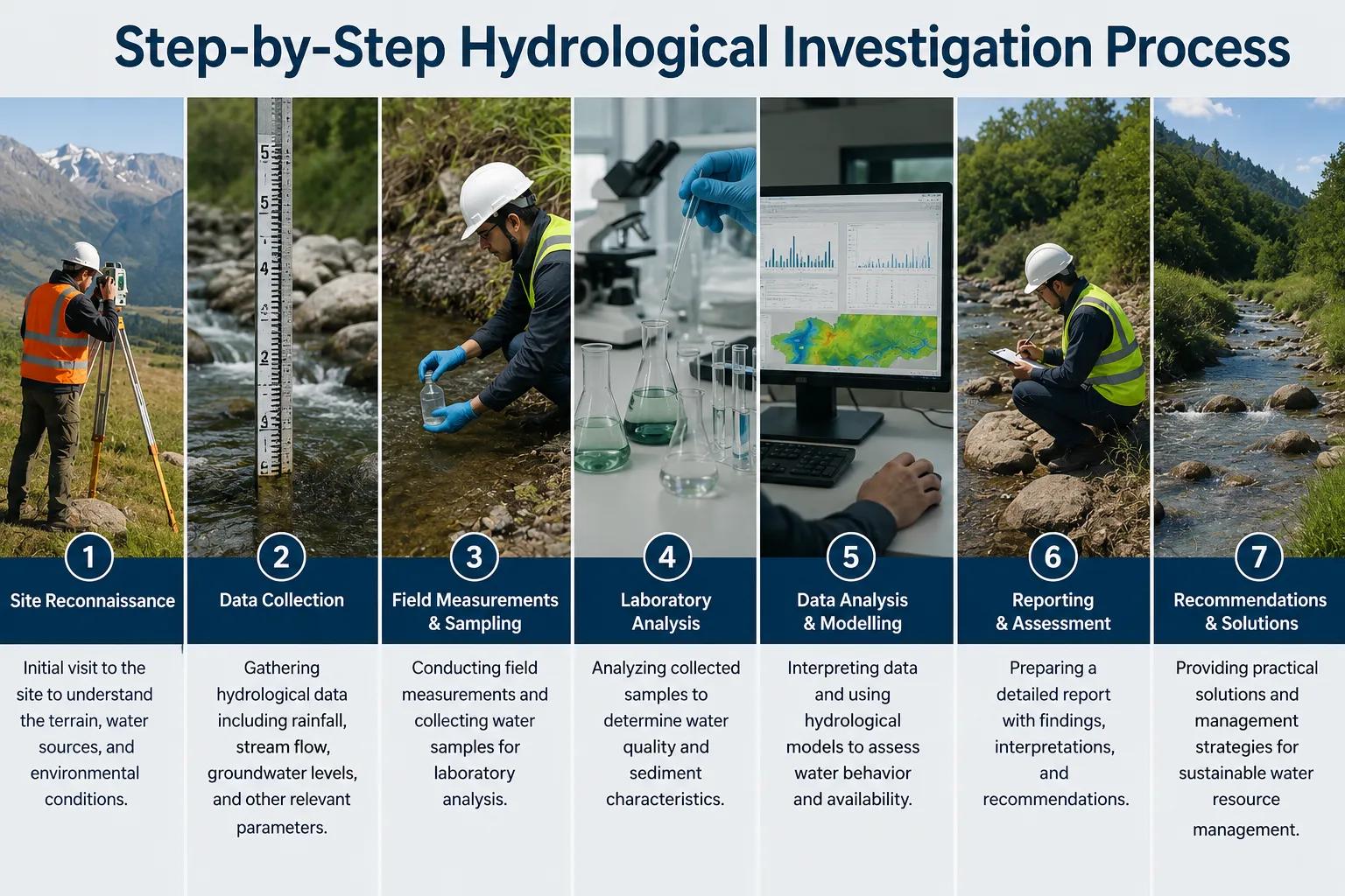
Step-by-Step Hydrological Investigation Process
Bhoojal Survey follows a structured, technically rigorous workflow for every hydrology consulting services engagement:
- Step 1 – Site Reconnaissance: Preliminary field visit to understand topography, drainage patterns, vegetation, and existing water structures.
- Step 2 – Hydrological Survey Planning: Design field investigation plan including monitoring network layout, sampling strategy, and instrument deployment schedule.
- Step 3 – Rainfall & Watershed Data Analysis: Compile historical rainfall records, calculate design storms, and delineate watershed boundaries using DEM analysis.
- Step 4 – Surface Water Monitoring: Install flow measurement stations and collect discharge data across all watercourses within the project influence zone.
- Step 5 – Groundwater Investigation: Conduct aquifer testing, water table measurement, and geophysical surveys for subsurface characterization.
- Step 6 – GIS & Remote Sensing Analysis: Process satellite imagery, map land use change, identify recharge zones, and build GIS layers for hydrological modeling.
- Step 7 – Field Measurements & Sampling: Collect water quality samples, soil infiltration tests, and geotechnical data for integrated analysis.
- Step 8 – Hydrological Data Interpretation: Apply statistical analysis, frequency analysis, and trend evaluation on collected datasets.
- Step 9 – Hydrological Modeling Study: Develop and calibrate rainfall-runoff and groundwater flow models to simulate current and future conditions.
- Step 10 – Technical Reporting: Produce comprehensive hydrological investigation report with data tables, maps, model outputs, and actionable engineering recommendations.
Benefits of Professional Hydrological Investigation Services
- Accurate, defensible water resource data for project planning and regulatory submissions
- Reduced risk of flood damage, waterlogging, and groundwater depletion
- Optimized infrastructure design leading to significant capital cost savings
- Sustainable groundwater management ensuring long-term water security
- Faster environmental clearance with scientifically credible hydrological reports
- Improved operational efficiency for mining, irrigation, and industrial projects
How Bhoojal Survey Can Help You
Whether you are planning a dam, developing a mine, designing a smart city drainage network, or seeking groundwater for an industrial facility, Bhoojal Survey is your trusted professional hydrology investigation company. Here is exactly how we add value:
- Customized Hydrological Investigation Plans: We design every investigation to match your project's specific scale, geology, budget, and regulatory requirements — no generic templates.
- End-to-End Field Investigation: From initial site reconnaissance to final report delivery, our experienced hydrologists and hydrogeologists manage every stage of field data collection and analysis, ensuring accuracy and completeness.
- Advanced Groundwater Survey with Proven Instruments: Our teams use SSRMPATS, GER
DETECT, and PQWT instruments for precise subsurface investigation, dramatically increasing borewell success rates and reducing unnecessary drilling costs.
- GIS & Remote Sensing Expertise: We deliver high-resolution watershed maps, flood zone delineations, and groundwater potential maps using the latest satellite data and GIS platforms — giving your project team clear, actionable spatial intelligence.
- Hydrological Modeling for Infrastructure Design: Our engineers develop and calibrate HEC-HMS, HEC-RAS, SWAT, and MODFLOW models to support flood design, dam safety, drainage engineering, and groundwater resource estimation.
- Regulatory Compliance Support: We prepare hydrological sections for Environmental Impact Assessment (EIA) reports, groundwater clearance applications (CGWA), and state water authority submissions — helping you meet compliance deadlines without delays.
- Fast Turnaround & Detailed Reporting: We understand project timelines. Bhoojal Survey delivers clear, well-structured hydrological investigation reports with maps, data tables, model outputs, and professional engineering recommendations on schedule.
- Pan-India Service Coverage: From the Himalayan foothills to the Deccan plateau, from arid Rajasthan to the river basins of Assam, our hydrological investigation teams are equipped to operate in any hydrogeological environment across India.
- Hydrology for Every Sector: Government water departments, private EPC contractors, mining companies, irrigation project developers, smart city authorities, and industrial planners — Bhoojal Survey has the domain expertise to support every sector with scientific, reliable water resource investigation.
Why Choose Bhoojal Survey for Hydrological Investigation?
Bhoojal Survey is a leading groundwater hydrological investigation company with deep expertise in water resource investigation across diverse Indian geological and climatic conditions. Our competitive advantage:
- Experienced, field-proven hydrology and hydrogeology professionals
- Advanced hydrological survey instruments including SSRMPATS, GER DETECT, and PQWT
- Integrated GIS and remote sensing capabilities for watershed and aquifer mapping
- Hydrological modeling expertise covering HEC-HMS, HEC-RAS, SWAT, and MODFLOW
- Fast reporting with clear, actionable recommendations for engineering teams
- Pan-India project experience across all major hydrogeological environments
- Customized water investigation solutions aligned with project type and budget
- Strong track record with government agencies, EPC firms, and industrial clients
- Scientific methodology ensuring data accuracy, reproducibility, and regulatory acceptance
Conclusion
Hydrological investigation is not simply a preliminary study — it is the scientific backbone of every responsible water resource, infrastructure, and environmental project. Inadequate investigation leads to design failures, regulatory rejections, and long-term environmental liability. Accurate, professional hydrological assessment leads to better decisions, safer infrastructure, and sustainable water futures.
Bhoojal Survey brings together experienced field professionals, advanced instrumentation, GIS and remote sensing capabilities, and rigorous scientific methodology to deliver hydrological investigation reports that engineering teams, project planners, and regulatory authorities can rely on.
Ready to Start Your Hydrological Investigation? Contact Bhoojal Survey Today —
Pan-India Hydrology Consultancy Services www.bhoojal.in | [email protected]
Frequently Asked Questions (FAQ)
Q: What is hydrological investigation?
A: Hydrological investigation is the systematic scientific study of the distribution, movement, and quality of water in surface and subsurface environments. It includes rainfall analysis, watershed mapping, river flow monitoring, groundwater assessment, and hydrological modeling to support water resource planning and infrastructure design.
Q: Why is hydrological investigation important for infrastructure projects?
A: Infrastructure projects such as dams, bridges, roads, and urban developments must account for water-related risks including flooding, waterlogging, and groundwater interference. Hydrological investigation provides the technical data needed to design safe, cost-effective, and regulatory-compliant infrastructure.
Q: What methods are used in a hydrological survey?
A: A hydrological survey typically includes surface water flow monitoring, rainfall data analysis, aquifer testing, geophysical surveys, remote sensing, GIS-based watershed mapping, and hydrological modeling using tools such as HEC-HMS, HEC-RAS, SWAT, and MODFLOW.
Q: How long does a hydrological investigation take?
A: Duration varies with project scope and complexity. A standard hydrological investigation for a medium-scale infrastructure project typically takes between 3 to 8 weeks, covering field data collection, laboratory analysis, GIS mapping, modeling, and report preparation.
Q: Which industries require hydrological investigation services?
A: Hydrological investigation is required across a wide range of sectors including dam and reservoir engineering, irrigation development, mining, road and railway construction, urban planning, environmental impact assessment, agricultural water management, and industrial water supply planning.
Q: How does GIS remote sensing support hydrological investigation?
A: GIS and remote sensing enable large-scale watershed delineation, land use change detection, flood plain mapping, and groundwater potential zone identification using satellite imagery. These tools significantly improve spatial accuracy and reduce field investigation costs.
Q: Can Bhoojal Survey provide hydrological investigation across all Indian states?
A: Yes. Bhoojal Survey operates pan-India, with field teams and technical resources experienced in the diverse hydrogeological and climatic conditions of all major Indian regions — from alluvial plains to hard rock terrains, from arid zones to high-rainfall catchments.
Q: What is included in a Bhoojal Survey hydrological investigation report?
A: Our comprehensive reports include project background and site description, hydrological data tables, watershed and aquifer maps, model simulation results, flood frequency analysis, groundwater recharge