

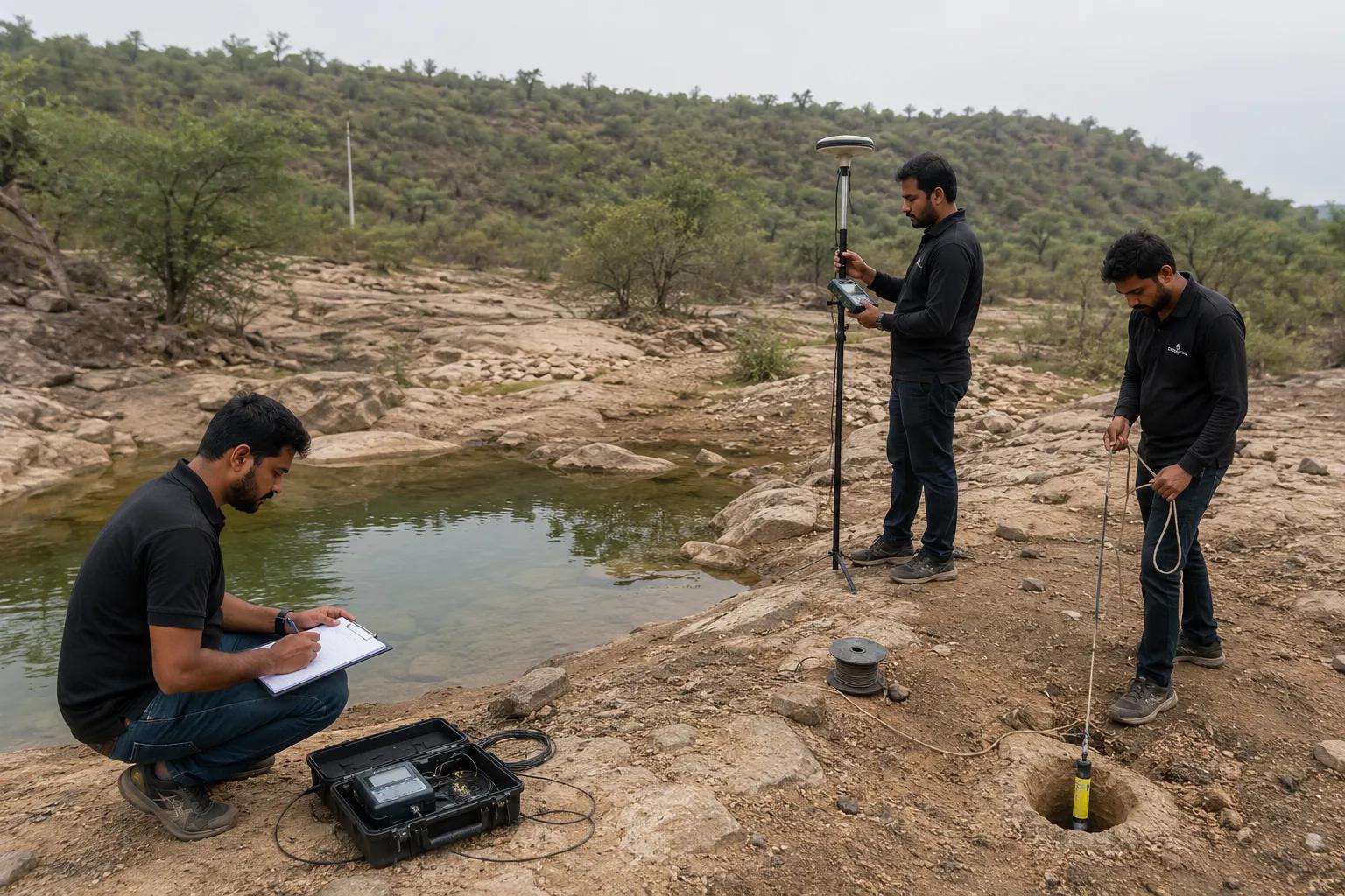
Hydrogeological Survey: Scientific Groundwater Exploration for Every Project
Introduction
A hydrogeological survey is a scientific investigation that studies subsurface geology, aquifer characteristics, and groundwater potential before drilling or resource development. It combines geological mapping, geophysical testing, and technical analysis to determine where and how deep groundwater can be accessed reliably.
For industrial developers, farmers, mining companies, and infrastructure projects, a hydrogeological survey is essential before any groundwater extraction begins. It reduces the risk of dry borewells, supports sustainable water resource management, and forms a critical part of regulatory and CGWA compliance.
A scientifically conducted hydrogeological assessment improves drilling accuracy, lowers project costs, and ensures long-term groundwater sustainability across agricultural, industrial, and infrastructure sectors in India.
What is Hydrogeological Survey?
A hydrogeological survey is a technical study that assesses subsurface rock formations, aquifer layers, and groundwater flow to determine the best locations for water extraction. Its key objectives include:
1. Identifying aquifer depth, type, and thickness
2. Assessing groundwater potential and yield
3. Determining water quality and recharge patterns
4. Reducing risks of borewell failure
5. Supporting sustainable groundwater management and CGWA compliance
This groundwater investigation provides the scientific foundation needed for borewell drilling, industrial water planning, and irrigation projects.
Methods Used in Hydrogeological Survey
A professional hydrogeological survey relies on a mix of geological and geophysical techniques:
1. Geological mapping – analyzing rock formations and terrain structure
2. Electrical resistivity survey – detecting water-bearing subsurface layers
3. Geophysical investigation – studying subsurface properties in detail
4. GIS and satellite imagery – mapping groundwater potential zones
5. Aquifer characterization – identifying depth, thickness, and quality
6. Groundwater potential assessment – evaluating sustainable yield
At Bhoojal Survey, our experts specialize in conducting hydrogeological survey using SSRMPATS Instrument, GER DETECT, and PQWT at site for open well / borewell location.
This scientific groundwater investigation and analysis, supported by advanced groundwater and geophysical survey solutions, ensures reliable and technically sound results for every project.
Benefits and Applications of Hydrogeological Survey
A well-executed hydrogeological survey delivers strong practical value:
1. Accurate borewell location based on verified subsurface data
2. Higher drilling success rate, minimizing dry or low-yield wells
3. Sustainable groundwater management for long-term water security
4. Reduced drilling costs through precise targeting
5. Industrial water planning for manufacturing and processing units
6. Irrigation development for agricultural businesses
7. Infrastructure and mining project support
8. Environmental compliance aligned with CGWA norms
These benefits apply across industrial, agricultural, mining, and infrastructure sectors, making hydrogeological surveys a valuable investment rather than an optional step.
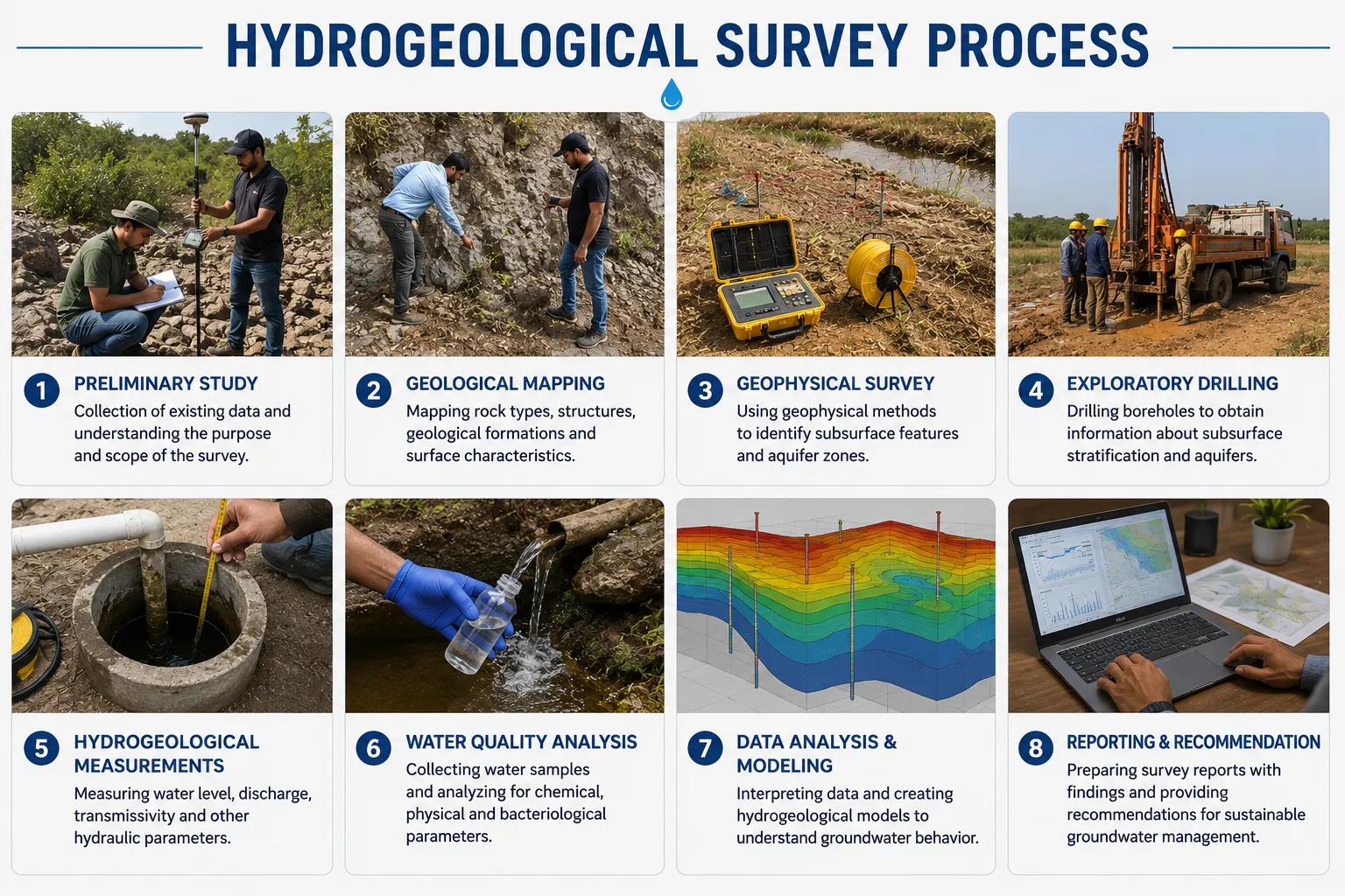
Hydrogeological Survey Process
Bhoojal Survey follows a structured, step-by-step process:
- Site inspection – understanding project terrain and requirements
- Geological assessment – studying rock and soil formations
- Geophysical data collection – using resistivity and detection instruments
- Groundwater analysis – interpreting aquifer depth and yield potential
- Technical interpretation – translating data into actionable insights
- Survey report preparation – documenting findings for approvals
- Recommendations – guiding borewell drilling or groundwater development decisions
This systematic approach ensures every hydrogeological survey delivers accurate, actionable results.
Why Choose Bhoojal Survey
Bhoojal Survey combines technical expertise with reliable service delivery:
1. Experienced hydrogeologists and geophysicists with proven field expertise
2. Latest groundwater survey technologies for precise results
3. Accurate borewell location identification backed by scientific data
4. Professional technical reports suited for approvals and planning
5. Fast project execution across diverse site conditions
6. Pan-India consultancy services covering varied geological terrains
7. Expertise in groundwater exploration and CGWA compliance
7. Customized solutions tailored to industrial, agricultural, and infrastructure needs
Conclusion
A hydrogeological survey is essential before any groundwater development project, helping identify reliable water sources while reducing costs, risks, and drilling failures. Scientific groundwater investigations give industrial developers, farmers, and infrastructure companies the confidence to plan projects sustainably and in compliance with regulatory standards.
Bhoojal Survey's experienced team delivers accurate, technology-driven hydrogeological survey services across India. Contact Bhoojal Survey today for a professional hydrogeological consultation and secure your groundwater resources with proven scientific expertise.
FAQs
1. What is a hydrogeological survey?
A hydrogeological survey is a scientific study of subsurface geology and aquifers used to determine groundwater potential before drilling.
2. Why is a hydrogeological survey required before drilling a borewell?
It helps identify accurate borewell locations, reducing the risk of dry wells and lowering overall drilling costs.
3. Which equipment is used in a hydrogeological survey?
Common instruments include SSRMPATS, GER DETECT, and PQWT, along with resistivity meters and GIS-based mapping tools.
4. How long does a hydrogeological survey take?
Most hydrogeological surveys are completed within one to two days, depending on site size and geological complexity.
5. How accurate is a hydrogeological survey?
When conducted by experienced hydrogeologists using advanced instruments, hydrogeological surveys offer high accuracy in locating viable groundwater sources.