Drilling a borewell without a proper scientific investigation is one of the most common and costly mistakes made by farmers, developers, and project owners across India. A failed borewell means wasted investment, delayed projects, and no water. The solution is simple — conduct a professional hydrogeological survey to locate groundwater for borewell before any drilling begins.
At Bhoojal Survey, we specialise in scientific groundwater investigations that identify the most productive aquifer zones, enabling accurate borewell site selection for agricultural, industrial, residential, and infrastructure projects across India.
What is a Hydrogeological Survey to Locate Groundwater for Borewell?
A hydrogeological survey to locate groundwater for borewell is a systematic scientific investigation of subsurface geological formations to identify water-bearing zones suitable for borewell or open well construction. It combines geology, geophysics, and hydrology to assess where groundwater exists, at what depth, and in what quantity.
The primary objectives of such a survey are to:
- Identify productive aquifer zones before drilling
- Determine the most suitable borewell location on a given site
- Estimate probable groundwater depth and expected yield
- Reduce the risk of dry borewells and failed drilling attempts
- Provide scientific data for sustainable groundwater development
Rather than relying on traditional water-divining methods or guesswork, a hydrogeological survey uses calibrated instruments and proven field techniques to deliver reliable, data-backed results.
Methods Used to Locate Groundwater for Borewell
Expert hydrogeologists use a combination of field investigation methods to accurately locate groundwater for borewell projects:
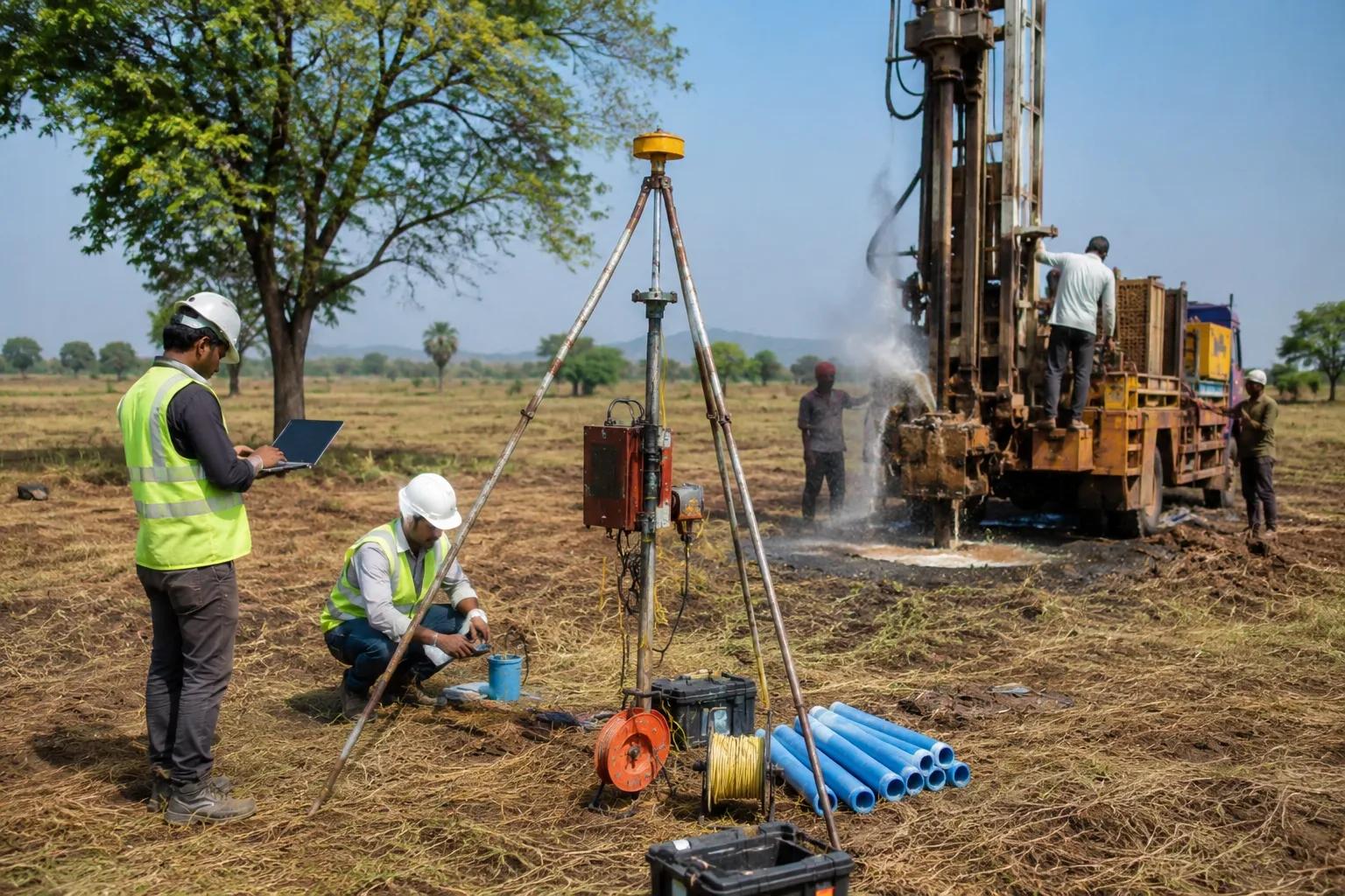
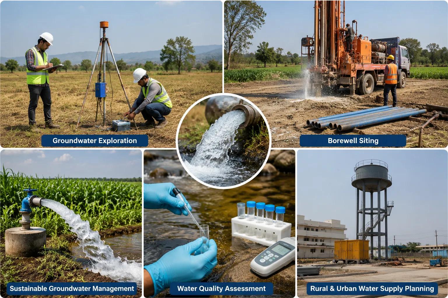
Hydrogeological Mapping — Trained geologists study the surface terrain, rock formations, soil types, drainage patterns, and lineament structures to identify areas with high groundwater occurrence probability.
Electrical Resistivity Surveys — This is the most widely used geophysical method for groundwater detection. Instruments measure the electrical resistance of subsurface layers, distinguishing water-saturated formations from dry rock or impermeable strata with high precision.
Geological Investigations — Analysing local rock types, fracture zones, fault lines, and lithological sequences helps determine aquifer characteristics, groundwater flow pathways, and recharge conditions.
Satellite and GIS Analysis — Remote sensing imagery and geographic information system mapping identify geological lineaments, recharge zones, and drainage basins across large project areas, supporting field-level groundwater assessment.
Aquifer Characterisation and Groundwater Potential Assessment — Combining all field data, hydrogeologists prepare a groundwater potential map identifying the best borewell locations, estimated depths, and probable yield ranges for the surveyed site.
Benefits of Hydrogeological Surveys for Borewell Projects
Investing in a scientific hydrogeological survey to locate groundwater for borewell before drilling delivers measurable advantages:
Higher Borewell Success Rates — Scientifically selected borewell sites have significantly higher success rates compared to sites chosen without a proper groundwater survey.
Reduced Drilling Costs — Accurate site selection avoids unnecessary drilling attempts in low-yield or dry zones, directly reducing overall project costs.
Better Groundwater Yield Estimation — Survey data provides a reliable estimate of expected water yield, helping clients plan their water supply systems accurately.
Accurate Site Selection — Multiple potential borewell locations are evaluated and ranked, giving clients the best available option on their land or project site.
Sustainable Groundwater Utilisation — Understanding aquifer capacity helps ensure that extraction rates remain within sustainable limits, protecting long-term groundwater availability.
At Bhoojal Survey, our field teams specialise in conducting hydrogeological survey using SSRMPATS Instrument, GER DETECT, and PQWT at site for open well / borewell location. These advanced instruments provide precise subsurface data that supports confident borewell site decisions. Our advanced groundwater and geophysical survey solutions, combined with scientific groundwater investigation and analysis, ensure that every client receives accurate, trustworthy results.
Applications of Hydrogeological Surveys in Groundwater Development
A professional hydrogeological survey for borewell location serves a wide range of sectors:
Agricultural Irrigation Systems — Farmers across India depend on borewells for crop irrigation. A scientific groundwater survey ensures reliable water access throughout the growing season.
Industrial Water Supply Projects — Manufacturing facilities, processing plants, and industrial parks require dependable groundwater sources. Hydrogeological surveys provide the data needed for industrial water supply planning.
Residential Developments — Housing colonies, townships, and apartment complexes in areas without municipal water supply rely on borewells. A survey ensures adequate water availability before construction begins.
Infrastructure Projects — Roads, highways, bridges, and construction sites require groundwater assessments for dewatering planning, dust suppression, and worker water supply needs.
Mining Operations — Mining companies require detailed groundwater investigations to manage inflow risks, plan drainage systems, and comply with environmental regulations.
Government Water Supply Schemes — Rural water supply programmes, irrigation projects, and government infrastructure developments across India depend on accurate hydrogeological surveys for effective planning and execution.
Why Choose Bhoojal Survey?
Bhoojal Survey is a leading groundwater exploration consultancy in India, trusted by farmers, industrialists, developers, and government agencies for reliable borewell location surveys and hydrogeological investigations.
We offer:
- Experienced hydrogeologists and geophysicists with deep field expertise across alluvial plains, hard rock terrains, and coastal groundwater zones
- Advanced groundwater survey instruments including SSRMPATS, GER DETECT, and PQWT for accurate subsurface profiling
- Accurate borewell location identification that consistently delivers higher drilling success rates for our clients
- Professional technical reporting with clear aquifer data, depth recommendations, and yield estimates
- Pan-India survey services covering diverse geological conditions from Rajasthan to Tamil Nadu and Gujarat to the Northeast
- Customised groundwater exploration solutions designed around each client's specific project requirements and budget
Our scientific approach eliminates the uncertainty from borewell drilling and replaces it with data-driven confidence.
Conclusion
A professional hydrogeological survey to locate groundwater for borewell is the most reliable way to ensure borewell drilling success. By combining geophysical surveys, geological mapping, and aquifer analysis, experienced hydrogeologists can accurately identify productive groundwater zones — saving clients from costly failures and ensuring long-term water security.
Bhoojal Survey delivers the scientific expertise, advanced instruments, and professional reporting needed for successful borewell site investigations across India.
Contact Bhoojal Survey today to schedule a hydrogeological groundwater survey for your borewell project. Our team is ready to provide accurate, reliable, and scientifically backed groundwater investigation solutions wherever you need them.
Frequently Asked Questions (FAQs)
Q1. What is a hydrogeological survey for borewell location? A hydrogeological survey for borewell location is a scientific investigation that uses geophysical instruments, geological mapping, and aquifer analysis to identify the most productive groundwater zones on a site. It helps determine the optimal borewell location, estimated depth, and probable water yield before drilling begins.
Q2. Why is a hydrogeological survey important before drilling a borewell? Without a proper hydrogeological survey, borewell drilling is based on guesswork and carries a high risk of failure. A scientific survey dramatically improves borewell success rates, reduces unnecessary drilling costs, and ensures that the chosen site has adequate groundwater availability for the intended purpose.
Q3. Which methods are used to locate groundwater for borewell surveys? Common methods include electrical resistivity surveys, hydrogeological field mapping, geological formation analysis, GIS and satellite lineament studies, and aquifer characterisation. Advanced instruments such as SSRMPATS, GER DETECT, and PQWT are used by Bhoojal Survey to deliver precise, field-verified groundwater detection results.
Q4. How accurate are hydrogeological groundwater surveys for borewells? When conducted by qualified hydrogeologists using calibrated geophysical instruments, hydrogeological surveys provide high accuracy in identifying productive borewell locations. Accuracy improves further when multiple survey methods are combined and interpreted by experienced professionals with knowledge of local geological conditions.
Q5. How long does a borewell groundwater survey take? A standard hydrogeological survey for borewell location on a typical agricultural or residential site can usually be completed within one to two days of field investigation. Larger sites, complex geological terrains, or projects requiring detailed aquifer characterisation reports may require additional survey time and analysis.