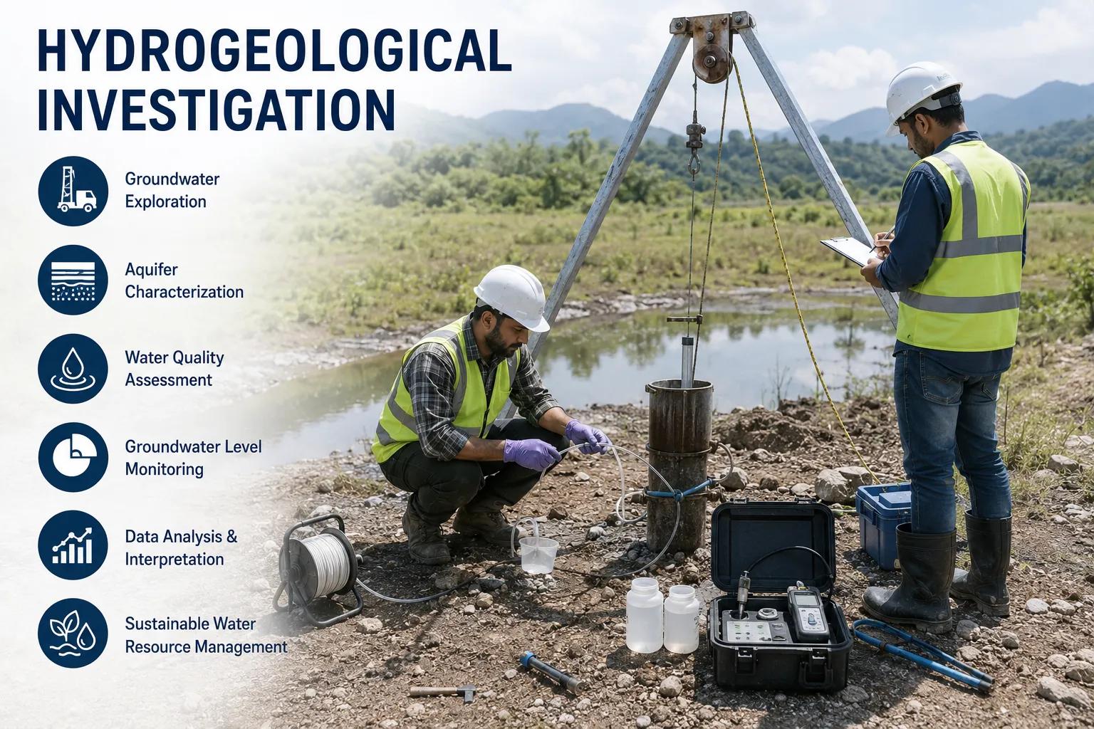
Water is the foundation of life, and understanding where it lies beneath the Earth's surface is a science that demands precision, expertise, and advanced technology. Hydrogeological investigation is the systematic study of subsurface groundwater — how it moves, where it accumulates, and how it can be responsibly accessed and managed.
For infrastructure developers, borewell contractors, EPC project planners, mining companies, irrigation departments, and government water resource agencies across India, a professional hydrogeological investigation is not optional — it is the foundation of every successful groundwater project. Without it, drilling becomes guesswork. With it, every decision is backed by data, science, and field-verified analysis.
At Bhoojal Survey, we deliver end-to-end hydrogeological investigation services across India, combining decades of field experience with advanced geophysical survey instruments and scientific data interpretation to ensure accurate borewell site selection, reliable aquifer identification, and sustainable groundwater resource planning.
What is Hydrogeological Investigation?
Hydrogeological investigation is a scientific, multi-disciplinary process of studying the occurrence, distribution, movement, and quality of groundwater within geological formations. It integrates principles of geology, hydrology, geophysics, and environmental science to build a comprehensive understanding of subsurface water systems.
At its core, a hydrogeological investigation answers three critical questions: Is groundwater present at this site? At what depth and in what quantity? Can it be sustainably extracted? These answers determine whether a borewell project succeeds or fails.
A complete hydrogeological site investigation involves surface geological mapping, geophysical surveys, remote sensing analysis, aquifer identification, groundwater potential zoning, and technical report preparation — all designed to guide drilling decisions with scientific precision.
Why Hydrogeological Investigation is Important
Across India, millions of rupees are spent annually on borewell drilling — a significant portion of which results in dry or low-yield wells due to the absence of prior hydrogeological investigation. A scientific groundwater investigation eliminates this risk.
- Accurate Borewell Site Selection: Identifies the most productive drilling locations based on aquifer depth, yield potential, and rock formation analysis.
- Sustainable Groundwater Management: Assesses recharge potential and extraction limits to prevent over-exploitation of aquifers.
- Risk Reduction in Drilling Projects: Reduces dry hole probability, saving significant costs in drilling, casing, and mobilisation.
- Infrastructure Planning Support: Provides critical water availability data for industrial, residential, and irrigation projects.
- Environmental Protection: Identifies contamination zones, protects sensitive aquifers, and supports environmental impact assessment (EIA) compliance.
Applications of Hydrogeological Investigation
The scope of hydrogeological investigation spans virtually every sector that depends on groundwater resources. Below are the most significant application areas:
Borewell Location Investigation
Determining the exact location, depth, and casing design for borewell drilling in residential, agricultural, and industrial settings.
Irrigation & Agriculture Projects
Assessing groundwater availability and sustainable yield for irrigation planning in farming communities and agri-projects.
Industrial Water Supply Planning
Supporting industrial parks, factories, and processing units with reliable groundwater source identification.
Evaluating groundwater inflow risks in mine planning and dewatering strategies for open-cast and underground operations.
Infrastructure & Construction
Providing groundwater depth data for foundation design, dewatering plans, and civil construction risk management.
Urban Groundwater Management
Mapping aquifer systems beneath urban areas for municipal water planning and sustainable city development.
Environmental Impact Assessment
Supplying baseline hydrogeological data required for regulatory EIA submissions and green project approvals.
Water Resource Development
Identifying and characterising aquifers for regional water supply schemes, watershed management, and drought mitigation.
Methods Used in Hydrogeological Investigation
1. Geological Survey
A thorough geological survey forms the backbone of any groundwater exploration exercise. Field geologists study the surface rock formations, soil types, structural lineaments, fault zones, and fracture patterns — all of which directly influence groundwater storage and movement. Geological mapping helps identify zones of high aquifer potential before any drilling commences.
2. Geophysical Survey
Geophysical survey methods are the most powerful tools in groundwater detection. Electrical Resistivity Tomography (ERT), Vertical Electrical Sounding (VES), and electromagnetic surveys allow investigators to profile the subsurface without a single metre of drilling. These techniques distinguish between water-bearing formations and dry, compact rock — providing reliable aquifer identification data with high spatial resolution.
3. Remote Sensing and GIS Analysis
Satellite imagery, aerial photography, and digital elevation models reveal large-scale hydrogeological patterns invisible from the ground. GIS-based analysis integrates drainage networks, land use, soil maps, lineament patterns, and recharge zones into a comprehensive hydrogeological map — guiding field surveys to the most promising target areas.
Equipment and Technologies Used in Hydrogeological Investigation
At Bhoojal Survey, we deploy industry-leading instruments and proven survey technologies to ensure the most accurate groundwater detection outcomes:
Resistivity Meters
For VES and ERT surveys to map subsurface resistivity and identify aquifer zones.
SSRMPATS Instrument
Advanced multi-parameter system for precise groundwater prospecting.
GER DETECT
Specialised groundwater detection technology for rapid site assessment.
PQWT Equipment
High-sensitivity instrument suite for open well and borewell location surveys.
GPS Mapping Tools
High-accuracy GPS receivers for precise survey station positioning and site documentation.
GIS Mapping SoftwareHydrogeological Data
Analysis Systems
Integrated software for data processing, cross-section generation, and aquifer modelling.
Field Note: Bhoojal Survey conducts hydrogeological surveys using the SSRMPATS Instrument, GER DETECT, and PQWT at site for open well and borewell location investigation — delivering advanced groundwater and geophysical survey solutions with scientific groundwater investigation and analysis methodologies.
Factors Affecting Groundwater Availability
Understanding what controls groundwater availability is fundamental to any hydrogeological investigation. The following factors are systematically evaluated during every Bhoojal Survey site assessment:
- Geological Formations: Rock type, porosity, and fracture density determine aquifer capacity and yield.
- Soil & Rock Permeability: Controls how quickly water infiltrates and recharges the aquifer system.
- Rainfall Patterns: Annual precipitation, intensity, and seasonal distribution directly influence recharge rates.
- Groundwater Recharge Zones: Identification of natural recharge areas is critical for long-term sustainability planning.
- Land Use Changes: Urbanisation, deforestation, and agricultural practices alter infiltration and recharge dynamics.
- Climate Variations: Long-term climate trends affect groundwater replenishment and aquifer stress levels.
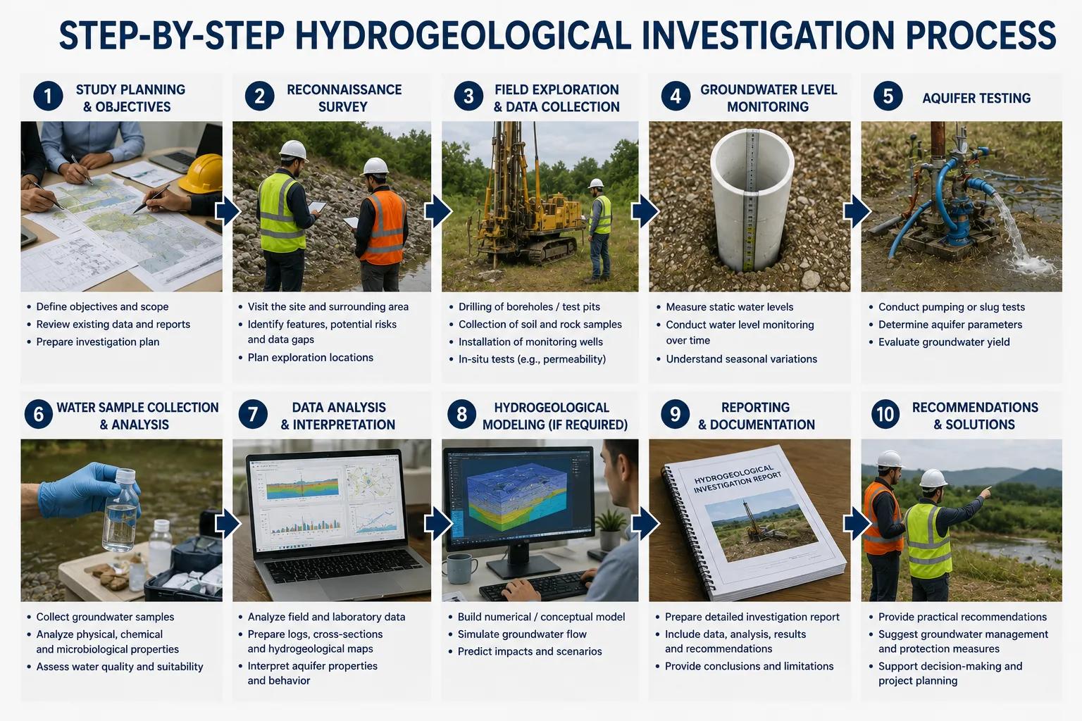
Step-by-Step Hydrogeological Investigation Process
Bhoojal Survey follows a rigorous, field-tested investigation workflow that ensures every groundwater exploration project is conducted with scientific accuracy and professional integrity:
01 Site Inspection
Initial reconnaissance visit to assess site conditions, accessibility, land use, and visible geological features.
02 Geophysical Survey Planning
Design of geophysical survey grid, selection of appropriate methods (VES, ERT, EM), and instrument calibration.
03 Data Collection & Analysis
Processing of raw field data using professional interpretation software to generate resistivity profiles and subsurface models.
04 Groundwater Potential Evaluation
Assessment of groundwater yield potential, recharge capacity, and long-term sustainability of identified aquifers.
05 Technical Report Preparation
Preparation of a comprehensive hydrogeological investigation report with maps, cross-sections, and drilling recommendations.
06 Project Planning Support
Post-report consultation to assist clients with project execution, drilling contractor briefing, and water resource planning.
Benefits of Professional Hydrogeological Investigation Services
Engaging a qualified hydrogeological consultancy delivers measurable, project-wide benefits that far outweigh the cost of the investigation itself:
✔ Accurate Groundwater Detection
Eliminates guesswork with data-driven aquifer identification and yield prediction.
✔ Reduced Drilling Failure Risk
Minimises the probability of dry holes, low-yield wells, and expensive re-drilling.
✔ Sustainable Water Resource Planning
Ensures groundwater extraction remains within safe, long-term sustainable limits.
✔ Significant Cost Savings
Optimised borewell depth and location recommendations reduce total drilling and infrastructure costs.
✔ Improved Infrastructure Planning
Provides accurate water availability data to support project feasibility, design, and financing.
How Bhoojal Survey Can Help You
Bhoojal Survey is a dedicated professional hydrogeological and geophysical survey consultancy serving clients across India. Whether you are planning a single borewell or a large-scale water resource project, here is how we make a difference:
Site-Specific Groundwater Investigation
We conduct customised hydrogeological investigations tailored to the specific geology, terrain, and project requirements of your site — delivering precise, actionable results rather than generic survey data.
Experienced Hydrogeologists & Survey Experts
Our team of qualified hydrogeologists, geophysicists, and field survey technicians brings decades of hands-on experience in borewell site investigation, aquifer study, and groundwater resource assessment across diverse geological settings in India.
Advanced Groundwater Detection Instruments
We use industry-leading geophysical instruments — SSRMPATS, GER DETECT, PQWT, and resistivity meters — to deliver the most accurate subsurface groundwater detection available without the need for trial drilling.
Fast Turnaround & Professional Reporting
We understand project timelines are critical. Bhoojal Survey delivers rapid field surveys and professionally prepared investigation reports with detailed maps, depth profiles, and drilling recommendations — ready to hand to your contractor or project team.
Pan-India Survey Coverage
We serve infrastructure developers, borewell contractors, government departments, mining companies, EPC firms, and agricultural projects across all major Indian states — from Rajasthan's arid zones to the hard-rock terrains of Deccan Plateau and alluvial plains of the Gangetic belt.
End-to-End Project Support
From initial site reconnaissance to post-drilling groundwater yield verification, Bhoojal Survey provides comprehensive project support — ensuring your groundwater investment delivers results at every stage.
Customised Hydrogeological Investigation Solutions
Every project is unique. We design our investigation methodology to match the scale, budget, and technical complexity of your project — whether it is a single borewell location or a regional aquifer mapping assignment.
Trusted by Diverse Industries
Our clients include irrigation project planners, mining companies, construction developers, urban local bodies, agricultural cooperatives, and industrial corporations — all of whom rely on Bhoojal Survey for scientific, reliable groundwater investigation services.
Why Choose Bhoojal Survey for Hydrogeological Investigation?
Pan-India Coverage
All geological terrains & major states
Advanced Instruments
SSRMPATS, GER DETECT, PQWT & Resistivity Meters
Scientific Methodology
VES, ERT, GIS, Remote Sensing & Field Geology
Qualified Team
Certified Hydrogeologists & Survey Professionals
Fast Reporting
Detailed Technical Reports with Drilling Recommendations
Proven Track Record
Hundreds of Successful Borewell Location Surveys
Sector Expertise
Mining, Agriculture, Industry, Infrastructure & Government
Client-Centric Approach
Customised Solutions for Every Project Requirement
Conclusion
Hydrogeological investigation is not merely a technical exercise — it is the critical first step that determines the success or failure of every groundwater project. In a country like India, where water scarcity increasingly challenges agriculture, industry, and urban development, the ability to precisely locate, quantify, and manage groundwater resources is of national strategic importance.
At Bhoojal Survey, we combine field-proven hydrogeological expertise, advanced geophysical survey technology, and rigorous scientific methodology to deliver investigation results that project teams can trust and build upon. Our professional groundwater investigation services have supported borewell drilling projects, irrigation schemes, industrial water supply systems, and infrastructure developments across India's most challenging geological terrains.
If you are planning a borewell, a water resource project, or require a professional hydrogeological site investigation anywhere in India — Bhoojal Survey is your trusted partner.
Get Expert Hydrogeological Investigation for Your Project
Contact Bhoojal Survey today for a professional groundwater survey consultation.
■ Call Us | ■ Email Us | ■ Visit: www.bhoojalsurney.com
Frequently Asked Questions (FAQs)
Q1. What is hydrogeological investigation?
Hydrogeological investigation is a systematic scientific process of studying subsurface groundwater — its occurrence, distribution, movement, depth, and quality within geological formations. It integrates geology, geophysics, hydrology, and GIS analysis to provide accurate groundwater resource data for borewell drilling and water resource planning projects.
Q2. Why is hydrogeological survey important for borewell drilling?
Without a proper hydrogeological survey, borewell drilling is essentially guesswork. A scientific survey identifies the exact location, depth, and expected yield of groundwater before a single metre is drilled — significantly reducing the risk of dry holes, failed boreholes, and wasted investment.
Q3. How is groundwater detected during a hydrogeological investigation?
Groundwater is detected using geophysical methods including Vertical Electrical Sounding (VES), Electrical Resistivity Tomography (ERT), and electromagnetic surveys. These non-invasive techniques map subsurface resistivity variations to distinguish water-bearing formations from dry rock, identifying productive aquifer zones without drilling.
Q4. What instruments are used in groundwater surveys?
Bhoojal Survey uses advanced instruments including the SSRMPATS Instrument, GER DETECT, and PQWT systems — alongside resistivity meters, GPS survey equipment, and GIS mapping software — to ensure accurate and reliable groundwater detection and hydrogeological mapping.
Q5. How long does a hydrogeological investigation take?
The duration depends on the project scale and site complexity. A standard single-site borewell location investigation typically takes 1–2 days for field survey and 2–4 days for data analysis and report preparation. Large-scale regional hydrogeological investigations may take several weeks.
Q6. Which industries require hydrogeological investigation services?
Hydrogeological investigation is required across a broad range of sectors including agriculture and irrigation, mining and mineral extraction, infrastructure and construction, industrial manufacturing, urban water supply, environmental consultancy, and government water resource departments.
Q7. What is the difference between hydrogeological investigation and a geophysical survey?
A geophysical survey is one component within a broader hydrogeological investigation. The full investigation also includes geological mapping, remote sensing analysis, GIS mapping, aquifer characterisation, recharge assessment, and technical report preparation — of which the geophysical survey provides the subsurface detection data.
Q8. Can hydrogeological investigation guarantee groundwater?
No scientific survey can guarantee groundwater with 100% certainty, as subsurface conditions are complex. However, a professional hydrogeological investigation by Bhoojal Survey dramatically increases the probability of successful borewell drilling by identifying the most favourable locations and depth intervals based on verified geophysical and geological data.