Water is the foundation of every industry, every farm, and every community. Yet in a country as large and geologically diverse as India, groundwater does not reveal itself easily. A Groundwater Resource Survey is the scientific process of locating, measuring, and evaluating subsurface water resources — giving developers, planners, and government bodies the factual foundation they need before investing in any water-dependent project.
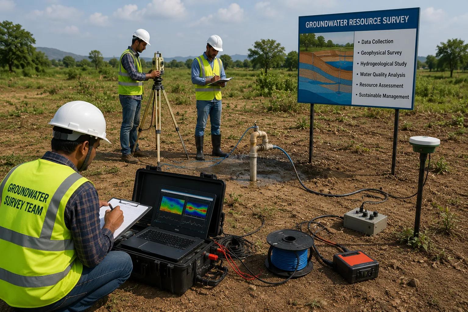
At Bhoojal Survey, we combine decades of hydrogeological field experience with advanced geophysical instruments and satellite-based analysis to deliver reliable groundwater resource assessments across the country. Whether you are planning a large-scale industrial plant, an irrigation network, a mining operation, or a rural water supply scheme, our groundwater investigation services eliminate guesswork and dramatically improve borewell success rates.
A groundwater resource survey is a comprehensive hydrogeological and geophysical investigation carried out to assess the occurrence, depth, quality, and extractable yield of subsurface water within a defined project area. It is not simply pointing at a spot and predicting water — it is a structured, data-driven process that maps aquifer geometry, analyses rock permeability, and quantifies recharge and storage potential.
The survey integrates surface geology, subsurface resistivity data, satellite imagery, and hydrological records to produce a groundwater resource assessment report that guides drilling decisions, water supply planning, and long-term groundwater management strategies.
- Identifies productive aquifer zones and their depths
- Estimates sustainable groundwater yield before drilling
- Maps groundwater recharge areas and seasonal fluctuations
- Assesses groundwater quality and contamination risks
- Provides scientific basis for borewell site selection
In India, over 60% of irrigation requirements and nearly 85% of rural drinking water needs are met from groundwater. Yet blind drilling — without prior scientific investigation — wastes crores of rupees and leaves projects without water. A professional groundwater availability survey directly addresses these risks.
- Borewell Success Rate: Geophysically guided drilling has been shown to improve success rates by 60–80% compared to undirected drilling.
- Industrial Water Security: Manufacturing plants and processing industries can plan infrastructure confidently when groundwater yield data is available upfront.
- Sustainable Agricultural Planning: Irrigation projects require knowledge of aquifer recharge rates to avoid long-term depletion.
- Regulatory Compliance: Central Ground Water Board (CGWB) guidelines encourage scientific groundwater investigation before major extraction.
- Risk Mitigation: Knowing aquifer limits prevents over-extraction, land subsidence, and water quality degradation.
Hydrogeological Survey
The foundation of any scientific groundwater investigation is a thorough hydrogeological survey. Our experts study regional and local geology, analyse rock types, fault and fracture patterns, soil permeability, and drainage basin characteristics to understand how and where groundwater accumulates. This geological assessment identifies potential aquifer formations — whether alluvial, fractured hard rock, or weathered zones — and provides the conceptual model that guides subsequent geophysical work.
Geophysical Resistivity Survey
Electrical resistivity imaging is the most widely used geophysical technique for groundwater detection. Different subsurface materials — dry rock, clay, saturated sandstone, fractured basalt — conduct electricity differently. By injecting controlled electrical current into the ground and measuring voltage response, our instruments build a detailed picture of subsurface resistivity variations, pinpointing water-bearing layers with high accuracy.
Our team conducts hydrogeological survey using SSRMPATS Instrument, GER DETECT, and PQWT at site for open well / borewell location — ensuring that resistivity data is captured at the right depth intervals and spatial resolution for each project.
Satellite Remote Sensing & GIS Analysis
Modern groundwater resource assessment integrates satellite imagery and Geographic Information System (GIS) analysis to identify recharge zones, lineament structures, watershed boundaries, and land use patterns. Multi-spectral satellite data reveals drainage networks and geological lineaments — fractures and fault lines that act as pathways for groundwater movement. Combined with Digital Elevation Models (DEMs), this analysis produces high-resolution GIS-based groundwater mapping that covers large project areas efficiently before ground-level geophysical work begins.
Accurate groundwater surveys demand precision instruments. Bhoojal Survey deploys advanced groundwater and geophysical survey solutions that are proven in Indian geological conditions:
- SSRMPATS Resistivity Meter: Multi-electrode resistivity profiling for deep aquifer imaging
- GER DETECT System: High-sensitivity ground survey instrument for open well and borewell location
- PQWT Instrument: Portable multi-functional groundwater detector for rapid field assessment
- GPS Survey Equipment: Precise geo-referenced data collection for aquifer mapping
- GIS Software (ArcGIS / QGIS): Spatial analysis, groundwater mapping, and report generation
- Satellite Remote Sensing Platforms: Landsat, Sentinel, and IRS data for watershed and lineament analysis
- Groundwater Monitoring Systems: Data loggers and water-level sensors for long-term aquifer monitoring
This combination of field instruments and digital analysis tools enables scientific groundwater investigation and aquifer analysis at any scale — from a single borewell site to a regional groundwater management project covering hundreds of square kilometres.
■ Step 1: Site Inspection & Data Collection
Our hydrogeologists visit the project site to collect basic geological, topographical, and hydrological data.
Existing borewell records, water level data, and local geological maps are reviewed.
■ Step 2: Hydrogeological Assessment
Regional geology is studied to identify aquifer types — alluvial plains, fractured hard rock, or semi-consolidated formations — and to determine the depth range of productive zones.
■ Step 3: Satellite & GIS Analysis
Satellite imagery is processed to map lineaments, recharge zones, drainage patterns, and land use. GIS layers are created for spatial groundwater resource mapping.
■ Step 4: Geophysical Resistivity Survey
Field teams conduct electrical resistivity surveys using SSRMPATS, GER DETECT, and PQWT instruments across the project area to image subsurface water-bearing formations.
■ Step 5: Aquifer Mapping & Data Interpretation
Resistivity data is processed and modelled. Aquifer depth, thickness, lateral extent, and estimated yield are determined through inverse modelling and hydrogeological interpretation.
■ Step 6: Groundwater Recharge Assessment
Recharge potential is analysed based on rainfall records, soil infiltration rates, and identified recharge zones to estimate sustainable extraction limits.
■ Step 7: Technical Report Preparation
A detailed groundwater resource survey report is prepared, including aquifer maps, resistivity sections, borewell site recommendations, and estimated yield parameters.
■ Step 8: Recommendations & Consultancy
Bhoojal Survey provides actionable recommendations for borewell design, drilling depth, casing specifications, and long-term groundwater management strategy.
Understanding what controls groundwater availability is central to any reliable subsurface water survey. Key factors include:
- Geological Formations: Hard rock terrains have lower porosity than alluvial formations; fractures and weathered zones are critical water-bearing horizons in Deccan Trap and Peninsular India.
- Rainfall and Recharge Patterns: Annual rainfall, monsoon intensity, and surface infiltration directly determine how much water enters the aquifer each year.
- Soil and Rock Permeability: Coarse sand and gravel transmit water freely; clay layers act as aquitards that confine or block groundwater movement.
- Extraction Rates: Over-pumping reduces water table levels, reduces borewell yields, and can permanently damage aquifer structure.
- Seasonal Fluctuation: Groundwater levels in India typically drop 3–8 metres between pre-monsoon and post-monsoon seasons, affecting borewell productivity planning.
8. Benefits of Professional Groundwater Resource Survey Services
- Higher Borewell Success Rate: Geophysically identified drilling sites have significantly higher success rates than undirected drilling.
- Cost Savings: Avoiding dry or low-yield boreholes saves lakhs in drilling costs.
- Sustainable Water Management: Aquifer data enables scientifically managed extraction that protects long-term water availability.
- Regulatory Readiness: Documented groundwater surveys satisfy EIA, environmental clearance, and CGWB submission requirements.
- Accurate Planning: Engineers and project developers can design water supply infrastructure with real yield data instead of estimates.
- Reduced Environmental Risk: Identifying recharge zones and aquifer limits prevents over-extraction and groundwater depletion.
Bhoojal Survey is a dedicated groundwater resource consultancy with deep expertise in hydrogeological investigation, geophysical survey, and aquifer analysis across diverse geological settings in India. Here is exactly how we help our clients succeed:
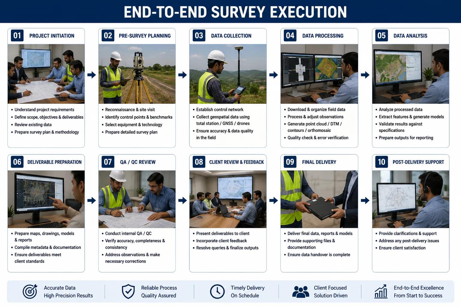
■ End-to-End Survey Execution
From initial site reconnaissance to final technical report, we manage the entire groundwater resource survey process — you receive a complete, decision-ready assessment without needing to coordinate multiple vendors.
■ Customised Investigation for Every Project Type
Industrial plants have different groundwater needs than irrigation schemes or mining operations. We tailor survey scope, instrument selection, and reporting format to your specific project requirements and budget.
■ Advanced Geophysical Detection Technology
Our SSRMPATS, GER DETECT, and PQWT instruments — combined with GIS and satellite analysis — deliver aquifer imaging accuracy that translates directly into higher borewell success rates for our clients.
■ Expert Hydrogeological Interpretation
Collecting resistivity data is only half the work. Our experienced hydrogeologists interpret subsurface data in the context of local geology, monsoon patterns, and existing water level records to produce reliable aquifer maps and yield estimates.
■ Borewell Site Recommendation with Confidence
We do not just survey — we recommend exact borewell locations, target depths, casing design, and expected yield so your drilling contractor can begin work with a clear, scientifically backed plan.
■ Groundwater Recharge & Management Advisory
Beyond locating water, we advise on sustainable extraction limits, recharge enhancement measures, and long-term monitoring strategies to protect your groundwater asset across seasons and years.
■ Pan-India Project Coverage
From alluvial plains of Punjab and Uttar Pradesh to the hard rock terrain of Rajasthan, Karnataka, and
Maharashtra — our teams are equipped and experienced to operate in every major hydrogeological region of India.
■ Fast Turnaround & Clear Reporting
We understand that project timelines are tight. Our field surveys are executed efficiently, and technical reports are delivered in clear, client-friendly language with maps, sections, and actionable recommendations.
■ Support for Government & Regulatory Submissions
Our groundwater survey reports meet CGWB, State Ground Water Board, and environmental clearance standards — making us a trusted partner for government agencies and consultants preparing statutory submissions.
■ Long-Term Monitoring & Consultancy
Post-drilling, we support clients with borewell yield testing, water quality analysis, and seasonal groundwater monitoring programmes to ensure their water supply remains reliable year after year.
Experienced Team
Hydrogeologists and geophysicists with 15+ years of field experience across Indian geology
Advanced Technology
SSRMPATS, GER DETECT, PQWT instruments + GIS + satellite remote sensing
Pan-India Coverage
Survey teams operational across all major states and geological regions
Accurate Reporting
Detailed technical reports with aquifer maps, resistivity sections, and borewell recommendations
Fast Turnaround
Efficient field operations and prompt report delivery to match project timelines
All Sector Experience
Industrial, agricultural, mining, government, infrastructure, and commercial projects
Regulatory Compliance
Reports structured for CGWB, State Board, and EIA submission requirements
Customised Solutions
Survey scope and methodology tailored to each client's project goals and budget
Groundwater is a finite, invisible resource — and decisions made without scientific investigation can be costly, irreversible, and project-threatening. A professional groundwater resource survey by Bhoojal Survey gives you the data, the maps, and the expert interpretation you need to drill with confidence, plan water supply infrastructure accurately, and manage groundwater sustainably over the long term.
From hydrogeological field assessment and geophysical resistivity imaging to GIS-based aquifer mapping and detailed technical reporting, our end-to-end groundwater resource assessment services are trusted by industrial developers, agricultural project managers, mining companies, and government water authorities across India.
Q: What is a groundwater resource survey?
A groundwater resource survey is a scientific investigation combining hydrogeological, geophysical, and remote sensing methods to assess the occurrence, depth, yield, and quality of subsurface water in a given area. It is conducted before borewell drilling or water resource development projects to ensure accuracy and reduce risk.
Q: Why is groundwater investigation important before drilling a borewell?
Undirected drilling in India has a high failure rate — often exceeding 40% in hard rock areas. A geophysical groundwater investigation identifies the most productive aquifer zones, recommends optimal drilling depth and location, and dramatically improves borewell success rates while reducing unnecessary drilling costs.
Q: How is groundwater detected scientifically?
Groundwater is detected using electrical resistivity surveys, which measure how different subsurface materials — rock, clay, water-saturated sand — conduct electricity. Advanced instruments like SSRMPATS, GER DETECT, and PQWT are used to image aquifer formations at depth without any excavation.
Q: What methods are used in a groundwater resource survey?
The primary methods include hydrogeological survey (geological assessment and aquifer identification), geophysical resistivity survey (subsurface imaging using electrical resistivity), and satellite remote sensing with GIS analysis (recharge zone mapping and lineament identification). These are combined to produce a comprehensive groundwater resource assessment.
Q: Which industries and sectors require groundwater resource assessment?
Industries requiring groundwater surveys include manufacturing and industrial plants, mining operations, agricultural irrigation projects, real estate and township developers, infrastructure and construction companies, rural water supply schemes, environmental consultancies, and government water resource departments.
Q: How long does a groundwater resource survey take?
Survey duration depends on project size and scope. A single-site borewell investigation can be completed in 1–3 days. Large-scale regional aquifer mapping for industrial or government projects may take 2–4 weeks, including data analysis and report preparation.
Q: What is included in a groundwater survey technical report?
A professional groundwater survey report from Bhoojal Survey includes hydrogeological interpretation, geophysical resistivity sections, aquifer depth and thickness maps, recommended borewell locations with target depths, estimated yield parameters, and groundwater management recommendations.
Q: Does a groundwater resource survey comply with CGWB and regulatory standards?
Yes. Bhoojal Survey's groundwater resource assessment reports are structured to meet Central Ground Water Board (CGWB), State Ground Water Board, and environmental clearance (EIA) reporting requirements, making them suitable for regulatory submissions and statutory approvals.