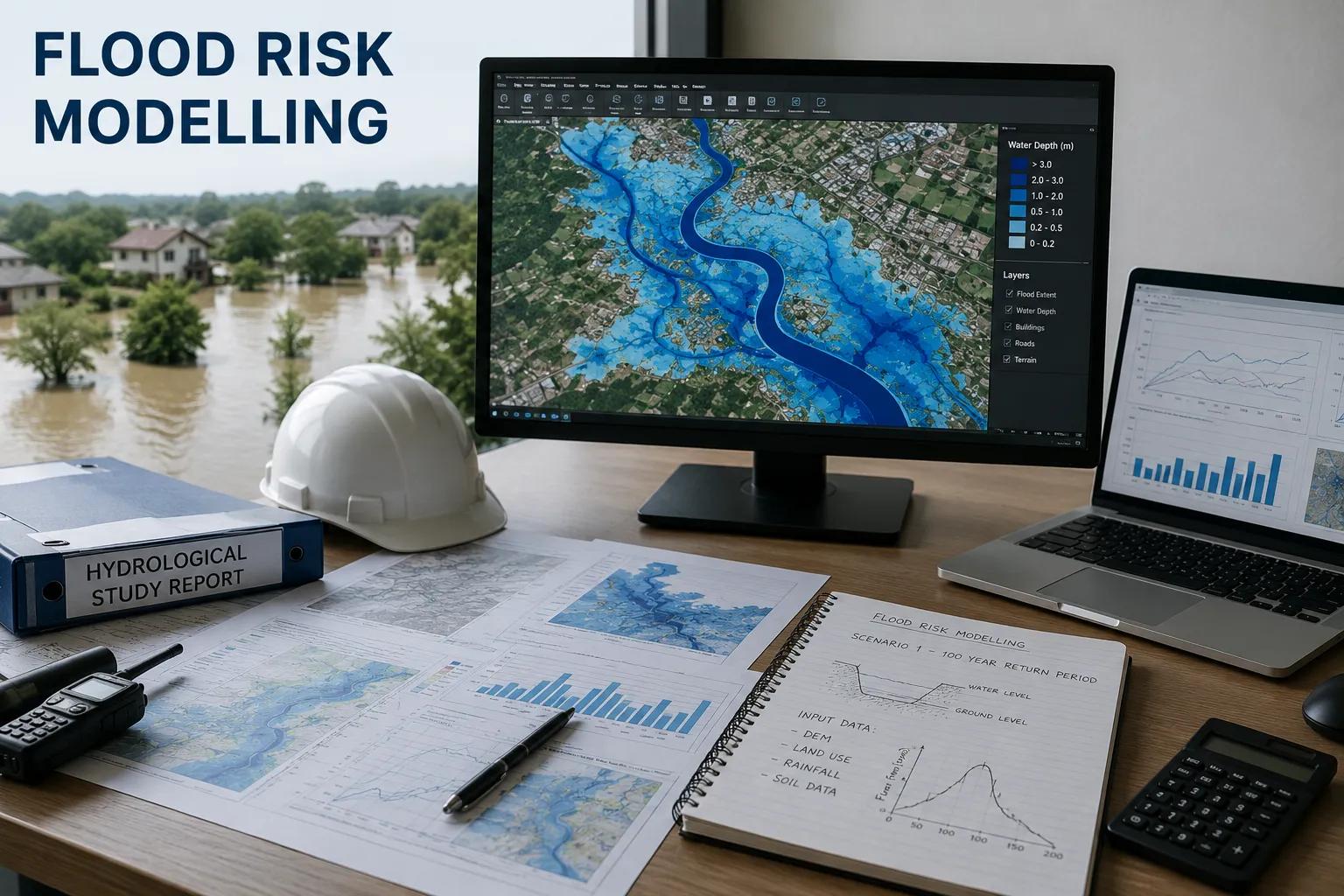
Every year, floods cause billions of rupees in damage to infrastructure, disrupt communities, and threaten lives across India. From the Brahmaputra valley to the coastal plains of Odisha and the urban corridors of Maharashtra, unmanaged flood risk remains one of the most critical engineering challenges of our time. Flood risk modelling is the scientific backbone that enables engineers, planners, and government authorities to predict, assess, and mitigate these risks before they become disasters.
At its core, flood risk modelling integrates hydrological and hydraulic modelling, geospatial analysis, remote sensing, and statistical data to simulate flood behaviour across watersheds, floodplains, and built environments. It answers essential questions: Where will floodwaters reach? How deep will inundation be? Which infrastructure is vulnerable? What design standards are needed?
For infrastructure developers, smart city planners, dam engineers, highway project managers, and environmental consultants, professional flood risk assessment is not optional — it is a prerequisite for sound project planning, regulatory compliance, and long-term asset protection.
What is Flood Risk Modelling?
Flood risk modelling is a multi-disciplinary scientific process that combines hydrology, hydraulics, GIS mapping, and statistical analysis to evaluate the probability, magnitude, and consequences of flood events at a given location. It involves building mathematical representations of rainfall-runoff processes, river flow dynamics, and floodplain inundation patterns to generate accurate flood hazard maps and risk assessments.
A comprehensive flood risk modelling study typically delivers:
- Flood hazard maps showing inundation extent, depth, and velocity
- Flood frequency analysis for 10-year, 50-year, and 100-year return periods
- Floodplain delineation and flood risk zoning
- Infrastructure vulnerability and flood impact analysis
- Flood disaster risk scenarios for planning and design
Unlike basic hydrological surveys, flood risk modelling produces spatially referenced, quantitative results that can directly feed into engineering design, environmental impact assessments, insurance risk analysis, and disaster management frameworks.
Why Flood Risk Modelling is Critical for India's Infrastructure
India experiences some of the world's most intense and geographically varied flood events. Monsoon-driven river flooding, flash floods in hilly terrain, urban waterlogging, and coastal storm surges each require specific modelling approaches. Without rigorous flood simulation analysis, infrastructure projects face enormous financial, structural, and human risk.
Flood Disaster Prevention: Accurate flood prediction modelling helps authorities deploy early warning systems, design adequate flood barriers, and prepare evacuation plans before catastrophic events occur.
Infrastructure Safety: Roads, bridges, dams, railways, and industrial facilities located in flood-prone zones require flood risk evaluation to ensure structural adequacy and longevity.
Urban Drainage Planning: Rapid urbanisation has dramatically altered natural drainage patterns. Flood hazard modelling enables engineers to design drainage networks that handle extreme rainfall events without causing waterlogging.
Environmental Protection: Floodplain mapping services identify ecologically sensitive zones, helping project developers avoid environmental degradation and comply with regulatory requirements.
Climate Change Adaptation: With changing rainfall patterns increasing the frequency of extreme flood events, updated flood risk analysis ensures that infrastructure is designed for future climate scenarios, not just historical data.
Key Applications of Flood Risk Modelling Services
Professional flood risk analysis services are deployed across a wide spectrum of sectors in India:
Urban Flood Management: City municipalities and smart city authorities commission flood hazard assessment surveys to identify vulnerable neighbourhoods, plan stormwater infrastructure, and update master plans with scientifically validated flood zones.
Highway & Bridge Infrastructure: National and state highway projects require site-specific flood risk assessment to determine bridge opening sizes, road embankment heights, and drainage structures capable of handling design flood discharges.
Dam & Reservoir Safety Studies: Hydrological flood modelling is central to dam break analysis, spillway design, and reservoir flood routing — ensuring that storage structures meet safety standards under extreme inflow conditions.
Mining & Industrial Zones: Industrial facilities in river valleys require flood impact analysis to protect plant assets, waste containment structures, and worker safety from flood inundation events.
River Basin Management: Watershed flood modelling supports integrated basin-level water resource planning, enabling irrigation departments and river authorities to manage water allocation and flood control infrastructure effectively.
Coastal Area Flood Risk Analysis: Coastal development projects require specialised flood disaster modelling that integrates storm surge, wave action, sea level rise, and estuarine dynamics — particularly important for ports, coastal highways, and urban coastal zones.
Environmental Impact Assessments: EPC contractors and environmental consultants rely on flood risk analysis to quantify flood-related impacts for EIA reports submitted to regulatory bodies such as MoEFCC.
Agricultural Flood Management: Flood simulation analysis for agricultural areas helps irrigation departments identify areas requiring drainage improvement, embankment construction, or crop insurance risk zoning.
Methods Used in Flood Risk Modelling
Hydrological Modelling
Hydrological flood modelling simulates the transformation of rainfall into surface runoff across a catchment. Using rainfall-runoff models such as HEC-HMS, SWAT, or rational method calculations, hydrologists quantify peak discharge rates and flood hydrographs at critical points in the watershed. Watershed analysis using digital elevation models (DEMs) and land use data enables accurate delineation of sub-catchments and estimation of time of concentration, curve numbers, and baseflow contributions.
Hydraulic Modelling
Hydrodynamic flood modelling translates the discharge outputs from hydrological models into flood inundation maps. Using 1D/2D hydraulic simulation software such as HEC-RAS, MIKE FLOOD, or TUFLOW, engineers model river flow dynamics, floodplain inundation patterns, flow velocities, and flood depths across the study area. This enables accurate floodplain simulation and the identification of flood risk zones at fine spatial resolution.
GIS-Based Flood Mapping
Geospatial flood risk analysis integrates hydraulic model outputs with high-resolution satellite data, topographic surveys, and land use maps using GIS platforms such as ArcGIS and QGIS. The result is detailed flood hazard mapping that visually communicates inundation extents, depths, and risk classifications. Remote sensing tools, including Sentinel-1 SAR imagery and LiDAR-derived DEMs, enhance the accuracy of flood risk mapping in data-sparse regions.
Equipment and Technologies Used in Flood Risk Investigations
Bhoojal Survey deploys a comprehensive suite of advanced instruments and software platforms to deliver accurate, scientifically validated flood risk modelling and hydrological investigation services:
- HEC-HMS and HEC-RAS for hydrological and hydraulic flood simulation modelling
- MIKE FLOOD and TUFLOW for 2D hydrodynamic flood modelling
- ArcGIS and QGIS for GIS-based flood hazard mapping and geospatial analysis
- Sentinel-1 SAR, SRTM, and Cartosat DEM data for remote sensing and digital terrain modelling
- GPS survey equipment and total stations for high-accuracy field topographic surveys
- Automatic water level recorders, discharge gauging stations, and rain gauge networks forhydrological data collection
- Hydrological data processing tools for rainfall-frequency analysis and flood estimation
- Conducting hydrogeological survey using SSRMPATS Instrument, GER DETECT, and PQWT at sitefor open well / borewell location
This combination of advanced flood risk modelling solutions and scientific hydrological investigation and flood analysis enables Bhoojal Survey to deliver technically rigorous, actionable results across all project scales.
Key Factors Affecting Flood Risk
Rainfall Intensity & Patterns: High-intensity, short-duration storms and prolonged monsoon rainfall both generate significantly different flood responses that must be modelled with appropriate return period analysis.
River Discharge Levels: Upstream catchment hydrology, snowmelt contributions, and inter-basin diversions directly influence peak discharge levels that drive floodplain inundation extents.
Terrain & Elevation: Flat alluvial plains, steep mountain catchments, and urban topography each create distinct flood behaviour patterns that require tailored hydraulic modelling approaches.
Land Use Changes: Urbanisation, deforestation, and agricultural expansion significantly increase surface runoff coefficients, accelerating flood peak formation and reducing natural flood attenuation.
Drainage System Capacity: Inadequate culverts, blocked drainage channels, and undersized stormwater systems are major contributors to localised flood risk in both urban and rural settings.
Climate Change Impacts: Shifting monsoon patterns, increased frequency of extreme rainfall events, and sea level rise are progressively altering historical flood frequency relationships, making climate-adjusted flood forecasting modelling essential.
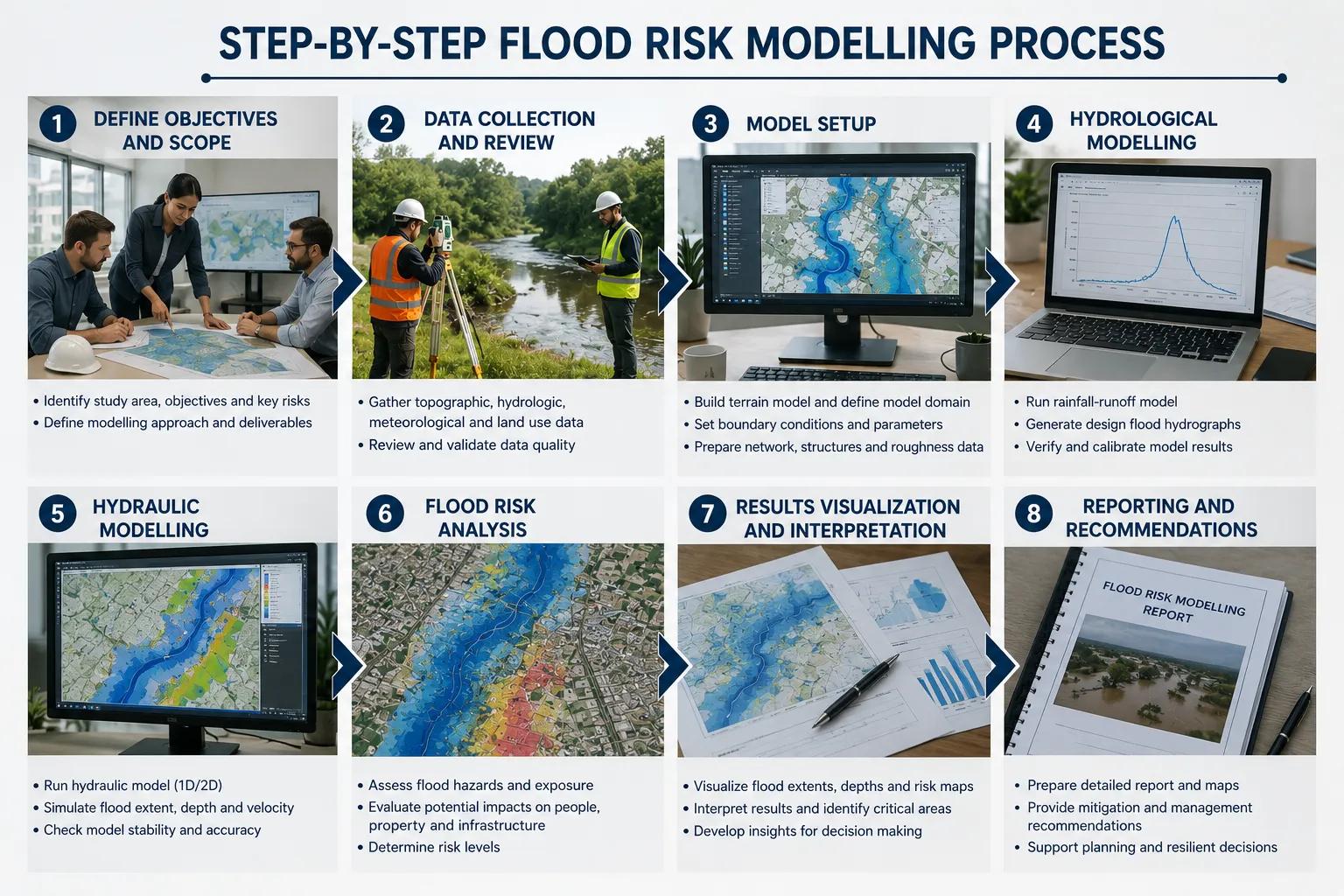
Step-by-Step Flood Risk Modelling Process
01 Project Requirement Analysis
Define study objectives, spatial extent, return periods, and deliverable specifications in consultation with the client and regulatory requirements.
02 Data Collection & Rainfall Analysis
Acquire historical rainfall records, stream gauge data, topographic surveys, and remote sensing datasets. Perform statistical rainfall-frequency analysis for the study catchment.
03 Watershed & Drainage Analysis
Delineate sub-catchment boundaries, estimate catchment parameters, and analyse existing drainage infrastructure using GIS and DEM processing tools.
04 Hydrological Modelling
Build and calibrate rainfall-runoff models to generate design flood hydrographs for multiple return periods at key points across the watershed.
05 Hydraulic Simulation
Develop 1D/2D hydrodynamic models of the river/floodplain system and run flood simulation analysis for all design scenarios, including extreme events.
06 Floodplain Mapping
Generate GIS-based flood inundation maps showing flood extent, depth, and velocity for each modelled flood scenario.
07 GIS-Based Flood Risk Analysis
Overlay flood maps with infrastructure, land use, and population data to quantify exposure and produce flood risk zoning maps.
08 Model Validation & Calibration
Validate model results against historical flood records, satellite flood extent data, and field observations to ensure reliability.
09 Risk Evaluation & Scenario Analysis
Assess flood risk under current conditions, future development scenarios, and climate change projections to support long-term planning.
10 Technical Reporting & Recommendations
Prepare comprehensive flood risk reports with engineering recommendations for flood mitigation, drainage design, and risk management.
Benefits of Professional Flood Risk Modelling Services
- Accurate flood prediction that reduces project uncertainty and design risk
- Improved infrastructure safety through evidence-based engineering design
- Cost-effective disaster mitigation that avoids costly post-construction retrofits
- Regulatory compliance with NDMA, MoEFCC, IRC, IS codes, and state flood control guidelines
- Better environmental planning through scientifically validated floodplain delineation
- Reduced insurance premiums and financing risks for infrastructure projects
- Enhanced disaster preparedness through scenario-based flood risk evaluation
How Bhoojal Survey Can Help Your Project
Bhoojal Survey brings together deep technical expertise in hydrological investigation, flood risk modelling, groundwater survey, GIS analysis, and environmental infrastructure consultancy to provide end-to-end flood risk solutions for projects across India. Here is how our team can directly support your needs:
Site-Specific Flood Risk Assessment
Whether you are developing a highway project in a flood-prone river valley, planning an industrial facility near a watercourse, or designing a residential township in an urban floodplain, Bhoojal Survey conducts tailored flood hazard assessment surveys to quantify site-specific flood risk and guide your design decisions.
Hydrological & Hydraulic Flood Modelling
Our engineers build project-specific rainfall-runoff and hydrodynamic models calibrated with local data. We deliver design flood discharges, flood inundation maps, and hydraulic design parameters — everything your structural and civil engineers need to design flood-resilient infrastructure.
GIS-Based Flood Hazard Mapping
Using satellite imagery, LiDAR, and high-resolution DEMs, we produce detailed floodplain mapping services that clearly show inundation extents, depth classifications, and flood risk zones — ready for integration into master plans, EIA reports, or insurance assessments.
Dam Safety & Reservoir Flood Studies
For dam and reservoir projects, Bhoojal Survey conducts PMF (Probable Maximum Flood) estimation, dam break analysis, and flood routing studies that meet CWC and state dam safety guidelines.
Climate Change Flood Risk Scenarios
We incorporate future climate projections into our flood forecasting modelling to help clients future-proof infrastructure against changing rainfall patterns and increasing flood frequency — essential for projects with a 30–50 year design life.
Regulatory Compliance & EIA Support
Our professionally prepared flood risk reports are structured to meet the requirements of NDMA flood management guidelines, MoEFCC environmental clearances, IRC highway design standards, and state flood control authority specifications.
Rapid Turnaround & Pan-India Coverage
With operational capacity across India — from the Himalayan foothills to the Deccan Plateau and coastal zones — Bhoojal Survey delivers fast, reliable flood risk analysis services that keep your project timelines on track.
Why Choose Bhoojal Survey for Flood Risk Modelling
In a field where the quality of modelling data directly determines the safety of multi-crore infrastructure investments, choosing the right flood risk modelling consultancy is a critical decision. Bhoojal Survey offers:
- Multidisciplinary team of hydrology, hydraulics, GIS, and geospatial engineering specialists
- Advanced hydrological modelling software and industry-standard hydraulic simulation platforms
- Proven methodology integrating field investigations with computational modelling
- Deep understanding of Indian hydrology — monsoon dynamics, semi-arid catchments, Himalayanrivers, coastal estuaries
- Comprehensive flood risk assessment reports aligned with national and state regulatory standards
- Customised flood risk evaluation for infrastructure projects of all scales
- Fast project mobilisation and pan-India survey capability
- Transparent, data-driven flood risk analysis with fully documented model assumptions and limitations
Conclusion
Flood risk modelling is no longer a luxury reserved for major dam projects — it is a fundamental requirement for any infrastructure, urban development, or environmental project located in or near flood-prone areas. As India continues to expand its infrastructure, urbanise rapidly, and face an increasingly unpredictable climate, the demand for rigorous, scientifically defensible flood risk assessment has never been greater.
Bhoojal Survey provides the technical expertise, proven methodology, and advanced flood simulation analysis capabilities that infrastructure developers, government authorities, and project planners need to make informed, flood-resilient design decisions. From watershed flood modelling and floodplain delineation to hydrodynamic simulation and flood risk reporting, our team delivers results you can rely on.
Contact Bhoojal Survey today for a consultation on your flood risk modelling requirements. Let our expert hydrologists and flood risk engineers help protect your project — and the communities it serves.
Frequently Asked Questions (FAQ)
Q: What is flood risk modelling?
A: Flood risk modelling is a scientific process that combines hydrological and hydraulic analysis, GIS mapping, and statistical techniques to predict the probability, extent, depth, and consequences of flood events at a given location. It produces flood hazard maps and risk assessments used in infrastructure planning, disaster management, and environmental impact assessment.
Q: Why is flood risk assessment important for infrastructure projects in India?
A: India's diverse topography and intense monsoon rainfall make flood risk a critical design consideration for roads, bridges, dams, industrial facilities, and urban developments. A professional flood risk assessment ensures that structures are designed to safely withstand design flood events, reducing the risk of failure, financial loss, and harm to communities.
Q: How does flood risk modelling work?
A: The process begins with data collection — rainfall records, topographic surveys, and river discharge data — followed by hydrological modelling to estimate design flood flows, hydraulic simulation to map inundation patterns, and GIS-based analysis to produce spatially referenced flood risk maps and technical reports.
Q: Which industries require flood risk modelling services?
A: Infrastructure developers (roads, bridges, railways), dam and reservoir project authorities, urban local bodies and smart city planners, mining and industrial facility operators, coastal development projects, and environmental consultants preparing EIA reports all require professional flood risk modelling services.
Q: How long does a flood risk assessment take?
A: Project duration depends on study area size, data availability, and regulatory requirements. A site-specific assessment for a single project may take 3–6 weeks, while a comprehensive river basin-level flood risk study may require 3–6 months including field data collection, modelling, and validation.
Q: What data is required for flood risk modelling?
A: Key data inputs include historical rainfall records (IMD data, gauge station records), stream flow gauge data, topographic surveys or LiDAR DEMs, land use and land cover maps, soil and geology data, and existing drainage infrastructure details.
Q: Can Bhoojal Survey provide flood risk modelling for climate change scenarios?
A: Yes. Bhoojal Survey incorporates downscaled climate model projections into flood forecasting modelling to assess how changing rainfall patterns and increased extreme event frequency will affect flood risk over a project's design life — providing climate-resilient engineering recommendations.
Q: Does Bhoojal Survey provide floodplain mapping services across India?
A: Yes. Bhoojal Survey provides floodplain mapping services and flood risk analysis services for projects across India, covering Himalayan river systems, peninsular rivers, semi-arid catchments, and coastal zones, using satellite data, field surveys, and advanced GIS-based flood modelling.