Introduction
Every year, floods cause enormous damage to infrastructure, agriculture, and human lives across India. From the Brahmaputra basin in Assam to the coastal lowlands of Odisha and the urban drainage systems of Mumbai, the need for scientifically driven flood prediction and risk assessment has never been more critical.
Flood modelling is the process of using hydrological and hydraulic data, computational tools, and geospatial analysis to simulate how floodwaters behave — where they flow, how deep they get, how fast they move, and which areas are most at risk. It converts raw rainfall and river data into actionable intelligence for engineers, planners, and project developers.
For infrastructure developers, EPC contractors, industrial project owners, and government agencies working across India, professional flood modelling services are no longer optional — they are a foundational requirement for safe, compliant, and resilient project design. Bhoojal Survey delivers advanced flood modelling and hydraulic analysis solutions backed by experienced hydrological experts and proven field methodology.
What is Flood Modelling?
Flood modelling is a scientific method used to predict, simulate, and analyse flood behaviour within a defined watershed, river basin, or urban drainage catchment. It integrates hydrological modelling — which examines rainfall-runoff relationships — with hydraulic modelling, which simulates the movement, velocity, and depth of water through channels, floodplains, and drainage networks.
At its core, flood modelling answers three essential questions:
- Where will floodwaters go?
- How deep and fast will the flow be?
- What infrastructure, land, or communities are at risk?
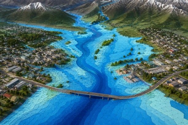
The outputs include floodplain maps, inundation extent models, hazard zone classifications, and engineering recommendations — all of which are essential for flood risk assessment, disaster preparedness, environmental impact analysis, and infrastructure design.
Modern flood models combine satellite remote sensing, GIS mapping, Digital Elevation Models (DEMs), and real-time hydrological data to produce highly accurate simulations across varied terrain — from mountain river systems to urban drainage networks and coastal zones.
Why Flood Modelling is Important
India is among the world's most flood-vulnerable countries. The combination of monsoon-driven rainfall, complex river systems, rapid urbanisation, and changing climate patterns makes flood risk assessment a critical engineering discipline.
Infrastructure safety is the most immediate reason. Roads, bridges, substations, solar plants, industrial facilities, and residential developments built without proper flood hazard mapping face severe risks — structural damage, operational disruption, liability exposure, and in some cases, complete loss.
Disaster preparedness and mitigation depend on knowing which areas will flood, how severely, and how quickly. This knowledge guides evacuation planning, emergency response logistics, and the placement of critical facilities like hospitals and command centres.
Urban planning and land use management require flood risk intelligence to zone areas correctly, design stormwater management systems, and protect communities from future inundation. Smart city projects across India increasingly mandate hydrological modelling as part of their development approval process.
Environmental sustainability is another dimension. Flood modelling supports environmental impact assessments (EIAs), river basin management plans, and climate change adaptation strategies — ensuring that infrastructure development does not worsen flood risks for downstream communities.
For government contractors, construction companies, solar plant developers, telecom infrastructure projects, and mining operations, accurate flood prediction analysis is also a regulatory requirement and a project financing consideration.
Applications of Flood Modelling
Professional flood modelling services are applied across a wide range of project types and industries:
Urban Flood Management — Simulating flood behaviour in cities and towns to design effective stormwater management networks, drainage systems, and retention infrastructure.
River Flood Analysis — Modelling river flow dynamics along major and minor river systems to identify high-risk zones, floodplain boundaries, and safe development corridors.
Dam Safety Assessment — Analysing dam break scenarios, reservoir inundation extents, and downstream flood risks as part of dam safety reviews and emergency action planning.
Highway and Bridge Design — Determining design flood levels and hydraulic loads at river crossings, culverts, and bridge foundations to ensure structural adequacy.
Smart City Planning — Supporting integrated urban drainage design, flood-resilient land use planning, and green infrastructure placement.
Industrial Infrastructure Planning — Assessing flood exposure for solar power plants, substations, factories, warehouses, and logistics hubs to guide site selection and protective design.
Coastal Flood Risk Studies — Modelling storm surge, wave run-up, and sea-level rise scenarios for coastal infrastructure including ports, jetties, and offshore support facilities.
Drainage System Design — Providing hydraulic data to size stormwater drainage networks, retention ponds, and flood diversion channels.
Environmental Impact Assessments — Quantifying flood regime changes caused by proposed infrastructure to satisfy regulatory EIA requirements.
Climate Change Adaptation Studies — Projecting future flood scenarios under different climate trajectories to future-proof long-term infrastructure investments.
Types of Flood Modelling Techniques
Hydrological Flood Modelling
Hydrological modelling focuses on the land phase of the water cycle — how rainfall becomes runoff and eventually reaches rivers and drainage networks. Key elements include:
- Rainfall-runoff relationship: Quantifying what proportion of rainfall flows off the land surface versus infiltrating the soil, based on land cover, soil permeability, slope, and antecedent moisture conditions.
- Watershed analysis: Delineating the catchment area contributing to a specific river reach or outlet point, and analysing how catchment characteristics influence flood response.
- Flood hydrograph prediction: Generating time-based flood flow curves that show how river discharge changes during and after a storm event.
- Catchment area modelling: Simulating the integrated hydrological response of complex, multi-subcatchment drainage basins.
Hydrological models translate storm events — defined by return period and duration — into river discharge values that feed downstream hydraulic analysis.
Hydraulic Flood Modelling
Hydraulic modelling simulates the physical movement of water through channels, floodplains, and built infrastructure. It uses the outputs from hydrological modelling as boundary conditions and calculates:
- River flow dynamics: Velocity, discharge, and water surface profiles along river channels under various flood scenarios.
- Water depth and velocity modelling: Spatial mapping of inundation depth and flow velocity across floodplains, which determines hazard intensity.
- Floodplain analysis: Delineating the geographic extent of flooding for different return periods (10-year, 25-year, 100-year, and extreme events).
- Flow simulation techniques: Using 1D (one-dimensional), 2D (two-dimensional), or combined models to replicate complex flow patterns around structures and through urban areas.
Integrated Flood Modelling
The most powerful and accurate approach combines hydrological and hydraulic modelling in a seamless, coupled workflow. Integrated flood modelling captures the full complexity of real-world flood systems — from rainfall on remote catchments through river routing to urban inundation — providing the highest confidence results for critical infrastructure decisions. Bhoojal Survey applies integrated modelling approaches for major infrastructure projects, dam safety studies, and government flood management programmes.
Software and Tools Used in Flood Modelling
Professional flood modelling relies on specialised engineering software and geospatial tools:
- HEC-HMS (Hydrologic Engineering Center – Hydrologic Modelling System): For hydrological simulation and flood hydrograph generation.
- HEC-RAS (Hydrologic Engineering Center – River Analysis System): Industry-standard 1D/2D hydraulic modelling software, widely used for floodplain mapping and bridge hydraulics.
- SWMM (Storm Water Management Model): For urban drainage and stormwater modelling in cities and industrial areas.
- MIKE FLOOD / MIKE HYDRO: Integrated hydrological and hydraulic modelling platforms for complex flood systems.
- ArcGIS / QGIS: GIS mapping tools for watershed delineation, floodplain visualisation, and spatial flood hazard mapping.
- Remote Sensing Data (Sentinel, Landsat, SRTM DEM): Satellite imagery and elevation data for terrain analysis, land use classification, and model input preparation.
- Python / R for hydrological data processing: Statistical analysis of rainfall records, frequency analysis, and model parameter calibration.
Advanced flood modelling and hydraulic analysis solutions at Bhoojal Survey integrate field-collected data with these tools to produce accurate, defensible, and project-specific flood assessments.
Factors Affecting Flood Modelling Accuracy
Understanding and correctly characterising the following factors is essential for producing reliable flood models:
- Rainfall intensity and duration: The primary driver of flood events; accurate design storm inputs are critical.
- River flow characteristics: Channel geometry, roughness, and conveyance capacity directly affect hydraulic model outputs.
- Watershed size and slope: Larger, steeper catchments produce faster, higher-peak flood responses.
- Land use and urbanisation: Impervious surfaces increase runoff significantly; changes over time must be captured.
- Soil permeability: Determines how much rainfall infiltrates versus runs off; varies widely across India's geological regions.
- Climate variability: Increasing monsoon intensity and changing rainfall patterns require climate-adjusted flood frequency analysis.
- Drainage infrastructure: Existing culverts, channels, and detention basins modify flood behaviour and must be accurately represented.
Bhoojal Survey's scientific hydrological investigation and flood risk assessment methodology accounts for all these variables through rigorous site assessment, data collection, and model calibration — ensuring that outputs are reliable for engineering decision-making.
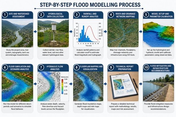
Step-by-Step Flood Modelling Process
Bhoojal Survey follows a structured, technically rigorous workflow for every flood modelling engagement:
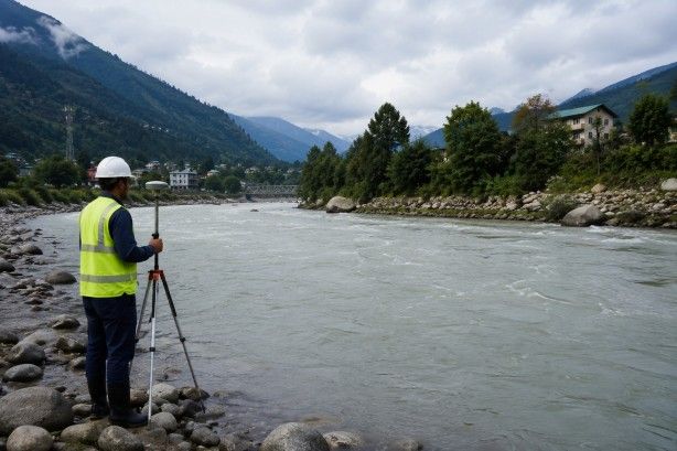
1. Site and Watershed Assessment Field reconnaissance and GIS-based delineation of the project catchment, including identification of key drainage features, land use, and infrastructure elements.
2. Hydrological Data Collection Compilation of long-term rainfall records, river gauge data, and historical flood information from IMD, CWC, and state water resource databases.
3. Rainfall and Runoff Analysis Frequency analysis of rainfall data to define design storms for multiple return periods; derivation of runoff coefficients based on soil and land use survey.
4. River and Drainage Network Mapping High-resolution channel survey, cross-section measurement, and GIS mapping of the drainage network using field survey and satellite data.
5. Model Setup and Parameter Calibration Construction of hydrological and hydraulic models with appropriate parameters; calibration against observed flood events to validate model accuracy.
6. Flood Simulation and Scenario Analysis Running simulations for multiple flood scenarios including design floods, extreme events, and climate change scenarios to understand the full range of flood risk.
7. Hydraulic Flow Analysis Detailed analysis of flow velocities, depths, and hydraulic gradients at critical locations including bridges, culverts, and infrastructure sites.
8. Floodplain Mapping and Visualisation Production of GIS-based floodplain maps showing inundation extent, depth, and hazard zones for each modelled scenario.
9. Technical Report Preparation Comprehensive technical documentation covering methodology, data sources, model description, results, uncertainty assessment, and engineering conclusions.
10. Flood Mitigation and Infrastructure Recommendations Practical engineering recommendations for flood protection measures, site layout adjustments, drainage design, and monitoring systems.
Benefits of Professional Flood Modelling Services
Engaging professional flood modelling consultants delivers tangible benefits across the project lifecycle:
Accurate flood risk assessment reduces uncertainty in site selection and design, preventing costly mistakes and post-construction flood damage.
Better infrastructure planning — flood intelligence guides optimal siting, finished floor levels, access road design, and protective embankment specifications.
Reduced flood damage risk — structures designed to correct flood levels suffer significantly less damage during extreme events, lowering insurance costs and liability exposure.
Improved disaster preparedness — flood maps and scenario analyses support emergency planning, community warning systems, and evacuation route design.
Support for environmental approvals — EIA submissions, CWC clearances, and state water resource authority approvals all benefit from rigorous, independently verified flood modelling.
Reliable long-term flood management strategies — climate-adjusted flood models provide a basis for adaptive management of flood risk over the project's operational life.
Why Choose Bhoojal Survey for Flood Modelling Services
Bhoojal Survey is a specialist survey and investigation consultancy with deep expertise in hydrogeological, geophysical, and geospatial investigations across India. Our flood modelling services are built on the same scientific rigour and field experience that defines our work in groundwater surveys, hydrogeological investigations, and infrastructure testing.
Experienced hydrological and geospatial experts — our team combines academic training in hydrology and water resources engineering with practical experience across industrial, infrastructure, and government projects throughout India.
Advanced flood modelling tools and technologies — we deploy industry-standard hydraulic and hydrological modelling software alongside high-resolution GIS and remote sensing platforms for every project.
Professional data analysis and reporting — every flood modelling engagement produces a detailed technical report meeting the standards required for regulatory submissions, engineering design, and project financing.
Fast and reliable survey results — our streamlined field and office workflow delivers results efficiently without compromising scientific quality.
Pan-India project support — Bhoojal Survey has delivered flood analysis and modelling services across multiple states, covering diverse hydrological and geological conditions from Himalayan river catchments to Deccan plateau watersheds and coastal zones.
Customised flood risk assessment solutions — we tailor our modelling approach to each project's specific requirements, whether a small industrial site or a large linear infrastructure corridor.
Expertise across industry sectors — our clients include solar plant developers, EPC contractors, mining companies, government agencies, highway authorities, telecom tower operators, and real estate developers.
Scientific flood modelling methodology — all work follows established hydrological standards and practices, ensuring technically defensible outputs.
How Bhoojal Survey Can Help
Whether you are planning a new solar power plant and need to confirm flood-safe site levels, designing a highway crossing over a monsoon-prone river, seeking regulatory clearance for an industrial development, or developing an urban stormwater management strategy — Bhoojal Survey provides the technical expertise and field capability to deliver credible, accurate, and actionable flood modelling results.
We work directly with your project team, integrating flood risk intelligence into your design process from the earliest stages to avoid costly redesigns and regulatory delays.
Conclusion
Flood modelling is not just an engineering formality — it is a critical investment in the safety, resilience, and long-term performance of infrastructure projects across India. As climate variability increases flood intensity and frequency, and as regulatory requirements become more stringent, the need for accurate, professionally conducted flood risk assessment has never been greater.
Bhoojal Survey brings the technical depth, practical experience, and advanced toolset required to deliver flood modelling services that stand up to scrutiny — from site-level drainage assessments to basin-scale hydraulic analyses. Our scientific approach, combined with genuine field survey capability and India-wide project coverage, makes us a trusted partner for engineers, developers, and government agencies who need reliable flood intelligence.
Contact Bhoojal Survey today to discuss your flood modelling requirements and receive a customised proposal for flood risk assessment, hydraulic modelling, or watershed analysis services.
Frequently Asked Questions (FAQs)
What is flood modelling?
Flood modelling is a scientific process that uses hydrological and hydraulic analysis to simulate how, where, and to what depth flooding will occur in a given area during storm or river flood events. It combines rainfall data, topographic surveys, river flow measurements, and computational software to produce flood maps, hazard assessments, and engineering recommendations.
Why is flood modelling important for infrastructure projects?
Infrastructure built without flood risk assessment can suffer serious damage during extreme rainfall or river flood events. Flood modelling identifies the flood hazard at a site, informs the design of protective measures, and supports regulatory approvals — reducing risk to both the asset and the people who use it.
What software is used for flood modelling?
Common tools include HEC-HMS and HEC-RAS for hydrological and hydraulic modelling, MIKE FLOOD for integrated simulations, SWMM for urban drainage, and ArcGIS/QGIS for geospatial mapping. The choice of software depends on project type, scale, and data availability.
How long does a flood modelling study take?
The duration depends on project scope and data availability. A focused site-level flood risk assessment for an industrial or infrastructure project typically takes 2–4 weeks. Larger basin-scale studies or those requiring extensive field data collection may take 6–12 weeks or more.
Which industries require flood modelling services?
Flood modelling services are required across a wide range of sectors including solar and renewable energy, EPC contracting, highway and bridge engineering, dam and reservoir management, urban development, mining, telecom infrastructure, airports, and government-led flood management programmes.
What data is required for flood modelling?
Core data requirements include historical rainfall records, river gauge data, Digital Elevation Model (DEM) data, land use and soil maps, channel survey data (cross-sections, roughness), and details of existing drainage infrastructure. Bhoojal Survey assists clients in sourcing data from IMD, CWC, state agencies, and satellite platforms where needed.
What is the difference between hydrological and hydraulic modelling?
Hydrological modelling converts rainfall into river flow — it simulates how a catchment responds to storm events to produce flood discharge values. Hydraulic modelling then uses those discharge values to simulate how water moves through channels and across floodplains, producing maps of inundation depth, extent, and velocity. Both are typically used together in a complete flood modelling study.
Can flood modelling support environmental clearance applications?
Yes. Flood modelling outputs — including floodplain maps, flood frequency analysis, and impact assessments — form a standard component of Environmental Impact Assessment (EIA) submissions, CWC technical clearances, and state water resource authority approvals for infrastructure projects in India.