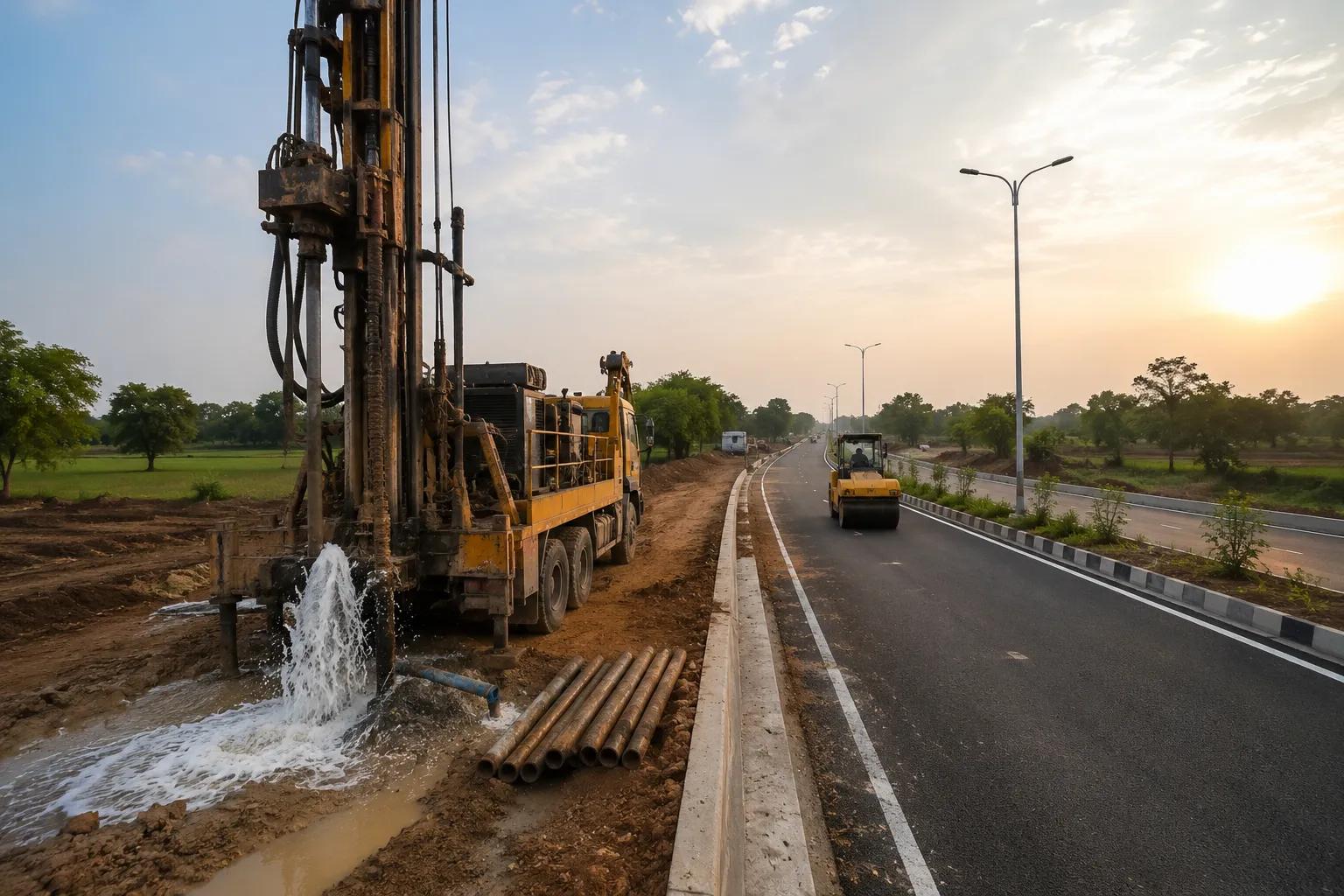
Every successful borewell drilling project begins long before the rig arrives on site — it begins with ensuring that the site is physically accessible. A borewell road, or borewell access road, is the planned pathway that allows heavy drilling machinery, water tankers, material transport vehicles, and survey teams to reach a drilling location safely and efficiently. Without proper borewell road infrastructure, even the best-planned groundwater project can face costly delays, equipment damage, and operational failures.
In India's rapidly growing industrial, highway, agricultural, and urban infrastructure landscape, the demand for professionally planned borewell road infrastructure has never been higher. Whether it is a highway road crossing borewell, an industrial groundwater supply project, or a government rural water scheme, the quality of borewell access road planning directly determines the success and cost efficiency of the entire drilling operation.
Bhoojal Survey brings over 15 years of hydrogeological expertise and infrastructure consultancy experience to deliver end-to-end borewell road planning and groundwater infrastructure solutions across India.
What is Borewell Road Infrastructure?
Quick Definition
A borewell road is a dedicated access route — either temporary or permanent — constructed or identified to enable safe movement of drilling machinery, supply vehicles, and survey equipment to and from a borewell drilling site. It is a critical component of groundwater infrastructure planning, especially in remote, industrial, or highway corridor locations.
Borewell road infrastructure encompasses route identification, terrain evaluation, ground stability assessment, and access road preparation. It forms the logistical backbone of any groundwater drilling project. In urban and semi-urban settings, borewell road crossing solutions are equally important — particularly when drilling operations must take place beneath or adjacent to existing roads, pipelines, or highway corridors.
A professionally designed borewell access road ensures that drilling rigs, which can weigh several tonnes, can be safely transported and positioned without damaging existing infrastructure or causing soil erosion at the site.
Why Borewell Road Planning is Important
Neglecting borewell road planning is one of the most common — and most expensive — mistakes in groundwater infrastructure development. Poor access road preparation leads to machinery getting stuck, project timelines getting extended, and overall project costs escalating significantly. Here is why structured borewell road planning is non-negotiable:
◆Safe drilling machine movement: Heavy drilling rigs require stable, load-bearing access routes. Without proper ground assessment, vehicles risk sinking into soft soil or causing road damage.
◆Uninterrupted equipment transportation: Fuel tankers, casing pipes, drilling chemicals, and water supply vehicles must reach the site without obstruction throughout the project duration.
◆Improved project efficiency: A well-planned borewell access road reduces idle time, minimises turnaround time for supply runs, and keeps the project on schedule.
◆Reduced operational delays: Weather, terrain changes, and unexpected obstacles are mitigated when site access is surveyed and prepared in advance.
◆Better site accessibility for maintenance: Post-drilling, access roads are essential for pump installation, borewell maintenance, and regular monitoring visits.
Site Survey for Borewell Road Planning
A thorough site survey is the foundation of effective borewell road planning. At Bhoojal Survey, our experts conduct a multi-stage site inspection process before any infrastructure recommendation is made:
◆Route identification & GPS mapping: Precise mapping of the shortest, safest, and most load-bearing route from the nearest motorable road to the drilling site.
◆Ground condition analysis: Soil type, bearing capacity, water table depth, and sub-surface stability are assessed to determine what road preparation is required.
◆Terrain evaluation: Slope gradients, flood-prone zones, rocky outcrops, and soft patches are identified and marked for engineering treatment.
◆Safety assessment: Proximity to utilities, power lines, pipelines, and existing structures is documented to ensure safe drilling machine movement.
◆Seasonal access planning: Monsoon and post-monsoon accessibility is evaluated for year-round project continuity.
Equipment and Technologies Used
Bhoojal Survey employs advanced scientific instruments and hydrogeological survey technologies to ensure accurate borewell road and groundwater infrastructure planning:
Hydrogeological Survey Instruments
Our field teams are equipped for conducting hydrogeological surveys using the SSRMPATS Instrument, GER DETECT, and PQWT at site for open well and borewell location identification. These advanced instruments enable sub-surface analysis, aquifer detection, and groundwater zone mapping with high precision — ensuring borewell sites are optimally located for both yield and road accessibility.
◆GPS & GIS mapping systems: For accurate route planning, terrain mapping, and digital site documentation.
◆Land survey instruments (Total Station, RTK GPS): For precise elevation and boundary measurement.
◆Terrain mapping & drone survey technology: Aerial imaging for large-scale borewell infrastructure site assessment.
◆Infrastructure planning software: CAD-based road layout design for borewell access route planning.
◆Soil testing equipment: For ground bearing capacity assessment along the proposed borewell road corridor.
Challenges in Borewell Road Development
Developing effective borewell road infrastructure in India presents several technical and logistical challenges that require experienced professional assessment:
◆Uneven and rocky terrain: Hilly or rocky areas require blasting, grading, or alternative route selection — all of which must be factored into pre-project planning.
◆Seasonal transportation difficulties: Monsoon flooding can render unprepared access routes impassable, stalling drilling operations at critical phases.
◆Soil stability issues: Expansive black cotton soil, loose sandy formations, and water-logged areas present significant ground stability challenges for heavy drilling equipment.
◆Remote site accessibility: Many groundwater projects are located in forests, agricultural fields, or tribal areas with limited or no existing road connectivity.
◆Utility conflict zones: Urban and peri-urban borewell projects must navigate underground utilities, buried cables, and existing pipeline networks along the access route.
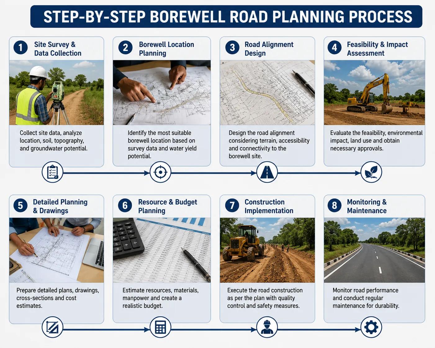
Step-by-Step Borewell Road Planning Process
Bhoojal Survey follows a structured, scientifically validated workflow for every borewell road planning assignment:
1. Site Inspection
Initial visit to the drilling location to assess existing accessibility, terrain type, and proximity to the nearest road network.
2. Terrain & Hydrogeological Analysis
Detailed ground condition study using GPS mapping, soil testing, and hydrogeological survey instruments.
3. Route Planning
Identification and mapping of the optimal borewell access road corridor based on terrain, load requirements, and distance.
4. Ground Stability Assessment
Laboratory and field testing of soil bearing capacity along the proposed access route.
5. Infrastructure Design
Preparation of access road design drawings including width, surface type, drainage provisions, and turning radius for drilling rigs.
6. Access Road Preparation Guidance
Technical recommendations for road surface preparation — gravel laying, compaction, culvert installation, or concrete pathways as required.
7. Equipment Transportation Planning
Logistics planning for rig mobilisation, fuel supply, casing pipe transport, and return movement post-drilling.
8. Final Site Development Report
Comprehensive technical report with maps, photographs, recommendations, and cost estimates for client review and project execution.
Benefits of Professional Borewell Road Survey Services Project Benefits Infrastructure Advantages
• Better project planning & execution
• Improved infrastructure safety standards
• Scientific, data-backed route decisions
• Reduced machinery breakdown risk
• Regulatory and environmental compliance
• Lower project cost overruns
• Long-term site accessibility & maintenance
How Bhoojal Survey Can Help You
When it comes to borewell road planning and groundwater infrastructure development in India, Bhoojal Survey stands apart as a trusted technical partner. Here is how our team adds measurable value to your project:
End-to-End Site Access Planning
From the first site visit to the final infrastructure report, our team handles every stage of borewell road planning — saving you time, money, and the risk of costly on-site surprises.
Advanced Hydrogeological Survey Integration
Unlike general civil survey firms, we combine borewell road planning with sub-surface groundwater investigation. This means the drilling location, the access route, and the infrastructure design are all optimised together — not in isolation.
Customised Solutions for Every Terrain
Whether your project is in the arid zones of Rajasthan, the black cotton soil belts of Madhya Pradesh, the hilly terrain of Himachal Pradesh, or the waterlogged deltaic areas of West Bengal — we design borewell road solutions specific to your ground conditions.
Fast Turnaround & Detailed Reporting
Our teams deliver comprehensive technical site reports with GPS-tagged photographs, route maps, soil test results, and infrastructure recommendations — typically within 5 to 7 working days of the site visit.
Pan-India Consultancy Coverage
Bhoojal Survey operates across all major states and Union Territories in India, with experienced field teams available for rapid deployment to industrial, highway, agricultural, and government project sites.
Compliance with National Standards
All our borewell road and groundwater infrastructure planning work is conducted in accordance with Central Ground Water Board (CGWB) guidelines, Ministry of Jal Shakti directives, and relevant BIS infrastructure standards — ensuring your project remains compliant and audit-ready.
Why Choose Bhoojal Survey for Borewell Road Infrastructure?
Bhoojal Survey is India's trusted hydrogeological and groundwater infrastructure consultancy, with a proven track record across industrial, agricultural, highway, and government projects. Our borewell road planning services are backed by science, delivered by experienced professionals, and customised to the specific demands of your project site.
◆ 15+ years of hydrogeological and borewell infrastructure consultancy experience across India.
◆ Advanced survey instruments including SSRMPATS, GER DETECT, and PQWT for sub-surface investigation.
◆ Dedicated borewell road survey teams with expertise in terrain analysis and access planning.
◆ Fast, accurate technical reporting with GPS mapping, photographs, and infrastructure recommendations.
◆ Pan-India project coverage — from metropolitan corridors to remote rural and tribal regions.
◆ Full compliance with CGWB, Ministry of Jal Shakti, and BIS infrastructure guidelines.
◆ Integrated groundwater survey + borewell road planning for holistic project efficiency.
Conclusion
Borewell road infrastructure is the often-overlooked foundation of every successful groundwater drilling project. Whether you are planning a large-scale industrial groundwater supply system, a highway borewell road crossing, or an agricultural irrigation project in rural India, the quality of your borewell access road planning will directly determine your project's efficiency, cost, and safety outcomes.
Professional borewell road survey services from Bhoojal Survey ensure that your drilling operations are supported by scientifically assessed, terrain-specific infrastructure — from the first equipment vehicle to the final commissioning visit.
■ Contact Bhoojal Survey Today Professional Borewell Road Planning &
Groundwater Infrastructure Consultancy Pan-India Services | Fast Turnaround | Scientific Site Assessment
Frequently Asked Questions — Borewell Road
Q1. What is a borewell road?
A borewell road is a dedicated access pathway — temporary or permanent — designed to allow drilling machinery, supply vehicles, and survey teams to safely reach a borewell drilling site. It includes route identification, ground preparation, and load-bearing infrastructure planning.
Q2. Why is road access important for borewell drilling?
Drilling rigs are heavy, specialised machines that require stable, accessible routes to reach the drilling site.
Without proper access, machinery can become stranded, project timelines are extended, and equipment damage risk increases significantly.
Q3. What surveys are required before borewell road construction?
A comprehensive site survey is required, covering GPS route mapping, soil bearing capacity testing, terrain elevation analysis, utility conflict identification, and hydrogeological ground condition assessment. Bhoojal Survey provides all of these as part of our borewell road planning service.
Q4. How is borewell road infrastructure planned in India?
Borewell road infrastructure planning in India involves site inspection, terrain mapping, ground stability analysis, route optimisation, infrastructure design, and access road preparation guidance — all aligned with CGWB and BIS standards.
Q5. What equipment is used in borewell site and road development?
Bhoojal Survey uses GPS and GIS mapping systems, total station survey instruments, SSRMPATS, GER DETECT, and PQWT hydrogeological instruments, terrain mapping software, and soil testing equipment for comprehensive borewell road and site assessment.
Q6. Can Bhoojal Survey plan borewell road access for highway projects?
Yes. Bhoojal Survey has extensive experience in highway and road corridor borewell access planning, including borewell road crossing solutions for infrastructure corridors across India.
Q7. How long does a borewell road survey take?
A standard borewell road site survey is typically completed within 1 to 3 days, with a comprehensive technical report delivered within 5 to 7 working days depending on project scope and site location.
Q8. Does Bhoojal Survey provide services across all states in India?
Yes. Bhoojal Survey offers pan-India borewell road planning and groundwater infrastructure consultancy services, covering all major states and project types — from urban commercial developments to remote agricultural and government water projects.