A Complete Guide for Water Resource Planning
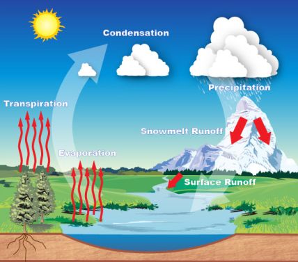
Runoff is one of the most fundamental concepts in hydrology. It refers to the flow of water — from rainfall, snowmelt, or irrigation — that moves across land surfaces and eventually reaches streams, rivers, or water bodies. Understanding what is runoff in hydrology is essential for flood prediction, watershed planning, reservoir design, and sustainable water resource management.
In the hydrological cycle, runoff acts as a critical link between precipitation and river discharge. For environmental consultants, watershed managers, civil engineers, and water planners, runoff analysis forms the scientific foundation of sound infrastructure and conservation decisions.
What is Runoff in Hydrology?
In simple terms, runoff in hydrology is the portion of precipitation that does not get absorbed into the ground or evaporate into the atmosphere but instead flows over the land surface into drainage channels, rivers, and reservoirs.
When rainfall intensity exceeds the infiltration capacity of soil, water accumulates on the surface and begins to move downhill. This movement — driven by gravity across a watershed or drainage basin — is called the runoff process. The rainfall-runoff relationship determines how much water from a storm event actually contributes to streamflow, which is a central question in hydrological investigation and flood analysis.
Types of Runoff in Hydrology
There are three primary types of runoff hydrologists study:
1. Surface Runoff Also called overland flow, surface runoff in hydrology occurs when rainfall exceeds the soil's absorption rate. It is the fastest type and strongly contributes to flash floods in urban and semi-arid regions across India.
2. Subsurface Runoff This involves water that infiltrates the topsoil but moves laterally through shallow soil layers before reaching a stream. It is slower than surface flow and plays a role in maintaining baseflow in rivers.
3. Channel Runoff Once water enters a stream or river channel, it becomes channel runoff. This is the measured discharge at gauging stations and forms the basis of river basin runoff studies and flood modelling.
4. Stormwater Runoff In urban areas, impervious surfaces — roads, rooftops, pavements — prevent infiltration and generate large volumes of stormwater runoff rapidly. Managing this is critical for urban drainage systems and flood control in Indian cities.
Factors Affecting Runoff
Several natural and human-induced factors control how much runoff is generated from a given rainfall event:
- Rainfall Intensity and Duration: Higher intensity storms generate greater rainfall excess runoff.
- Soil Type and Permeability: Sandy soils absorb more water; clay-heavy soils generate higher surface runoff.
- Land Slope: Steeper terrain accelerates flow, reducing infiltration time.
- Vegetation Cover: Dense vegetation slows runoff and promotes infiltration. Deforested watersheds show significantly higher runoff volumes.
- Urbanization: Expanding impervious cover in cities increases stormwater runoff and flood risk.
- Antecedent Moisture Conditions: Already saturated soils from prior rainfall generate more runoff from subsequent events.
At Bhoojal Survey, our field investigations include conducting hydrogeological surveys using SSRMPATS Instruments, GER DETECT, and PQWT at site for open well and borewell location identification. We combine these advanced hydrological and geophysical survey solutions with scientific watershed investigation and analysis to deliver accurate, field-verified runoff assessments.

Importance of Runoff Analysis in Water Resource Management
Understanding and quantifying runoff has direct practical applications:
- Flood Prediction and Control: Hydrological runoff modelling helps forecast peak discharge and prepare communities for flood events.
- Watershed Management: Accurate watershed runoff analysis guides soil conservation, reforestation, and check dam placement.
- Reservoir Planning: Engineers use runoff estimation methods to calculate storage requirements for dams and water supply reservoirs.
- Irrigation System Design: Agricultural water conservation projects depend on seasonal runoff data for canal and tank design.
- Environmental Protection: Monitoring runoff and infiltration ensures groundwater recharge zones are preserved in ecologically sensitive areas.
In India, river basin runoff studies are critical for the management of major systems including the Ganga, Godavari, Krishna, and Narmada basins under national water planning frameworks.
Why Choose Bhoojal Survey for Runoff and Watershed Analysis
Bhoojal Survey is a trusted professional hydrology consultancy in India offering end-to-end runoff assessment services, hydrological investigation, and water resource planning solutions.
Our services include:
- Scientific watershed investigation and drainage basin hydrology studies
- Hydrological runoff modelling and flood runoff analysis
- Stormwater runoff and urban drainage system assessments
- Groundwater and surface water resource evaluation
- Customized water resource management reports for government, infrastructure, and agricultural clients
- Pan-India survey and consultancy services with experienced field teams
We deliver reliable, field-verified, and scientifically rigorous hydrological solutions tailored to the specific needs of each project.
Conclusion
Runoff in hydrology is far more than moving water — it is a measurable, manageable, and scientifically critical component of the water cycle. From flood control to reservoir design and irrigation planning, accurate runoff analysis underpins every major water resource decision.
Whether you are managing a watershed, planning a flood mitigation project, or assessing stormwater drainage for urban infrastructure, professional runoff assessment is non-negotiable. Bhoojal Survey brings the expertise, technology, and field experience to deliver accurate hydrological investigation and watershed analysis solutions across India.
📞 Contact Bhoojal Survey today to discuss your hydrological investigation, runoff assessment, or water resource management requirements.
Frequently Asked Questions (FAQs)
Q1. What is runoff in hydrology? Runoff in hydrology is the water from rainfall or snowmelt that flows over land surfaces into rivers, streams, or water bodies after exceeding the soil's absorption capacity. It is a key component of the hydrological cycle and influences flood events, river discharge, and groundwater recharge.
Q2. What causes surface runoff? Surface runoff is caused when rainfall intensity exceeds the infiltration capacity of the soil. Other contributing factors include steep slopes, low vegetation cover, hard or compacted soils, and high levels of urbanization with impervious surfaces like roads and pavements.
Q3. How does runoff affect flooding in India? Excessive runoff from intense monsoon rainfall rapidly overloads rivers and drainage systems, leading to flooding. Poor watershed management, deforestation, and urban expansion significantly increase flood runoff risk across Indian cities and river basins.
Q4. Why is runoff analysis important for water resource management? Runoff analysis helps engineers and planners accurately estimate available water, design reservoirs and irrigation systems, plan stormwater drainage, and model flood events. It is essential for sustainable water resource management and infrastructure planning in India.
Q5. What is the difference between runoff and infiltration? Runoff is the water that flows over the land surface after rainfall, while infiltration is the process by which water is absorbed into the soil. The balance between runoff and infiltration determines how much water reaches rivers versus how much recharges groundwater aquifers.