Satellite Survey Solutions
Poor land planning decisions in infrastructure, mining, and urban development projects routinely stem from one source — inadequate spatial data at the planning stage. Roads aligned without accurate terrain information, industrial estates laid out without understanding drainage patterns, and government projects approved without proper land use analysis are all avoidable failures. Satellite survey solves this problem by delivering precise, comprehensive geospatial data across entire project zones — faster and more cost-effectively than any ground-based survey method.
Satellite survey uses earth observation satellites, remote sensing technologies, and GIS processing to capture and analyse spatial information about the land surface from space. It generates topographic maps, land use classifications, change detection analysis, drainage network maps, and environmental baseline data that are fundamental to infrastructure planning, environmental assessment, and resource management across India.
Bhoojal Survey provides professional satellite survey, GIS mapping, and remote sensing consultancy services across India — delivering geospatial intelligence for highway and railway projects, mining developments, smart city planning, watershed studies, and government infrastructure programmes.
What is Satellite Survey
A satellite survey is a systematic process of collecting, processing, and analysing geospatial data captured by earth-orbiting satellite sensors to produce maps, terrain models, land classification outputs, and spatial analysis products for planning, design, and decision-making purposes. Unlike traditional ground surveys that require physical access to every point of a project area, satellite survey acquires spatial data across entire regions simultaneously — enabling rapid, consistent coverage of large and remote project areas.
Modern satellite survey draws on a rich ecosystem of earth observation platforms — from India's own
ISRO Cartosat and Resourcesat series to international platforms including ESA Sentinel, NASA Landsat, and high-resolution commercial satellites. These satellites carry optical, multispectral, hyperspectral, and synthetic aperture radar (SAR) sensors that capture different aspects of land surface characteristics — visible imagery, vegetation health, surface moisture, thermal properties, and terrain elevation.
Key outputs delivered by a professional satellite survey programme include:
- High-resolution satellite imagery — visual and multispectral land surface mapping
- Digital Elevation Models (DEM) — continuous terrain height data across the project area
- Land use and land cover (LULC) maps — classified surface feature mapping
- Vegetation and NDVI analysis — crop health, forest cover, and land degradation assessment
- Change detection analysis — temporal comparison of land surface change over time
- Drainage network and watershed maps — hydrological basin delineation from terrain data
Why Satellite Survey is Important
India's infrastructure development pipeline — spanning highways, railways, industrial corridors, smart cities, and energy projects — demands spatial data at scales and speeds that traditional field survey methods cannot deliver economically. Satellite survey bridges this gap by providing consistent, current, and comprehensive geospatial coverage that supports every stage of the project lifecycle from feasibility to monitoring.
- Accurate Land and Terrain Mapping: Satellite survey delivers terrain and land surface data at spatial resolutions ranging from metres to sub-metre, enabling accurate contour mapping, slope analysis, and land feature identification across project corridors of any length or area.
- Infrastructure Planning Support: Highway alignments, railway routes, pipeline corridors, power transmission lines, and industrial estate layouts are all optimised using satellite survey data to avoid terrain hazards, minimise earthworks, and reduce environmental impact.
- Environmental and Watershed Analysis: Satellite imagery and DEM data support
Environmental Impact Assessment (EIA), watershed delineation, flood risk mapping, forest cover analysis, and biodiversity baseline studies required for environmental clearances.
- Urban Planning and Smart City Development: City masterplans, peripheral development layouts, and smart city infrastructure programmes use satellite survey data to map existing built-up areas, identify developable land, assess drainage capacity, and plan utility networks.
- Reducing Project Planning Risks: Satellite survey identifies terrain constraints, drainage hazards, land use conflicts, and sensitive environmental features at the planning stage — preventing costly design changes and approval delays during project execution.
Methods Used in Satellite Survey
Bhoojal Survey combines multiple satellite remote sensing and GIS processing methodologies to deliver satellite survey products matched to project-specific accuracy, coverage, and application requirements across India.
- Remote Sensing Survey:
Multi-spectral and panchromatic satellite imagery is processed for land use classification, vegetation analysis, water body mapping, built-up area identification, and surface feature extraction. Radar satellite data (SAR) provides terrain and surface information through cloud cover — essential for reliable data acquisition during India's monsoon season when optical satellites are frequently obscured.
- GIS-Based Satellite Mapping:
Processed satellite data layers are integrated in GIS software with project-specific spatial data — topographic maps, cadastral boundaries, infrastructure networks, and environmental data — to produce integrated project planning maps and spatial analysis outputs tailored to engineering and regulatory requirements.
- Satellite Imagery Analysis:
High-resolution satellite images are interpreted by trained geospatial analysts to identify geological features, drainage anomalies, land use patterns, infrastructure corridors, and environmental sensitivities relevant to the project's planning and design decisions.
- Terrain and Landform Interpretation:
DEM data derived from satellite stereo-pair processing or radar interferometry is analysed to classify terrain landforms — ridges, valleys, plains, dissected plateau, and flood-prone lowlands — providing spatial context for site selection and infrastructure routing decisions.
- Geospatial Data Processing:
Raw satellite data is processed through radiometric correction, orthorectification, and geometric registration to produce analysis-ready map products in standard GIS formats. Change detection analysis compares satellite images from different dates to monitor land use change, construction progress, environmental impact, or post-flood assessment.
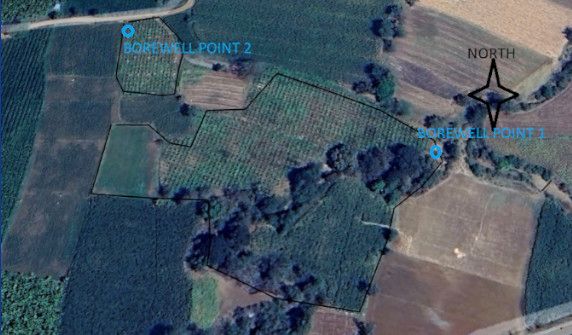
Bhoojal Survey conducts hydrogeological survey using SSRMPATS Instrument, GER DETECT, and PQWT at site for open well / borewell location — delivering advanced satellite and geospatial survey solutions with scientific land investigation and spatial analysis.
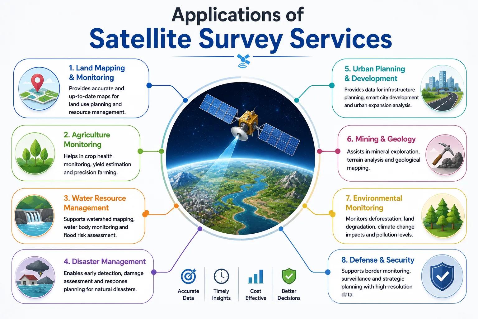
Applications of Satellite Survey Services
Professional satellite survey services support a broad range of infrastructure, environmental, industrial, and government project sectors in India. Bhoojal Survey has delivered GIS mapping and remote sensing analysis for the following application areas:
• National & State Highway Alignment Planning
• Watershed Management & Flood Risk Studies
• Railway Route Survey & Corridor Mapping
• Environmental Baseline & EIA Surveys
• Open-Cast Mining Area Survey & Monitoring
• Solar & Wind Farm Site Assessment
• Smart City Masterplan & Urban Development
• Government Land Records & Revenue Mapping
For each application, Bhoojal Survey delivers a complete satellite survey package — from satellite data acquisition and GIS processing through to final map products, spatial analysis reports, and technical documentation formatted for engineering design, environmental clearance, and project approval submissions.
Why Choose Bhoojal Survey for Satellite Survey Services
Bhoojal Survey is a professional geospatial consultancy providing satellite survey, GIS mapping, and remote sensing analysis services across India. Our team of experienced GIS analysts, remote sensing specialists, and geospatial engineers delivers satellite survey products that are accurate, timely, and directly applicable to your project's planning and design requirements.
- Experienced Geospatial and Survey Experts: Our team brings hands-on experience in satellite survey and GIS mapping for highway, mining, watershed, urban development, and environmental projects across India's diverse terrain and land use environments.
- Advanced Satellite Mapping Technologies: We work with India's ISRO Cartosat and Resourcesat data alongside international platforms including Sentinel, Landsat, and high-resolution commercial satellites — selecting the optimal data source for each project's accuracy and coverage requirements.
- Accurate Terrain and Land Analysis: Every satellite survey project delivers validated, analysis-ready geospatial products — from orthorectified imagery to classified LULC maps and DEM-derived terrain analysis — verified for spatial accuracy before delivery.
- Fast Reporting and Technical Consultancy: Satellite survey products are delivered efficiently without the extended mobilisation timelines of ground survey methods, enabling project teams to proceed with planning and design activities without spatial data delays.
- Pan-India Geospatial Survey Services: Our satellite survey capabilities cover all Indian terrain environments — Himalayan mountains, Indo-Gangetic plains, Deccan plateau, coastal zones, and desert regions — without seasonal or access limitations.
- Customised Geospatial Investigation Solutions: We design satellite survey programmes precisely matched to your project area, required deliverable format, accuracy specification, and application — from a small industrial site assessment to a 500-kilometre highway corridor study.
Conclusion
As India's development ambitions grow and project scales expand, the demand for accurate, rapid, and cost-effective spatial data grows with them. Satellite survey is no longer a specialist tool for large government projects — it is a practical, accessible technology that delivers geospatial intelligence for projects of all sizes, from single-site industrial developments to multi-state infrastructure corridors.
Projects planned with satellite survey data make better alignment decisions, identify environmental constraints earlier, design more effective drainage systems, and arrive at construction-ready designs with fewer costly revisions. Bhoojal Survey's professional satellite survey and GIS mapping services give your project team the spatial foundation it needs to plan with confidence and build without surprises.
Contact Bhoojal Survey for professional satellite survey and GIS mapping services across India.
Frequently Asked Questions (FAQ)
1. What is satellite survey and how is it used in infrastructure projects?
Satellite survey is the systematic collection, processing, and analysis of spatial data captured by earth observation satellites to produce maps, terrain models, land classification products, and geospatial analysis outputs. In infrastructure projects, satellite survey is used for highway and railway alignment planning, site selection, terrain analysis, environmental baseline mapping, land use assessment, and change detection monitoring. It delivers comprehensive spatial coverage of large project areas rapidly and cost-effectively compared to traditional ground survey methods.
2. How does remote sensing work in satellite survey?
Remote sensing works by recording electromagnetic radiation reflected or emitted from the earth's surface using sensors mounted on satellites. Optical sensors capture visible and near-infrared reflectance from land features — enabling land use classification, vegetation mapping, and water body identification. SAR (Synthetic Aperture Radar) sensors emit microwave pulses and record the reflected signal to capture terrain elevation and surface texture information through cloud cover. The recorded data is processed to extract geospatial information about the land surface for mapping and analysis applications.
3. How accurate is satellite mapping for engineering and infrastructure projects?
Satellite mapping accuracy depends on the satellite platform and processing methodology. Freely available data such as Sentinel-2 provides 10-metre spatial resolution for land cover mapping. High-resolution commercial satellites achieve sub-metre spatial resolution for detailed feature mapping. DEM accuracy for terrain modelling ranges from approximately 5-10 metres vertical for freely available DEMs to 1-3 metres for high-resolution processed products. For projects requiring higher accuracy, satellite data is supplemented with Ground Control Points (GCPs) and field verification. Bhoojal Survey recommends the appropriate data source for each project's accuracy requirements.
4. What GIS technology is used in satellite survey services?
GIS (Geographic Information Systems) is the core technology used to process, integrate, analyse, and present satellite survey data. GIS software handles satellite image processing, terrain analysis, land use classification, spatial overlay analysis, and map production. It integrates satellite-derived data with project-specific spatial layers — cadastral boundaries, infrastructure networks, environmental data — to produce integrated planning maps. Final products are delivered in standard GIS formats (GeoTIFF, Shapefile, GeoPackage) compatible with engineering design and project management software.
5. What industries use professional satellite survey services in India?
Satellite survey services are used across highway and railway infrastructure development, open-cast mining and quarry operations, smart city and urban planning, solar and wind energy project development, pipeline and transmission corridor planning, watershed management and flood risk studies, environmental impact assessment, government land records and revenue survey, forestry and agricultural monitoring, and defence and strategic mapping. Any sector requiring accurate, current, and comprehensive spatial data for planning, design, monitoring, or regulatory compliance benefits from professional satellite survey services.