Satellite survey is transforming how India's infrastructure, mining, and environmental sectors plan and execute large-scale projects. Using satellite remote sensing, GIS satellite mapping, and earth observation data, modern survey professionals can capture precise geospatial intelligence across vast areas — faster and more cost-effectively than ever before.
Whether you are planning a solar plant layout, designing a substation earthing system, siting a telecom tower, or scoping a highway alignment, satellite-based land survey gives you the spatial accuracy and terrain intelligence needed to make critical engineering decisions with confidence.
At Bhoojal Survey, we integrate professional satellite survey services with our on-ground hydrogeological, geophysical, and infrastructure investigation expertise. This combination allows us to deliver comprehensive geospatial mapping and sub-surface analysis solutions customised to your project's scale and technical requirements.
What is a Satellite Survey?
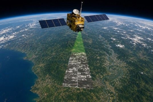
A satellite survey is a scientific method of collecting spatial data about the Earth's surface using sensors mounted on orbiting satellites. These sensors capture high-resolution imagery and multispectral data across large geographic areas, which is then processed using advanced GIS mapping software to extract actionable geospatial intelligence.
Unlike traditional land surveys that require physical access to every point, satellite remote sensing enables data collection over inaccessible terrain, dense forest zones, large industrial sites, and remote geographic regions — without deploying large field crews.
In engineering and infrastructure planning, satellite data mapping combines with Geographic Information System (GIS) platforms to produce detailed terrain maps, land use classification, drainage models, and geological feature extraction. This makes satellite survey the foundation of modern geospatial analysis for complex infrastructure and environmental projects.
Earth Observation DataGIS Satellite MappingRemote Sensing SurveyGeospatial Data Processing
al imagery from polar-orbiting and geostaIntegration of satellite data with GIS for spatiaScientific extraction of land, geological and environmental data from satellite sensors.ionary satellites. analysis and planning.Advanced spatial analysis, classification and visualizati
Why Satellite Surveys are Important
In India's rapidly expanding infrastructure landscape — from renewable energy parks to highway corridors and smart city projects — accurate, timely spatial data is not optional; it is operationally essential. Traditional ground surveys are slow, expensive for large areas, and logistically constrained in challenging terrain.
Satellite-based surveys eliminate most of these barriers.
- Capture detailed land and terrain data across hundreds of square kilometres in a single data collectioncycle
- Generate accurate topographic maps, drainage networks, and land use classification for infrastructureplanning
- Monitor environmental changes, vegetation cover, and water body shifts over time using satellite imageryanalysis
- Significantly reduce survey mobilisation time and project planning costs compared to conventionalmethods
- Provide reliable baseline data for Environmental Impact Assessments (EIA) and regulatory compliancereports
- Enable pre-feasibility analysis without requiring physical site access in early project phases
Applications of Satellite Survey
Satellite-based geospatial mapping serves a diverse range of professional sectors across India.
Solar & Renewable Energy
Site suitability mapping, shadow analysis, and terrain profiling for solar plant layout and EPC planning.
Infrastructure & Highways
Corridor alignment, land acquisition mapping, and terrain analysis for road and rail infrastructure.
Mining & Geological Exploration
Lithological mapping, structural geology interpretation, and mineral potential zone identification.
Environmental Monitoring
Forest cover change detection, land degradation assessment, and ecological impact mapping.
Water Resource Management
Watershed delineation, groundwater potential zone mapping, and flood risk assessment.
Urban Planning & Smart Cities
Land use land cover mapping, urban sprawl analysis, and
infrastructure gap identification.
Telecom & Substation Projects
Tower site selection, network coverage planning, and terrain clearance analysis.
Agriculture & Irrigation
Crop health monitoring, canal command area mapping, and soil moisture analysis.
Methods Used in Satellite Survey
Remote Sensing Survey
Remote sensing is the scientific backbone of satellite survey operations. Satellites equipped with passive optical sensors and active radar sensors (including SAR — Synthetic Aperture Radar) collect electromagnetic radiation reflected or emitted from the Earth's surface. These readings, spanning visible, near-infrared, and thermal wavelength bands, are processed to extract specific land features, geological formations, moisture content, vegetation indices, and surface temperature patterns.
For infrastructure and geotechnical applications, remote sensing survey data provides valuable pre-investigation intelligence — particularly for identifying drainage patterns, fractured rock zones, and potential groundwater recharge areas — before field teams are deployed.
GIS-Based Satellite Mapping
Geographic Information System (GIS) platforms transform raw satellite imagery into layered, queryable spatial maps. GIS satellite mapping allows engineers and planners to overlay multiple data themes — terrain elevation, soil type, land use, drainage, geology — onto a single integrated map environment. This spatial analysis layer supports precise infrastructure routing, site selection, and environmental impact assessment.
At Bhoojal Survey, GIS mapping is used to deliver accurate satellite-based land mapping services that inform everything from borewell site selection to substation earthing design and solar plant feasibility.
Satellite Image Analysis
High-resolution satellite imagery analysis enables the identification of surface features at sub-metre resolution. Image classification algorithms, spectral indices (such as NDVI for vegetation and MNDWI for water bodies), and change detection analysis provide detailed land feature maps. For geological and geophysical surveys, satellite terrain mapping reveals lineaments, fault structures, and lithological boundaries that guide ground investigation strategies.
Equipment and Technologies Used
• Satellite Imagery Systems
• GIS Mapping Software
• SAR Remote Sensing
Technology
• DGPS / GPS Mapping Tools
• Geospatial Data Processing
Software
• Survey Data Analysis Software
• Field Verification Equipment
On-Site Field Integration: Our satellite survey services are complemented by ground-truth hydrogeological investigations using advanced instruments including the SSRMPATS Instrument, GER DETECT, and PQWT — deployed on-site for precise open well and borewell location identification. This integration of satellite data interpretation with field-verified geophysical investigation ensures the highest level of accuracy in our survey outputs.
Factors Affecting Satellite Survey Accuracy
- Satellite resolution: Spatial resolution (pixel size) determines the level of ground feature detail captured.
Sub-metre commercial satellites deliver engineering-grade accuracy.
- Weather and atmospheric conditions: Cloud cover affects optical imagery acquisition. SAR satellites operate through cloud cover and rainfall, making them suitable for India's monsoon-affected zones.
- Image processing techniques: Atmospheric correction, geometric rectification, and radiometric calibration directly influence classification accuracy.
- Terrain complexity: Hilly and forested terrain introduces shadow effects and canopy obstruction that require specialist processing protocols.
- Ground truthing and field validation: Integration of satellite outputs with on-site geophysical measurements ensures data reliability and map accuracy.
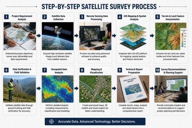
Step-by-Step Satellite Survey Process
- Project requirement analysis — understanding site extent, data resolution needs, and project deliverables
- Satellite data acquisition — selecting and procuring appropriate satellite imagery based on resolution,cloud cover criteria, and data vintage
- Remote sensing data pre-processing — atmospheric correction, geometric rectification, and imageenhancement
- GIS mapping and spatial analysis — layer creation, feature extraction, and thematic mapping using GISplatforms
- Terrain and land feature interpretation — identifying topographic gradients, drainage networks, geologicallineaments, and land use classes
- Geospatial data analysis — applying spectral indices, change detection, and classification algorithms
- Field validation and ground truthing — deploying field teams with GPS and geophysical instruments toverify satellite-derived findings
- Data integration — merging satellite outputs with geophysical and hydrogeological survey data for acomplete site picture
- Mapping and visualisation — producing final map deliverables in GIS and printable formats
- Technical report preparation — compiling findings, interpretations, and engineering recommendations instructured project reports
Benefits of Professional Satellite Survey Services
- Large-area coverage with consistent spatial accuracy across entire project zones
- Dramatically faster data acquisition compared to conventional ground survey teams
- Reduced survey mobilisation costs, especially for remote, difficult-access, or large-scale project sites
- Repeatable multi-temporal monitoring — compare site conditions over months or years
- Structured, technically documented outputs suitable for project planning, regulatory submissions, and EIAreports
- Seamless integration with on-ground geophysical investigation for full-spectrum site intelligence
Why Choose Bhoojal Survey for Satellite Survey Services
We combine geospatial technology with deep field expertise to deliver survey solutions that infrastructure, mining, and energy projects across India can rely on.
Experienced Geospatial Team
Qualified surveyors and GIS analysts with demonstrated experience across infrastructure, mining, and environmental projects in India.
Advanced Mapping Technologies
High-resolution satellite imagery, SAR data, and professional GIS platforms for precise satellite terrain mapping.
Accurate Technical Reports
Professionally structured survey reports with clear data interpretation, map deliverables, and engineering recommendations.
Pan-India Coverage
Satellite survey and geospatial mapping services delivered across all states and union territories of India.
Customised Geospatial Solutions
Survey scope and deliverables tailored to the specific requirements of your project — from single-site to multi-region corridor mapping.
Integrated Field + Satellite Approach
Unique combination of satellite data analysis and on-ground geophysical investigation for validated, reliable survey outputs.
How Bhoojal Survey Can Help You
Bhoojal Survey is a professional survey consultancy specialising in the complete integration of satellite-based geospatial analysis with field-verified hydrogeological, geophysical, and infrastructure investigations. Our work supports some of India's most demanding infrastructure and energy projects.
If you are an electrical contractor selecting an optimal earthing system site, an EPC company planning a solar plant layout, or a mining company needing geological feature mapping — Bhoojal Survey delivers the data clarity and technical documentation you need to move your project forward with confidence.
Our satellite survey services include remote sensing data acquisition, GIS-based land analysis, terrain mapping, land use classification, groundwater potential zone mapping, and full technical report preparation. We cover substations, solar farms, airports, telecom towers, mining leases, industrial sites, and government infrastructure projects across India.
We do not just deliver maps — we deliver geospatial intelligence that directly supports your engineering decisions and project execution planning.
Ready to get accurate satellite survey and geospatial mapping data for your project? Contact Bhoojal Survey today for a professional consultation.
Conclusion
Satellite survey technology has fundamentally changed the way infrastructure, mining, and environmental professionals collect spatial data and make planning decisions. The combination of high-resolution earth observation imagery, GIS satellite mapping, and advanced geospatial data analysis delivers survey intelligence that traditional methods simply cannot match at scale.
For project owners, engineers, and contractors working on India's next generation of industrial and infrastructure developments, investing in professional satellite survey services from a technically qualified consultancy is not just a competitive advantage — it is a project risk management essential.
Bhoojal Survey brings together satellite remote sensing expertise, GIS-based geospatial analysis, and field-verified hydrogeological investigation to provide comprehensive, reliable, and commercially actionable survey solutions. From initial feasibility to detailed site investigation, we are your trusted geospatial partner across India.
Frequently Asked Questions
Q: What is a satellite survey?
A satellite survey is the process of collecting geospatial data about the Earth's surface using sensors onboard orbiting satellites. The data is processed using GIS and remote sensing tools to produce maps, terrain models, and spatial analysis outputs used in infrastructure, environmental, and geological projects.
Q: How does satellite survey work?
Satellites equipped with optical and radar sensors capture multispectral imagery of the Earth's surface. This raw data is downloaded to ground stations, pre-processed for atmospheric and geometric corrections, and then analysed using GIS software to extract terrain features, land use classification, geological patterns, and other spatial information relevant to the project.
Q: What industries use satellite surveys in India?
Satellite surveys are widely used across solar energy, mining, infrastructure development, telecom, agriculture, urban planning, disaster management, environmental monitoring, and hydrogeological investigation sectors. EPC contractors, government agencies, and private infrastructure developers are among the primary users.
Q: Is satellite survey accurate for land mapping?
Yes. Modern commercial satellites offer sub-metre spatial resolution, enabling engineering-grade accuracy for land mapping. When satellite data is combined with GPS ground control points and field validation, the resulting maps meet accuracy standards required for infrastructure planning, EIA reports, and regulatory submissions.
Q: What is the difference between satellite survey and traditional survey?
Traditional surveys require physical measurement at every point, making them slow and expensive over large areas. Satellite surveys collect spatial data remotely across vast regions in a single acquisition cycle, significantly reducing time and cost. The best approach combines both methods for ground-truthed accuracy.
Q: How long does a satellite survey take?
Data acquisition for a large site can be completed within days. Processing, GIS analysis, and report preparation typically take one to three weeks depending on project complexity. Bhoojal Survey provides project-specific timelines during initial consultation.
Q: Can satellite survey identify groundwater potential zones?
Yes. Satellite-based geological and lineament mapping can identify structural features, fracture zones, and drainage convergence areas that are indicators of groundwater potential. At Bhoojal Survey, this is further validated through on-site hydrogeological investigation using geophysical instruments such as
SSRMPATS, GER DETECT, and PQWT.
Q: What deliverables does Bhoojal Survey provide?
Deliverables include processed satellite imagery, GIS-based thematic maps (terrain, land use, geology, drainage), geospatial data layers in standard formats, and a comprehensive technical report with interpretation findings, recommendations, and project planning support documentation.