Regional Hydrological Conditions
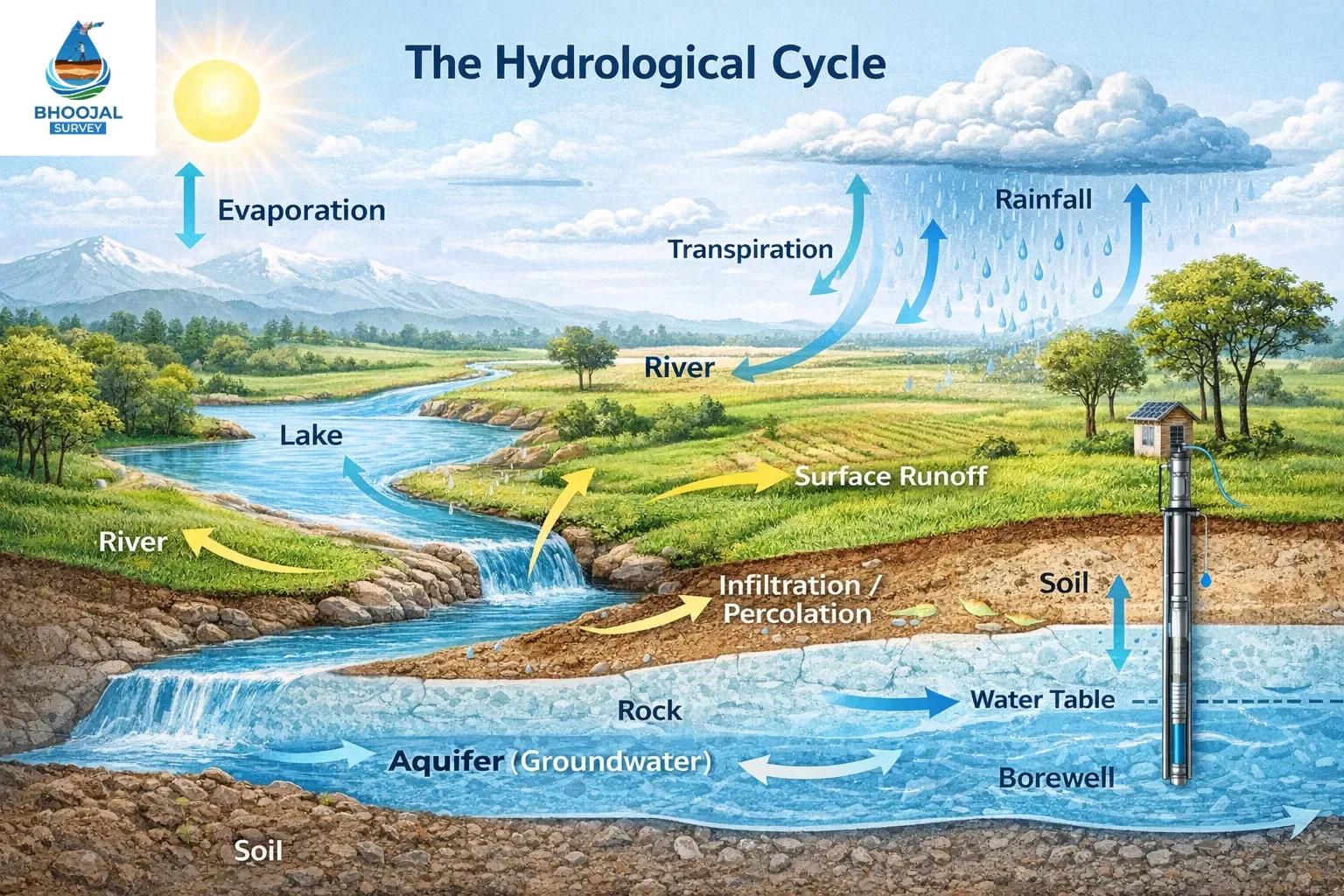
Regional hydrological conditions refer to the collective state of water systems within a geographic area — encompassing groundwater levels, river flows, rainfall distribution, wetlands, and watershed health. When these systems remain in balance, they support agriculture, ecosystems, urban water supply, and climate resilience. However, across India and globally, what has seriously affected the regional hydrological conditions is a combination of rapid human activity and accelerating climate change. Understanding these disruptions is essential for water resource management, environmental planning, and sustainable development.
What Are Regional Hydrological Conditions?
A regional hydrological system is an interconnected network of surface water, groundwater aquifers, precipitation patterns, and land-based water flows. Its key components include:
1. Groundwater recharge zones and aquifer storage
2. River and stream flow dynamics
3. Rainfall variability and seasonal distribution
4. Watershed catchment areas and drainage patterns
5. Wetlands, lakes, and riparian ecosystems
Disruption to any one component creates a hydrological imbalance that cascades across the entire system — impacting water availability, flood frequency, and environmental water stress across communities and industries.
Factors That Have Seriously Affected Regional Hydrological Conditions
Climate Change: Shifting monsoon patterns, rising temperatures, and erratic rainfall variability have fundamentally altered hydrological cycles. Extended dry spells reduce groundwater recharge, while intense short-duration rainfall triggers flash floods — both indicators of deep hydrological condition disruption across Indian river basins.
Deforestation & Watershed Degradation: Forest cover regulates the water cycle by promoting infiltration and reducing runoff. Large-scale deforestation has led to severe watershed degradation, reducing groundwater recharge rates and increasing surface erosion. Degraded watersheds are among the most critical drivers of regional hydrological changes across peninsular India.
Rapid Urbanisation: The expansion of impervious surfaces — roads, buildings, and concrete infrastructure — blocks natural water infiltration. Urbanization and hydrology are directly linked: cities increase surface runoff, overwhelm drainage systems, and accelerate groundwater depletion in peri-urban zones.
Excessive Groundwater Extraction: Over-extraction for agriculture, industry, and domestic use is one of the foremost causes of groundwater depletion in India. With millions of borewells drawing water faster than natural recharge allows, aquifer levels have dropped critically in states such as Punjab, Rajasthan, and Maharashtra.
River Pollution & Industrial Development: Untreated industrial effluents, municipal waste, and agricultural runoff have severely degraded river water quality, disrupting aquatic ecosystems and reducing usable water resources. Industrial development near river corridors causes hydrological system disturbances that take decades to reverse.
Irregular Rainfall Patterns: Shortened monsoon windows, unequal spatial distribution, and increasing rainfall variability have disrupted the natural recharge calendar of aquifers — amplifying both flood and drought conditions across vulnerable basins.
Impact of Hydrological Changes on Environment and Water Resources
The consequences of disrupted regional hydrological conditions extend far beyond water availability:
1. Groundwater depletion reducing drinking water access in rural and urban areas
2. Increased frequency of floods and drought conditions in the same basin
3. Loss of ecosystem water balance in wetlands and riparian habitats
4. Reduced agricultural productivity due to unreliable irrigation water
5. Environmental water stress affecting livestock, fisheries, and biodiversity
6. Accelerated land subsidence in over-extracted groundwater zones
Addressing these impacts requires advanced hydrological and groundwater survey solutions that combine field investigation with modern geophysical technologies. Bhoojal Survey delivers scientific environmental investigation and analysis by conducting hydrogeological surveys using SSRMPATS Instrument, GER DETECT, and PQWT at site for open well / borewell location — ensuring precise identification of viable groundwater zones even in complex geological formations.
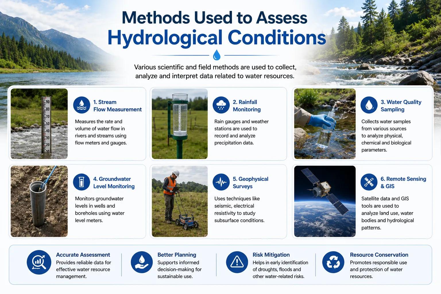
Methods Used to Assess Hydrological Conditions
Accurate hydrological condition analysis requires a multi-disciplinary approach. Professional assessment methods include:
- Hydrological Investigation: Field surveys mapping surface and subsurface water flows, recharge zones, and aquifer characteristics.
- Watershed Analysis: Delineation of catchment boundaries, runoff estimation, and land-use impact assessment for watershed management planning.
- GIS & Satellite Mapping: Remote sensing and geographic information systems identify land use change impacts, drainage alterations, and hydrological stress zones.
- Groundwater Recharge Assessment: Quantifying recharge potential through water table monitoring, tracer studies, and geophysical profiling.
- Environmental Monitoring: Continuous tracking of rainfall, streamflow, and water quality parameters to detect early signs of hydrological imbalance.
Combining these techniques provides a comprehensive scientific hydrological assessment that guides evidence-based water resource management and environmental planning decisions.
Why Choose Bhoojal Survey?
Bhoojal Survey is a professional hydrology consultancy in India with a proven track record in hydrological investigation, groundwater recharge analysis, watershed management consultancy, and environmental water analysis. Here is why clients across India trust us:
1. Experienced hydrologists and environmental consultants with field-proven expertise
2. Advanced geophysical instruments including SSRMPATS, GER DETECT, and PQWT for precise borewell location
3. Comprehensive scientific groundwater analysis from aquifer mapping to recharge modelling
4. Detailed professional reports aligned with CGWB, CWC, and Ministry of Jal Shakti guidelines
5. Pan-India environmental groundwater investigation services across all geological terrains
6. Customised hydrological solutions for agriculture, infrastructure, urban planning, and government projects
Conclusion
What has seriously affected the regional hydrological conditions is not a single factor but a convergence of climate change, deforestation, unplanned urbanisation, over-extraction of groundwater, and industrial pressures acting simultaneously on fragile water systems. Left unaddressed, these forces deepen water scarcity, amplify flood and drought risks, and compromise long-term water security for millions.
Scientific hydrological investigation, grounded in accurate data and modern geophysical methods, is the first step toward restoring balance. Bhoojal Survey brings the expertise, technology, and experience needed to diagnose hydrological stress and deliver actionable solutions — from groundwater survey to watershed management consultancy.
Frequently Asked Questions (FAQs)
Q1. What has seriously affected the regional hydrological conditions in India?
A combination of climate change, deforestation, rapid urbanisation, excessive groundwater extraction, and irregular rainfall has seriously affected the regional hydrological conditions across India. These factors reduce groundwater recharge, alter river flows, and create severe water resource degradation in both rural and urban areas.
Q2. How does climate change impact regional hydrology?
Climate change alters rainfall variability, intensifies extreme weather events, and disrupts seasonal recharge patterns. In India, shifting monsoons and rising temperatures have significantly changed the water balance of major river basins, increasing both flood and drought risks.
Q3. Why is groundwater depletion increasing in India?
Groundwater depletion in India is primarily driven by over-extraction for irrigation, industrial use, and drinking water supply — far exceeding natural recharge rates. Reduced forest cover, concretisation of recharge zones, and poor watershed management have further accelerated aquifer decline.
Q4. What causes hydrological imbalance in urban areas?
Urbanisation replaces permeable land with impervious surfaces, blocking groundwater recharge. Unplanned drainage, sewage discharge into water bodies, and removal of natural wetlands disrupt the ecosystem water balance — creating waterlogging during rains and severe water stress in dry seasons.
Q5. How can regional hydrological conditions be improved?
Improvement requires a scientific approach: professional hydrological investigation to map stress zones, watershed restoration to enhance recharge, regulated groundwater extraction, afforestation, and continuous environmental monitoring. Expert hydrology consultancy services, such as those offered by Bhoojal Survey, provide the data and strategy needed for sustainable hydrological recovery.