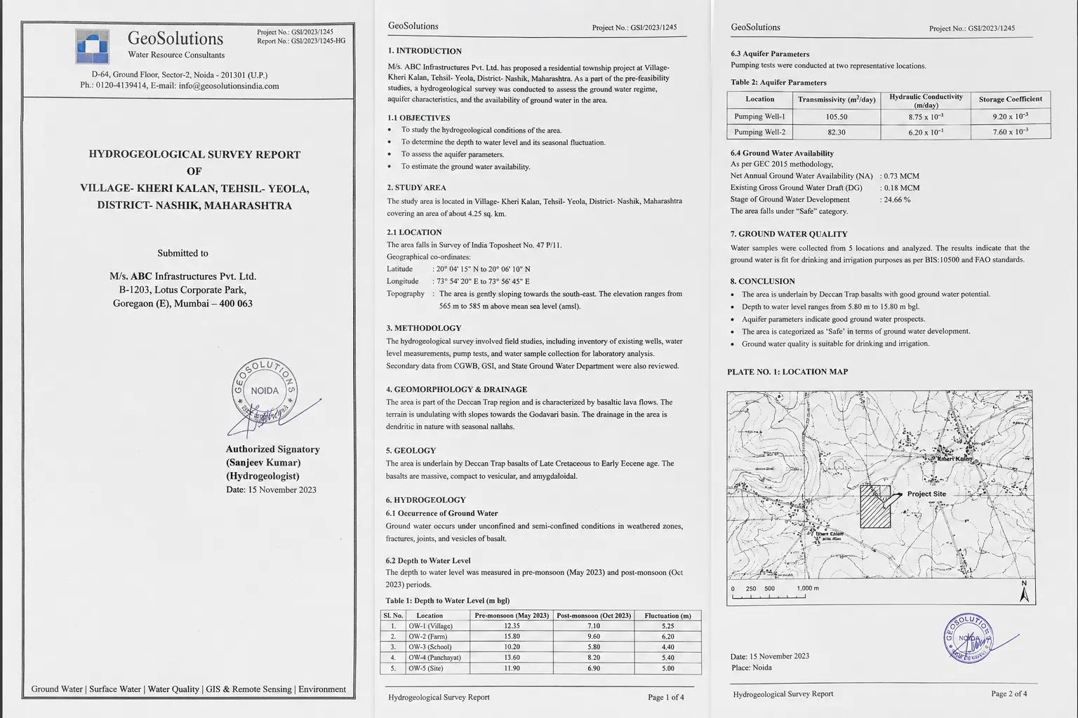
Hydrogeological Survey Report:
Groundwater is invisible — but its assessment cannot be guesswork. Before any borewell is drilled, any industrial unit draws water, or any infrastructure project breaks ground near a water-sensitive zone, a scientifically prepared Hydrogeological Survey Report must guide the decision.
This document is the professional record of what lies beneath — the geology, the aquifers, the water quality, and the long-term sustainability of groundwater at a given site. For project developers, government agencies, mining companies, and agricultural planners across India, this report is both a technical necessity and a regulatory requirement that determines project viability.
What is a Hydrogeological Survey Report?
A Hydrogeological Survey Report is a structured technical document prepared by experienced hydrogeologists after rigorous field investigation, geophysical testing, and scientific data analysis of a site's subsurface groundwater system.
It goes far beyond simply locating water. The report evaluates aquifer type and depth, estimates sustainable groundwater yield, assesses seasonal fluctuations, analyses water quality for intended use, and provides clear, actionable recommendations for groundwater development or conservation.
In practical terms, it answers the three questions every groundwater-dependent project needs answered: Is water available? How much can be sustainably extracted? And is it suitable for the intended purpose?
What Does a Hydrogeological Survey Report Contain?
A thorough groundwater survey report is built from multiple layers of field and analytical data:
- Site Description and Land Use: Location coordinates, topography, land use patterns, and proximity to existing water sources or ecologically sensitive areas.
- Subsurface Geology: Rock type identification, soil profiles, geological structures, fault lines, and formation depth — all critical to understanding aquifer behaviour.
- Aquifer Mapping and Characteristics: Classification of aquifer type — confined, unconfined, or fractured — along with thickness, hydraulic properties, and recharge-discharge dynamics.
- Groundwater Depth and Yield Estimates: Pre-monsoon and post-monsoon water table data, estimated borewell yield, and seasonal variability analysis.
- Water Quality Assessment: Physical, chemical, and biological water quality parameters tested against BIS standards for drinking, irrigation, or industrial application.
- Recharge Zone Identification: Mapping of natural recharge areas and evaluation of artificial groundwater recharge feasibility for long-term sustainability.
- Technical Recommendations: Site-specific borewell siting, depth targets, casing design guidance, and water management suggestions.
How is a Hydrogeological Survey Report Prepared?
The quality of any hydrogeological investigation report depends entirely on the methods used in the field and the expertise applied in analysis:
Geological Field Mapping: On-site geological reconnaissance identifies rock outcrops, soil types, natural drainage features, and surface indicators of subsurface water potential.
Geophysical Survey — Electrical Resistivity Method: Resistivity profiling generates subsurface cross-sections that reveal water-bearing zones, lithological boundaries, and aquifer depth without a single drill hole.
Remote Sensing and GIS Analysis: Satellite imagery and GIS-based lineament mapping identify fracture zones, drainage density, and recharge corridors that direct the investigation toward high-potential groundwater targets.
Pumping and Yield Tests: Field pump tests on existing wells provide aquifer transmissivity and storativity data essential for reliable yield estimation.
At Bhoojal Survey, our field teams conduct hydrogeological surveys using SSRMPATS Instruments, GER DETECT, and PQWT at site for precise open well and borewell location identification. This combination of advanced groundwater and geophysical survey solutions with rigorous scientific groundwater investigation and analysis ensures every report we prepare stands up to technical scrutiny and regulatory review.
Where is a
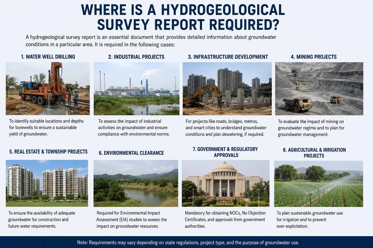
The demand for professional hydrogeological documentation spans nearly every sector that interacts with groundwater in India:
CGWA NOC and Regulatory Compliance: The Central Ground Water Authority requires a detailed hydrogeological study report as part of NOC applications for groundwater extraction in over-exploited, critical, and semi-critical assessment units across India.
Industrial and Manufacturing Units: Factories, food processing plants, textile units, and power projects need groundwater resource assessment reports to establish water supply reliability and satisfy environmental clearance conditions.
Borewell and Drinking Water Projects: Municipal bodies, rural water supply schemes, and private developers commission borewell survey reports to reduce drilling risk and maximise success rates.
Mining and Quarrying Operations: Mines require hydrogeological investigation to predict groundwater ingress, plan dewatering systems, and assess downstream impacts on community water sources.
Real Estate and Infrastructure Projects: Large residential townships, highways, and industrial estates near groundwater-sensitive zones need aquifer assessment reports for EIA submissions and construction safety planning.
Agricultural and Irrigation Planning: Irrigation project planners use groundwater feasibility reports to design canal command area water budgets and assess tube well viability for farm water security.
Why Choose Bhoojal Survey for Your Hydrogeological Survey Report
Bhoojal Survey is a trusted hydrogeological investigation company in India with deep field expertise and a proven record of delivering scientifically rigorous, compliance-ready groundwater reports:
- Senior hydrogeologists with extensive pan-India field experience across diverse geological settings
- Advanced geophysical instruments delivering high-resolution subsurface data
- Integrated field investigation, laboratory analysis, and GIS-based reporting workflows
- Reports prepared to CGWB, CGWA, and MoEFCC documentation standards
- Full consultancy support from site visit to final report submission and regulatory follow-up
- Customised groundwater assessment solutions for industrial, infrastructure, mining, and agricultural clients
Conclusion
A Hydrogeological Survey Report is the single most important document a groundwater project can have. It replaces assumption with evidence, reduces drilling risk, satisfies regulatory requirements, and lays the scientific foundation for sustainable groundwater use.
Whether you need a CGWA compliance report, a borewell investigation for an industrial unit, or a comprehensive aquifer assessment for a large infrastructure project, getting the hydrogeology right from the start protects your investment and your approval timeline.
📞 Contact Bhoojal Survey today to commission a professional Hydrogeological Survey Report tailored to your project requirements — anywhere in India.
Frequently Asked Questions (FAQs)
Q1. What is a Hydrogeological Survey Report? A Hydrogeological Survey Report is a scientific document that describes the groundwater conditions at a specific site, including aquifer depth, water availability, water quality, and recharge potential. It is prepared by qualified hydrogeologists using field investigation, geophysical surveys, and laboratory analysis to support groundwater planning and regulatory compliance.
Q2. Why is a Hydrogeological Survey Report required in India? It is required for CGWA NOC applications, environmental impact assessments, industrial groundwater extraction permits, mining dewatering approvals, and infrastructure projects near water-sensitive zones. It provides the scientific evidence regulators and project planners need to make informed groundwater decisions.
Q3. What information is covered in a groundwater survey report? A complete report covers site geology, aquifer type and depth, seasonal groundwater levels, estimated borewell yield, water quality analysis, recharge zone mapping, and technical recommendations for sustainable groundwater development or conservation.
Q4. Is a Hydrogeological Survey Report mandatory for CGWA approval? Yes. The Central Ground Water Authority requires a detailed hydrogeological investigation report as a core document for groundwater extraction NOC applications, particularly in over-exploited, critical, and semi-critical groundwater assessment units notified across India.
Q5. How long does it take to prepare a Hydrogeological Survey Report? Preparation time depends on site complexity and project scope. A standard report typically takes 7 to 21 working days from field investigation to final submission, covering geophysical surveys, laboratory water quality testing, data analysis, and professional report compilation.