Groundwater is one of India's most critical natural resources — yet it remains largely invisible and poorly understood without proper investigation. Before drilling a borewell, planning an irrigation system, or developing an industrial facility, knowing what lies beneath the surface is not optional. It is essential. This is exactly where a professional hydrogeological assessment becomes the foundation of every sound water resource decision.
At Bhoojal Survey, we provide scientific hydrogeological assessment services across India — helping industries, agricultural landowners, infrastructure developers, and government agencies make confident, data-backed groundwater decisions.
What Is Hydrogeological Assessment?
A hydrogeological assessment is a systematic scientific investigation of subsurface geological and hydrological conditions to evaluate groundwater availability, quality, and sustainability within a specific area.
It examines the relationship between underground rock formations, soil structure, and the movement of water through aquifer systems. The assessment identifies where groundwater is stored, how it recharges, how fast it moves, and how much can be sustainably extracted without long-term depletion.
In practical terms, a hydrogeological assessment answers the most critical questions any water-dependent project needs before it begins — Is groundwater available here? At what depth? In what quantity? And for how long? These answers directly determine borewell feasibility, irrigation planning viability, and industrial water supply security.
Why Hydrogeological Assessment Is Important
Skipping a proper hydrogeological assessment is one of the most expensive mistakes a project can make. Here is why this investigation is non-negotiable:
- Accurate Groundwater Resource Evaluation — Identifies true aquifer potential rather than relying on guesswork or neighbouring borewell data that may not apply.
- Better Borewell Success Rate — Scientific aquifer mapping dramatically increases the probability of striking water at the right depth and yield.
- Sustainable Groundwater Management — Groundwater sustainability assessment prevents over-extraction that leads to water table decline and borewell failure.
- Reduced Groundwater Extraction Risk — Understanding aquifer vulnerability prevents legal, environmental, and operational groundwater complications.
- Scientific Water Resource Planning — Government departments and irrigation planners use groundwater recharge assessment data to design long-term water supply infrastructure.
Whether you are planning a single borewell on agricultural land or designing a large-scale industrial groundwater system, a proper hydrogeological assessment reduces risk and improves outcomes significantly.
Methods Used in Hydrogeological Assessment
A credible hydrogeological assessment combines multiple investigation techniques to build a complete picture of subsurface groundwater conditions:
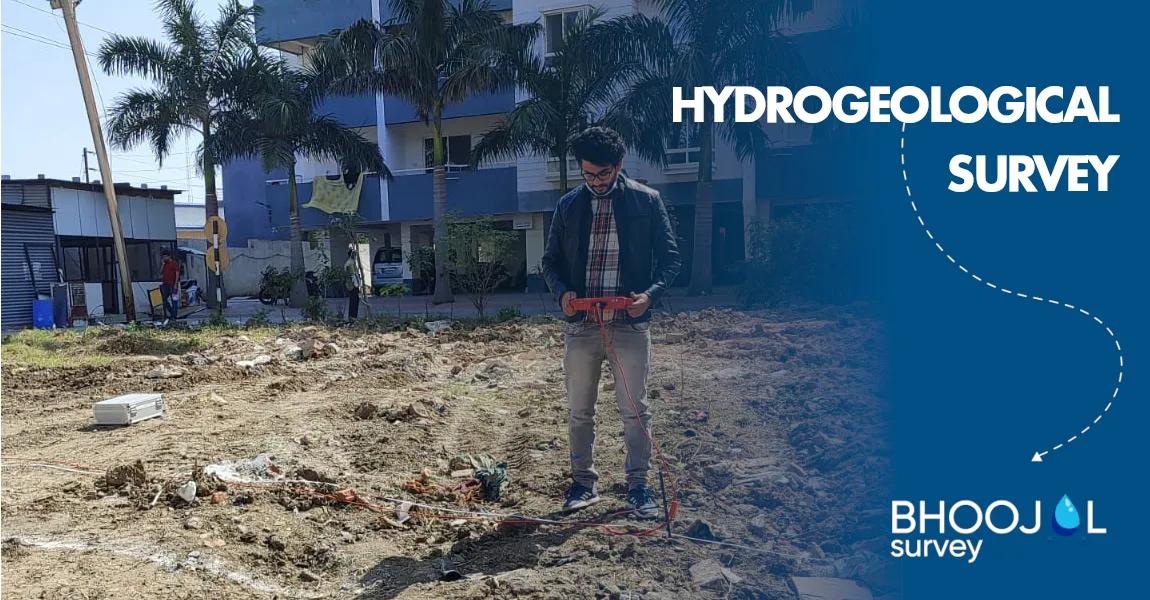
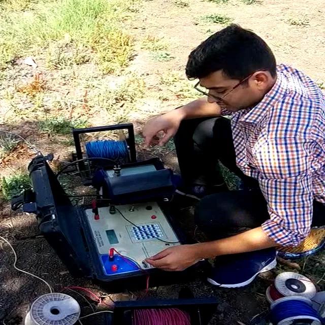
Electrical Resistivity Survey is the most widely used geophysical groundwater investigation method in India — measuring subsurface electrical resistance to identify water-bearing rock layers, fracture zones, and aquifer depth with precision.
Hydrogeological Investigation and Geological Terrain Analysis involves systematic field mapping of rock types, structural features, lineaments, and drainage patterns that influence groundwater recharge and movement.
GIS and Satellite-Based Groundwater Mapping integrates remote sensing data with field observations to identify groundwater potential zones across large areas — essential for regional water resource planning and aquifer mapping services.
Aquifer Interpretation and Pumping Tests assess aquifer transmissivity, storage capacity, and sustainable yield — critical inputs for borewell design and long-term groundwater resource management.
At Bhoojal Survey, our field specialists conduct comprehensive assessments by conducting hydrogeological surveys using SSRMPATS Instrument, GER DETECT, and PQWT at site for open well and borewell location — delivering advanced groundwater and geophysical survey solutions backed by rigorous scientific groundwater investigation and analysis.
Applications of Hydrogeological Assessment
The hydrogeological assessment framework serves a wide range of sectors across India:
- Agricultural Irrigation Projects — Identifying reliable groundwater sources for irrigation borewells and farm water supply systems
- Industrial Groundwater Systems — Feasibility assessment for factory, processing plant, and industrial estate water supply
- Infrastructure and Mining Projects — Groundwater dewatering analysis and aquifer impact assessment for tunnels, quarries, and open-cast mines
- Government Water Resource Planning — Supporting CGWB and state water departments with aquifer mapping and groundwater potential analysis
- Commercial Water Supply Systems — Hydrogeological study reports for hotels, townships, and commercial developments
- Residential Township Developments — Groundwater feasibility assessment for large-scale housing and integrated township projects
Why Choose Bhoojal Survey for Hydrogeological Assessment?
Bhoojal Survey is a leading hydrogeological investigation company in India, trusted across agriculture, industry, infrastructure, and government sectors:
- Experienced Hydrogeologists and Groundwater Experts with proven field investigation and aquifer analysis expertise
- Advanced Geophysical Survey Instruments including SSRMPATS, GER DETECT, and PQWT for precise underground water investigation
- Accurate Aquifer Mapping and Analysis aligned with CGWB and Geological Survey of India standards
- Pan-India Groundwater Survey Services covering hard rock, alluvial, and coastal aquifer terrains
- Professional Reporting and Consultancy delivering hydrogeological study reports suitable for regulatory, investment, and design purposes
- Customized Groundwater Solutions tailored to your project's specific geology, water demand, and compliance requirements
Conclusion
A professionally conducted hydrogeological assessment is the most reliable investment any water-dependent project can make before breaking ground. It removes uncertainty, improves borewell success rates, supports sustainable groundwater management, and provides the scientific evidence base that regulatory bodies, investors, and project planners require.
Bhoojal Survey combines advanced geophysical investigation technology, deep hydrogeological expertise, and a proven pan-India track record to deliver groundwater resource analysis services you can trust completely.
📞 Contact Bhoojal Survey today for expert hydrogeological assessment, scientific groundwater investigation solutions, and professional aquifer mapping consultancy services across India.
Frequently Asked Questions (FAQs)
Q1. What is a hydrogeological assessment? A hydrogeological assessment is a scientific investigation of subsurface geological and hydrological conditions that evaluates groundwater availability, aquifer structure, recharge potential, and sustainable extraction capacity for a specific location or project area.
Q2. Why is hydrogeological investigation important before drilling a borewell? Hydrogeological investigation identifies the correct depth, location, and expected yield of a borewell before drilling begins — significantly improving success rates and reducing the cost of failed or dry borewells.
Q3. Which methods are used for groundwater assessment in India? Common methods include electrical resistivity survey, GIS-based groundwater mapping, geological terrain analysis, satellite lineament mapping, and aquifer pumping tests — often combined for comprehensive hydrogeological study reports.
Q4. How accurate is resistivity survey for groundwater analysis? When conducted by experienced hydrogeologists with calibrated instruments, resistivity survey for groundwater analysis achieves high accuracy in identifying water-bearing zones, fracture locations, and aquifer depth — making it the most trusted geophysical method for borewell planning in India.
Q5. Which industries need professional hydrogeological assessment services in India? Agriculture, mining, infrastructure development, industrial manufacturing, real estate, and government water resource agencies all require professional hydrogeological assessment services for groundwater planning, regulatory compliance, and sustainable water supply management.