Before drilling a borewell or planning a major water supply project, understanding what lies beneath the surface is critical. A hydrogeological survey groundwater investigation provides the scientific foundation needed to locate aquifers, assess groundwater availability, and make informed decisions — saving time, money, and resources.
At Bhoojal Survey, we deliver professional hydrogeological survey services across India, combining advanced geophysical instruments with expert technical knowledge to help farmers, industries, government agencies, and infrastructure developers access reliable groundwater resources.
What is Hydrogeological Survey Groundwater?
A hydrogeological survey groundwater study is a scientific investigation that analyses the geology, rock formations, and subsurface water-bearing zones of a specific area. Its primary objective is to identify where groundwater exists, how much is available, how it moves underground, and how it can be sustainably extracted.
Hydrogeological surveys go beyond simple borewell detection. They evaluate aquifer depth and thickness, groundwater recharge potential, water quality indicators, and long-term availability — giving clients a complete picture of groundwater resources before any drilling or development begins.
This type of scientific groundwater investigation is essential for agricultural projects, industrial water supply planning, rural water schemes, infrastructure developments, and environmental assessments across India.
Methods Used in Hydrogeological Groundwater Surveys
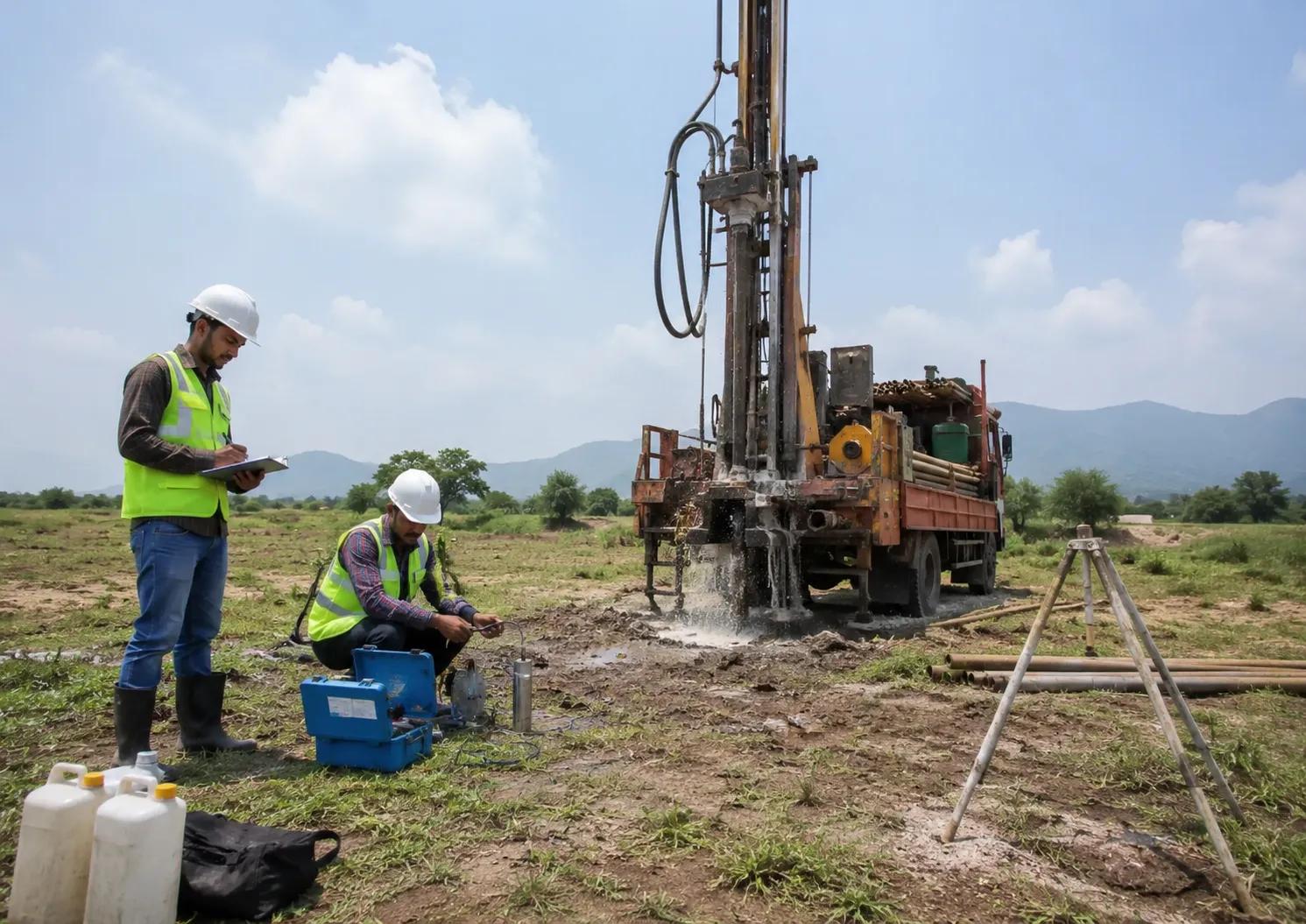
Professional hydrogeological groundwater surveys use a combination of field techniques and modern technology:
Hydrogeological Mapping — Field geologists study the surface geology, rock outcrops, soil types, drainage patterns, and landforms to identify zones favourable for groundwater occurrence.
Electrical Resistivity Surveys — Geophysical instruments measure the electrical resistance of subsurface formations, distinguishing water-bearing strata from dry or impermeable rock layers with high accuracy.
Geological Investigations — Analysis of rock types, fracture patterns, fault zones, and lithological sequences helps determine aquifer characteristics and groundwater movement pathways.
Satellite and GIS Analysis — Remote sensing data and geographic information systems are used to map lineaments, drainage basins, and recharge zones across large project areas efficiently.
Aquifer Characterisation Studies — Pumping tests, water level monitoring, and lithological log analysis help define aquifer boundaries, hydraulic conductivity, and sustainable yield estimates.
Together, these methods ensure that groundwater exploration is based on data, not guesswork.
Benefits of Hydrogeological Survey Groundwater
Investing in a scientific hydrogeological survey before groundwater development delivers significant benefits:
Improved Groundwater Identification — Surveys pinpoint the most productive aquifer zones, increasing confidence in borewell and open well locations.
Better Borewell Success Rates — Scientific site selection dramatically reduces the risk of dry or low-yield borewells, which are costly and time-consuming failures.
Reduced Drilling Risks — Understanding subsurface geology before drilling avoids unstable formations, hard rock complications, and unexpected technical challenges.
Scientific Groundwater Resource Planning — Hydrogeological data supports long-term water resource planning for irrigation development, industrial supply systems, and rural water schemes.
Sustainable Groundwater Management — Surveys assess recharge rates and aquifer capacity, helping clients develop groundwater responsibly without depleting underground reserves.
At Bhoojal Survey, we specialise in conducting hydrogeological survey using SSRMPATS Instrument, GER DETECT, and PQWT at site for open well / borewell location. Our advanced groundwater and geophysical survey solutions ensure precise subsurface analysis, while our scientific groundwater investigation and analysis delivers reliable, actionable results for every project.
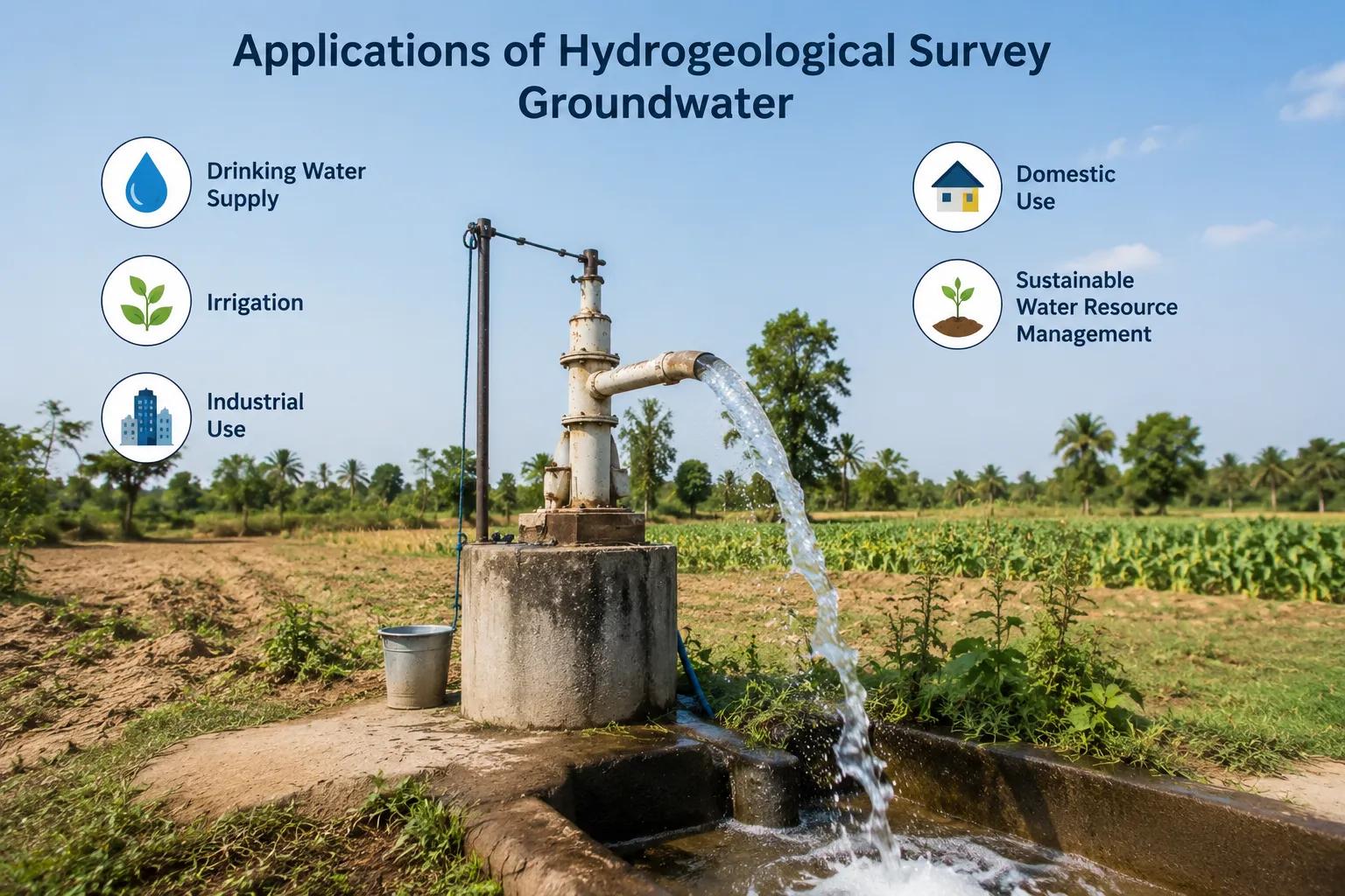
Applications of Hydrogeological Survey Groundwater
Hydrogeological groundwater surveys serve a wide range of sectors and project types:
Borewell Location Identification — Farmers and landowners use survey results to select the most productive borewell sites, improving drilling success across agricultural regions of India.
Agricultural Irrigation Projects — Groundwater resource assessments support irrigation planning by determining aquifer yield and sustainable extraction limits for crop production.
Industrial Water Supply Systems — Manufacturing plants, processing facilities, and industrial parks depend on reliable groundwater assessments to plan captive water supply infrastructure.
Infrastructure Developments — Roads, bridges, tunnels, and construction projects require groundwater investigations to assess dewatering needs, foundation stability risks, and water supply availability.
Mining Operations — Mining companies require detailed hydrogeological investigations to understand groundwater inflow risks, plan dewatering systems, and comply with environmental regulations.
Government Water Resource Projects — Central and state government schemes for rural water supply, watershed development, and irrigation rely on professional hydrogeological survey services for scientific planning and implementation.
Why Choose Bhoojal Survey?
Bhoojal Survey is a leading groundwater exploration consultancy in India, trusted by farmers, developers, government bodies, and industrial clients for accurate, reliable hydrogeological investigations.
Our strengths include:
- Experienced hydrogeologists and geophysicists with extensive field expertise across diverse geological terrains
- Advanced groundwater survey instruments including SSRMPATS, GER DETECT, and PQWT systems for precise subsurface analysis
- Accurate aquifer and groundwater analysis that reduces borewell failure rates and optimises site selection
- Professional technical reporting that meets the standards required for government approvals, environmental assessments, and project planning
- Pan-India survey services covering plains, hard rock terrains, alluvial zones, and coastal aquifer systems
- Customised groundwater management solutions designed around the specific needs and objectives of each client
From small farm borewells to large-scale industrial water supply investigations, Bhoojal Survey delivers scientific excellence at every scale.
Conclusion
A professional hydrogeological survey groundwater investigation is not an optional step — it is the foundation of responsible groundwater development. Whether you are planning a borewell for agricultural irrigation, a water supply system for an industrial facility, or a large-scale government water project, scientific groundwater investigation ensures that decisions are based on reliable data, not assumptions.
Bhoojal Survey brings together advanced geophysical technology, experienced hydrogeologists, and proven survey methodologies to deliver precise, trustworthy groundwater assessments across India.
Contact Bhoojal Survey today to discuss your hydrogeological survey requirements. Our experts are ready to help you locate, assess, and manage groundwater resources with confidence and scientific precision.
Frequently Asked Questions (FAQs)
Q1. What is a hydrogeological groundwater survey? A hydrogeological groundwater survey is a scientific investigation that studies subsurface geology and rock formations to identify groundwater-bearing zones, assess aquifer characteristics, and determine groundwater availability. It provides the data needed for informed borewell planning and sustainable water resource development.
Q2. Why is a hydrogeological survey important before borewell drilling? A hydrogeological survey before borewell drilling helps identify the most productive aquifer zones, reducing the risk of dry borewells and wasted investment. Scientific site selection significantly improves drilling success rates for farmers, industries, and infrastructure developers across India.
Q3. Which methods are used in hydrogeological groundwater investigations? Common methods include electrical resistivity surveys, hydrogeological mapping, geological field investigations, GIS and satellite analysis, and aquifer characterisation studies. Advanced instruments such as SSRMPATS, GER DETECT, and PQWT are used for precise subsurface groundwater detection at borewell and open well sites.
Q4. How accurate are hydrogeological groundwater surveys? When conducted by experienced hydrogeologists using calibrated geophysical instruments, hydrogeological surveys provide high accuracy in identifying productive groundwater zones. Accuracy depends on instrument quality, geological complexity, and the experience of the survey team — all of which Bhoojal Survey prioritises in every project.
Q5. How long does a groundwater survey take? The duration of a hydrogeological groundwater survey depends on the size of the project area, geological complexity, and survey methods required. A standard site survey for borewell location can typically be completed within one to two days, while larger aquifer mapping or resource assessment projects may require additional field investigations and analysis time.