Scientific Investigation for Accurate Drilling
Drilling a borewell without proper investigation is like digging in the dark. A professional ground water survey for borewell removes this uncertainty entirely. It uses advanced geophysical and hydrogeological methods to locate underground water zones before a single drill bit touches the ground.
At Bhoojal Survey, we provide scientific groundwater exploration services designed for agriculture, industry, infrastructure, and residential projects across India. Our approach combines technical precision with field experience — giving clients accurate borewell locations, reduced drilling failure, and long-term water security.
What is Ground Water Survey for Borewell?
A ground water survey for borewell is a systematic scientific investigation conducted to identify the depth, location, and yield potential of underground water-bearing zones called aquifers before borewell drilling begins.
It involves geophysical survey techniques, hydrogeological borewell investigation, and aquifer analysis for borewell planning. The survey maps subsurface geological formations, identifies fracture zones, and determines where groundwater is most likely to be available in sufficient quantity.
Without this investigation, borewell drilling becomes a costly gamble. With it, success rates improve significantly — saving time, money, and resources for farmers, developers, and project planners.
Why Ground Water Survey for Borewell is Important
Skipping a borewell site survey often results in dry borewells, inadequate water yield, and wasted drilling budgets. Here is why a scientific borewell groundwater survey matters:
- Higher borewell success rate — targeted drilling based on aquifer analysis reduces failure dramatically
- Reduced dry borewell risk — resistivity survey for groundwater identifies water-bearing zones accurately
- Better groundwater resource planning — data-driven decisions for long-term sustainable extraction
- Significant cost savings — avoid repeated drilling attempts in wrong locations
- Sustainable water use — groundwater recharge assessment ensures you tap renewable aquifers
- Reliable data for project planning — essential for irrigation, construction, and industrial water supply systems
For farmers, this means reliable irrigation water. For industries, it means uninterrupted water supply. For developers, it means project viability and compliance.
Methods Used in Ground Water Survey for Borewell
Bhoojal Survey deploys advanced groundwater and geophysical survey solutions tailored to each site's geology and project requirement.
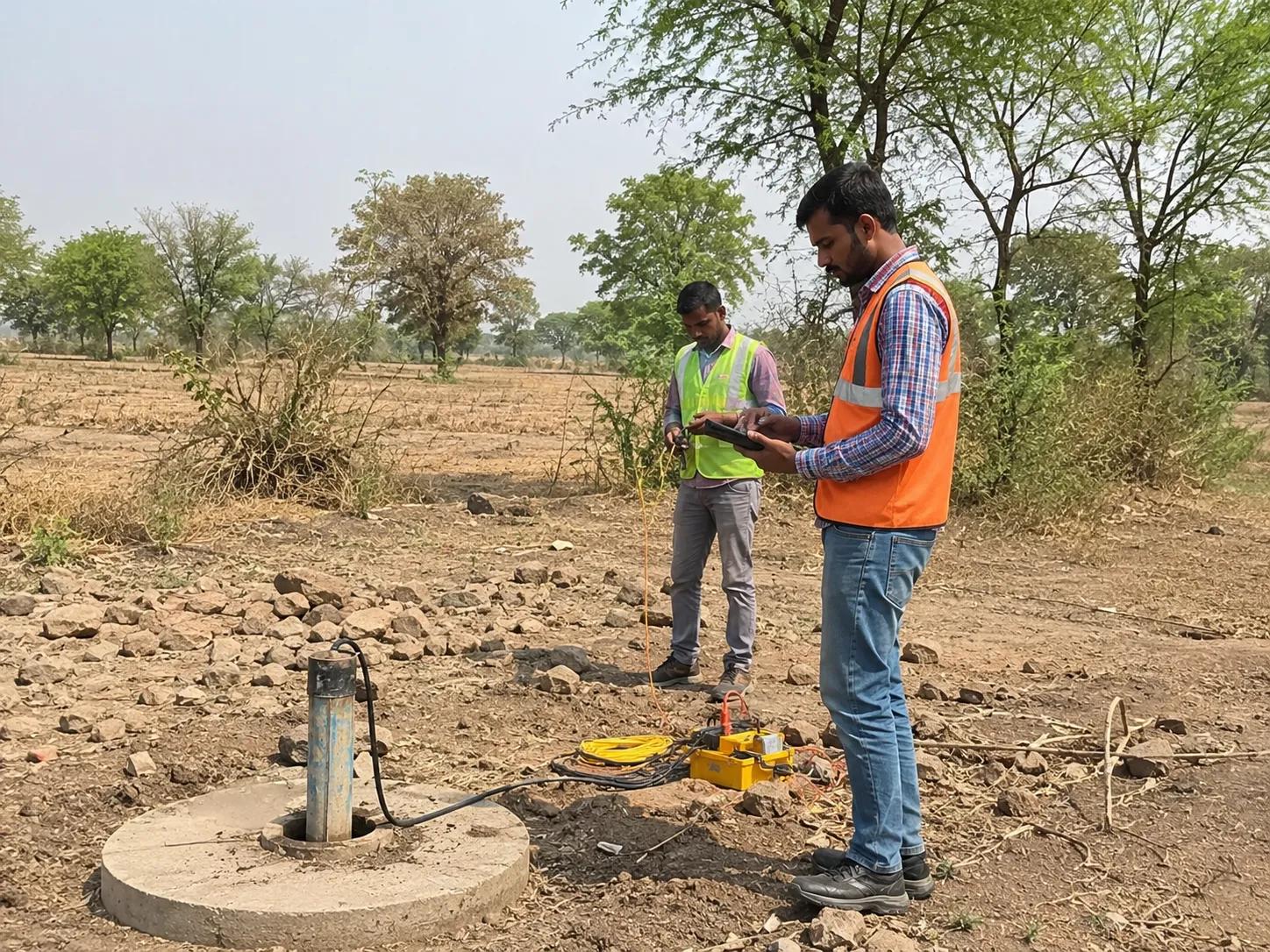
Electrical Resistivity Survey is the most widely used technique. It measures the electrical resistance of subsurface layers to distinguish water-bearing zones from dry rock or clay. This method forms the backbone of any reliable groundwater detection survey.
Hydrogeological Borewell Investigation studies the relationship between local geology, rainfall, terrain, and groundwater movement. It provides a complete picture of aquifer behaviour and recharge patterns.
Geological Terrain Analysis identifies surface features, rock types, and structural geology that influence groundwater accumulation. Hard rock terrain, alluvial plains, and fractured zones each require different survey approaches.
GIS and Satellite Groundwater Mapping adds spatial intelligence to borewell planning. Remote sensing data combined with field investigation improves groundwater mapping services accuracy across large project areas.
Aquifer Interpretation determines the depth, thickness, and water potential of each aquifer zone identified during the survey.
Our team is experienced in conducting hydrogeological surveys using SSRMPATS Instrument, GER DETECT, and PQWT at site for open well and borewell location — ensuring field-level accuracy backed by scientific groundwater investigation and analysis.
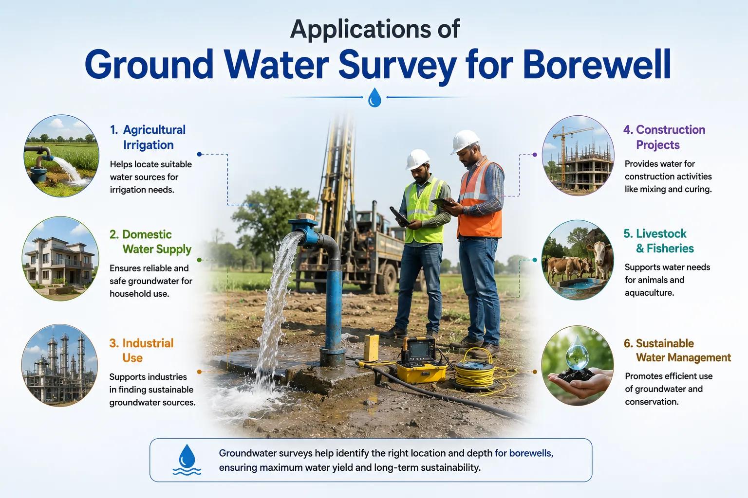
Our borewell drilling survey services support a wide range of sectors:
- Agricultural irrigation projects — ensuring reliable groundwater for crop irrigation across seasonal demand
- Industrial water supply systems — meeting process water requirements for factories and plants
- Residential township developments — water sourcing for housing projects and gated communities
- Infrastructure and construction projects — site water supply planning for roads, bridges, and buildings
- Mining and environmental projects — dewatering studies and groundwater impact assessments
- Government rural water supply schemes — supporting Jal Jeevan Mission and state water programs
Each application demands accurate borewell feasibility survey data — and that is exactly what Bhoojal Survey delivers.
Why Choose Bhoojal Survey
Bhoojal Survey is a trusted groundwater investigation consultancy with deep field experience across India's diverse geological terrains.
- Experienced hydrogeologists and groundwater experts with hands-on project knowledge
- Advanced geophysical survey instruments including SSRMPATS, GER DETECT, and PQWT
- Accurate aquifer mapping and groundwater resource analysis for every project type
- Professional reporting with clear drilling recommendations and depth targets
- Pan-India groundwater survey services covering agricultural, industrial, and urban projects
- Customized borewell survey solutions designed around your site's specific geology and water demand
We understand that every site is different. Our team conducts site-specific scientific borewell investigation to deliver results you can drill with confidence.
Conclusion
A ground water survey for borewell is not an optional step — it is the foundation of every successful borewell drilling project. Scientific hydrogeological analysis, resistivity survey, and aquifer mapping together eliminate guesswork and significantly improve drilling outcomes.
Bhoojal Survey brings proven expertise, advanced instruments, and a commitment to accuracy to every groundwater investigation project. Whether you are a farmer planning irrigation, a developer sourcing water for a township, or a government body executing rural water schemes — our professional consultancy ensures you drill in the right place, at the right depth, every time.
Contact Bhoojal Survey today for a professional ground water survey for borewell — and make your next borewell a success.
Frequently Asked Questions
Q1. What is a ground water survey for borewell? A ground water survey for borewell is a scientific investigation that uses geophysical and hydrogeological methods to locate underground water zones before drilling. It identifies aquifer depth, location, and yield potential to ensure successful and cost-effective borewell drilling.
Q2. Which method is best for borewell groundwater detection? The electrical resistivity survey is the most reliable method for groundwater detection before borewell drilling. It accurately maps subsurface water-bearing zones by measuring how different geological layers conduct electricity. At Bhoojal Survey, we also use SSRMPATS, GER DETECT, and PQWT instruments for precise field results.
Q3. How accurate is a resistivity survey for borewell location? A resistivity survey for groundwater is highly accurate when conducted by experienced hydrogeologists using calibrated instruments. Combined with geological terrain analysis and hydrogeological investigation, accuracy in identifying productive borewell locations is significantly higher than drilling without any survey.
Q4. Why is hydrogeological investigation important before borewell drilling? Hydrogeological investigation reveals how groundwater moves through local rock formations, where aquifers are recharged, and which zones hold sufficient water for long-term extraction. Without this analysis, borewells may fail or yield insufficient water, leading to wasted drilling costs.
Q5. How long does a borewell groundwater survey take? A standard ground water survey for borewell typically takes one to two days per site, depending on the area size and geological complexity. Bhoojal Survey provides a complete survey report with drilling recommendations within a few days of field investigation completion.