Flood Model Project
Monsoon variability, rapid urbanization, and altering terrain across India have made seasonal flooding a critical challenge for modern infrastructure. To safeguard multi-million dollar investments, engineers and planners rely heavily on advanced predictive simulations.
A flood model project is a comprehensive, data-driven scientific study that uses hydrological and hydraulic engineering to simulate how water moves across landscapes, channels, and built environments during extreme rainfall events. By executing a flood model project, developers and state agencies can accurately map inundation zones, assess structural vulnerabilities, and engineer resilient drainage systems before breaking ground.
For smart city planners, highway developers, and industrial giants, a flood model project is not just a regulatory checklist—it is the foundation of structural sustainability and public safety.
What is a Flood Model Project?
A flood model project is an engineering blueprint designed to analyze, predict, and mitigate water accumulation risks. The primary objective is to replicate real-world catchment behavior within digital environments using mathematical and computational algorithms.
In modern disaster risk management, these projects replace guesswork with precision. By calculating how localized terrain handles extreme weather, a flood model project predicts exactly where water will flow, how deep it will pool, and how fast it will recede. This predictive intelligence allows stakeholders to design flood mitigation assets, optimize layout planning, and formulate fail-safe emergency evacuation plans well in advance.
Key Components of a Flood Model Project
Executing a robust flood simulation project requires a systematic blend of meteorology, terrain analysis, and fluid mechanics:
- Rainfall Data Analysis: Assessing historical rainfall patterns and return periods (e.g., 50-year or 100-year flood events) to determine peak precipitation volume.
- Watershed Flood Assessment: Studying the local catchment area, soil types, and land-use patterns to compute accurate rainfall runoff analysis.
- Topographic & DEM Integration: Utilizing high-resolution Digital Elevation Models (DEM) and drone survey data to map terrain contours.
- Hydraulic Simulations: Running specialized software to track fluid dynamics, channel capacities, and flow velocities through rivers, canals, and urban networks.
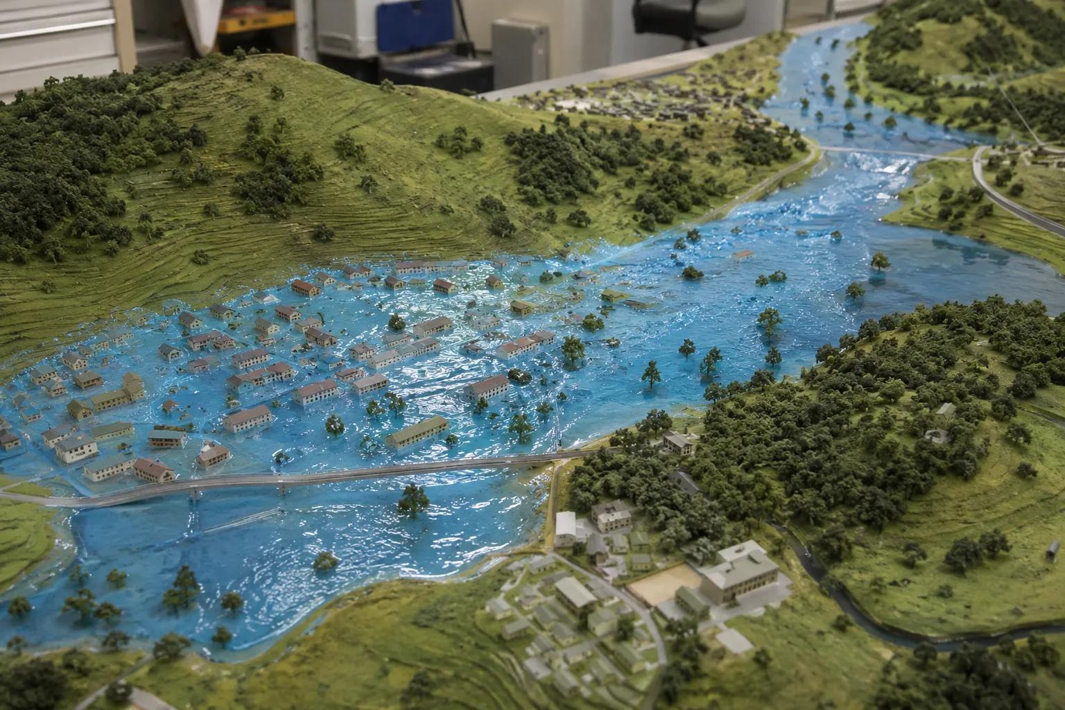
- GIS Flood Mapping: Converting complex mathematical calculations into highly visual flood inundation mapping for easy interpretation by project managers.
Applications of Flood Model Projects in India
From major river basin management projects to sprawling smart city infrastructure projects, scientific simulations are redefining how India builds.
Highway, Rail, and Bridge Developments
Linear infrastructure frequently alters natural drainage pathways. A structured river flood analysis ensures that bridges, culverts, and national highway embankments are elevated above maximum flood levels, preventing costly washouts and transit disruptions.
Industrial and Urban Infrastructure Planning
Heavy industries, power plants, and manufacturing hubs require complete operational continuity. A customized flood risk assessment protects high-value equipment assets from sudden stormwater surges.
Integrated Water and Site Investigations
Comprehensive site readiness requires analyzing both surface water risks and subsurface resources. Bhoojal Survey delivers advanced hydrological and geospatial survey solutions, combining surface flood studies with on-site underground exploration, such as conducting hydrogeological survey using SSRMPATS Instrument, GER DETECT, and PQWT at site for open well / borewell location. This integration ensures structural safety above ground while validating dependable groundwater sources below.
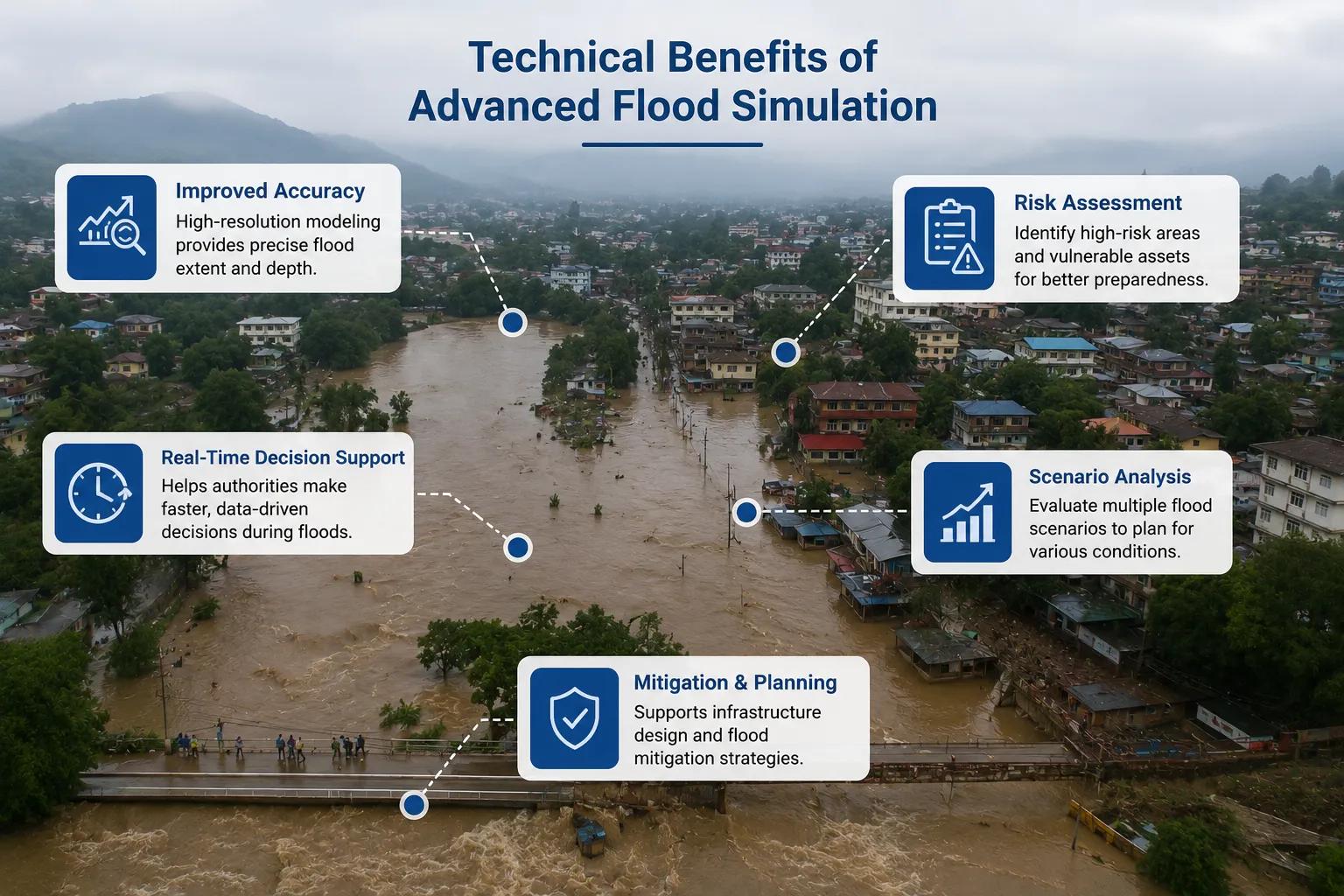
Technical Benefits of Advanced Flood Simulation
Investing in a professional flood model project delivers distinct structural and financial advantages for master-planned developments:
[Advanced Hydrological Modelling] │ ▼ [GIS Flood Hazard Analysis] │ ┌───────┴───────┐ ▼ ▼ [Optimized Design] [Reduced Asset Damage] │ │ └───────┬───────┘ ▼ [Long-Term Climate Resilience]
By utilizing high-tier flood forecasting model pipelines, civil engineers can reduce construction material waste by sizing drains accurately. Additionally, proper floodplain mapping accelerates environmental compliance clearances, builds strong stakeholder trust, and drastically lowers future insurance premiums for industrial zones.
Why Choose Bhoojal Survey?
Bhoojal Survey is a premier hydrological modelling company in India, offering end-to-end scientific flood investigation solutions for complex engineering sectors.
- Elite Engineering Team: Our senior hydrologists and hydraulic modelers possess deep expertise in river basin flood study dynamics.
- Advanced Simulation Technology: We use industry-standard software to build highly accurate 1D and 2D flood models.
- Comprehensive Risk Mapping: From flood vulnerability assessment reports to strategic flood management planning, we handle it all.
- Pan-India Project Execution: We deliver tailored engineering consultancy suited to India’s diverse geographic and climatic zones.
Conclusion
A scientifically validated flood model project is an indispensable asset for modern, climate-resilient development. By replacing reactive disaster control with proactive, data-driven engineering, developers can confidently secure their investments against extreme weather.
Ensure your infrastructure stands resilient. Contact Bhoojal Survey today for a specialized flood risk assessment consultancy consultation tailored to your project.
Frequently Asked Questions
1. What is a flood model project?
It is a comprehensive engineering study that simulates rainfall and water flow across specific terrains using digital models to predict and mitigate potential flooding risks.
2. Why is hydraulic modelling crucial for urban smart cities?
It maps out how complex concrete surfaces impact stormwater accumulation, allowing planners to design adequate drainage networks to prevent localized urban logging.
3. What data is required to start a flood simulation project?
Key requirements include high-resolution topographic terrain data (DEM), historical meteorological rainfall data, local soil details, and river cross-section dimensions.
4. How accurate are modern flood prediction modelling solutions?
When backed by precise field data and high-resolution digital elevation models, modern 2D simulations offer exceptional accuracy for pinpointing future water depths and flow paths.
5. Which regulatory bodies mandate a flood hazard analysis in India?
Industrial boards, environmental clearance committees, and municipal authorities frequently require these studies prior to approving major infrastructure projects near water bodies.