Introduction
A flood model is a scientific simulation that predicts how water will behave during a flood event — where it will flow, how deep it will get, and how long it will last. Knowing how to make a flood model is essential for engineers, planners, and disaster management authorities who need accurate data to protect lives and infrastructure.
Flood models combine hydrological and hydraulic data to recreate real-world conditions in a digital environment. They are used for flood risk assessment, floodplain mapping, infrastructure design, and emergency planning. In a country like India — where monsoon flooding affects millions every year — professional flood modelling is not optional. It is critical.
What is a Flood Model
A flood model is a computational representation of how water moves through a catchment or river system during a rainfall or storm event. It helps answer key questions: Which areas will flood? How deep will the water be? How fast will it rise?
There are two primary types:
- Hydrological models — simulate rainfall-runoff processes and water movement across a watershed
- Hydraulic models — simulate water flow within river channels and floodplains
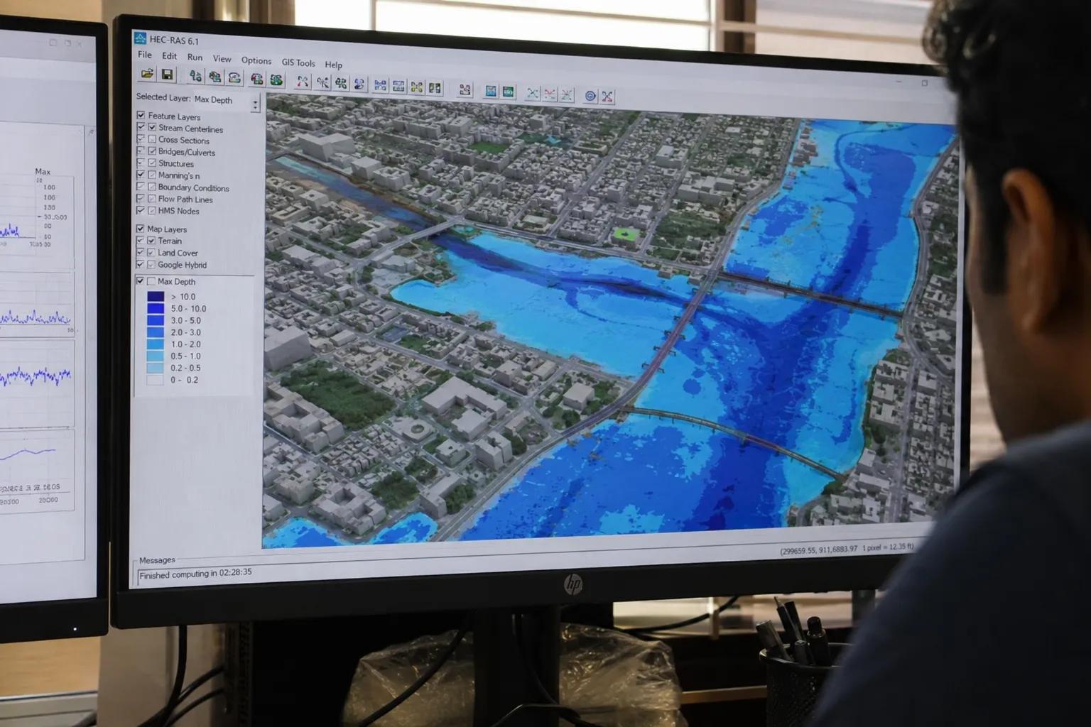
Modern flood modelling often combines both approaches for comprehensive flood inundation mapping and flood risk analysis. Tools like HEC-HMS, HEC-RAS, MIKE FLOOD, and SWMM are widely used in professional flood model development.
Data Required to Make a Flood Model
Before building any flood simulation model, high-quality data is essential. The key inputs include:
- Rainfall data — historical precipitation records, intensity-duration-frequency curves
- River flow data — discharge measurements, stage-flow relationships
- Digital Elevation Model (DEM) — terrain data for defining flow paths and floodplain extent
- Land use and watershed data — surface cover, soil types, infiltration characteristics
- Historical flood records — past inundation extents for model calibration and validation
The accuracy of a flood model depends entirely on the quality of this input data. Poor data leads to unreliable predictions and flawed flood hazard mapping.
Step-by-Step Process to Make a Flood Model
Here is a structured approach to how flood models are developed professionally:
Step 1 — Define Project Objectives Establish the purpose: Is this for flood forecasting, urban drainage planning, infrastructure design, or disaster management? The objective shapes every subsequent decision.
Step 2 — Data Collection and Field Investigation Collect all relevant hydrological, topographic, and land use data. Field surveys are critical here. For comprehensive site investigation, professional teams carry out advanced hydrological and geospatial survey solutions — including conducting hydrogeological surveys using SSRMPATS Instrument, GER DETECT, and PQWT at site for open well and borewell location identification, ensuring subsurface conditions are accurately captured.
Step 3 — Watershed Analysis Delineate the catchment boundary, identify drainage networks, calculate basin parameters like area, slope, and time of concentration. GIS flood analysis tools are used extensively at this stage.
Step 4 — Hydrological Modelling Build the rainfall-runoff model to estimate peak discharge at key locations within the watershed. This forms the hydrological input for the hydraulic stage.
Step 5 — Hydraulic Simulation Set up the hydraulic model with channel geometry, roughness values, and boundary conditions. Run simulations for various return period storms (1-in-10-year, 1-in-100-year events) to assess flood inundation extent and depth.
Step 6 — Flood Inundation Mapping Generate spatial flood maps showing areas at risk, water depths, and flow velocities — the core output of any scientific flood investigation and analysis.
Step 7 — Model Calibration and Validation Compare model outputs against observed flood data. Adjust parameters until the model accurately reproduces historical events. This step determines how reliable the flood prediction model truly is.
Step 8 — Result Interpretation and Reporting Translate technical outputs into actionable findings for planners, engineers, and decision-makers.
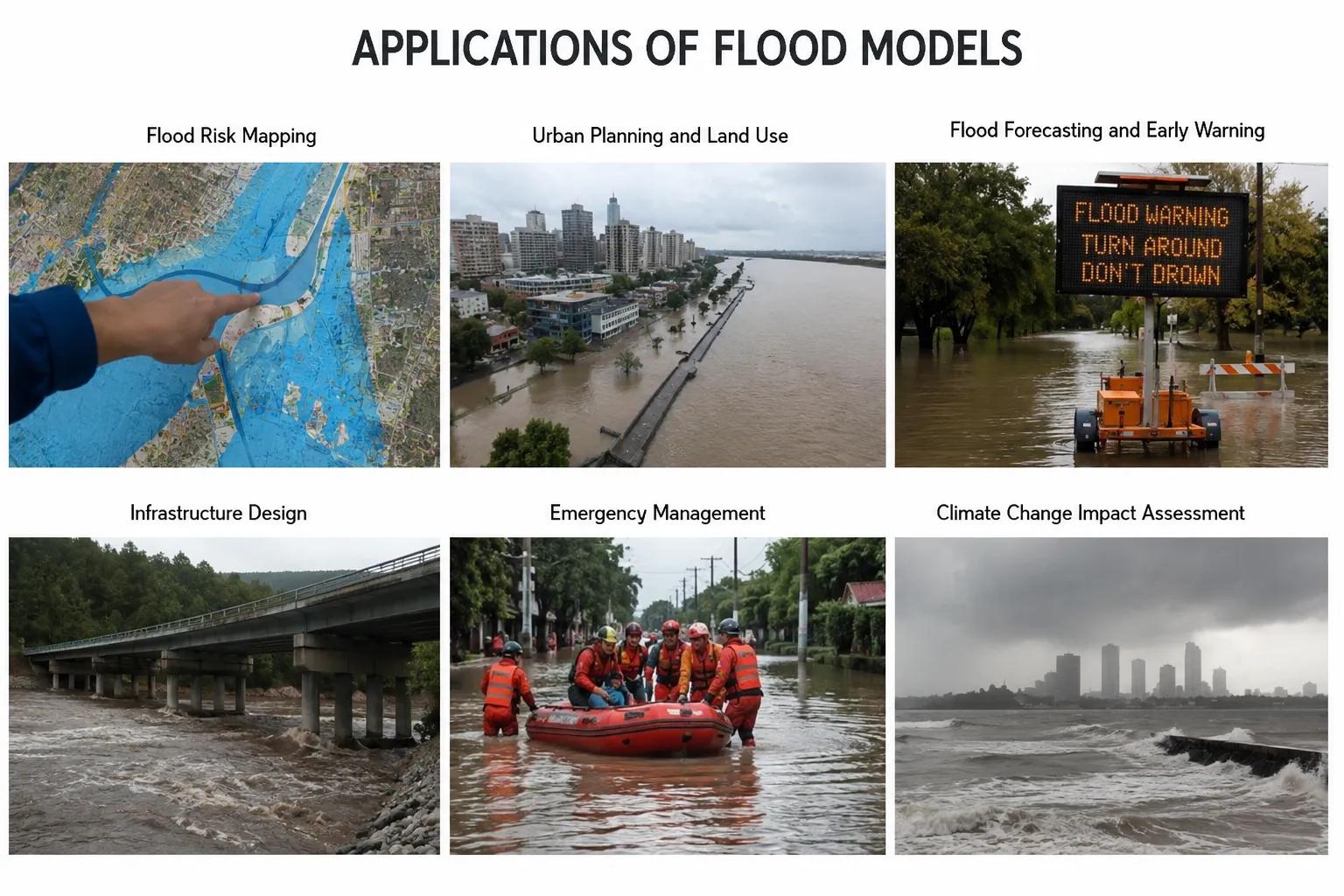
A well-built flood model serves multiple purposes:
- Flood forecasting — early warning systems for communities and emergency services
- River basin management — integrated planning for sustainable water resource use
- Urban flood planning — smart city drainage and stormwater management design
- Highway and bridge projects — hydraulic design of culverts, bridges, and road crossings
- Smart city development — resilient infrastructure planning in flood-prone zones
- Disaster management planning — evacuation route planning and risk zone delineation
Across India, flood modelling is increasingly embedded into infrastructure approvals, river restoration projects, and national disaster preparedness programs.
Why Choose Bhoojal Survey
Bhoojal Survey is a professional hydrological and flood modelling consultancy delivering scientific solutions across India. Our capabilities include:
- Experienced hydrologists and flood modelling specialists
- Advanced GIS, remote sensing, and hydraulic modelling technologies
- Scientific flood risk assessment and floodplain mapping
- Comprehensive professional reporting tailored to regulatory and engineering needs
- Pan-India flood simulation and watershed assessment services
- Customized flood management solutions for government, infrastructure, and urban development projects
We bring field expertise and technical precision together — from initial data collection to final flood hazard mapping.
Conclusion
Understanding how to make a flood model is fundamental for anyone working in water resource management, infrastructure planning, or disaster mitigation. The process demands quality data, scientific methodology, validated simulation tools, and experienced interpretation.
Getting flood modelling wrong has real consequences — failed infrastructure, inadequate evacuations, and avoidable losses. Getting it right starts with choosing the right consultancy.
Contact Bhoojal Survey today for professional flood modelling, flood risk assessment, and hydrological consultancy services anywhere in India.
Frequently Asked Questions (FAQs)
Q1. How to make a flood model step by step? Start with defining objectives, then collect hydrological and topographic data, perform watershed analysis, build the hydrological and hydraulic models, generate flood inundation maps, and validate results against historical flood data.
Q2. What software is used for flood modelling? Commonly used software includes HEC-HMS and HEC-RAS (by US Army Corps of Engineers), MIKE FLOOD, SWMM, and TUFLOW. GIS platforms like ArcGIS and QGIS are used for spatial analysis and flood hazard mapping.
Q3. What data is needed for flood simulation? Key data includes rainfall records, river discharge data, Digital Elevation Models (DEM), land use maps, soil data, and historical flood inundation records for model calibration.
Q4. Why is flood modelling important in India? India faces severe annual flooding due to monsoon variability and river dynamics. Flood modelling helps governments and developers design resilient infrastructure, plan evacuation zones, and implement early warning systems effectively.
Q5. How accurate are flood models? Accuracy depends on data quality, model calibration, and the complexity of the terrain. Professionally calibrated and validated flood models can predict inundation extents with high reliability — sufficient for engineering design and disaster planning decisions.