flood model project
A flood model project is a scientific process that simulates how floodwaters behave across a landscape under different rainfall and river-flow conditions. It combines hydrological investigation, hydraulic analysis, and GIS flood mapping to produce accurate predictions of flood extent, depth, and velocity. For infrastructure developers, government bodies, smart city planners, and disaster management agencies, a well-executed flood model project is essential for protecting lives, assets, and the environment.
In India, where monsoon-driven floods cause billions in losses every year, reliable flood risk assessment is no longer optional — it is a regulatory and engineering necessity. Bhoojal Survey delivers end-to-end flood modelling project services backed by advanced GIS technology, experienced hydrologists, and proven field investigation methods.
What is a Flood Model Project?
A flood modelling project is a structured technical study that uses hydrological and hydraulic simulation tools to replicate real-world flood behaviour. The process begins with collecting rainfall data, river discharge records, topographic surveys, and soil permeability information. This data feeds into computational models — such as HEC-HMS, HEC-RAS, or MIKE FLOOD — that generate detailed flood inundation maps and flood hazard scenarios.
The output of a flood simulation project includes flood depth maps, velocity profiles, and return period analysis, all essential for informed decision-making in urban planning, environmental flood assessment, and disaster preparedness.
Why Flood Model Projects Are Important
Flood model projects serve as the scientific foundation for flood risk reduction and resilient infrastructure development. Here is why they are critical:
1. Infrastructure Protection: Highways, bridges, and urban drainage systems designed without flood data face costly failures. A flood model project provides the hydraulic parameters engineers need.
2. Disaster Mitigation Planning: Government agencies and disaster management bodies use flood prediction systems to plan evacuation routes, early warning systems, and emergency response.
3. Urban Flood Planning: Smart city projects require stormwater flood analysis to design drainage networks that can handle peak rainfall events.
4. Environmental Compliance: Environmental impact assessments for industrial and mining projects must include environmental flood assessment to meet regulatory approvals.
5. Watershed and Floodplain Management: Watershed flood analysis identifies catchment-level risks and guides sustainable land-use planning.
Methods Used in Flood Model Projects
Bhoojal Survey applies a multi-layered technical methodology in every flood model project to ensure accuracy, reliability, and regulatory compliance.
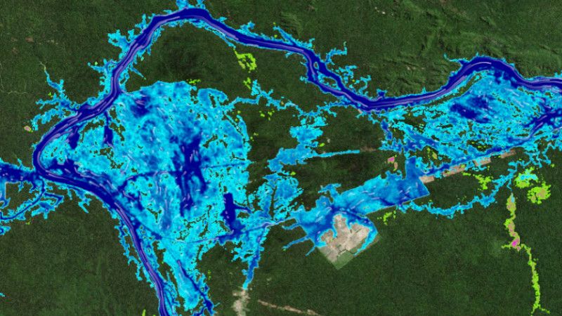
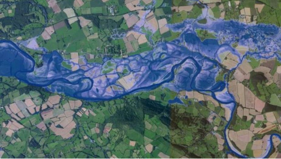
1. GIS Flood Mapping: High-resolution satellite imagery and Digital Elevation Models (DEMs) are processed using GIS platforms to delineate floodplains and drainage basins with precision.
2. Hydrological Watershed Analysis: Rainfall-runoff modelling is performed at the watershed level to estimate peak discharge values for different return periods (25-year, 50-year, 100-year floods).
3. Hydraulic Flood Modelling: 1D and 2D hydraulic simulation modelling replicates river flow dynamics, overbank flooding, and urban inundation scenarios.
4. Terrain and Floodplain Analysis: LiDAR and SRTM terrain data support detailed floodplain analysis to identify low-lying zones and natural flood corridors.
5. Flood Forecasting Techniques: Real-time flood forecasting integrates meteorological inputs with hydrological models for early warning outputs.
Our field teams are trained in conducting hydrogeological surveys using SSRMPATS Instrument, GER DETECT, and PQWT at site for open well / borewell location, integrating subsurface data directly into the hydrological investigation workflow for enhanced accuracy.
Applications of Flood Model Projects
Our flood model project services support a wide range of industries and government initiatives across India:
1. Smart city infrastructure projects and urban drainage master plans
2. Riverfront development and river channel realignment studies
3. Highway and bridge design requiring hydraulic clearance and scour analysis
4. Urban drainage systems and stormwater management projects
5. Environmental impact assessments for industrial and mining consultancies
6. Watershed management projects under PMKSY and state irrigation departments
7. Government flood mitigation planning under NDMA and CWC guidelines
Why Choose Bhoojal Survey for Your Flood Model Project
Bhoojal Survey is a trusted name in hydrological and environmental consultancy across India. When you engage us for a flood model project, you receive:
1. Experienced Hydrological Experts: A team with deep expertise in river flood modelling, watershed hydrology, and environmental flood assessment.
2. Advanced GIS and Simulation Technology: State-of-the-art GIS flood mapping software, hydraulic simulation tools, and drone-assisted topographic surveys.
3. Accurate Flood Risk Analysis: Data-driven flood vulnerability assessment and flood hazard mapping with validated results.
4. Professional Reporting: Detailed technical reports compliant with CWC, NDMA, and Ministry of Jal Shakti standards.
5. Pan-India Consultancy Services: Project experience spanning urban, rural, riverine, and coastal flood environments across India.
6. Customised Hydrological Solutions: Every flood model project is tailored to your site conditions, project goals, and budget requirements.
A well-executed flood model project is the cornerstone of safe infrastructure design, resilient urban planning, and effective disaster risk management. From scientific flood inundation mapping to real-time flood prediction systems, the value of accurate hydrological flood analysis cannot be overstated — especially in India's climate-vulnerable landscape.
Bhoojal Survey brings the scientific rigour, GIS capability, and field experience required to deliver flood modelling projects that stand up to regulatory scrutiny and real-world flood conditions. Whether you are planning a smart city drainage network, a highway bridge, a riverfront development, or a government flood mitigation scheme, our team is ready to support your project from data collection through to final report delivery.
☎ Contact Bhoojal Survey Today for a Free Consultation on Your Flood Model Project ☎
Frequently Asked Questions (FAQ)
1. What is a flood model project and why is it needed?
A flood model project is a technical study that uses hydrological and hydraulic simulation to predict flood behaviour — including inundation extent, depth, and flow velocity — under various rainfall scenarios. It is needed to safeguard infrastructure, guide urban planning, support environmental impact assessments, and meet government regulatory requirements in India.
2.Why are flood modelling projects important for infrastructure development in India?
India's monsoon season causes widespread flooding every year, putting roads, bridges, and urban settlements at serious risk. A flood modelling project provides the hydraulic data engineers need to design flood-resilient infrastructure, reducing the risk of structural failure, financial loss, and public safety hazards.
3. How does GIS help in flood modelling and flood risk assessment?
GIS flood mapping integrates satellite imagery, Digital Elevation Models, and hydrological data to create accurate spatial representations of flood-prone areas. It helps identify floodplains, map drainage basins, visualise inundation zones, and produce flood hazard maps that support planning and disaster management decisions.
4. Which industries and sectors require flood model projects in India?
Flood model projects are essential for smart city planners, highway and bridge engineers, riverfront developers, irrigation departments, disaster management agencies, industrial and mining consultants, environmental impact assessment projects, and any government infrastructure scheme requiring flood clearance under CWC or NDMA guidelines.
5. How accurate are flood simulation models used by Bhoojal Survey?
Bhoojal Survey uses industry-standard hydraulic and hydrological software combined with high-resolution terrain data, real-time river gauge records, and validated rainfall datasets to ensure maximum model accuracy. Our models are calibrated against historical flood events wherever data is available, delivering scientifically reliable flood risk assessment outputs for engineering and regulatory use.