Hydrological Modelling Services
A flood model is a scientific computational framework that simulates how water behaves across a landscape during rainfall events, river overflow, or storm surge conditions. For infrastructure developers, urban planners, and government agencies across India, understanding flood behaviour before construction or disaster response is not optional — it is essential.
Accurate flood prediction modelling enables engineers and planners to make data-driven decisions that protect lives, assets, and critical infrastructure. By integrating GIS flood mapping with hydrological investigation and hydraulic flood analysis, a well-built flood modelling system delivers reliable flood risk intelligence at every project scale — from a single highway crossing to an entire river basin.
At Bhoojal Survey, we deliver professional flood model consultancy services tailored to India's complex topography, river systems, and monsoon-driven hydrology. Our multidisciplinary team combines advanced hydrological modelling, remote sensing, and geospatial technology to support smart city flood planning, environmental flood analysis, and government flood mitigation programs.
What is a Flood Model?
A flood model is a mathematical and geospatial simulation tool used to predict the extent, depth, velocity, and duration of flooding across a defined study area. It integrates hydrological watershed modelling with hydraulic flood analysis to replicate real-world water movement under various rainfall and river discharge scenarios.
Key components of a flood modelling system include:
- Digital Elevation Model (DEM) for terrain analysis
- Hydrological flood model for rainfall-runoff calculation
- Hydraulic simulation modelling for water flow dynamics
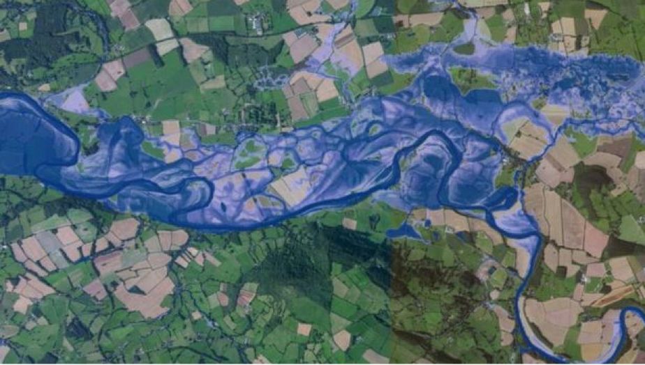
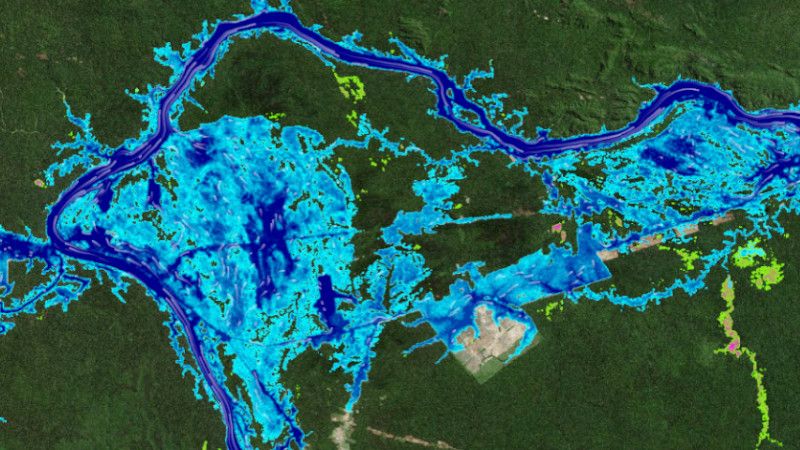
- Floodplain mapping to identify inundation zones
- Flood hazard analysis for risk zone delineation
The output of a flood model includes flood inundation mapping, flood vulnerability assessment reports, and visual GIS outputs that clearly communicate risk to decision-makers, engineers, and regulatory bodies.
Why is Flood Modelling Important?
India faces severe flood-related losses every monsoon season. From riverfront cities to agricultural plains and coastal zones, flood disaster management has become a national priority. A reliable flood model helps reduce these risks significantly across multiple sectors.
- Infrastructure Protection: Identifies flood-prone zones before highway, bridge, or building construction begins.
- Disaster Management Planning: Supports NDMA and state agencies in preparing evacuation routes and emergency response systems.
- Urban Drainage Management: Guides stormwater flood analysis and drainage network design in smart cities.
- Environmental Watershed Protection: Enables watershed flood modelling to protect river ecosystems and groundwater recharge zones.
- Regulatory Compliance: Supports Environmental Impact Assessment (EIA) submissions with scientific flood risk analysis documentation.
Methods Used in Flood Modelling
Our flood model workflow at Bhoojal Survey follows a structured, scientifically validated approach combining field investigation with advanced geospatial analysis:
GIS Flood Mapping
We use high-resolution satellite imagery, LiDAR data, and topographic surveys to create accurate GIS flood mapping outputs that identify floodplain boundaries and risk corridors.
Hydrological Watershed Analysis
Using rainfall data, catchment delineation, and land-use analysis, our hydrological flood model calculates runoff volumes, peak discharge, and time-to-peak for design flood events.
Hydraulic Flood Analysis
We apply industry-standard hydraulic models (HEC-RAS, MIKE FLOOD) to simulate river flood assessment under varying return periods — 10-year, 25-year, 50-year, and 100-year flood scenarios.
Terrain and Floodplain Analysis
Digital terrain processing identifies natural floodplain boundaries, enabling accurate flood inundation mapping and flood vulnerability assessment.
Hydrogeological Site Investigation
We conduct hydrogeological surveys using SSRMPATS Instrument, GER DETECT, and PQWT at site for open well/borewell location identification, which is critical for understanding sub-surface water behaviour during flood events.
Flood Forecasting Systems
We integrate real-time rainfall data, river gauge data, and hydrological models into flood forecasting systems that support early warning and disaster response planning.
Our advanced hydrological and geospatial survey solutions ensure every flood model we deliver is grounded in scientific flood investigation and analysis — not assumptions.
Applications of Flood Model Across Industries
Our flood model consultancy services are deployed across a wide range of sectors in India:
Smart City Projects Highway & Bridge Construction
River flood assessment and hydraulic flood analysis for safe bridge span design and road alignment.
Riverfront Development Environmental Impact Assessment
Environmental flood analysis for EIA reporting required under MoEF&CC; guidelines.
Watershed Management Government Flood Mitigation
Scientific flood analysis for dam safety, embankment design, and flood control infrastructure.
Mining & Industrial Projects
Flood risk assessment services to protect industrial assets and ensure safe operations near water bodies.
Why Choose Bhoojal Survey for Flood Model Services?
Bhoojal Survey is a trusted name in hydrological flood analysis consultancy across India. Here is why clients choose us for their flood modelling system requirements:
- Experienced Hydrological Experts: Our team brings deep knowledge in hydrological investigation, GIS flood mapping, and hydraulic flood analysis across diverse Indian terrains.
- Advanced Modelling Technologies: We use industry-standard tools — HEC-HMS, HEC-RAS, MIKE FLOOD, ArcGIS, QGIS — to deliver accurate flood prediction modelling outputs.
- Accurate Flood Risk Analysis: Every flood model we build is calibrated using observed data, ensuring reliable flood risk analysis for design and regulatory purposes.
- Professional Documentation: We prepare detailed flood hazard analysis reports, GIS maps, and flood vulnerability assessment documents suitable for government submissions and EIA reports.
- Pan-India Consultancy: From Himalayan river basins to coastal zones and Deccan plateau watersheds, our GIS flood mapping consultancy covers all hydro-climatic regions of India.
- Customized Solutions: We tailor every flood modelling system to the specific site conditions, project type, and client objectives.
Conclusion
A scientifically developed flood model is no longer a luxury for infrastructure projects — it is a regulatory necessity and a critical risk management tool. Whether you are planning a smart city, designing a highway through a floodplain, managing a river basin, or preparing an environmental impact assessment, accurate flood risk analysis protects your project, your investment, and communities.
Bhoojal Survey combines technical expertise, advanced GIS flood mapping, and on-ground hydrological investigation to deliver flood modelling services that are reliable, regulatory-compliant, and actionable. We work with government departments, infrastructure developers, environmental consultants, and disaster management agencies across India.
■ Contact Bhoojal Survey today for professional flood model consultancy, GIS flood mapping, and hydrological investigation services across India. Get accurate flood risk analysis for your next project.
Frequently Asked Questions (FAQs)
1. What is a flood model and how does it work?
A flood model is a computer-based hydrological and hydraulic simulation that predicts how water flows and accumulates across a landscape during rainfall or river overflow events. It uses terrain data, rainfall records, soil characteristics, and river geometry to calculate flood extent, depth, and velocity. The output is used for flood risk analysis, infrastructure planning, and disaster management. Bhoojal Survey delivers end-to-end flood modelling system services across India, from data collection and hydrological investigation to final GIS flood mapping outputs.
2. Why is flood risk analysis important for infrastructure projects in India?
India experiences severe monsoon flooding every year, causing significant damage to roads, bridges, buildings, and communities. Flood risk analysis using a scientific flood model ensures that infrastructure is designed to withstand design flood events — protecting both investment and public safety. For highway, smart city, riverfront, and industrial projects, flood hazard analysis is often mandatory under environmental clearance and regulatory frameworks governed by agencies such as the Central Water Commission (CWC) and the National Disaster Management Authority (NDMA).
3. Which industries require flood modelling services in India?
Flood modelling services are essential for a wide range of industries across India, including urban infrastructure and smart city development, highway and bridge construction, riverfront real estate and tourism projects, mining and industrial facilities near water bodies, agricultural watershed management, environmental impact assessment consultancy, and government irrigation and flood control departments. Bhoojal Survey provides customized flood model and flood risk assessment services to all these sectors with pan-India coverage.
4. How accurate are flood prediction models?
The accuracy of a flood prediction model depends on the quality of input data, including terrain resolution, rainfall records, soil data, and river discharge measurements. Well-calibrated flood models validated against historical flood events can predict flood extents with high confidence — typically within acceptable engineering tolerances for design purposes. At Bhoojal Survey, we use high-resolution DEMs, satellite data, and on-ground hydrogeological survey data to ensure our flood modelling system delivers scientifically reliable results for every project.
5. How do I get professional flood model consultancy services for my project in India? Getting professional flood modelling services from Bhoojal Survey is simple. Contact our team with your project details — location, type, and scope. Our hydrological experts will assess your requirements and propose a customized flood model solution covering GIS flood mapping, hydrological investigation, hydraulic flood analysis, and flood risk assessment reporting. We serve government departments, developers, environmental consultants, and disaster management agencies across all states of India.