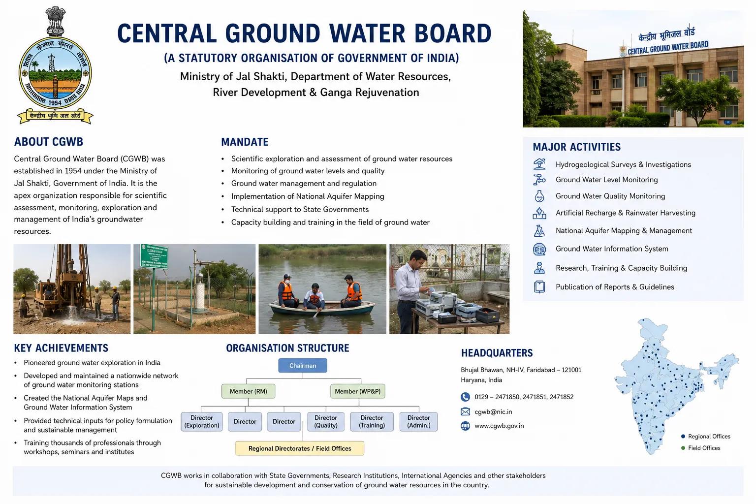
Central Ground Water Board:
India's groundwater resources are under immense pressure. Rapid urbanisation, agricultural expansion, and industrial growth have pushed aquifer systems in many parts of the country to critical levels. At the centre of India's national response to this challenge stands the Central Ground Water Board — the apex technical body responsible for scientific assessment, monitoring, and management of the country's groundwater resources.
For industries, infrastructure developers, agricultural planners, and environmental consultants working on groundwater-dependent projects across India, understanding the role and outputs of the Central Ground Water Board is not optional — it is foundational to responsible and compliant project planning.
What is the Central Ground Water Board?
The Central Ground Water Board, commonly known as CGWB, is a premier national organisation under the Ministry of Jal Shakti, Government of India. Established in 1970, it functions as the scientific and technical arm of the government for all matters related to groundwater resource assessment, development, and conservation across the country.
CGWB operates through regional offices spread across India, covering diverse hydrogeological settings — from the alluvial plains of the Ganga basin to the hard rock terrains of the Deccan Plateau and the arid zones of Rajasthan. Its mandate is to provide authoritative, data-driven guidance on groundwater availability, quality, and sustainability at the national and regional scale.
The Board publishes annual groundwater assessment reports at the district and assessment unit level, which form the regulatory basis for groundwater extraction approvals, CGWA NOC requirements, and resource planning decisions across the country.
Role of the Central Ground Water Board in Groundwater Management
The CGWB plays a multi-dimensional role in ensuring India's groundwater is managed scientifically and sustainably:
National Groundwater Monitoring: CGWB operates one of the largest groundwater monitoring networks in the world, with thousands of observation wells across India measuring seasonal water level fluctuations, long-term trends, and aquifer stress indicators.
Aquifer Mapping Programme: Under the National Aquifer Mapping and Management Programme (NAQUIM), CGWB has systematically mapped aquifer systems across India to characterise their geometry, hydraulic properties, and groundwater potential — providing the scientific basis for local groundwater management plans.
Groundwater Resource Assessment: CGWB conducts periodic joint assessments with State Ground Water Departments to classify assessment units as safe, semi-critical, critical, or over-exploited — directly determining where groundwater extraction is regulated or restricted.
Water Conservation and Recharge Guidance: CGWB provides technical guidelines for artificial groundwater recharge, rainwater harvesting structures, and watershed-based conservation measures tailored to different hydrogeological settings.
Technical Support for Policy and Planning: Central and state government agencies, infrastructure planners, and irrigation departments rely on CGWB data and studies to make investment and policy decisions related to water resource planning and management.
Studies and Investigations Conducted by CGWB
The Central Ground Water Board undertakes a comprehensive range of scientific investigations that directly benefit project developers and planners:
Hydrogeological Investigations: Systematic mapping of subsurface geology, aquifer characteristics, and groundwater potential zones across districts and river basins.
Groundwater Exploration: CGWB identifies and evaluates groundwater-bearing formations through exploratory drilling, geophysical surveys, and test pumping in data-scarce regions.
Groundwater Quality Monitoring: National-level water quality surveys track contamination trends — fluoride, arsenic, nitrate, and other parameters — across aquifer systems, supporting safe water supply planning.
Groundwater Recharge Studies: Scientific studies on natural and artificial recharge quantify the replenishment potential of aquifers under current and projected climate conditions.
At Bhoojal Survey, our field operations complement and build upon CGWB frameworks. Our teams conduct hydrogeological surveys using SSRMPATS Instruments, GER DETECT, and PQWT at site for precise open well and borewell location identification. These advanced groundwater and geophysical survey solutions, integrated with scientific groundwater investigation and analysis, ensure our clients receive project-level assessments that align fully with CGWB data standards and regional hydrogeological findings.
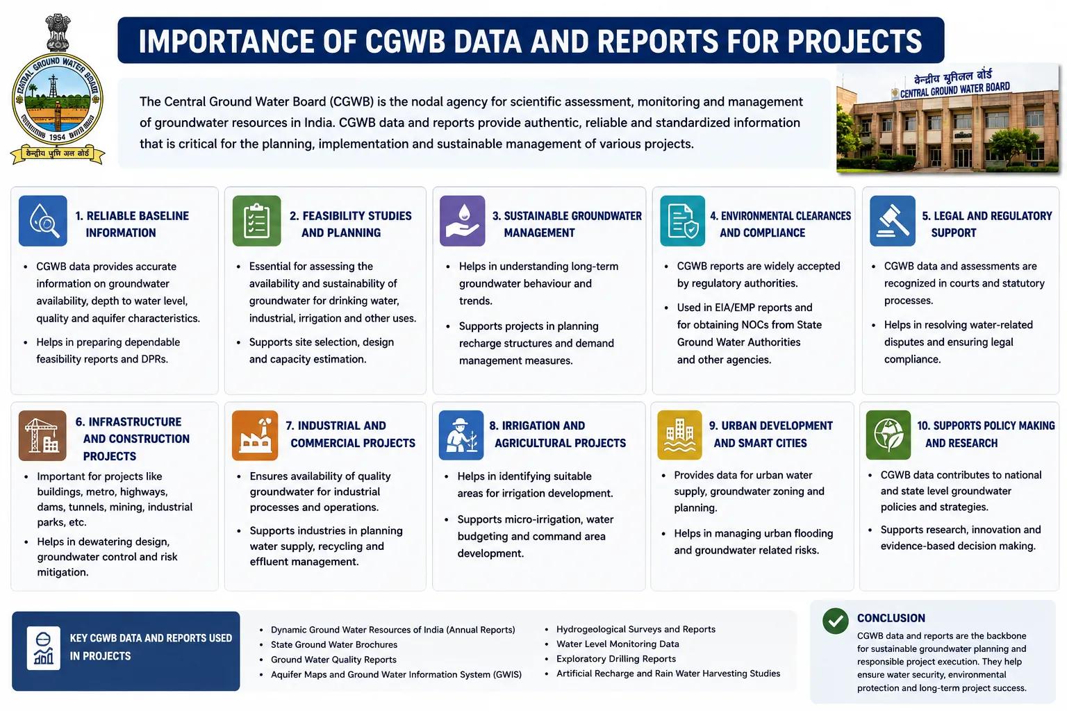
Importance of CGWB Data and Reports for Projects
CGWB reports and groundwater assessment data carry direct practical and regulatory significance for project developers across India:
Borewell Development: CGWB groundwater potential zone maps and district-level reports guide borewell siting decisions, reducing drilling failures and improving yield reliability.
Industrial Groundwater Assessment: Factories and processing units must align their groundwater extraction proposals with CGWB's assessment unit classifications to obtain CGWA NOC approvals.
Infrastructure and Real Estate Planning: CGWB hydrogeological data informs foundation design, dewatering planning, and groundwater impact assessments for large construction projects.
Agricultural Irrigation Projects: Irrigation planners use CGWB seasonal water level data and recharge estimates to design sustainable tube well irrigation schemes and avoid aquifer overexploitation.
Environmental Impact Assessments: EIA reports for Category A and B projects require groundwater baseline data sourced from or validated against CGWB monitoring records and published assessments.
Why Choose Bhoojal Survey for Groundwater Consultancy
Bhoojal Survey is a trusted hydrogeological investigation company in India, delivering professional groundwater survey services that work hand-in-hand with CGWB frameworks and regulatory requirements:
- Senior hydrogeologists with field experience across diverse Indian geological terrains
- Advanced geophysical instruments for high-accuracy subsurface groundwater mapping
- CGWB-aligned reporting standards for compliance-ready documentation
- Complete consultancy support for CGWA NOC applications and groundwater assessments
- Pan-India project execution capability across industrial, agricultural, mining, and infrastructure sectors
- Customised groundwater management solutions designed around client project needs and site-specific hydrogeological conditions
Conclusion
The Central Ground Water Board is the scientific foundation upon which responsible groundwater management in India rests. Its monitoring data, aquifer mapping programmes, and resource assessments provide the authoritative reference framework for every major groundwater decision in the country — from regulatory approvals to infrastructure investment.
For project developers and planners who need to translate national CGWB data into site-specific groundwater action, professional consultancy support makes all the difference. Bhoojal Survey bridges that gap — combining CGWB's national science with rigorous field investigation and practical project guidance.
📞 Contact Bhoojal Survey today to discuss your groundwater assessment, hydrogeological investigation, or CGWA compliance requirements — backed by science, delivered with expertise.
Frequently Asked Questions (FAQs)
Q1. What is the Central Ground Water Board? The Central Ground Water Board is India's national apex technical authority for groundwater resource assessment, monitoring, and management. It operates under the Ministry of Jal Shakti and publishes groundwater assessment reports, aquifer maps, and water quality data used for project planning and regulatory decisions across India.
Q2. What are the main functions of CGWB? CGWB's core functions include national groundwater level monitoring, aquifer mapping under the NAQUIM programme, periodic groundwater resource assessment with state agencies, groundwater quality surveys, artificial recharge studies, and providing technical guidance for sustainable groundwater development and conservation.
Q3. How does CGWB support groundwater management in India? CGWB supports groundwater management by classifying assessment units as safe, semi-critical, critical, or over-exploited based on extraction and recharge data. This classification directly regulates where groundwater can be freely developed and where CGWA permissions are required, helping prevent aquifer depletion across the country.
Q4. Why is CGWB data important for borewell and industrial projects? CGWB groundwater potential zone maps, seasonal water level data, and district-level assessment reports guide borewell siting, depth estimation, and yield planning. Industrial units must also align extraction proposals with CGWB assessment classifications to meet CGWA NOC requirements and environmental compliance conditions.
Q5. Does Bhoojal Survey work in alignment with CGWB standards? Yes. Bhoojal Survey's hydrogeological investigations, geophysical surveys, and groundwater assessment reports are prepared in alignment with CGWB data frameworks and documentation standards. This ensures our reports are technically credible, regulatory-ready, and consistent with national groundwater science benchmarks.