Introduction
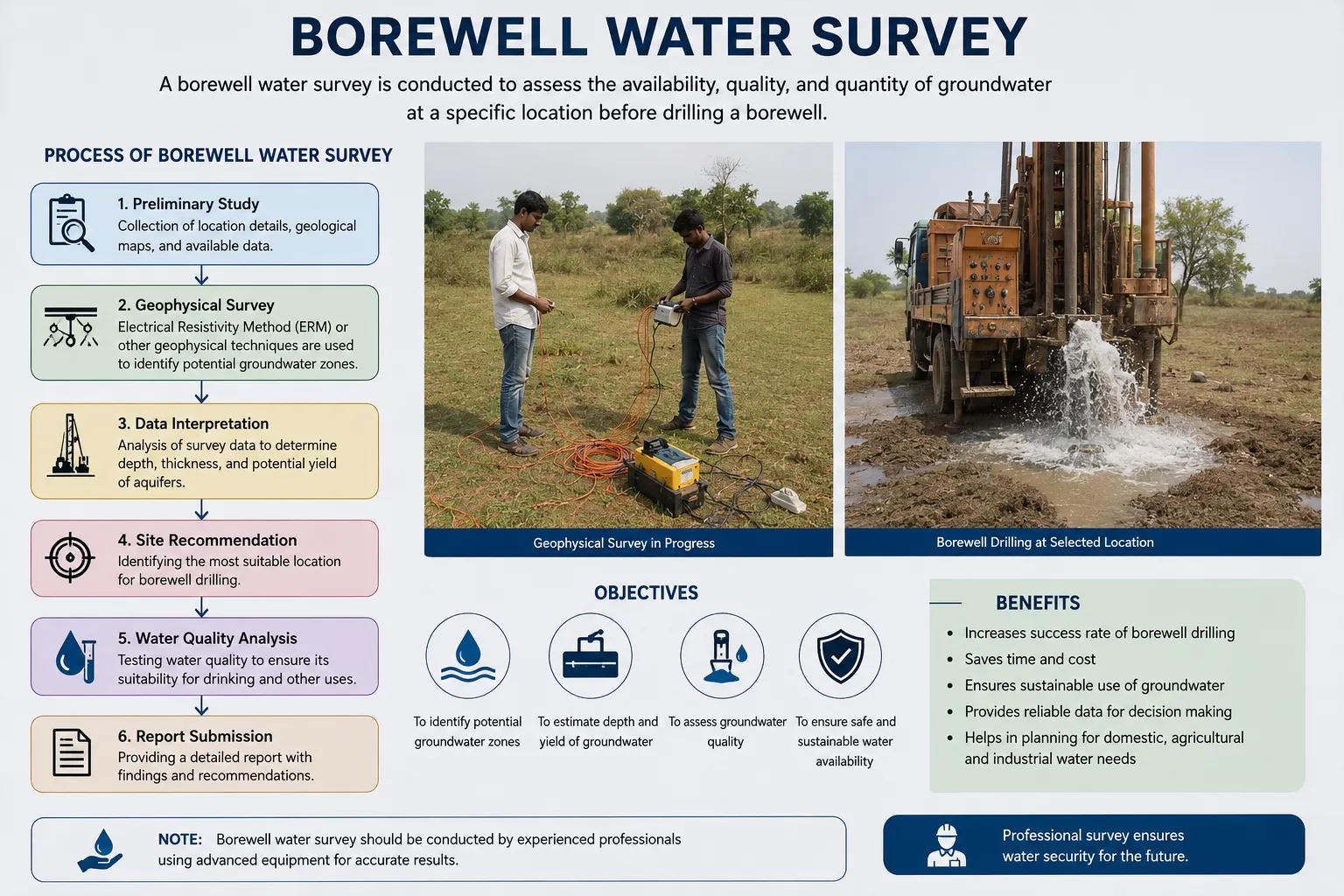
A borewell water survey is a scientific investigation conducted to identify the most suitable location for drilling a borewell — before any drilling begins. It combines hydrogeological analysis, geophysical survey techniques, and field investigation to determine where groundwater exists, at what depth, and in what quantity.
Drilling a borewell without a proper survey is one of the most common and costly mistakes landowners, farmers, and project developers make. A dry borewell or a low-yield borewell wastes time, money, and resources. A professional borewell water survey eliminates guesswork and significantly improves the chances of striking a productive water source.
For agriculture, industry, construction, and rural water supply projects across India, scientific groundwater assessment before drilling is not just good practice — it is essential.
What is Borewell Water Survey
A borewell water survey is a systematic hydrogeological and geophysical investigation carried out to locate underground water-bearing zones — called aquifers — within a specific area.
The survey evaluates:
- Subsurface geological conditions
- Depth and thickness of aquifer layers
- Groundwater potential and expected yield
- Best drilling location and recommended depth
The goal is to give the client accurate, data-backed guidance so that the borewell is drilled at exactly the right spot — maximizing success and minimizing cost. Without this investigation, borewell drilling becomes little more than an expensive gamble.
Methods Used in Borewell Water Survey
Professional borewell water surveys use a combination of scientific techniques depending on the geology of the area:
Hydrogeological Investigation Analysis of the area's rock formations, soil types, and natural drainage patterns to understand how and where groundwater accumulates.
Electrical Resistivity Survey One of the most reliable geophysical methods — it measures how rocks and soils resist electrical current. Water-bearing zones show distinctly different resistivity values, allowing precise aquifer identification.
Geological Mapping Surface geological features such as lineaments, fractures, and rock outcrops are mapped to identify structural zones that typically hold groundwater.
Satellite and GIS Analysis Remote sensing data and GIS mapping help identify recharge zones, drainage networks, and subsurface geological structures that indicate groundwater potential.
Groundwater Potential Assessment Integrating all data to produce a groundwater potential map that highlights the best borewell locations within the survey area.
Benefits of Conducting a Borewell Water Survey
The advantages of a proper borewell water survey extend well beyond just finding water:
- Higher borewell success rate — scientific site selection dramatically reduces the risk of drilling a dry or low-yield borewell
- Reduced drilling costs — knowing the correct depth and location avoids wasted drilling in unproductive zones
- Better groundwater yield estimation — survey data provides realistic expectations of water output before drilling begins
- Scientific site selection — decisions are based on data, not assumptions or traditional methods
- Sustainable groundwater development — responsible aquifer identification helps prevent over-extraction and long-term depletion
Professional teams carry out advanced groundwater and geophysical survey solutions at the field level — including conducting hydrogeological surveys using SSRMPATS Instrument, GER DETECT, and PQWT at site for open well and borewell location identification. This scientific groundwater investigation and analysis ensures that the survey results are technically reliable and practically actionable.
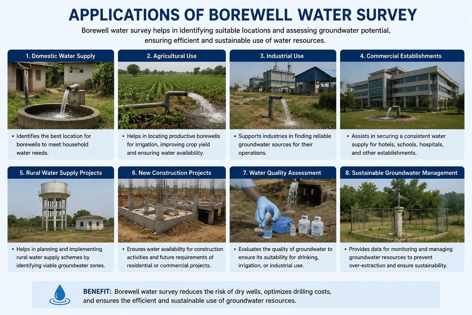
Borewell water surveys serve a wide range of sectors and project types across India:
- Agricultural irrigation projects — ensuring reliable water supply for farming operations and reducing dependence on erratic rainfall
- Industrial water supply systems — identifying sustainable groundwater sources for manufacturing, processing, and cooling operations
- Residential and real estate developments — securing dependable water supply for housing projects in areas without municipal connections
- Infrastructure projects — highways, tunnels, and large construction sites requiring on-site water availability
- Mining operations — assessing groundwater conditions before dewatering or site development
- Government rural water schemes — supporting Jal Jeevan Mission and other national programs that depend on borewell-based water supply in villages
In each of these applications, the borewell water survey is the foundation — the scientific starting point that makes everything else more efficient and more reliable.
Why Choose Bhoojal Survey
Bhoojal Survey is a leading professional groundwater consultancy specializing in borewell water surveys and hydrogeological investigations across India. We offer:
- Experienced hydrogeologists and geophysical survey specialists
- Advanced groundwater survey instruments including resistivity meters and geophysical detection equipment
- Accurate, data-driven borewell location identification with high success rates
- Detailed technical survey reports with depth recommendations and yield estimates
- Pan-India survey coverage — rural, urban, agricultural, and industrial sites
- Customized groundwater solutions tailored to each client's specific water requirement and geological conditions
Our approach combines field expertise with scientific rigour — giving clients the confidence to drill in the right place, at the right depth, for the right reasons.
Conclusion
A borewell water survey is the smartest investment anyone can make before drilling. It replaces uncertainty with scientific evidence, reduces costs, improves success rates, and supports sustainable groundwater use.
Whether you are a farmer looking for irrigation water, an industry planning its water supply, or a developer securing water for a new project — professional hydrogeological and geophysical investigation is the foundation of a successful borewell.
Contact Bhoojal Survey today for expert borewell water survey services, groundwater investigation, and scientific aquifer assessment anywhere across India.
Frequently Asked Questions (FAQs)
Q1. What is a borewell water survey? A borewell water survey is a scientific investigation using hydrogeological and geophysical methods to identify the best location, depth, and expected yield for drilling a borewell before any drilling begins.
Q2. Why is a groundwater survey important before drilling a borewell? Without a survey, borewell drilling is based on guesswork and carries a high risk of failure. A scientific borewell water survey identifies productive aquifer zones, reducing the chance of drilling a dry or low-yield borewell.
Q3. Which methods are used in borewell water surveys? Key methods include electrical resistivity survey, hydrogeological investigation, geological mapping, satellite and GIS analysis, and integrated groundwater potential assessment.
Q4. How accurate is a borewell water survey? When conducted by experienced professionals using advanced geophysical instruments, borewell water surveys are highly accurate. They significantly improve drilling success rates compared to unsurveyed drilling.
Q5. How long does a borewell water survey take? A standard borewell water survey typically takes one to three days depending on the size of the area and the complexity of the geology. The final technical report is usually delivered within a few days after field investigation.