Water is not just a resource — it is the backbone of every infrastructure, agricultural, and industrial project in India. Before a single borewell is drilled, before a single pump is installed, there is a critical step that determines success or failure: the hydrogeological survey.
A hydrogeological survey is a scientific investigation of the subsurface to map groundwater availability, aquifer depth, water table conditions, and geological formations that control underground water movement. It eliminates guesswork from borewell drilling and replaces it with data-driven decisions.
For electrical contractors, EPC companies, solar plant developers, mining companies, and government infrastructure projects across India, an accurate groundwater survey is not optional — it is essential. Whether you need water for industrial operations, site construction, irrigation, or long-term supply planning, understanding what lies beneath the surface is the starting point.
At Bhoojal Survey, we combine advanced geophysical instruments, field expertise, and scientific interpretation to deliver reliable hydrogeological investigation and groundwater resource assessment services across India.
1. What is a Hydrogeological Survey?
A hydrogeological survey is a systematic field investigation that studies the relationship between geology, soil formations, and groundwater presence in a specific area. It combines hydrogeology — the science of water movement within the earth — with geophysical techniques to identify subsurface water-bearing zones called aquifers.
In simple terms, it answers three critical questions before you drill a borewell:
- Is groundwater present at this location?
- At what depth does a productive aquifer exist?
- What quantity and quality of water can be sustainably extracted?
The hydrogeological investigation process involves geological mapping, electrical resistivity testing, geophysical survey methods, and subsurface layer analysis — all interpreted together to produce a scientific groundwater report that guides project decisions.
Unlike traditional water-divining practices, a professional hydrogeological survey uses calibrated instruments, validated field data, and established scientific standards to deliver results you can rely on.
2. Why Hydrogeological Surveys are Important
India faces a complex groundwater challenge. Overextraction, seasonal variation, irregular recharge patterns, and geological diversity make groundwater availability highly site-specific. What works 2 km away may not work at your project site.
This is precisely why a professional groundwater survey is critical before any borewell drilling or water extraction project. Here is why:
- Accurate aquifer identification prevents drilling dry borewells, saving substantial cost and time.
- Subsurface water study reveals the exact depth and thickness of water-bearing zones for optimal borewell design.
- Groundwater availability analysis enables long-term water resource planning for industries and urban projects.
- Underground water detection reduces exploration risk in hard rock terrain, alluvial plains, and fractured geology.
- Water table analysis supports groundwater recharge study planning to ensure sustainable extraction.
- Borewell site identification through scientific methods improves success rate compared to conventional guesswork.
For large-scale projects — solar plants, substations, mining operations, airports, or smart city developments — groundwater surveys directly impact operational readiness, project timelines, and budget management.
3. Applications of Hydrogeological Survey
The value of a hydrogeological investigation extends far beyond simple borewell drilling. Here are the key applications across industries in India:
Borewell and Open Well Site Selection
The most common application. Scientific groundwater potential mapping ensures borewells are drilled at locations with highest probability of water yield, saving time and drilling costs.
Industrial and Infrastructure Projects
Solar power plants, substations, data centres, and manufacturing facilities require reliable water sources. A groundwater exploration study identifies sustainable supply points that support long-term operations.
Agriculture and Irrigation Projects
Farmers, agro-industries, and irrigation projects use groundwater investigation to plan tube wells and irrigation systems with accurate knowledge of aquifer depth and recharge conditions.
Mining Operations
Mining companies conduct hydrogeological surveys to understand subsurface water conditions before excavation — preventing unexpected groundwater inflows, planning dewatering systems, and assessing water impact on operations.
Smart City and Urban Development
Urban planners and municipal bodies use subsurface geological analysis to manage groundwater resources, plan recharge zones, and ensure water security for growing urban populations.
Government Water Resource Programs
State and central government departments use groundwater resource assessment and aquifer mapping services to develop water management plans, watershed projects, and drinking water supply schemes across rural India.
Telecom Towers and Remote Installations
Remote telecom infrastructure and off-grid installations require local water sources for construction and maintenance. Hydrogeological surveys identify viable borewell locations even in geologically challenging areas.
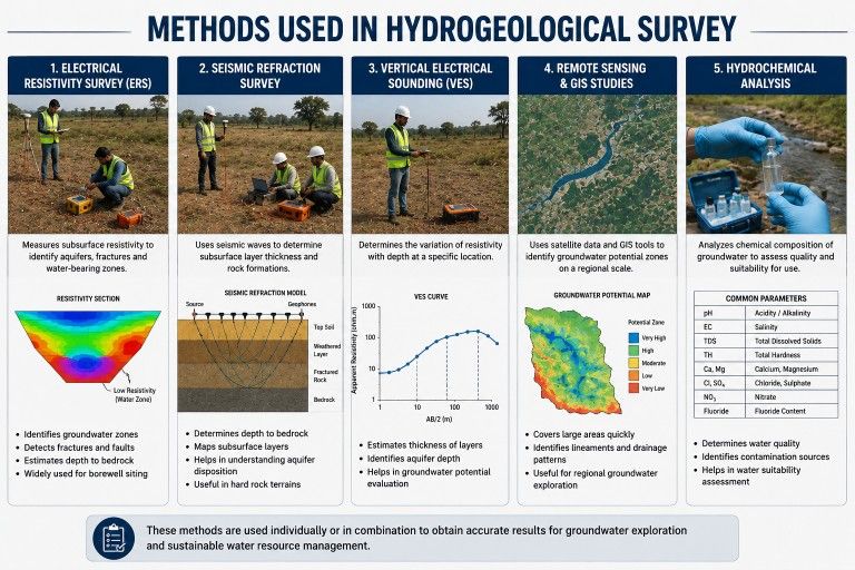
4. Methods Used in Hydrogeological Survey
Professional hydrogeological survey services use a combination of proven geophysical methods. Each technique contributes to a comprehensive picture of the subsurface.
Electrical Resistivity Survey
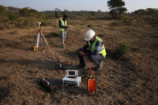
This is the most widely used and reliable method in groundwater exploration. It works on the principle that different geological materials — rock, soil, clay, water-bearing formations — have different electrical resistivity values.
Survey teams drive current into the ground through electrodes and measure the resulting voltage at varying depths. The resistivity data is then processed to generate a subsurface layer model showing where water-saturated zones exist.
Low resistivity zones typically indicate the presence of saturated aquifers — pointing to productive borewell locations. High resistivity zones indicate dry rock or unfractured formations.
This method is particularly effective in hard rock terrain, alluvial plains, and coastal aquifer systems — conditions commonly encountered across India's diverse geology.
Geophysical Survey Methods
Beyond resistivity, trained hydrogeologists use seismic refraction, electromagnetic surveys, and vertical electrical sounding (VES) techniques to map geological structure, identify subsurface layer sequences, and detect underground water-bearing fractures.
These methods enable accurate underground water detection at depths ranging from 20 metres to over 200 metres depending on site conditions and project requirements.
Remote Sensing and GIS Mapping
For large-area groundwater potential mapping, satellite remote sensing data combined with GIS analysis provides valuable geological mapping support. Land use, drainage patterns, geological lineaments, and soil classifications are analysed to identify groundwater potential zones before field investigation begins.
This reduces the overall survey time and focuses field effort on the most promising areas for detailed hydrogeological investigation.
5. Equipment and Instruments Used
Professional groundwater detection services rely on precision instruments that deliver accurate subsurface data. At Bhoojal Survey, our field teams operate using advanced hydrogeological survey instruments including:
- Electrical Resistivity Meter — for soil and rock resistivity measurement and aquifer mapping
- GPS Mapping Tools — for precise survey location recording and report mapping
- Geophysical Survey Equipment — multi-electrode arrays for deep subsurface profiling
- Data Logging Systems — real-time field data capture and processing
- Groundwater Detection Instruments — advanced sensors for water table analysis
FIELD NOTE
Bhoojal Survey conducts hydrogeological surveys using SSRMPATS Instrument, GER DETECT, and PQWT at site for open well / borewell location — enabling highly accurate aquifer identification and groundwater zone mapping in challenging geological conditions across India.
Our advanced groundwater and geophysical survey solutions are calibrated for India's diverse geological settings — from hard rock Deccan traps to alluvial Indo-Gangetic plains, coastal sediments, and fractured granite terrain.
Every instrument is field-tested, regularly calibrated, and operated by trained hydrogeological professionals with hands-on experience across hundreds of survey sites.
6. Factors Affecting Groundwater Availability
Understanding why groundwater is unevenly distributed helps explain why site-specific hydrogeological surveys are essential. Several geological and environmental factors control water availability:
- Geological formations — rock type, porosity, and fracture density determine how much water a formation can hold and transmit.
- Soil and rock permeability — sandy, alluvial soils have high permeability, while clay-rich formations restrict water movement.
- Aquifer depth and structure — confined and unconfined aquifers behave differently in terms of pressure, yield, and recharge.
- Rainfall and recharge conditions — seasonal rainfall directly influences groundwater recharge study requirements and long-term water table analysis.
- Groundwater table fluctuations — water tables rise during monsoon and drop during dry seasons, requiring dynamic resource assessment.
- Human water extraction — over-extraction from existing borewells and wells affects surrounding groundwater availability significantly.
A comprehensive subsurface water investigation accounts for all these factors, ensuring that borewell location recommendations and groundwater development plans are based on complete scientific data — not assumptions.
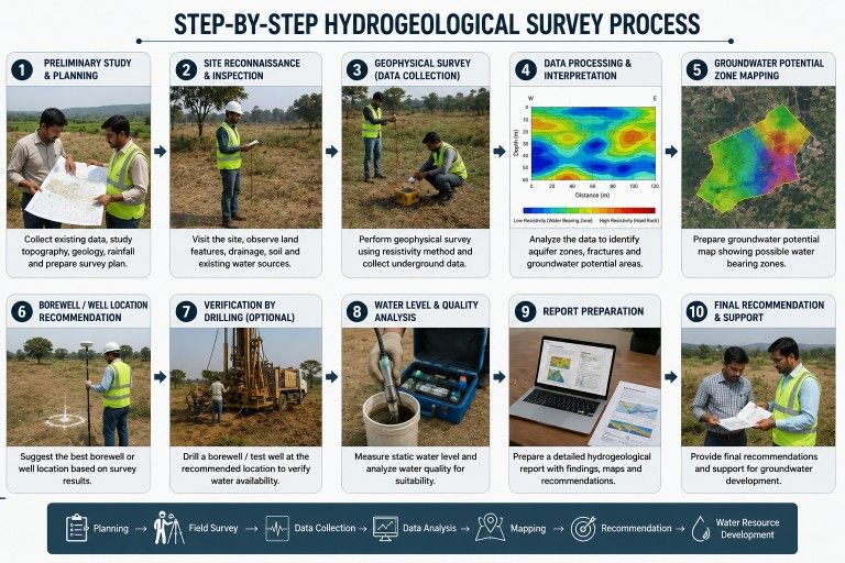
7. Step-by-Step Hydrogeological Survey Process
Our scientific groundwater investigation and subsurface analysis follows a structured workflow to ensure accuracy and reliability at every stage:
- Site Inspection and Preliminary Study — Field team visits the site, reviews existing geological maps, local borewell data, and identifies survey objectives.
- Hydrogeological Data Collection — Collection of regional hydrogeology data, aquifer characteristics, local water table records, and seasonal groundwater trends.
- Survey Planning and Equipment Setup — Selection of appropriate geophysical methods, electrode configurations, and measurement profiles based on site geology.
- Electrical Resistivity / Geophysical Testing — Conducting field measurements using calibrated instruments across planned survey profiles.
- Field Data Collection and Analysis — Real-time data logging, quality checks, and initial interpretation of resistivity or geophysical readings.
- Subsurface Layer Interpretation — Processing of field data to generate subsurface models, cross-sections, and aquifer zone identification.
- Groundwater Potential Assessment — Scientific evaluation of water-bearing zones, estimated depth, probable yield, and seasonal reliability.
- Borewell Location Recommendation — Site-specific borewell location marking with GPS coordinates and recommended drilling depth.
- Technical Report Preparation — Detailed hydrogeological survey report with survey data, interpretation, aquifer maps, and recommendations.
- Groundwater Development Recommendations — Advisory on borewell design, pump selection, sustainable extraction limits, and monitoring requirements.
8. Benefits of Professional Hydrogeological Survey Services
Investing in a professional hydrogeological survey before borewell drilling delivers measurable returns:
- Higher borewell success rate — scientific site selection dramatically reduces the probability of dry or low-yield borewells.
- Cost savings — avoiding failed boreholes and re-drilling eliminates significant unnecessary expenditure.
- Informed groundwater resource assessment — accurate data supports long-term water supply planning for industrial, commercial, and agricultural needs.
- Risk mitigation — subsurface analysis prevents unexpected geological surprises during drilling in complex terrain.
- Sustainable water management — proper groundwater monitoring and yield estimates prevent over-extraction and support aquifer health.
- Regulatory confidence — survey reports provide documented evidence for groundwater permits and environmental clearances.
- Project readiness — timely survey completion enables smooth project scheduling for EPC contractors and infrastructure developers.
9. Why Choose Bhoojal Survey
Trusted Hydrogeological Survey Company Across India
Bhoojal Survey is a professional hydrogeological consultancy providing scientific groundwater investigation and subsurface analysis services for industrial, agricultural, and infrastructure projects across India.
Here is what sets our hydrogeological survey services apart:
- Experienced Hydrogeologists — Our survey team brings deep expertise in aquifer identification, geological mapping, and groundwater exploration across India's varied terrain.
- Advanced Instruments — We use internationally recognised groundwater detection instruments including SSRMPATS, GER DETECT, and PQWT for maximum survey accuracy.
- Pan-India Service Coverage — From Gujarat and Rajasthan to Maharashtra, Andhra Pradesh, Karnataka, Madhya Pradesh, and beyond — our field teams operate nationwide.
- Industrial Project Expertise — We serve electrical contractors, solar plant companies, EPC contractors, mining companies, telecom projects, and government infrastructure programs.
- Accurate Borewell Location Services — Our borewell site survey services have consistently delivered high-yield borewell locations across diverse geological settings.
- Fast Turnaround and Detailed Reports — Scientific field reports with GPS-referenced borewell recommendations, subsurface profiles, and groundwater development guidance.
- Transparent and Professional — We believe in clear communication, scientifically backed data, and honest assessments — no guesswork, no unrealistic promises.
CTA
Need a hydrogeological survey for your project? Contact Bhoojal Survey today for a professional consultation. Visit www.bhoojalsurvey.com or call our expert team for groundwater survey services, borewell location services, and hydrogeological investigation services across India.
10. Conclusion
Groundwater is a finite and often misunderstood resource. Drilling a borewell without a hydrogeological survey is like building a structure without a soil investigation — the risk of failure is real, the cost of failure is high.
A professional hydrogeological survey gives you scientific certainty before you invest in drilling, pumping infrastructure, or water supply systems. It maps what lies beneath, identifies where productive aquifers exist, and provides a technical foundation for every groundwater decision your project requires.
Whether you are planning a solar plant in Rajasthan, a substation in Maharashtra, a mining operation in Jharkhand, or an urban development project in Karnataka — Bhoojal Survey brings the field experience, advanced instruments, and technical expertise to deliver reliable groundwater exploration services you can trust.
Let science guide your groundwater decisions. Contact Bhoojal Survey for accurate, professional, and affordable hydrogeological survey services across India.
Frequently Asked Questions (FAQs)
Q: What is a hydrogeological survey?
A: A hydrogeological survey is a scientific field investigation that studies subsurface geology and groundwater conditions to identify aquifer locations, water table depth, and groundwater availability. It uses geophysical methods — primarily electrical resistivity testing — to map underground water-bearing zones before borewell drilling.
Q: How does a hydrogeological survey help in borewell location?
A: It precisely identifies the best drilling location by detecting productive aquifers, estimating groundwater depth, and mapping subsurface geology. This significantly reduces the risk of dry borewells and ensures optimal water yield from every borewell drilled.
Q: Which methods are used in hydrogeological surveys?
A: Professional hydrogeological surveys use electrical resistivity surveys, vertical electrical sounding (VES), geophysical profiling, electromagnetic methods, and remote sensing / GIS mapping. These methods are selected based on site geology and project requirements.
Q: How long does a hydrogeological survey take?
A: A standard single-site hydrogeological survey typically takes 1 to 3 days depending on site size, terrain complexity, and number of profiles required. The detailed technical report is usually delivered within 3 to 7 working days after field investigation.
Q: What equipment is used in groundwater surveys?
A: Professional groundwater surveys use electrical resistivity meters, SSRMPATS instruments, GER DETECT systems, PQWT groundwater detectors, GPS mapping tools, geophysical survey arrays, and advanced data logging equipment for accurate subsurface analysis.
Q: Why is a hydrogeological survey important before drilling a borewell?
A: Without a survey, borewell drilling is essentially guesswork — leading to dry holes, wasted resources, and project delays. A hydrogeological survey delivers scientific data on aquifer depth, water yield potential, and the best drilling location — saving time and significant cost.
Q: What industries need hydrogeological survey services?
A: Hydrogeological surveys are essential for solar power plants, EPC contractors, mining companies, substations, telecom projects, airports, government infrastructure, agricultural irrigation projects, urban development, and any industry requiring reliable groundwater supply.
Q: Does Bhoojal Survey provide services across India?
A: Yes. Bhoojal Survey provides pan-India hydrogeological survey services, groundwater exploration services, borewell location surveys, and geophysical investigation across all major states including Maharashtra, Gujarat, Rajasthan, Madhya Pradesh, Karnataka, Andhra Pradesh, and beyond.