When engineers, contractors, and infrastructure planners need to understand what lies beneath the ground before excavation begins, they rely on one technology above all others — GPR Survey. But what is the GPR survey full form? GPR stands for Ground Penetrating Radar, and a GPR survey is a cutting-edge, non-destructive geophysical investigation method that detects and maps underground utilities, structures, and anomalies without a single spade of soil being removed.
Whether you are working on a smart city project in Pune, a metro rail corridor in Mumbai, a highway construction site in Madhya Pradesh, or an airport expansion anywhere across India, GPR survey technology is the safest and most accurate method to detect underground pipelines, cables, voids, and structural features before ground-breaking activities begin.
Ground Penetrating Radar survey is now a standard requirement across infrastructure, construction, mining, and utility sectors in India — making professional GPR survey services an indispensable part of any responsible project plan.
What is the Full Form of GPR Survey?
The full form of GPR is Ground Penetrating Radar. A GPR survey, therefore, refers to a geophysical radar survey that uses high-frequency electromagnetic waves to penetrate the ground and capture reflected signals from subsurface objects and layers.
In simple terms, GPR survey meaning = using radar technology to see underground — much like a
medical X-ray reveals what is inside the human body, a GPR scan reveals what lies beneath the earth's surface without any destructive digging.
- GPR Full Form: Ground Penetrating Radar
- Survey Type: Non-destructive geophysical investigation
- Primary Use: Underground utility detection and subsurface mapping
- Industry Standard: Global and India-wide adoption in infrastructure projects
What is a GPR Survey?
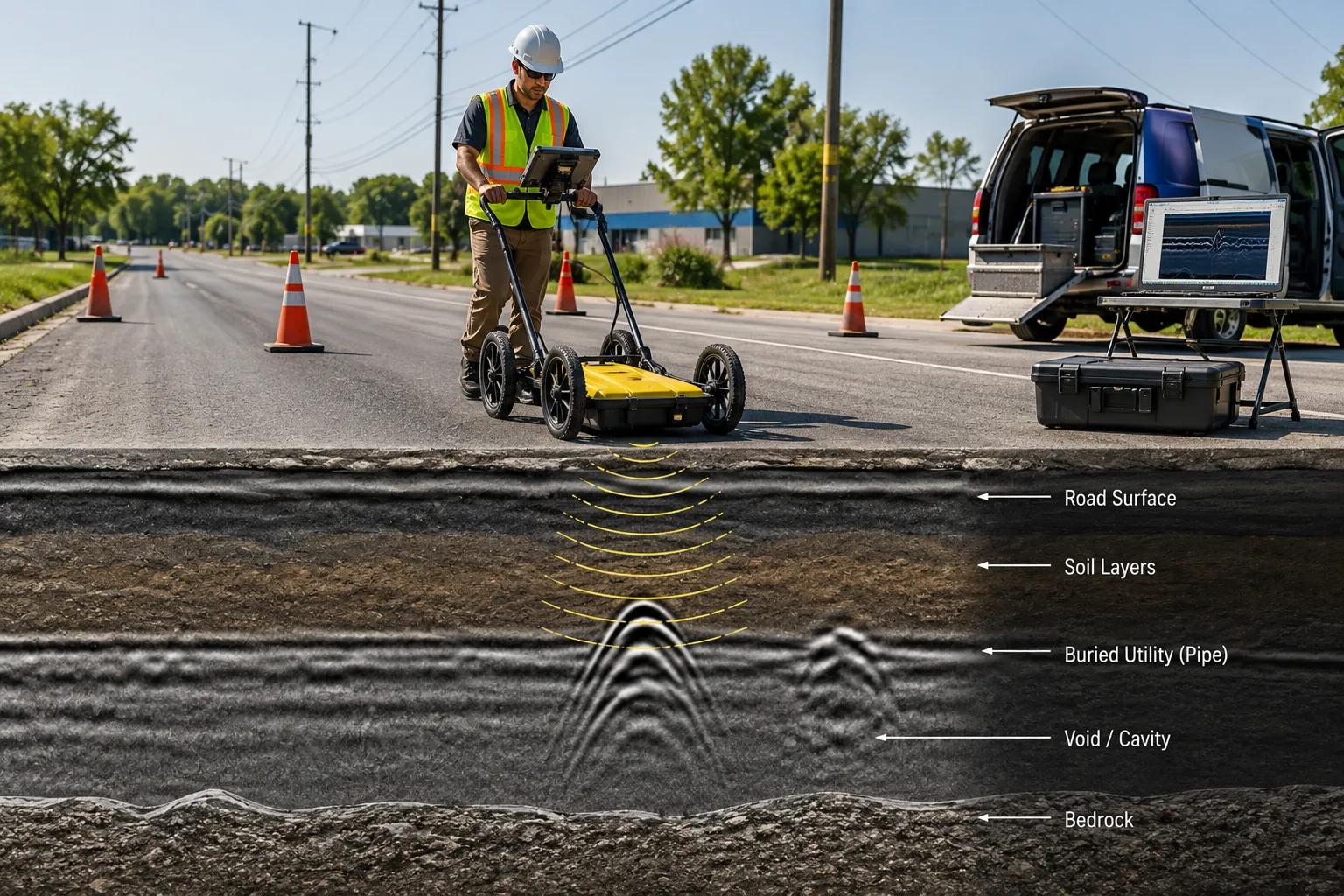
A Ground Penetrating Radar survey is a scientific, non-invasive underground investigation technique. It works by transmitting short pulses of electromagnetic energy into the ground through a surface antenna. When these radar waves hit a buried object — a pipe, cable, void, or geological feature — they reflect back to the surface. The receiver unit captures these return signals and converts them into a visual subsurface profile, commonly called a radargram.
This radargram allows trained geophysical survey experts to identify the position, depth, and nature of underground utilities and structures with high precision, making GPR scanning services far superior to traditional trial-pit excavation methods.
Why GPR Survey is Important for Modern Infrastructure Projects
India is experiencing an unprecedented infrastructure boom — smart cities, metro rail corridors, national highway expansion, industrial estates, and utility network upgrades are creating massive demand for reliable underground utility mapping services. Without knowing what lies underground, construction companies face serious risks:
■ Accidental damage to live electrical cables causing fatalities and project delays
■ Rupturing water supply or sewer mains leading to costly emergency repairs
■ Striking gas pipelines posing explosion hazards on construction sites
■ Unexpected voids or cavities causing structural failures and ground collapse
■ Legal liabilities and project cost overruns from unplanned underground discoveries
Professional GPR survey services eliminate these risks by delivering accurate underground cable detection, pipeline identification, and subsurface mapping data before any excavation work begins.
Applications of GPR Survey Across Industries
The versatility of Ground Penetrating Radar technology makes it applicable across a vast range of industries and project types in India and globally:
- Underground Utility Mapping: Detect and map buried water, gas, telecom, and electrical utilities before digging.
- Concrete Slab Scanning: Identify rebar, post-tension cables, voids, and delamination in concrete structures.
- Highway & Road Investigation: Assess road base conditions, pavement thickness, and buried drainage networks.
- Railway & Metro Projects: Investigate track beds, tunnels, and substation cable routes for safe rail expansion.
- Airport Runway Inspection: Detect sub-surface voids, drainage issues, and embedded structures under runways.
- Mining & Geological Investigation: Map geological layers, fault lines, and mineral deposits in mining zones.
- Archaeological Surveys: Non-invasively locate buried artefacts, walls, and historical structures.
- Borewell & Groundwater Investigation: Support hydrogeological surveys by mapping subsurface rock and aquifer profiles.
- Tunnel & Metro Construction: Verify safe excavation corridors and detect ground anomalies ahead of boring machines.
- Industrial Construction Projects: Map existing utility infrastructure before plant expansion or greenfield development.
How GPR Survey Technology Works
The science behind geophysical radar survey technology is elegant yet powerful. Here is a step-by-step breakdown of how Ground Penetrating Radar works:
- Transmission: The GPR antenna emits short bursts of high-frequency electromagnetic waves (typically 100 MHz to 2.6 GHz) into the ground.
- Propagation: These waves travel through soil, rock, concrete, or other media at speeds determined by the material's dielectric properties.
- Reflection: When the radar wave encounters a boundary between two materials with different electrical properties — such as a plastic pipe surrounded by soil — it reflects back to the surface.
- Reception: The GPR receiver antenna captures the reflected wave and records its travel time (measured in nanoseconds).
- Data Processing: Onboard software converts the travel-time data into a cross-sectional profile (radargram) displayed on a laptop or screen in real time.
- Interpretation: Certified geophysical survey experts analyze the radargram to identify the nature, depth, and position of underground objects.
Equipment and Technologies Used in GPR Surveys
Bhoojal Survey deploys state-of-the-art geophysical survey instruments to deliver accurate and reliable underground investigation data across all terrain types in India. Our field teams work with:
- Multi-frequency Ground Penetrating Radar systems for shallow and deep utility detection
- High-resolution GPS mapping tools for geo-referenced underground utility data
- Advanced geophysical survey instruments including SSRMPATS, GER DETECT, and PQWTsystems
- Digital data logging systems with real-time underground signal processing
- Professional utility mapping software for 2D and 3D subsurface visualization
- Electromagnetic induction locators for supplementary cable and pipe detection
Bhoojal Survey's field teams are experienced in conducting hydrogeological surveys using SSRMPATS Instruments, GER DETECT, and PQWT at project sites for open well and borewell location identification — combining GPR technology with advanced geophysical tools for comprehensive subsurface investigation.
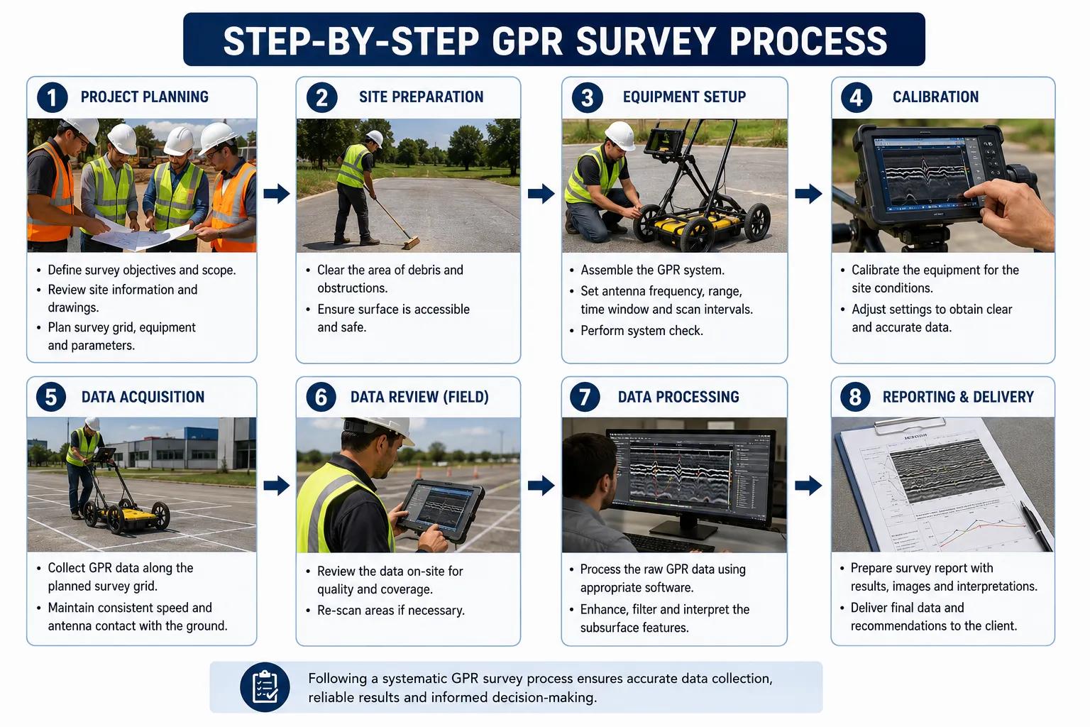
Step-by-Step GPR Survey Process
At Bhoojal Survey, our professional GPR survey services follow a rigorous, systematic process to ensure maximum accuracy and project-ready reporting:
Step 1: Site Inspection & Briefing: Understanding project scope, existing utility records, and site access conditions.
Step 2: Survey Planning: Defining scan grid patterns, antenna frequency selection, and depth targets.
Step 3: Radar Equipment Setup: Calibrating GPR antennas and connecting to data logging systems.
Step 4: Field Scanning: Systematically traversing the survey grid with the GPR unit to collect subsurface data.
Step 5: Underground Signal Collection: Recording reflected wave data across all survey lines.
Step 6: Data Processing & Analysis: Running collected data through specialized GPR processing software.
Step 7: Utility Mapping & Interpretation: Identifying and mapping detected utilities and anomalies.
Step 8: Technical Report Preparation: Delivering a comprehensive report with annotated maps, depth profiles, and utility layouts.
Factors Affecting GPR Survey Accuracy
While GPR survey technology is one of the most reliable underground investigation methods available, several factors influence the quality and depth of results:
- Soil Conditions: Clay-rich, waterlogged, or highly conductive soils can attenuate GPR signals, reducing penetration depth.
- Moisture Content: High soil moisture increases electrical conductivity and limits radar penetration.
- Material Conductivity: Metallic objects reflect strongly; plastic or concrete utilities require careful antenna frequency selection.
- Depth Limitations: GPR is highly effective up to 5–6 metres in most soils; deeper investigation may need complementary geophysical methods.
- Surface Conditions: Rough, broken, or obstructed surfaces may affect antenna coupling and scan quality.
- Data Interpretation Quality: Expert interpretation by experienced geophysical professionals is critical to accurate utility identification.
Benefits of Professional GPR Survey Services
Investing in a professional non-destructive underground investigation delivers measurable value across every phase of an infrastructure project:
- Accurate Underground Mapping: Precise identification of pipe, cable, and utility locations beforeexcavation.
- Reduced Excavation Risk: Eliminates accidental damage to live utilities, reducing site accidentsand costly repairs.
- Faster Project Execution: Reliable subsurface data accelerates planning and constructiontimelines.
- Non-Destructive Investigation: Zero ground disturbance during the survey process.
- Improved Infrastructure Planning: Detailed utility maps support better design decisions andclash avoidance.
- Regulatory Compliance: Demonstrates due diligence in utility identification as required by safetystandards.
- Cost Savings: Early detection of underground hazards prevents expensive emergencyinterventions.
- Data-Driven Decision Making: Professional GPR reports provide actionable intelligence forproject engineers.
How Bhoojal Survey Can Help Your Project
Bhoojal Survey is a trusted, experienced geophysical and underground utility investigation consultancy serving infrastructure projects across India. Here is exactly how we add value to your project:
- End-to-End GPR Survey Services:
From initial site assessment to final utility map delivery — our teams manage the entire GPR survey process, saving your project team time and coordination effort.
- Underground Utility Detection Before Excavation:
We detect and map buried water mains, gas lines, electrical cables, telecom ducts, and sewer pipes — giving your construction team a clear picture of what is underground before a single metre of ground is opened.
- Hydrogeological & Borewell Investigation Support:
Using SSRMPATS, GER DETECT, and PQWT instruments, our team helps identify the best borewell and open well locations, supporting groundwater projects for industries, municipalities, and agricultural stakeholders.
- Concrete Scanning & Structural Investigation:
We scan concrete slabs, beams, and retaining walls to detect embedded rebar, post-tension cables, voids, and potential structural weaknesses — critical for renovation and retrofitting projects.
- Technical Reports for Regulatory & Design Use:
Our detailed GPR survey reports are prepared by qualified geophysical professionals and are suitable for submission to regulatory bodies, client organizations, and EPC contractors.
- Pan-India Project Coverage:
Bhoojal Survey mobilizes field teams to sites across India — covering smart city zones, industrial parks, railway corridors, highway projects, and airport infrastructure sites in states including Madhya Pradesh, Maharashtra, Rajasthan, Gujarat, Uttar Pradesh, and beyond.
- Customized Investigation Solutions:
Every project has unique ground conditions and utility complexity. We design customized GPR survey plans — selecting the right antenna frequencies, scan densities, and supplementary geophysical methods — to deliver results matched to your project's needs.
- Quick Mobilization & Reliable Reporting:
We understand that infrastructure projects run on tight schedules. Bhoojal Survey offers rapid field mobilization and delivers professional survey reports within agreed timelines to keep your project on track.
Why Choose Bhoojal Survey for GPR and Geophysical Services?
When you need professional Ground Penetrating Radar survey services in India, Bhoojal Survey delivers the combination of technical expertise, advanced equipment, and professional reporting that modern infrastructure projects demand.
- Experienced geophysical survey professionals with hands-on field expertise
- Advanced GPR survey instruments calibrated for Indian soil and site conditions
- Comprehensive underground utility mapping and hydrogeological investigation capabilities
- Accurate, court-admissible technical reports prepared by qualified experts
- Seamless coordination with EPC contractors, government agencies, and project consultants
- Pan-India survey services with rapid mobilization capacity
- Transparent project pricing and milestone-based delivery
- Post-survey technical support and data interpretation assistance
Conclusion
Understanding the GPR survey full form — Ground Penetrating Radar — is just the first step. The real value lies in deploying this technology correctly, with the right instruments, experienced professionals, and a structured survey methodology that delivers actionable underground utility data to your project team.
Whether your project is a smart city utility corridor, a metro rail extension, an industrial site expansion, or a government infrastructure development, Bhoojal Survey provides the underground utility mapping, pipeline detection survey, and geophysical radar survey services you need to keep your project safe, compliant, and on schedule.
Do not leave underground safety to guesswork. Partner with Bhoojal Survey — India's trusted geophysical and underground utility investigation consultancy — and build with confidence.
Frequently Asked Questions (FAQ)
Q: What is the full form of GPR survey?
A: GPR stands for Ground Penetrating Radar. A GPR survey is a non-destructive geophysical investigation method that uses electromagnetic radar waves to detect and map underground utilities, structures, and anomalies without excavation.
Q: How does Ground Penetrating Radar work?
A: GPR works by transmitting high-frequency electromagnetic pulses into the ground. When these waves hit a buried object or material boundary, they reflect back to the surface antenna. The system records the travel time of these reflected signals and converts them into a subsurface image, which trained experts interpret to identify underground features.
Q: What is GPR survey used for?
A: GPR survey is used for underground utility detection, concrete scanning, road and pavement assessment, archaeological investigation, geological mapping, borewell site investigation, tunnel and metro rail projects, and airport runway inspection, among many other applications.
Q: Is GPR survey accurate for underground utility detection?
A: Yes. Professional GPR survey services delivered by experienced geophysical experts with correctly calibrated equipment provide very high accuracy for underground utility detection. Accuracy is influenced by soil type, moisture, depth, and interpretation expertise.
Q: What industries use GPR surveys in India?
A: GPR surveys are used across construction, infrastructure development, EPC contracting, mining, railways, highways, airports, smart city projects, industrial plants, and government utility agencies across India.
Q: How deep can GPR detect underground utilities?
A: Depending on soil conditions and antenna frequency, GPR can reliably detect utilities at depths of 0.5 to 5–6 metres in typical Indian soil conditions. In low-conductivity sandy or rocky soils, penetration depths can be greater.
Q: Is GPR survey a non-destructive investigation method?
A: Yes. Ground Penetrating Radar survey is entirely non-destructive — no excavation, boring, or ground disturbance is required during the survey process. It is safe for use over live utility areas and in sensitive environments.
Q: Why should I choose Bhoojal Survey for GPR services?
A: Bhoojal Survey offers experienced geophysical survey teams, advanced GPR and hydrogeological instruments (including SSRMPATS, GER DETECT, and PQWT), and professional technical reporting for underground utility mapping, borewell investigation, and infrastructure survey projects across India.