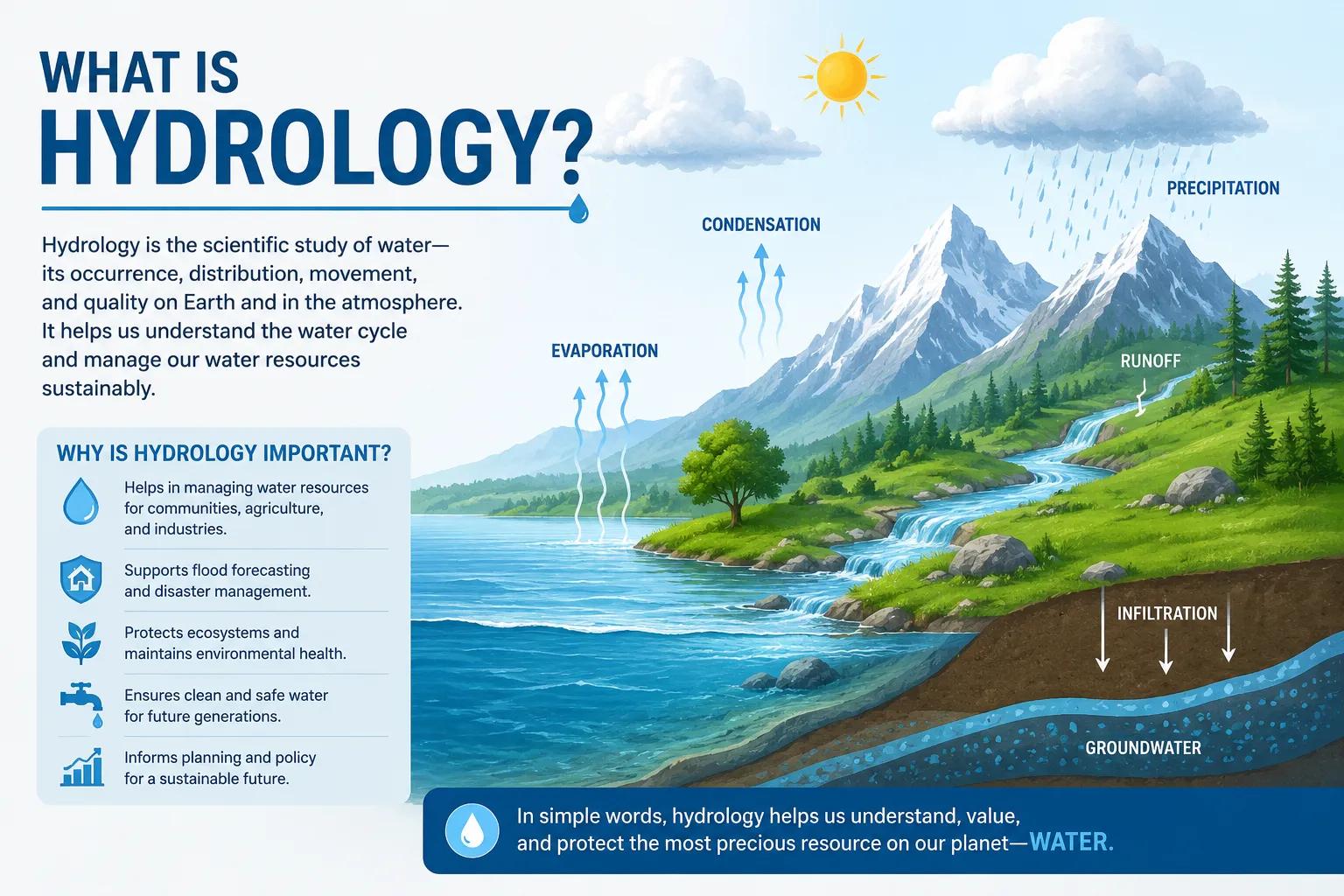
What is Hydrology?
Water is the lifeblood of India’s developing infrastructure, expanding agriculture, and rapid urban growth. But how do we track, measure, and sustainably manage this vital resource? It all starts with a foundational scientific discipline.
What is hydrology? Hydrology is the scientific study of the movement, distribution, and quality of water on Earth, including the hydrological cycle, water resources, and watershed sustainability. It bridges the gap between environmental science and civil engineering, determining how water interacts with the atmosphere, surface terrain, and underlying geological structures.
For infrastructure developers, government bodies, and agricultural planners across India, understanding what is hydrology is the first step toward resilient project design, flood mitigation, and long-term water security.
What is Hydrology and Why is it Important?
At its core, what is hydrology can be defined as the study of how water moves across the globe. The scope of hydrological science encompasses everything from tracking a single raindrop to managing massive river basin systems.
This science is crucial because water is neither static nor infinite. By analyzing precipitation patterns, soil moisture, and streamflow, hydrologists map out exactly how much water is available in a specific region. For a fast-growing nation like India, this data prevents catastrophic planning failures. It ensures that cities have dependable drinking water, factories operate without disrupting local communities, and agricultural zones remain productive during changing weather cycles.
Key Components of Hydrology
To understand how water behaves, a professional hydrological survey focuses on the core stages of the water cycle:
- Precipitation: Rain and snow that deliver fresh water to the earth's surface.
- Evaporation & Transpiration: The return of water vapor back into the atmosphere from land, open water, and plants.
- Infiltration: The process by which surface water sinks into the upper layers of soil.
- Runoff: Excess rainwater that flows over land surfaces, feeding into streams, rivers, and lakes.
- Groundwater Recharge: The critical movement of water downward through soil layers to replenish deep aquifers.
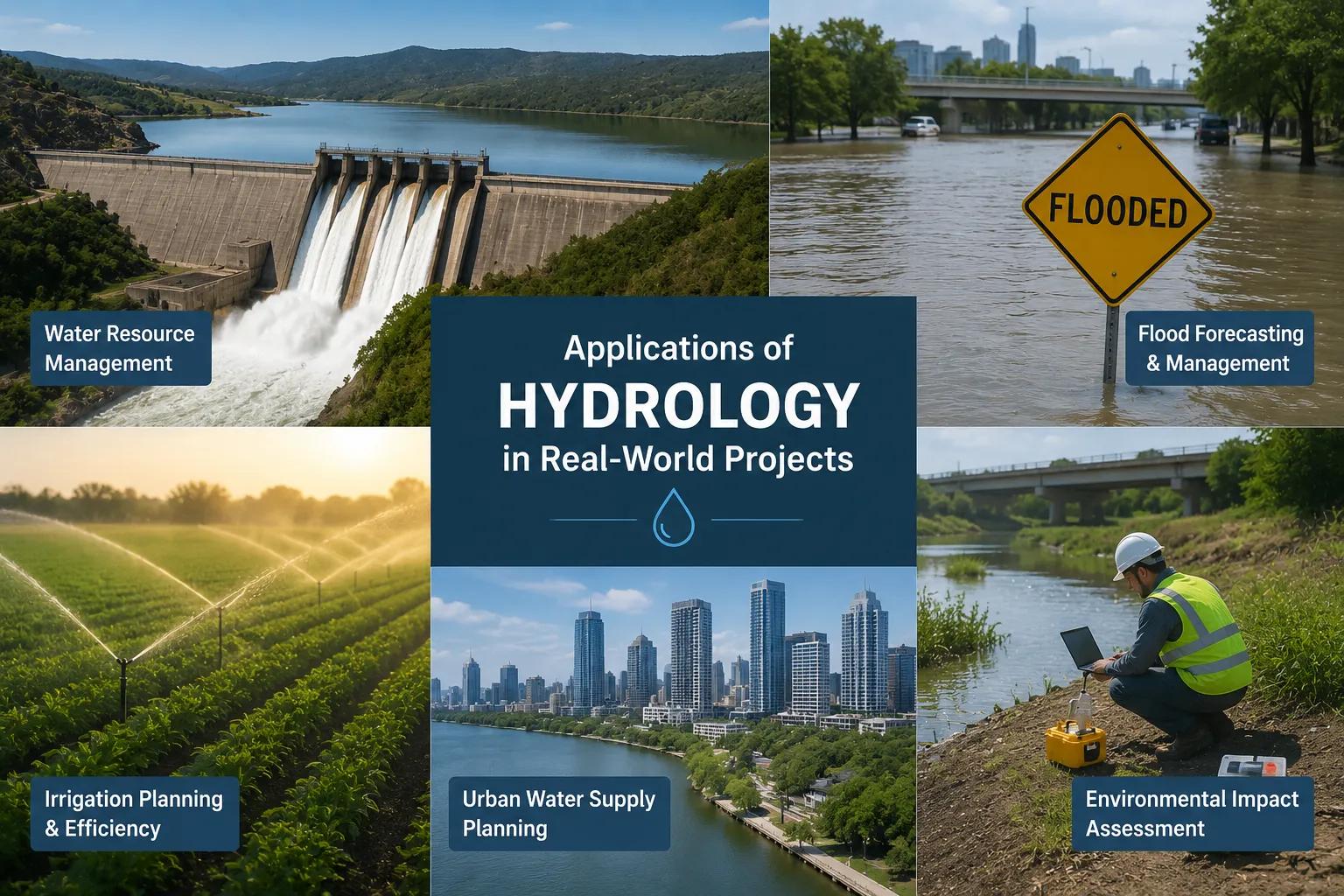
Applications of Hydrology in Real-World Projects
Hydrological science is not just theoretical; it drives real-world engineering and environmental planning. Modern infrastructure relies on data-driven scientific water resource investigation and analysis to stay safe and sustainable.
Flood and Watershed Management
Engineers use advanced rainfall runoff analysis and hydrological modelling to predict peak river flows. This data is essential for designing dams, drainage networks, and flood management projects that protect lives and property.
Smart Infrastructure and Irrigation Planning
Before constructing highways, bridges, or smart cities, developers conduct a comprehensive hydrological assessment to ensure structural designs do not disrupt natural drainage lines or cause severe waterlogging.
Advanced Aquifer Mapping
Managing groundwater requires highly specialized on-site field work. Bhoojal Survey delivers advanced hydrological and geophysical survey solutions, conducting hydrogeological survey using SSRMPATS Instrument, GER DETECT, and PQWT at site for open well / borewell location. This pinpoint accuracy saves time and ensures sustainable yield for agricultural and industrial setups.
Importance of Hydrology in Water Resource Management
As climate volatility impacts seasonal monsoons, structured water resource planning has become a national priority.
[Hydrological Investigation] │ ▼ [Accurate Resource Mapping] ──► [Flood & Drought Mitigation] │ ▼ [Sustainable Groundwater Conservation]
A scientific water cycle study allows environmental water management consultancy experts to balance human consumption with ecological conservation. By understanding localized groundwater recharge rates, regional authorities can prevent over-extraction, promote rainwater harvesting, and execute successful watershed development projects that protect the environment for future generations.
Why Choose Bhoojal Survey?
Bhoojal Survey is a premier hydrological investigation company in India, delivering precision-driven scientific hydrology solutions for complex engineering and environmental challenges.
- Expert Team: Our seasoned hydrologists specialize in river basin analysis and surface water hydrology.
- Cutting-Edge Technology: We leverage advanced geophysical instruments and digital modeling tools for high-accuracy resource mapping.
- Regulatory Compliance: We provide comprehensive reports tailored for environmental impact studies and government clearances.
- Pan-India Capability: From localized watershed analysis services to mega infrastructure planning, we serve clients nationwide.
Conclusion
Understanding what is hydrology is fundamental to securing India’s economic and environmental future. From safeguarding cities against extreme weather to ensuring a steady supply of clean groundwater, scientific hydrological investigations turn unpredictable natural forces into manageable, sustainable assets.
Ready to secure your project's water future? Contact Bhoojal Survey today for professional water resource assessment services and tailored engineering advice.
Frequently Asked Questions
1. What is hydrology in simple terms?
Hydrology is the science that studies how water moves, circulates, and distributes across the earth's surface, underground, and in the atmosphere.
2. Why is a professional hydrological survey necessary for construction projects in India?
A survey identifies local flood risks, determines natural drainage pathways, and assesses surface water behavior to prevent future structural damage and ensure regulatory compliance.
3. How does hydrology help in groundwater assessment programs?
Through groundwater hydrology and geophysical testing, experts map underground aquifers, estimate recharge rates, and locate sustainable spots for wells and borewells.
4. What is the difference between hydrology and hydrogeology?
Hydrology generally focuses on surface water movement and the overall water cycle, while hydrogeology specifically examines how groundwater interacts with subsurface soil and geological rock formations.
5. Which industries require professional hydrological consultancy services?
Real estate developers, infrastructure firms, mining operations, agricultural planners, and government bodies managing irrigation or disaster mitigation all rely heavily on these services.