What is Hydrological Disaster and Why It Matters for India
India faces some of the world's most severe water-related natural disasters every year. From catastrophic river floods in Assam to devastating droughts in Marathwada, hydrological disasters directly impact millions of lives, agricultural systems, and critical infrastructure. Understanding what a hydrological disaster is — and how to manage it scientifically — is no longer optional. It is essential for governments, planners, engineers, and environmental consultants working across India.
At Bhoojal Survey, we provide advanced hydrological investigation, flood risk assessment, and watershed analysis services to help organisations prepare for, respond to, and recover from hydrological disasters effectively.
What is a Hydrological Disaster?
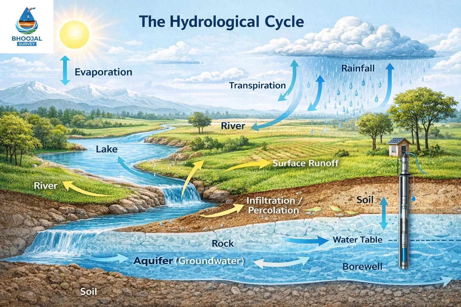
A hydrological disaster is a natural disaster caused by extreme changes in the water cycle that result in significant damage to life, property, and the environment. It occurs when the normal distribution, movement, or availability of water — through rivers, groundwater, rainfall, and surface runoff — becomes dangerously imbalanced.
Common types of hydrological disasters include:
- Floods — caused by excessive rainfall, river overflow, or poor drainage
- Droughts — prolonged water scarcity affecting agriculture and water supply
- Flash floods — sudden, intense floods from heavy localised rainfall
- Landslides triggered by water — slope failures caused by soil saturation
- Waterlogging — prolonged inundation of agricultural and urban land
Hydrological disaster management depends on accurate monitoring, early warning systems, and scientific analysis of water systems at the watershed and river basin level.
What Causes Hydrological Disasters?
Understanding the causes is the first step in hydrological risk assessment and disaster risk reduction. Key causes include:
- Heavy rainfall and extreme weather events intensified by climate change and hydrological disaster patterns
- Deforestation reducing natural water absorption and increasing runoff
- Urbanisation replacing permeable land with concrete, worsening stormwater disaster analysis scenarios
- River blockages from sedimentation, encroachments, and poor land use
- Poor watershed management failing to regulate water flow across catchment areas
- Climate change accelerating glacial melting, erratic monsoons, and prolonged drought conditions across India
Scientific hydrological analysis helps identify vulnerable zones before disasters strike, supporting effective environmental disaster management planning.
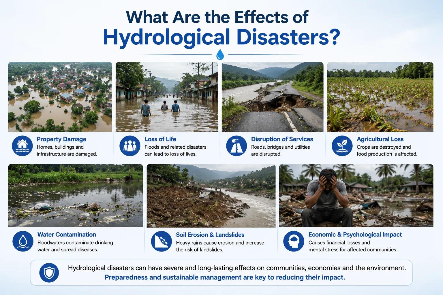
What Are the Effects of Hydrological Disasters?
The effects of a hydrological disaster are wide-ranging and often long-lasting:
- Flood damage to roads, bridges, buildings, and irrigation infrastructure
- Water scarcity during droughts destroying crops and drinking water supplies
- Agricultural losses threatening food security and rural livelihoods
- Environmental degradation including soil erosion, river sedimentation, and ecosystem damage
- Human displacement and loss of life, particularly in flood-prone river basins
- Economic losses running into thousands of crores annually across Indian states
To assess these impacts accurately, Bhoojal Survey conducts hydrogeological surveys using advanced instruments including SSRMPATS, GER DETECT, and PQWT at site for open well and borewell location identification. Our team provides advanced hydrological and geophysical survey solutions combined with scientific environmental investigation and analysis to deliver reliable disaster impact assessments.
How Are Hydrological Disasters Assessed and Managed?
Professional hydrological disaster assessment uses a structured, technology-driven approach:
- Hydrological investigation to study catchment characteristics, rainfall patterns, and runoff behaviour
- GIS and satellite-based flood hazard mapping to identify high-risk zones with precision
- Watershed disaster analysis to evaluate how land use changes affect water flow
- Flood modelling techniques simulating river flood disaster scenarios under various rainfall conditions
- Hydrological emergency planning and disaster risk reduction frameworks aligned with NDMA guidelines
- Water resource disaster management strategies for sustainable groundwater and surface water use
These methods together form a complete hydrological risk assessment system, enabling decision-makers to plan infrastructure, manage river basins, and reduce vulnerability proactively.
Why Choose Bhoojal Survey for Hydrological Disaster Consultancy?
Bhoojal Survey is a trusted name in professional hydrology consultancy services across India. Here is why clients choose us:
- Experienced hydrology experts with deep field knowledge across diverse Indian river basins and watersheds
- Advanced flood and watershed analysis technologies for accurate, data-driven assessments
- Comprehensive hydrological investigation services in India covering flood modelling, drought analysis, and environmental risk assessment
- Professional reporting aligned with NDMA, CWC, and Ministry of Jal Shakti standards
- Pan-India survey services covering urban, rural, and remote locations
- Customised environmental disaster management solutions tailored to each project's unique hydrological context
Whether you are planning a new infrastructure project, assessing flood vulnerability, or developing a watershed management strategy, Bhoojal Survey delivers the scientific precision and professional expertise your project demands.
Conclusion
Hydrological disasters are among the most destructive natural events affecting India's environment, economy, and communities. Addressing them requires more than awareness — it demands scientific hydrological analysis, accurate flood hazard mapping, and professional consultancy support at every stage of planning and response.
Bhoojal Survey combines field expertise, advanced survey instruments, and environmental investigation capabilities to provide comprehensive hydrological disaster management solutions across India. If your project requires reliable flood risk assessment, watershed analysis, or hydrological investigation services, contact Bhoojal Survey today and let our experts guide your environmental planning with confidence.
Frequently Asked Questions (FAQs)
1. What is a hydrological disaster? A hydrological disaster is a natural disaster caused by extreme imbalances in the water cycle — such as floods, droughts, or flash floods — that cause severe damage to life, property, agriculture, and the environment.
2. What are the main causes of hydrological disasters in India? The main causes include heavy monsoon rainfall, deforestation, rapid urbanisation, poor watershed management, river encroachments, and the increasing impact of climate change on India's water systems.
3. How are floods related to hydrological disasters? Floods are one of the most common types of hydrological disasters. They occur when rivers overflow their banks or drainage systems fail to handle extreme rainfall, causing widespread damage to infrastructure and communities.
4. What are the effects of hydrological disasters on the environment? Hydrological disasters cause soil erosion, river sedimentation, groundwater depletion, ecosystem damage, agricultural losses, and long-term degradation of India's natural water resources.
5. How can hydrological disasters be managed professionally? Hydrological disasters can be managed through scientific hydrological investigation, GIS-based flood hazard mapping, watershed analysis, flood modelling, early warning systems, and professional environmental disaster management consultancy aligned with NDMA guidelines.