Water does not wait for permissions. It follows terrain, fills low points, and overwhelms whatever drainage was not designed to handle it. For infrastructure projects across India — solar parks, industrial corridors, airports, highways — the question is never whether flooding is possible. The question is whether your project is ready for it.
Professional Hydraulic modelling answers that question before construction begins, not after the first monsoon causes damage worth crores.
Protecting High-Value Infrastructure from Hydrological Risks
The Financial Impact of Poor Drainage Planning
Drainage failures are rarely dramatic in isolation — they are a series of compounding problems. A waterlogged access road delays equipment movement. A flooded cable trench shorts the electrical system. A submerged transformer requires full replacement.
On project sites where flood drainage design was skipped or done superficially, post-flood repair costs have consistently exceeded the budget that a proper hydrology study would have required. The math is simple, and the lesson is expensive.
Poor drainage design also creates legal and contractual exposure. When project timelines slip due to monsoon flooding, EPC contractors face liquidated damages. Insurers look for documentation of flood risk assessment. Without it, claims get complicated.
Identifying Vulnerabilities in Solar Farms and Industrial Hubs
Solar parks are typically developed on flat, low-lying agricultural land — terrain that drains slowly and accumulates water quickly during heavy rainfall. Inverter stations, transformer yards, and underground cable networks are all at risk when waterlogging is not anticipated.
Industrial hubs replace permeable land with rooftops, concrete yards, and paved surfaces. This dramatically increases peak runoff and reduces natural infiltration. Without hydraulic modelling, no one knows exactly how much additional water the site will generate — or where it will go.
Equipment damage, production shutdowns, and safety incidents during flood events are all preventable with site-specific flood risk assessment carried out before the project breaks ground.
Why Standard Surveys Fail to Capture Dynamic Flood Risks
A conventional topographic survey shows you the shape of the land at one point in time. It cannot show you what happens when 200mm of rainfall hits that land in six hours during a 50-year storm event.
Floods are dynamic. Water moves across terrain, follows channels, backs up at constrictions, and overtops embankments in ways that only hydraulic modelling can simulate. Static elevation data, without hydrological analysis, gives a false sense of security.
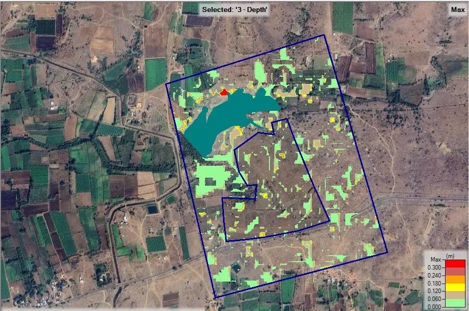
HEC-RAS modelling and 2D unsteady flow simulation transform terrain data into a time-sequenced picture of how water behaves — showing depth, velocity, and extent of inundation under multiple storm scenarios.
Comprehensive Hydrology and Flood Modelling Solutions
Area Flood Drainage Studies for EPC Contractors
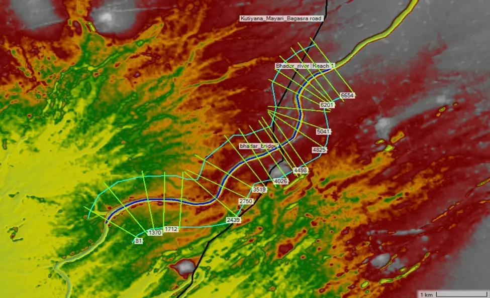
An Area Flood Drainage Study (AFDS) forms the technical backbone of flood-safe project design. It covers watershed delineation, design storm estimation, runoff calculation, inundation mapping, and Highest Flood Level (HFL) determination.
For EPC contractors, AFDS outputs directly drive civil design decisions — platform heights, bund elevations, drain sections, and culvert sizing. These are not advisory outputs. They are engineering inputs that determine whether a project survives its first monsoon season.
HEC-RAS 2D Unsteady Flow Analysis for Precision Mapping
HEC-RAS modelling is the globally accepted standard for flood simulation in engineering applications. Using 2D unsteady flow analysis, it generates flood depth maps, velocity vector fields, and inundation boundaries for any design return period.
This level of detail from Flood modelling allows engineers to identify exactly which areas of a site require elevated platforms, where bunds must be placed, and how drainage outfalls must be designed to function under peak flow conditions. Generic contour surveys cannot provide this information.
Post-Development Runoff Management
Land use change has a direct and measurable impact on hydrology. Converting agricultural land to solar farm or industrial use reduces infiltration, increases impervious area, and raises peak discharge from the same catchment.
Post-development hydraulic modelling quantifies this change and provides the basis for designing detention ponds, diversion channels, and outfall structures that absorb the increased runoff without creating downstream flooding problems.
Core Hydraulic Modelling Services
Bhoojal Survey provides a full range of site-specific hydraulic modelling services for infrastructure developers, EPC contractors, and project owners.
Solar Plant AFDS delivers a complete Area Flood Drainage Study for solar parks, including inundation maps, HFL determination, platform height recommendations, and drainage network design.
Airport Hydrology covers runway ponding analysis, stormwater conveyance design, and drainage layouts prepared in compliance with DGCA and AAI technical standards.
Post-Development Hydraulics analyses the change in runoff patterns following land-use change and provides detention pond design and outlet sizing to manage increased peak flows.
Flood Modelling Integration provides flow, depth, and velocity mapping for asset safety planning, enabling engineers to determine correct NGL for all critical equipment and infrastructure.
Technical Modelling Workflow and Tools
Every hydraulic modelling study at Bhoojal Survey follows a rigorous, data-driven workflow using industry-standard tools.
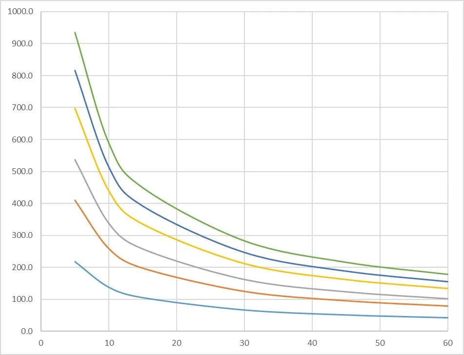
HEC-RAS 2D handles flood routing and unsteady flow simulation, producing spatially detailed inundation outputs. SWAT is used for watershed-scale hydrological simulation and long-term runoff analysis. DEM and drone-captured DTM provide high-resolution terrain inputs essential for accurate flood modelling. IMD rainfall records covering 40 years of historical data underpin all design storm calculations. Gumbel and Log-Pearson Type III frequency analysis methods are applied to derive design rainfall for 25, 50, and 100-year return periods.
Key Benefits of Flood Modelling for Your Project
Asset Protection: Correct NGL determination protects transformers, inverters, cable networks, and structural foundations from flood inundation.
Risk Mitigation: Scenario-based flood modelling across 25, 50, and 100-year return periods gives project owners a complete picture of long-term hydrological risk.
Cost Optimisation: Accurate drain sizing prevents both over-engineering and dangerous under-design — both of which cost money at different stages of the project lifecycle.
Bankable Compliance: Financial institutions and insurers increasingly require documented flood risk assessment. Bhoojal Survey reports are prepared to meet these standards.
Detailed Deliverables
Every hydraulic modelling engagement delivers inundation maps showing flood extent for multiple return periods, depth and velocity maps for safety-critical zone identification, AutoCAD DWG drainage layouts ready for direct use by the civil engineering team, and complete drainage design outputs including channel cross-sections, culvert designs, and detention pond specifications.
The Bhoojal Survey Advantage
Bhoojal Survey brings together advanced computational tools, verified data sources, and deep project experience to deliver hydraulic modelling that is genuinely useful — not just compliant.
Our work is built on HEC-RAS, SWAT, and full GIS integration. Rainfall analysis is always IMD-based, using 40 years of validated historical records. Terrain data combines ground survey and satellite-derived inputs for maximum accuracy. Every model is built from scratch for the specific site — no templates, no recycled outputs.
We have delivered hydraulic modelling and drainage design solutions for solar parks, industrial hubs, airports, and linear infrastructure projects across multiple Indian states. Our deliverables are engineering-ready, fast to produce, and designed to support bankable project documentation.
When a project owner or EPC contractor needs flood risk assessment that stands up to technical scrutiny, Bhoojal Survey provides exactly that.
Educational Hydraulic Models: The Foundation of Real Engineering
The principles behind professional hydraulic modelling are the same ones demonstrated in educational settings every day. A hydraulic lift model shows how fluid under pressure transmits force — the same principle governs flow in pressurised drainage pipes. A hydraulic lift working model demonstrates Pascal's Law in action, which underpins all pressure-based flow calculations.
A hydraulic bridge model illustrates how water interacts with structural elements — directly relevant to bridge hydraulics and culvert design in flood studies. A hydraulic arm model demonstrates controlled force transmission through fluid, mirroring how we analyse flow energy in channel systems. Students working through a hydraulics model answer paper are learning the governing equations that power HEC-RAS simulations at the professional level.
The gap between classroom model and real-world flood modelling is one of scale, data, and computational power — not of underlying principle.
Problems Without Hydraulic Modelling
Flooding of equipment yards, cable trenches, and access infrastructure during monsoon events. Drainage failure causing structural damage, operational downtime, and safety risk. Cost overruns from unplanned civil remediation after site flooding. Compliance risk when lenders, insurers, or regulators require flood documentation that does not exist.
Benefits of Professional Hydraulic Modelling
Accurate flood prediction across all relevant storm return periods. Optimised drainage design that is right-sized from day one. Cost savings through elimination of post-construction remedial works. Better planning at site selection, detailed design, and operational stages.
Conclusion: Protect Your Project Before the Monsoon Does
Every infrastructure project in India faces some level of hydrological risk. The ones that manage that risk proactively — through proper hydraulic modelling, flood risk assessment, and drainage design — avoid the shutdowns, the equipment losses, and the compliance problems that others face.
Bhoojal Survey provides the technical expertise, the right tools, and the site-specific approach that serious projects require. Whether you are developing a solar farm, planning an industrial facility, or managing airport drainage compliance, the time to act is before construction starts.
Contact Bhoojal Survey today for a consultation. Get engineering-grade hydraulic modelling that protects your investment for the full operational life of your project.
Frequently Asked Questions
Q1: What is the difference between hydraulic modelling and a standard topographic survey? A topographic survey captures terrain elevation at a point in time. Hydraulic modelling uses that terrain data alongside rainfall records, soil parameters, and hydrological analysis to simulate how water actually moves across a site during storm events — providing flood depth, velocity, and inundation extent that a survey alone cannot deliver.
Q2: Which projects require a flood risk assessment and AFDS? Any infrastructure project on or near a flood-prone catchment — including solar parks, industrial developments, airports, and highway corridors — benefits from a formal flood risk assessment. Lenders, insurers, and regulatory bodies such as DGCA increasingly require documented flood modelling as part of project approvals.
Q3: How accurate is HEC-RAS modelling for Indian project conditions? HEC-RAS modelling accuracy depends on the quality of terrain data and rainfall inputs. Bhoojal Survey uses drone-derived DTM for high-resolution terrain and 40-year IMD rainfall records for statistically robust design storm estimation — delivering flood modelling outputs that reflect actual site conditions, not approximations.