What is a Flood Modeller?
A flood modeller is a trained hydrological expert who designs and runs computational models to understand how floodwaters spread, accumulate, and recede across landscapes. Using hydraulic flood modeller tools and GIS platforms, these professionals simulate rainfall-runoff processes, river overflow scenarios, and stormwater flood analysis under varying climatic conditions.
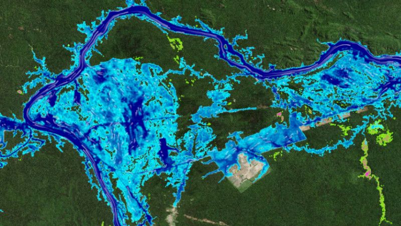
Their work integrates flood prediction systems, floodplain analysis, and terrain modelling to produce flood inundation mapping and flood hazard mapping outputs that directly inform risk mitigation strategies. In India, where monsoon variability and encroachment on natural floodplains create serious challenges, the role of a professional flood modeller is more critical than ever.
Why Flood Modelling is Important
Effective flood modelling supports informed decision-making at every stage of infrastructure and environmental planning. Key benefits include:
- Flood risk reduction — Early identification of high-risk zones minimises human and economic losses.
- Infrastructure protection — Highways, bridges, and urban drainage systems are designed with accurate flood simulation analysis data.
- Urban flood planning — Smart city developers use flood forecasting techniques to future-proof drainage networks.
- Watershed flood analysis — River basin flood assessment guides sustainable land use and reservoir management.
- Disaster preparedness — Government disaster management agencies rely on flood modelling for emergency response planning.
- Environmental flood investigation — EIA projects require detailed floodplain and environmental assessment data.
Methods Used by a Flood Modeller
Modern flood modelling draws on a broad toolkit of geospatial, hydrological, and field-based techniques. At Bhoojal Survey, our flood modeller experts apply:
- GIS Flood Mapping — Spatial analysis of terrain, land cover, and drainage networks to delineate flood-prone areas.
- Hydrological Watershed Analysis — Rainfall-runoff modelling across catchments using HEC-HMS and SWAT frameworks.
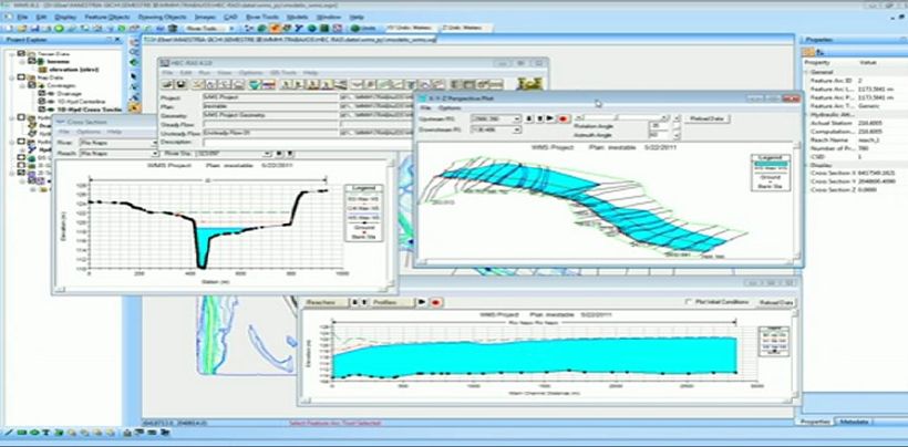
- Hydraulic Simulation Modelling — 1D and 2D hydraulic flood modeller simulations using HEC-RAS and MIKE FLOOD.
- Floodplain and Terrain Analysis — LiDAR-based DEM processing for accurate flood inundation mapping.
- Flood Forecasting Systems — Real-time flood prediction system integration with weather data for early warning.
- Field Hydrogeological Surveys — Conducting hydrogeological survey using SSRMPATS Instrument, GER DETECT, and PQWT at site for open well / borewell location to validate subsurface hydrological conditions.
Our advanced hydrological and geospatial survey solutions combine remote sensing, ground-truthing, and scientific flood investigation and analysis to deliver reliable flood risk insights across diverse Indian terrain — from river deltas to urban watersheds.
Why Choose Bhoojal Survey for Flood Modelling Services?
Bhoojal Survey is a trusted name in hydrological investigation and flood risk assessment across India. Our team of experienced hydrological flood modeller professionals combines deep technical expertise with state-of-the-art GIS and simulation tools to deliver accurate, compliant, and actionable flood modelling solutions.
✔ Experienced hydrological experts with pan-India project coverage
✔ Professional reporting compliant with NDMA,
CWC, and MoEFCC norms
✔ Advanced GIS flood modelling and hydraulic simulation platforms
✔ Customised environmental flood investigation and consultancy
✔ Accurate flood risk assessment with scientific rigour
✔ End-to-end flood mitigation solutions for government and private sector
Conclusion
Professional flood modeller services are no longer optional — they are a fundamental requirement for safe, sustainable, and climate-resilient development in India. Whether you are planning a smart city drainage network, assessing flood risk for a highway corridor, or preparing a mandatory EIA report, accurate flood modelling ensures your project meets both safety standards and regulatory requirements.
Bhoojal Survey brings proven expertise in flood simulation analysis, GIS flood hazard mapping, watershed flood mitigation, and hydrological investigation — backed by advanced field survey technology and a commitment to scientific accuracy. Partner with us for reliable flood risk management solutions that protect lives, infrastructure, and the environment.
■ Contact Bhoojal Survey Today for Professional Flood Modeller Consultancy Services Across India
Frequently Asked Questions (FAQs)
Q1. What does a flood modeller do?
A flood modeller simulates how floodwaters behave across catchments and urban areas using hydrological and hydraulic software. They produce flood inundation maps, flood hazard assessments, and flood forecasting outputs that help engineers, planners, and government bodies make informed flood risk management decisions.
Q2. Why is flood modelling important for infrastructure projects in India?
India's rapidly expanding infrastructure — roads, bridges, smart cities, and urban drainage systems — faces significant flood risk due to monsoon variability and changing land use. Professional flood modelling ensures designs account for peak flood scenarios, protecting both investment and public safety while meeting NDMA and CWC compliance requirements.
Q3. How does GIS improve flood modelling accuracy?
GIS flood modelling integrates satellite imagery, LiDAR terrain data, drainage networks, and land-use maps into a single spatial framework. This allows a flood modeller to precisely delineate floodplains, model water flow paths, and generate detailed flood hazard maps with far greater accuracy than traditional methods.
Q4. Which industries require professional flood modelling services?
Flood modelling is essential across infrastructure development, urban planning, smart city projects, highway and bridge engineering, environmental consultancy, government disaster management agencies, watershed management authorities, riverfront development, and construction companies working near flood-prone river basins across India.
Q5. How accurate are flood simulation models?
Modern flood simulation models — when built on quality hydrological data,calibrated against observed flood events, and validated using ground-truth surveys — deliver high accuracy for design flood estimation and risk mapping. Bhoojal Survey combines field-based hydrogeological investigation with advanced GIS and hydraulic tools to ensure our flood models meet professional and regulatory standards.