Flood Indicator Model
Floods are among the most destructive natural disasters in India — affecting millions of lives, damaging infrastructure, and disrupting agriculture every monsoon season. Predicting where, when, and how severely floods will strike requires more than weather forecasts. It demands a scientifically structured flood indicator model — a tool that transforms raw hydrological data into actionable flood risk intelligence.
At Bhoojal Survey, we provide professional flood modelling, GIS flood mapping, and hydrological investigation services across India, helping government agencies, infrastructure developers, and urban planners make informed decisions before disaster strikes.
What is a Flood Indicator Model?
A flood indicator model is a scientific framework used to identify, measure, and predict flood risk based on hydrological, topographic, and meteorological parameters. It combines multiple flood risk indicators — including rainfall intensity, river discharge levels, soil saturation, and land use patterns — to generate a comprehensive picture of flood vulnerability across a given area.
In practical terms, a flood indicator model helps hydrologists and disaster management professionals determine which areas are most susceptible to flooding, how quickly floodwaters may rise, and what the likely damage footprint could be. It is a core component of modern flood hazard assessment and environmental flood monitoring systems used globally and increasingly across India's river basins and urban centres.
Why Flood Indicator Models Are Important
The value of a flood indicator model goes far beyond academic analysis. In India's complex hydrological landscape — shaped by monsoon variability, rapid urbanisation, and climate change — these models serve critical functions:
- Early Warning Systems — Flood forecasting indicators allow authorities to issue timely alerts, reducing loss of life and enabling emergency preparedness.
- Infrastructure Protection — Bridges, highways, urban drainage systems, and industrial zones can be designed with accurate floodplain analysis data.
- Watershed and Environmental Management — Models help identify vulnerable catchment areas and guide watershed flood mitigation planning.
- Disaster Preparedness Planning — Government bodies use flood disaster prediction outputs to allocate resources and build resilient response plans.
- Investment Security — Real estate developers, smart city planners, and construction companies use flood vulnerability analysis to de-risk long-term projects.
Without reliable flood indicator model data, infrastructure decisions become guesswork — with costly and sometimes deadly consequences.
Methods Used in Flood Indicator Models
Building an accurate flood indicator model requires a multi-layered approach combining field investigation with advanced modelling technologies:
GIS Flood Mapping forms the spatial backbone — integrating terrain elevation, drainage network data, and land cover classification to identify flood-prone zones with precision.
Hydrological Watershed Analysis examines how rainfall translates into surface runoff within a catchment, factoring in soil type, vegetation cover, and antecedent moisture conditions.
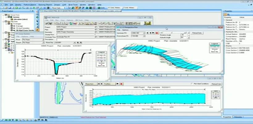
Hydraulic Simulation Modelling uses tools like HEC-RAS and MIKE FLOOD to simulate water flow behaviour through river channels and floodplains under different storm scenarios.
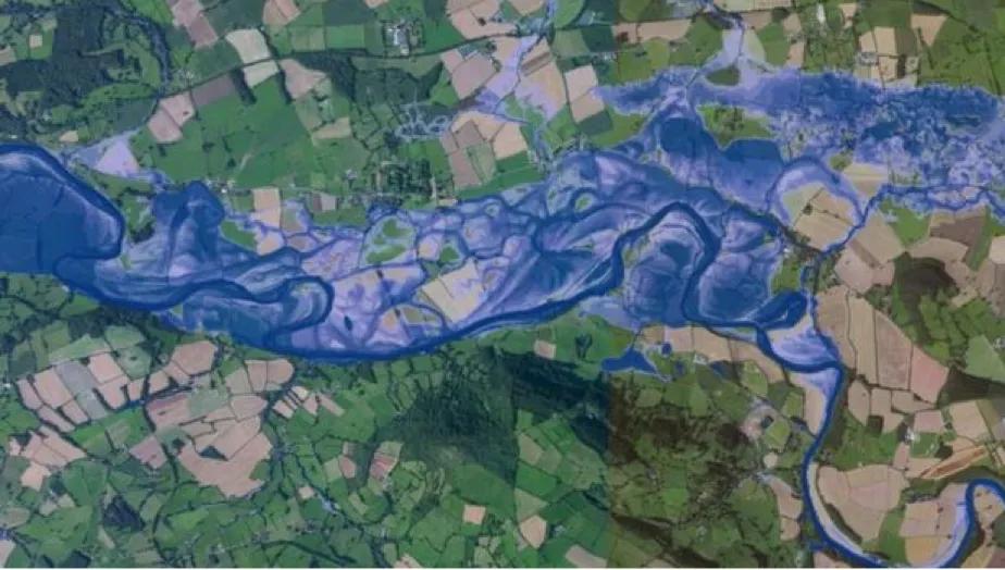
Floodplain and Terrain Analysis maps inundation extents at varying return periods — 1 in 10, 1 in 50, and 1 in 100-year flood events — essential for regulatory planning.
Flood Forecasting Systems integrate real-time sensor data with hydrological models to provide dynamic flood warning system outputs.
At the field investigation level, our team at Bhoojal Survey supports flood studies by conducting hydrogeological surveys using SSRMPATS Instrument, GER DETECT, and PQWT at site for open well and borewell location — providing advanced hydrological and geospatial survey solutions that feed directly into scientific flood investigation and analysis.
Applications of Flood Indicator Models in India
The flood indicator model framework finds application across a wide range of sectors and projects in India:
- Smart City Projects — Urban flood management planning for stormwater drainage, low-lying area assessment, and resilience zoning.
- River Basin Monitoring — Continuous river flood monitoring for major basins including the Ganga, Brahmaputra, Godavari, and Narmada.
- Highway and Bridge Infrastructure — Flood risk indicator analysis for National Highway alignments and bridge hydraulic design.
- Environmental Impact Assessment (EIA) — Mandatory flood hazard reporting for industrial and infrastructure clearances.
- Government Flood Mitigation Programs — Supporting NDMA and state disaster management authorities with scientific flood analysis and reporting.
- Irrigation and Agriculture Planning — Protecting farmland and irrigation infrastructure from seasonal inundation risks.
Why Choose Bhoojal Survey for Flood Modelling Consultancy?
Bhoojal Survey is a leading provider of professional flood modelling services and GIS flood mapping consultancy across India, trusted by government departments, infrastructure developers, and environmental agencies.
We offer:
- Experienced Hydrological Experts with hands-on flood risk assessment and watershed analysis experience
- Advanced GIS and Hydraulic Modelling Technologies for accurate, data-driven flood indicator model development
- Accurate Flood Risk Analysis aligned with NDMA, CWC, and Ministry of Jal Shakti standards
- Pan-India Hydrological Services covering urban, rural, river basin, and coastal flood scenarios
- Professional Reporting and Consultancy suitable for regulatory submissions and infrastructure planning
- Customized Environmental Solutions tailored to your project's specific terrain, scale, and compliance needs
When your project demands reliable flood hazard assessment services and hydrological flood analysis consultancy, Bhoojal Survey delivers results built on scientific rigour and field experience.
Conclusion
A well-developed flood indicator model is no longer optional — it is a necessity for responsible infrastructure planning, environmental management, and disaster preparedness in India. As climate change intensifies monsoon variability and urban expansion increases flood exposure, the demand for accurate, science-based flood monitoring and risk assessment will only grow.
Bhoojal Survey combines advanced flood modelling technologies, experienced hydrological expertise, and deep field knowledge to deliver environmental flood investigation solutions that protect lives, assets, and ecosystems.
📞 Contact Bhoojal Survey today for expert flood indicator model development, GIS flood mapping, and professional flood risk consultancy services across India.
Frequently Asked Questions (FAQs)
Q1. What is a flood indicator model? A flood indicator model is a scientific system that uses hydrological, topographic, and rainfall data to assess, predict, and map flood risk across specific areas — helping governments and planners make informed disaster management decisions.
Q2. How does flood prediction work in India? Flood prediction in India uses rainfall data, river discharge monitoring, GIS terrain analysis, and hydraulic simulation models to forecast flood behaviour across river basins and urban catchments, often integrated with early warning systems.
Q3. Why are flood monitoring systems important for infrastructure projects? Flood monitoring systems provide critical risk data that ensures bridges, highways, drainage networks, and buildings are designed to withstand flood events — reducing long-term structural damage and financial losses.
Q4. Which industries need flood risk assessment in India? Government agencies, smart city developers, highway and bridge engineers, real estate developers, irrigation departments, and environmental consultants all require professional flood risk assessment as part of planning, design, and regulatory compliance.
Q5. How accurate are flood indicator models? When built using quality field data, calibrated hydraulic models, and updated GIS layers, flood indicator models can achieve high accuracy — typically validated against historical flood events to ensure reliability for planning and design purposes.