Hydrological Survey — Flood Risk, Drainage & Water Flow Analysis
Bhoojal Survey delivers certified hydrological survey services across India — covering IMD rainfall analysis, catchment mapping, IDF curves, peak discharge calculation, and drainage design. Reports accepted by MoEF, CGWA, State PCBs, and NHAI.
[ Rated 4.9 by more than 500+ Customers Globally ]
24+
Team Members
12+
Sector Expertise
1170+
Happy Clients


Book Hydrological Survey Consultation
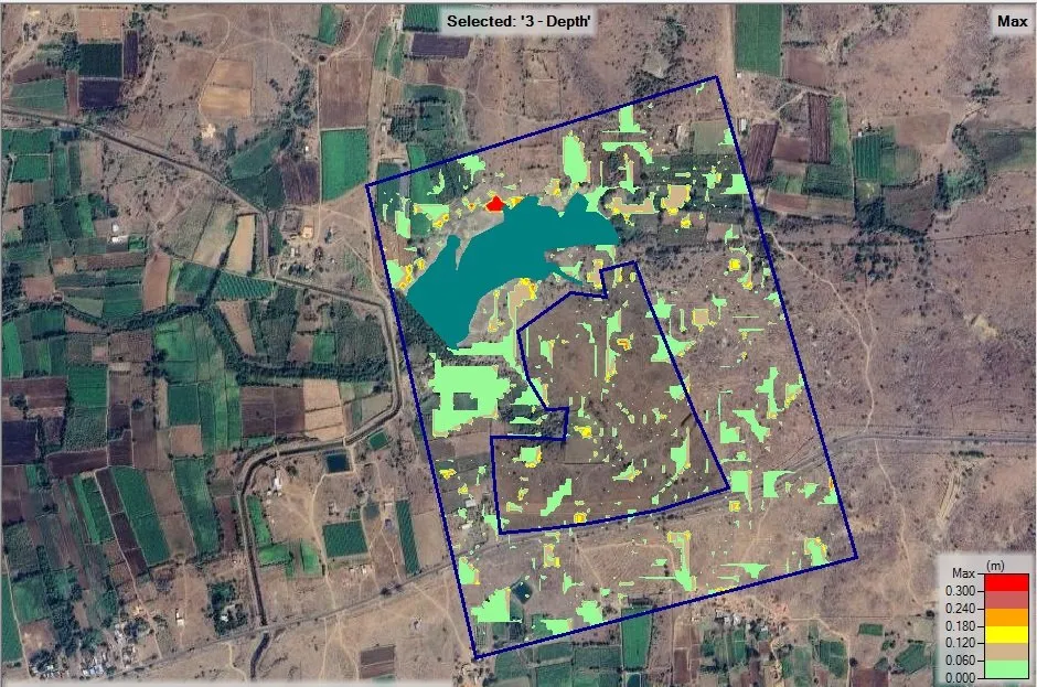
HEC-RAS 2D flood depth map showing maximum inundation zones — used by Bhoojal Survey for flood risk assessment and drainage planning as part of the hydrological survey workflow.
What is a Hydrological Survey?
Water does not respect project boundaries. It follows gravity, geology, and rainfall — and it will expose every weakness in a drainage system that was not designed on real data. Every year, infrastructure across India — roads, solar parks, industrial plants, and housing townships — suffers avoidable flood damage, waterlogging, and drainage failure. The common cause in almost every case: no hydrological survey was done before construction began.
A hydrological survey is a systematic, scientific investigation of how water moves across and beneath a landscape. It captures rainfall patterns, surface water runoff, drainage behaviour, and flood risk — translating all of it into engineering data your designers, planners, and regulators can act on. In India's increasingly erratic monsoon environment, a credible hydrological survey is not optional. It is a prerequisite for safe, compliant, and sustainable infrastructure.
Regulatory Note: MoEF, CGWA, State PCBs, and NHAI increasingly require a certified hydrological survey report as part of environmental clearance and site approval submissions. Bhoojal Survey reports are formatted for direct submission to all these authorities.
Why a Hydrological Survey Matters Before Any Project
A proper hydrological survey identifies flood-prone zones, calculates the maximum water flow your site will experience, and recommends safe drainage systems to manage it — all before a single brick is laid. Projects built without one face structural damage in the very first monsoon.
The risks of skipping a hydrological survey are well documented — waterlogging, drainage failure, regulatory rejection, and significant financial loss. Our flood modelling services extend this analysis further, providing hydraulic simulation for complex sites near rivers, dams, and flood plains.
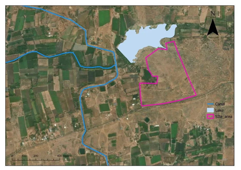
Satellite-based site view used in Bhoojal Survey catchment mapping — canal (blue), adjacent lake, and project boundary (pink outline) identified for pre-feasibility flood risk screening and drainage planning.
1. Rainfall Data Collection — The Foundation of Every Hydrological Survey
Rainfall data analysis is the starting point of every hydrological survey. Historical precipitation records are collected from the India Meteorological Department (IMD) and regional rain gauge stations — covering daily, monthly, and annual data over 20 to 50 years for the project location.
This long-term IMD data reveals seasonal patterns, extreme rainfall events, and drought cycles. Every subsequent calculation in the survey — design rainfall, IDF curves, peak discharge — depends on the accuracy of this base data. Without real, verified rainfall data, no survey result can be trusted.
2. Design Rainfall and Return Periods
Design rainfall defines the magnitude of storm event used to size drainage and flood control structures. Return periods — commonly 2-year, 5-year, 25-year, and 100-year events — express how frequently an extreme rainfall event is statistically likely to occur.
Selecting the correct return period for your project type is one of the most important decisions in any hydrological survey. A road drainage system may be designed for a 25-year storm. A dam spillway may require a 1000-year return period. Bhoojal Survey selects return periods based on project type, consequences of failure, and applicable Indian standards.
Need a Certified Hydrological Survey Report?
Our water resource engineers deliver IMD-backed rainfall analysis, catchment maps, IDF curves, and flood risk reports accepted by MoEF, CGWA, State PCBs, and NHAI across India.
Call +91-9691858058 Now View Flood Modelling Services3. IDF Curves — Intensity, Duration, Frequency
IDF (Intensity-Duration-Frequency) curves describe the relationship between rainfall intensity, storm duration, and return period for a specific location. Developed from long-term IMD rainfall data, they are a core tool in drainage design — telling engineers the maximum rainfall rate expected for any storm duration and frequency combination.
Accurately developed IDF curves prevent both under-designed drains — which flood — and over-designed systems — which waste project budget. Every hydrological survey by Bhoojal Survey generates site-specific IDF curves for 2, 5, 10, 25, 50, and 100-year return periods, ready for direct use in drainage and hydraulic design.
4. Catchment Mapping Using DEM and Satellite Data
A catchment is the area of land from which all water runoff drains to a common outlet. Catchment mapping defines this boundary precisely using Digital Elevation Models (DEMs) derived from satellite sources such as SRTM and Cartosat. GIS software processes the DEM to automatically trace catchment boundaries, map flow directions, and delineate drainage networks.
Accurate catchment mapping is the geographic foundation of the entire hydrological survey. Without it, flood and drainage estimates have no reliable spatial reference. Bhoojal Survey uses the latest available satellite-derived DEM data and GIS analysis tools to produce precise catchment maps for every project.
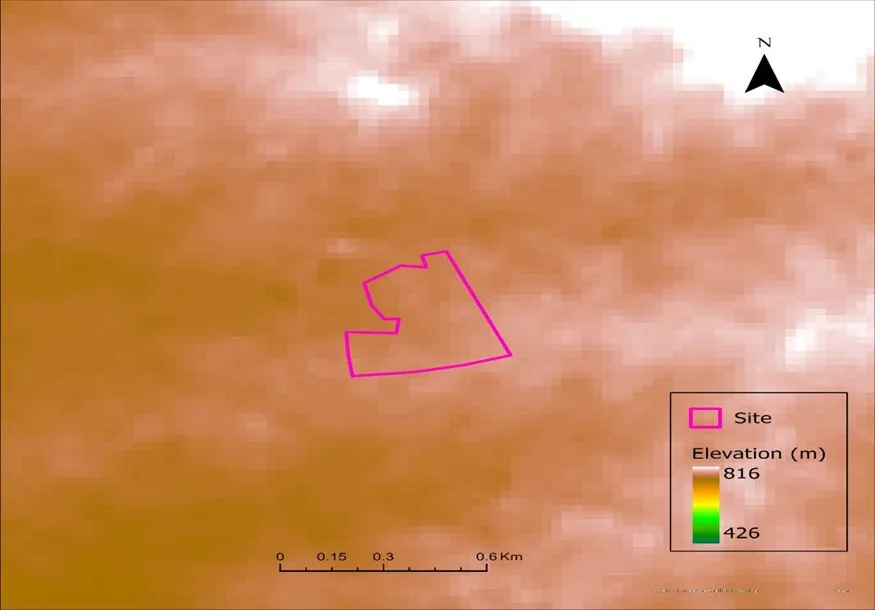
DEM elevation map (426m–816m) with project site boundary — used by Bhoojal Survey for catchment delineation, flow direction analysis, and slope calculation as part of the hydrological survey GIS workflow.
5. Land Use and Soil Type Analysis (LULC)
How much of any rainfall event becomes water runoff — and how fast — depends entirely on what covers the ground and what the soil is made of. Land Use Land Cover (LULC) analysis classifies the project area using satellite imagery into categories: agriculture, forest, urban built-up, bare ground, and water bodies.
Soil type data, sourced from NBSS&LUP records, defines permeability and infiltration rates. Together, LULC and soil data determine the runoff coefficient — the single most important parameter in peak discharge calculation. Bhoojal Survey integrates current-year satellite imagery with verified soil data for accurate, defensible LULC analysis on every project.
6. Flood Estimation — Peak Discharge Calculation
Peak discharge is the maximum volume of water flowing through a point in the drainage system during a design storm — the most critical number in any flood risk assessment. Methods used include the Rational Method for small catchments, the SCS-CN approach for medium basins, and the Unit Hydrograph Method for larger and more complex watersheds — all standard in Indian hydrological practice.
Accurate peak discharge calculation determines whether bridges, culverts, channels, and stormwater drains are correctly sized. Underestimate it and infrastructure floods. Overestimate it and the project overspends on unnecessary capacity. Bhoojal Survey applies the appropriate methodology for your specific site conditions and project type — producing defensible flood estimates ready for regulatory submission.
7. Drainage and Hydraulic Design
With catchment data, peak discharge values, and soil characteristics confirmed, the hydrological survey outputs directly inform drainage design. This covers sizing surface drains, stormwater channels, culverts, retention ponds, and outfall structures to safely handle design storm runoff without causing flooding or erosion.
Hydraulic design uses Manning's equation and HEC-RAS modelling to verify that drainage cross-sections perform adequately across all design return periods. Where required, Bhoojal Survey produces HEC-HMS and HEC-RAS model outputs ready for use by project engineers and for submission to regulatory authorities.
Get Your Hydrological Survey Report — Contact Bhoojal Survey
From IMD rainfall analysis to HEC-RAS hydraulic modelling — our certified team delivers the complete hydrological survey package your project requires.
Call Now: +91-9691858058 Flood Modelling Services8. Who Needs a Hydrological Survey?
A hydrological survey is required for any project where water flow can affect safety, performance, or regulatory clearance:
- Solar Park Developers: Flood risk assessment, stormwater drainage planning, and panel layout optimisation based on water flow across the site.
- Highway & Road Contractors: Culvert sizing, road drainage design, waterway clearance calculations, and flood plain encroachment assessments.
- Real Estate & Township Developers: Stormwater drainage master plans, flood zone mapping, and environmental clearance support.
- Industrial & Mining Projects: Mine dewatering analysis, effluent drainage design, water balance calculations, and MoEF environmental clearance reports.
- Government & Municipal Bodies: Urban flood management plans, master drainage network design, and watershed management reports.
- Agriculture & Irrigation Projects: Water availability analysis, canal drainage design, flood flow analysis, and groundwater recharge planning.
9. Final Deliverables — What You Receive
Every hydrological survey by Bhoojal Survey delivers a complete, signed, regulatory-ready report package:
- Rainfall Data Analysis Report — IMD-sourced historical rainfall, annual maximum series, and monsoon pattern summary.
- IDF Curves — Site-specific curves for 2, 5, 10, 25, 50, and 100-year return periods.
- GIS Catchment Map — DEM-derived catchment boundary, sub-basin delineation, flow direction, and drainage network maps.
- LULC Analysis — Satellite-based land use classification and runoff coefficient estimates for the project catchment.
- Peak Discharge Report — Calculated flood flows for all design return periods with full methodology documentation.
- Flood Risk Assessment Map — Inundation zone delineation and flood hazard classification for the project area.
- Drainage Design Recommendations — Channel sizing, culvert design, and retention pond specifications.
- Regulatory Compliance Summary — Formatted for MoEF, CGWA, State PCB, or NHAI submission as required.
10. Hydrological Survey vs Hydrogeological Survey
These two terms are often confused. A hydrological survey studies surface water — rainfall, runoff, flood flow, drainage, and watershed behaviour. A hydrogeological survey studies groundwater — aquifers, water table depth, underground water quality, and borewell site selection.
Many projects — especially large industrial and infrastructure developments — require both. Bhoojal Survey provides both services, either separately or as a combined study, giving you a single scientific partner for all water-related investigations your project requires.
Frequently Asked Questions — Hydrological Survey India
Q1: What is a hydrological survey?
A hydrological survey is a scientific investigation of the water cycle across a specific area — covering rainfall data analysis, surface water flow, flood risk assessment, drainage characteristics, and water runoff. It combines IMD rainfall data, satellite imagery, GIS mapping, and hydraulic modelling to produce a complete picture of how water moves across the project landscape. Bhoojal Survey's reports are accepted by MoEF, CGWA, and State PCBs across India.
Q2: Why is a hydrological survey important before construction?
Without a hydrological survey, construction projects risk waterlogging, drainage failure, structural flood damage, and regulatory rejection. It identifies flood-prone zones, calculates peak water flow, recommends safe drainage systems, and ensures the project meets MoEF, CGWA, and PCB clearance requirements. It is mandatory for highways, solar parks, industrial plants, and large residential townships.
Q3: What does a hydrological survey report include?
A Bhoojal Survey hydrological report includes: IMD-sourced rainfall data analysis, design rainfall and return period calculations, IDF curves, DEM-based catchment mapping, LULC analysis, peak discharge calculations, flood risk assessment maps, drainage design recommendations, HEC-RAS modelling outputs, and a regulatory compliance summary. Every report is signed by a certified hydrologist.
Q4: Who needs a hydrological survey?
Any project where water flow can affect safety, performance, or regulatory compliance needs a hydrological survey — including solar park developers, highway and road contractors, real estate and township developers, industrial and mining projects, municipal bodies, agricultural projects, and government agencies. Bhoojal Survey serves all these sectors across 15+ Indian states.
Q5: Can Bhoojal Survey provide reports for regulatory submissions?
Yes. Bhoojal Survey provides complete hydrological survey reports formatted for MoEF environmental clearance, CGWA NOC applications, State PCB submissions, NHAI road project clearances, and project lender requirements. Every report is prepared by certified hydrologists using IMD rainfall data, DEM-based catchment mapping, and peer-reviewed calculation methods — ensuring regulatory acceptance across all applicable authorities in India.
Conclusion — Commission a Hydrological Survey Before You Build
A hydrological survey is not a formality. It is the scientific foundation on which safe, compliant, and sustainable infrastructure is built. Whether you are developing a solar park in Rajasthan, a township in Madhya Pradesh, a highway in Maharashtra, or an industrial plant in Gujarat — understanding how water moves across your site before you build is the single most important risk management step you can take.
Bhoojal Survey brings IMD-backed rainfall analysis, GIS-based catchment mapping, and peer-reviewed peak discharge calculations to every project. Our reports are accepted by MoEF, CGWA, State PCBs, and project lenders — giving you regulatory confidence at every stage. Contact Bhoojal Survey today to begin your hydrological survey.
Scheme No. 114, Part-2, Indore, Madhya Pradesh – 452010, India
Phone: +91-9691858058
Email: [email protected]
Website: www.bhoojalsurvey.in
Hours: Monday – Saturday, 9:00 AM to 6:00 PM IST
Get a Certified Hydrological Survey Report — Contact Bhoojal Survey Today
IMD rainfall analysis, GIS catchment maps, IDF curves, peak discharge calculations, and flood risk reports — all in one certified package. Accepted by MoEF, CGWA, State PCBs, and NHAI.
Call +91-9691858058 Now Flood Modelling Services